Bridge Statistics for Palm Harbor, Florida (FL)
Condition, Traffic, Stress, Structural Evaluation, Project Costs
- National Bridge Inventory (NBI) Statistics
- 10Number of bridges
- 338ft / 103mTotal length
- 135,650Total average daily traffic
- 5,488Total average daily truck traffic
- National Bridge Inventory (NBI) Registered Bridges for Palm Harbor
- No street view available for this location
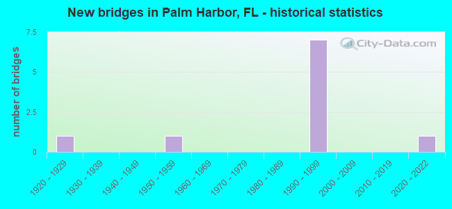
- New bridges - historical statistics
- 11920-1929
- 11950-1959
- 71990-1999
- 12020-2022

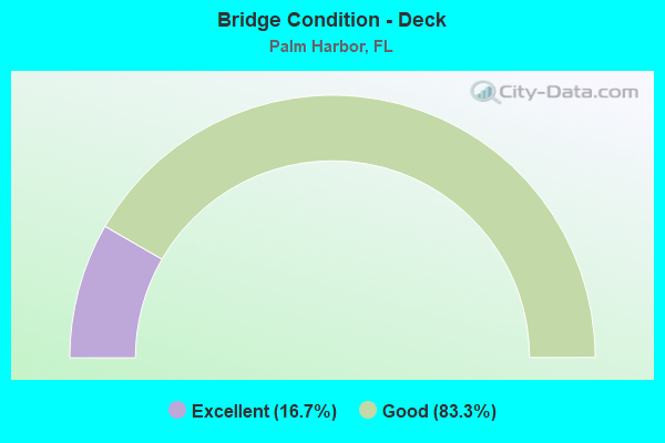
- Bridge Condition - Deck
- 16.7%Excellent
- 83.3%Good
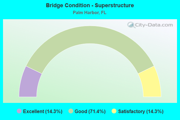
- Bridge Condition - Superstructure
- 14.3%Excellent
- 71.4%Good
- 14.3%Satisfactory
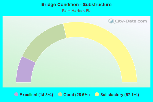
- Bridge Condition - Substructure
- 14.3%Excellent
- 28.6%Good
- 57.1%Satisfactory
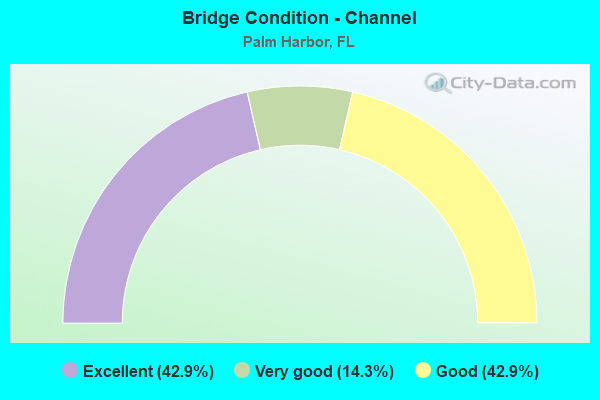
- Bridge Condition - Channel
- 42.9%Excellent
- 14.3%Very good
- 42.9%Good
Find on map >> Show street view
Structure Number: 150233, Location: 3.0MI. N OF CR-752 (Lat: 28.109678, Lng: -82.768600), Route carried "on" structure: Alternate US 19, Year Built: 1996, Status: Open, Structure Length: 1.00m (3.28ft), Average Daily Traffic: 15,000 (year 2020), Truck Traffic: 4%, Average Future Daily Traffic: 26,025 (year 2042), Design Load: HS 20+Mod, Features Intersected: PINELLAS TRAIL
Minimum Vertical Clearance: 30+ m (98+ ft), Kilometerpoint: 16.874, Lanes on structure: 2, Owner: State Highway Agency, Approaching Roadway Width: 16.0m (52.5ft), Skew: 3 degrees, Material/Design: Concrete, Design/Construction: Culvert, Number Of Spans In Main Unit: 1, Length of Maximum Span: 10.0m (32.8ft)
Condition: Culverts: Very good, Inventory Rating: 68.5 metric tons, Method Used To Determine Inventory Rating: Load Factor (LF), Structural Evaluation: Equal to present desirable criteria, Approach Roadway Alignment: Equal to present desirable criteria, Designated Inspection Frequency: Every 24 months, Inspection Date: March 2020
Find on map >> Show street view
Structure Number: 154004, Location: 0.25MI S OF WESTWINDS DR (Lat: 28.118578, Lng: -82.770172), Route carried "on" structure: City street , Year Built: 1958, Status: Open, Structure Length: 1.22m (4.00ft), Average Daily Traffic: 800 (year 2021), Truck Traffic: 1%, Average Future Daily Traffic: 1,388 (year 2041), Features Intersected: CROSSWINDS CANAL, Facility Carried by Structure: CROSSWINDS DRIVE
Minimum Vertical Clearance: 30+ m (98+ ft), Kilometerpoint: 0.000, Lanes on structure: 2, Owner: County Highway Agency, Approaching Roadway Width: 6.0m (19.7ft), Material/Design: Prestressed concrete, Design/Construction: Stringer/Multi-beam, Number Of Spans In Main Unit: 1, Length of Maximum Span: 12.2m (40.0ft), Curb or Sidewalk Widths: Left: 0.8m (2.6ft), Right: 0.0m, Curb-To-Curb Width: 7.3m (24.0ft), Out-to-Out Width: 8.9m (29.2ft)
Condition: Deck: Good, Superstructure: Good, Substructure: Good, Channel: Excellent, Operating Rating: 41.7 metric tons, Method Used To Determine Operating Rating: Load Factor (LF), Inventory Rating: 25.0 metric tons, Method Used To Determine Inventory Rating: Load Factor (LF), Structural Evaluation: Equal to present minimum criteria, Deck Geometry: Meets minimum limits, Waterway Adequacy: Better than present minimum criteria, Approach Roadway Alignment: Better than present minimum criteria, Designated Inspection Frequency: Every 24 months, Inspection Date: September 2021, Deck Structure Type: Concrete Cast-file-Place, Wearing Surface/Protective System: Wearing Surface: Bituminous
Find on map >> Show street view
Structure Number: 154101, Location: 0.2 MI NORTH OF US-19A (Lat: 28.058778, Lng: -82.775867), Route carried "on" structure: County highway , Year Built: 1923, Status: Open, Structure Length: 1.19m (3.90ft), Average Daily Traffic: 1,250 (year 2020), Truck Traffic: 4%, Average Future Daily Traffic: 2,169 (year 2042), Features Intersected: MINNOW CREEK, Facility Carried by Structure: ORANGE STREET
Minimum Vertical Clearance: 30+ m (98+ ft), Kilometerpoint: 0.375, Lanes on structure: 2, Owner: County Highway Agency, Approaching Roadway Width: 6.3m (20.7ft), Material/Design: Concrete, Design/Construction: Arch - Deck, Number Of Spans In Main Unit: 1, Length of Maximum Span: 11.9m (39.0ft), Curb-To-Curb Width: 6.3m (20.7ft), Out-to-Out Width: 7.1m (23.3ft)
Condition: Superstructure: Satisfactory, Substructure: Satisfactory, Channel: Excellent, Structural Evaluation: Equal to present minimum criteria, Deck Geometry: High priority of replacement, Waterway Adequacy: Better than present minimum criteria, Approach Roadway Alignment: Better than present minimum criteria, Designated Inspection Frequency: Every 24 months, Inspection Date: September 2021
Find on map >> Show street view
Structure Number: 154154, Location: 1.9Mi East of US-19 (Lat: 28.061033, Lng: -82.710478), Route carried "on" structure: County highway 752, Year Built: 1991, Status: Open, Structure Length: 12.04m (39.50ft), Average Daily Traffic: 18,000 (year 2019), Truck Traffic: 4%, Average Future Daily Traffic: 31,230 (year 2041), Design Load: HS 20, Features Intersected: LAKE TARPON CANAL
Minimum Vertical Clearance: 5.15m (16.90ft), Kilometerpoint: 5.433, Lanes on structure: 6, Owner: County Highway Agency, Approaching Roadway Width: 28.7m (94.2ft), Skew: 24 degrees, Material/Design: Prestressed concrete, Design/Construction: Stringer/Multi-beam, Number Of Spans In Main Unit: 7, Length of Maximum Span: 18.6m (61.0ft), Curb or Sidewalk Widths: Left: 1.5m (4.9ft), Right: 1.5m (4.9ft), Curb-To-Curb Width: 28.7m (94.2ft), Out-to-Out Width: 34.4m (112.9ft)
Condition: Deck: Good, Superstructure: Good, Substructure: Satisfactory, Channel: Good, Operating Rating: 49.5 metric tons, Method Used To Determine Operating Rating: Load Factor (LF), Inventory Rating: 44.2 metric tons, Method Used To Determine Inventory Rating: Load Factor (LF), Structural Evaluation: Equal to present minimum criteria, Deck Geometry: Better than present minimum criteria, Waterway Adequacy: Superior to present desirable criteria, Approach Roadway Alignment: Equal to present desirable criteria, Designated Inspection Frequency: Every 24 months, Underwater Inspection Frequency: Every 24 months, Inspection Date: July 2020, Underwater Inspection Date: June 2020, Deck Structure Type: Concrete Cast-file-Place
Find on map >> Show street view
Structure Number: 154155, Location: MCMULLEN BOOTH/OLD TAMPA (Lat: 28.062056, Lng: -82.710747), Route carried "on" structure: County highway 611, Year Built: 1991, Status: Open, Structure Length: 33.66m (110.43ft), Average Daily Traffic: 27,500 (year 2020), Truck Traffic: 3%, Average Future Daily Traffic: 47,713 (year 2042), Design Load: HS 20, Features Intersected: TARPON CNL & OLD TPA RD
Minimum Vertical Clearance: 30+ m (98+ ft), Kilometerpoint: 4.155, Lanes on structure: 2, Lanes under structure: 8, Owner: County Highway Agency, Approaching Roadway Width: 10.5m (34.4ft), Material/Design: Prestressed concrete, Design/Construction: Stringer/Multi-beam, Number Of Spans In Main Unit: 10, Length of Maximum Span: 44.8m (147.0ft), Curb-To-Curb Width: 12.1m (39.7ft), Out-to-Out Width: 13.0m (42.7ft)
Condition: Deck: Good, Superstructure: Good, Substructure: Satisfactory, Channel: Good, Operating Rating: 39.6 metric tons, Method Used To Determine Operating Rating: Load Factor (LF), Inventory Rating: 31.8 metric tons, Method Used To Determine Inventory Rating: Load Factor (LF), Structural Evaluation: Equal to present minimum criteria, Deck Geometry: Better than present minimum criteria, Underclear: High priority of corrective action, Waterway Adequacy: Superior to present desirable criteria, Approach Roadway Alignment: Better than present minimum criteria, Designated Inspection Frequency: Every 24 months, Underwater Inspection Frequency: Every 24 months, Inspection Date: July 2020, Underwater Inspection Date: June 2020, Deck Structure Type: Concrete Cast-file-Place
Find on map >> Show street view
Structure Number: 154156, Location: MCMULLEN BOOTH/OLD TAMPA (Lat: 28.061825, Lng: -82.710406), Route carried "on" structure: County highway 611, Year Built: 1991, Status: Open, Structure Length: 33.66m (110.43ft), Average Daily Traffic: 28,000 (year 2019), Truck Traffic: 6%, Average Future Daily Traffic: 48,580 (year 2041), Design Load: HS 20, Features Intersected: TARPON CNL & OLD TPA RD
Minimum Vertical Clearance: 30+ m (98+ ft), Kilometerpoint: 4.147, Lanes on structure: 2, Lanes under structure: 8, Base Highway Network: Yes, Owner: County Highway Agency, Approaching Roadway Width: 10.1m (33.1ft), Material/Design: Prestressed concrete, Design/Construction: Stringer/Multi-beam, Number Of Spans In Main Unit: 10, Length of Maximum Span: 46.0m (150.9ft), Curb-To-Curb Width: 12.1m (39.7ft), Out-to-Out Width: 13.0m (42.7ft)
Condition: Deck: Good, Superstructure: Good, Substructure: Good, Channel: Good, Operating Rating: 39.6 metric tons, Method Used To Determine Operating Rating: Load Factor (LF), Inventory Rating: 31.8 metric tons, Method Used To Determine Inventory Rating: Load Factor (LF), Structural Evaluation: Better than present minimum criteria, Deck Geometry: Better than present minimum criteria, Underclear: High priority of corrective action, Waterway Adequacy: Superior to present desirable criteria, Approach Roadway Alignment: Better than present minimum criteria, Designated Inspection Frequency: Every 24 months, Underwater Inspection Frequency: Every 24 months, Inspection Date: July 2020, Underwater Inspection Date: June 2020, Deck Structure Type: Concrete Cast-file-Place
Find on map >> Show street view
Structure Number: 154157, Location: AT OLD TAMPA ROAD (Lat: 28.062489, Lng: -82.710531), Route carried "on" structure: Ramp County highway 611, Year Built: 1991, Status: Open, Structure Length: 18.56m (60.89ft), Average Daily Traffic: 8,800 (year 2019), Truck Traffic: 4%, Average Future Daily Traffic: 15,268 (year 2041), Design Load: HS 20, Features Intersected: LAKE TARPON CANAL
Minimum Vertical Clearance: 30+ m (98+ ft), Kilometerpoint: 0.121, Lanes on structure: 1, Owner: County Highway Agency, Approaching Roadway Width: 8.1m (26.6ft), Skew: 4 degrees, Material/Design: Prestressed concrete, Design/Construction: Stringer/Multi-beam, Number Of Spans In Main Unit: 7, Length of Maximum Span: 26.5m (86.9ft), Curb-To-Curb Width: 8.1m (26.6ft), Out-to-Out Width: 9.0m (29.5ft)
Condition: Deck: Good, Superstructure: Good, Substructure: Satisfactory, Channel: Excellent, Operating Rating: 60.8 metric tons, Method Used To Determine Operating Rating: Load Factor (LF), Inventory Rating: 53.2 metric tons, Method Used To Determine Inventory Rating: Load Factor (LF), Structural Evaluation: Equal to present minimum criteria, Deck Geometry: Superior to present desirable criteria, Waterway Adequacy: Equal to present desirable criteria, Approach Roadway Alignment: Equal to present minimum criteria, Designated Inspection Frequency: Every 24 months, Underwater Inspection Frequency: Every 24 months, Inspection Date: July 2020, Underwater Inspection Date: June 2020, Deck Structure Type: Concrete Cast-file-Place
Find on map >> Show street view
Structure Number: 154561, Location: 0.02 Mi. E of Cardinal Tr (Lat: 28.119806, Lng: -82.768278), Route carried "on" structure: City street , Year Built: 2021, Status: Open, Structure Length: 1.65m (5.41ft), Average Daily Traffic: 800 (year 2021), Truck Traffic: 1%, Average Future Daily Traffic: 1,388 (year 2042), Design Load: HL 93, Features Intersected: Westwinds Canal, Facility Carried by Structure: Westwinds Dr
Minimum Vertical Clearance: 30+ m (98+ ft), Kilometerpoint: 0.000, Lanes on structure: 2, Owner: County Highway Agency, Approaching Roadway Width: 9.1m (29.9ft), Material/Design: Prestressed concrete, Design/Construction: Slab, Number Of Spans In Main Unit: 1, Length of Maximum Span: 16.5m (54.1ft), Curb or Sidewalk Widths: Left: 2.0m (6.6ft), Right: 2.0m (6.6ft), Curb-To-Curb Width: 9.1m (29.9ft), Out-to-Out Width: 13.9m (45.6ft)
Condition: Deck: Excellent, Superstructure: Excellent, Substructure: Excellent, Channel: Very good, Operating Rating: 71.2 metric tons, Method Used To Determine Operating Rating: Load and Resistance Factor (LRFR), Inventory Rating: 49.0 metric tons, Method Used To Determine Inventory Rating: Load and Resistance Factor (LRFR), Structural Evaluation: Superior to present desirable criteria, Deck Geometry: Equal to present minimum criteria, Waterway Adequacy: Better than present minimum criteria, Approach Roadway Alignment: Better than present minimum criteria, Designated Inspection Frequency: Every 24 months, Underwater Inspection Frequency: Every 24 months, Inspection Date: September 2021, Underwater Inspection Date: August 2021, Deck Structure Type: Concrete Precast Panels
Find on map >> Show street view
Structure Number: 154155, Location: MCMULLEN BOOTH/OLD TAMPA (Lat: 28.062056, Lng: -82.710747), Route carried "under" structure: County highway 752, Year Built: 1991, Structure Length: 0. m, Average Daily Traffic: 17,500 (year 2020), Truck Traffic: 3%, Features Intersected: TARPON CNL & OLD TPA RD, Facility Carried by Structure: CR-611 SB
Minimum Vertical Clearance: 6.25m (20.51ft), Kilometerpoint: 5.411, Lanes on structure: 2, Lanes under structure: 8, Material/Design: Prestressed concrete, Design/Construction: Stringer/Multi-beam, Length of Maximum Span: 44.8m (147.0ft)
Find on map >> Show street view
Structure Number: 154156, Location: MCMULLEN BOOTH/OLD TAMPA (Lat: 28.061825, Lng: -82.710406), Route carried "under" structure: County highway 584, Year Built: 1991, Structure Length: 0. m, Average Daily Traffic: 18,000 (year 2019), Truck Traffic: 4%, Features Intersected: TARPON CNL & OLD TPA RD, Facility Carried by Structure: CR-611 NB
Minimum Vertical Clearance: 5.15m (16.90ft), Kilometerpoint: 5.436, Lanes on structure: 2, Lanes under structure: 8, Material/Design: Prestressed concrete, Design/Construction: Stringer/Multi-beam, Length of Maximum Span: 46.0m (150.9ft)