Bridge Statistics for Palmview, Texas (TX)
Condition, Traffic, Stress, Structural Evaluation, Project Costs
- National Bridge Inventory (NBI) Statistics
- 16Number of bridges
- 180ft / 55.2mTotal length
- $4,000Total costs
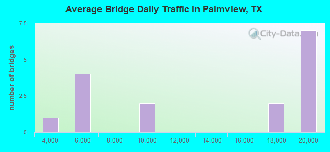
- 210,404Total average daily traffic
- 12,251Total average daily truck traffic
- National Bridge Inventory (NBI) Registered Bridges for Palmview
- No street view available for this location
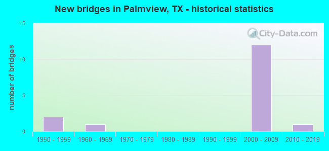
- New bridges - historical statistics
- 21950-1959
- 11960-1969
- 122000-2009
- 12010-2019
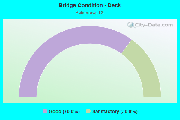
- Bridge Condition - Deck
- 70.0%Good
- 30.0%Satisfactory
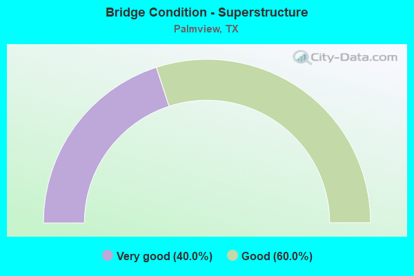
- Bridge Condition - Superstructure
- 40.0%Very good
- 60.0%Good
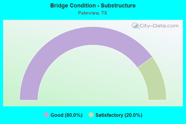
- Bridge Condition - Substructure
- 80.0%Good
- 20.0%Satisfactory
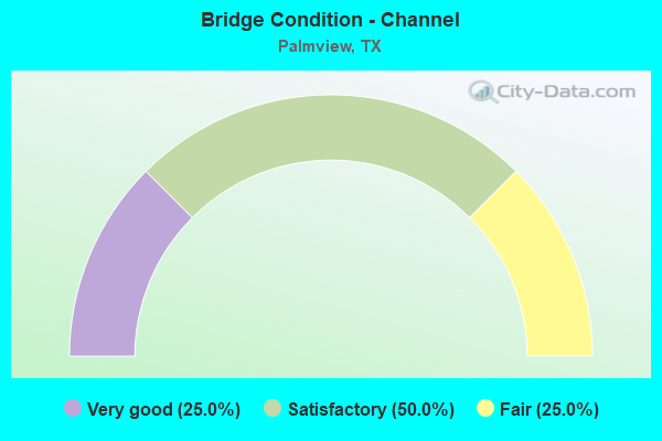
- Bridge Condition - Channel
- 25.0%Very good
- 50.0%Satisfactory
- 25.0%Fair
Find on map >> Show street view
Structure Number: 211090003917313, Location: 4.9 MI W OF SH 107 (Lat: 26.236150, Lng: -98.392506), Route carried "on" structure: US 83, Year Built: 2002, Status: Open, Structure Length: 7.50m (24.61ft), Average Daily Traffic: 19,456 (year 2019), Truck Traffic: 9%, Average Future Daily Traffic: 21,630 (year 2031), Design Load: HS 25 or greater, Features Intersected: FM 492
Minimum Vertical Clearance: 30+ m (98+ ft), Kilometerpoint: 20.669, Lanes on structure: 3, Lanes under structure: 8, Owner: State Highway Agency, Approaching Roadway Width: 15.2m (49.9ft), Material/Design: Prestressed concrete, Design/Construction: Stringer/Multi-beam, Number Of Spans In Main Unit: 1, Number Of Approach Spans: 2, Length of Maximum Span: 34.1m (111.9ft), Curb-To-Curb Width: 15.5m (50.9ft), Out-to-Out Width: 16.2m (53.1ft)
Condition: Deck: Good, Superstructure: Very good, Substructure: Good, Operating Rating: 68.0 metric tons, Method Used To Determine Operating Rating: Assigned rating based on Load Factor Design (LFD) reported in metric tons, Inventory Rating: 40.8 metric tons, Method Used To Determine Inventory Rating: Assigned rating based on Load Factor Design (LFD) reported in metric tons, Structural Evaluation: Better than present minimum criteria, Deck Geometry: Somewhat better than minimum adequacy, Underclear: Superior to present desirable criteria, Approach Roadway Alignment: Equal to present desirable criteria, Designated Inspection Frequency: Every 24 months, Inspection Date: May 2021, Deck Structure Type: Concrete Precast Panels
Find on map >> Show street view
Structure Number: 211090003917314, Location: 4.9 MI W OF SH 107 (Lat: 26.236308, Lng: -98.391722), Route carried "on" structure: US 83, Year Built: 2002, Status: Open, Structure Length: 7.50m (24.61ft), Average Daily Traffic: 19,748 (year 2019), Truck Traffic: 9%, Average Future Daily Traffic: 21,630 (year 2031), Design Load: HS 25 or greater, Features Intersected: FM 492
Minimum Vertical Clearance: 30+ m (98+ ft), Kilometerpoint: 20.669, Lanes on structure: 3, Lanes under structure: 8, Owner: State Highway Agency, Approaching Roadway Width: 15.2m (49.9ft), Material/Design: Prestressed concrete, Design/Construction: Stringer/Multi-beam, Number Of Spans In Main Unit: 1, Number Of Approach Spans: 2, Length of Maximum Span: 34.1m (111.9ft), Curb-To-Curb Width: 15.5m (50.9ft), Out-to-Out Width: 16.2m (53.1ft)
Condition: Deck: Good, Superstructure: Very good, Substructure: Good, Operating Rating: 68.0 metric tons, Method Used To Determine Operating Rating: Assigned rating based on Load Factor Design (LFD) reported in metric tons, Inventory Rating: 40.8 metric tons, Method Used To Determine Inventory Rating: Assigned rating based on Load Factor Design (LFD) reported in metric tons, Structural Evaluation: Better than present minimum criteria, Deck Geometry: Somewhat better than minimum adequacy, Underclear: Superior to present desirable criteria, Approach Roadway Alignment: Equal to present desirable criteria, Designated Inspection Frequency: Every 24 months, Inspection Date: May 2021, Deck Structure Type: Concrete Precast Panels
Find on map >> Show street view
Structure Number: 211090003917315, Location: 2.20 MI SE OF FM 492 (Lat: 26.224692, Lng: -98.356356), Route carried "on" structure: US 83, Year Built: 1965, Year Reconstructed: 2002, Status: Open, Structure Length: 3.75m (12.30ft), Average Daily Traffic: 19,456 (year 2019), Truck Traffic: 7%, Average Future Daily Traffic: 32,970 (year 2031), Design Load: HS 20, Features Intersected: EDINBURG MAIN CANAL
Minimum Vertical Clearance: 30+ m (98+ ft), Kilometerpoint: 24.662, Lanes on structure: 6, Owner: State Highway Agency, Approaching Roadway Width: 26.2m (86.0ft), Skew: 31 degrees, Material/Design: Concrete, Design/Construction: Stringer/Multi-beam, Number Of Spans In Main Unit: 3, Length of Maximum Span: 12.5m (41.0ft), Curb-To-Curb Width: 26.2m (86.0ft), Out-to-Out Width: 27.7m (90.9ft)
Condition: Deck: Good, Superstructure: Good, Substructure: Satisfactory, Channel: Satisfactory, Operating Rating: 59.9 metric tons, Method Used To Determine Operating Rating: Load Factor (LF), Inventory Rating: 35.4 metric tons, Method Used To Determine Inventory Rating: Load Factor (LF), Structural Evaluation: Equal to present minimum criteria, Deck Geometry: Meets minimum limits, Waterway Adequacy: Superior to present desirable criteria, Approach Roadway Alignment: Equal to present desirable criteria, Designated Inspection Frequency: Every 24 months, Underwater Inspection Frequency: Every 60 months, Inspection Date: April 2021, Underwater Inspection Date: Febuary 2019, Deck Structure Type: Concrete Cast-file-Place, Wearing Surface/Protective System: Wearing Surface: Bituminous
Find on map >> Show street view
Structure Number: 211090003917317, Location: 3.5 MI W OF SH 107 (Lat: 26.233136, Lng: -98.371194), Route carried "on" structure: US 83, Year Built: 2002, Status: Open, Structure Length: 7.50m (24.61ft), Average Daily Traffic: 19,456 (year 2019), Truck Traffic: 7%, Average Future Daily Traffic: 32,970 (year 2031), Design Load: HS 25 or greater, Features Intersected: BENTSEN PALM RD
Minimum Vertical Clearance: 30+ m (98+ ft), Kilometerpoint: 22.824, Lanes on structure: 3, Lanes under structure: 8, Owner: State Highway Agency, Approaching Roadway Width: 15.2m (49.9ft), Material/Design: Prestressed concrete, Design/Construction: Stringer/Multi-beam, Number Of Spans In Main Unit: 1, Number Of Approach Spans: 2, Length of Maximum Span: 34.1m (111.9ft), Curb-To-Curb Width: 15.5m (50.9ft), Out-to-Out Width: 16.2m (53.1ft)
Condition: Deck: Good, Superstructure: Good, Substructure: Good, Operating Rating: 68.0 metric tons, Method Used To Determine Operating Rating: Assigned rating based on Load Factor Design (LFD) reported in metric tons, Inventory Rating: 40.8 metric tons, Method Used To Determine Inventory Rating: Assigned rating based on Load Factor Design (LFD) reported in metric tons, Structural Evaluation: Better than present minimum criteria, Deck Geometry: Somewhat better than minimum adequacy, Underclear: Superior to present desirable criteria, Approach Roadway Alignment: Equal to present desirable criteria, Designated Inspection Frequency: Every 24 months, Inspection Date: May 2021, Deck Structure Type: Concrete Precast Panels
Find on map >> Show street view
Structure Number: 211090003917318, Location: 3.5 MI W OF SH 107 (Lat: 26.233292, Lng: -98.370422), Route carried "on" structure: US 83, Year Built: 2002, Status: Open, Structure Length: 7.50m (24.61ft), Average Daily Traffic: 19,748 (year 2019), Truck Traffic: 7%, Average Future Daily Traffic: 32,970 (year 2031), Design Load: HS 25 or greater, Features Intersected: BENTSEN PALM RD
Minimum Vertical Clearance: 30+ m (98+ ft), Kilometerpoint: 22.824, Lanes on structure: 3, Lanes under structure: 8, Owner: State Highway Agency, Approaching Roadway Width: 15.2m (49.9ft), Material/Design: Prestressed concrete, Design/Construction: Stringer/Multi-beam, Number Of Spans In Main Unit: 1, Number Of Approach Spans: 2, Length of Maximum Span: 34.1m (111.9ft), Curb-To-Curb Width: 15.5m (50.9ft), Out-to-Out Width: 16.2m (53.1ft)
Condition: Deck: Good, Superstructure: Very good, Substructure: Good, Operating Rating: 68.0 metric tons, Method Used To Determine Operating Rating: Assigned rating based on Load Factor Design (LFD) reported in metric tons, Inventory Rating: 40.8 metric tons, Method Used To Determine Inventory Rating: Assigned rating based on Load Factor Design (LFD) reported in metric tons, Structural Evaluation: Better than present minimum criteria, Deck Geometry: Somewhat better than minimum adequacy, Underclear: Superior to present desirable criteria, Approach Roadway Alignment: Equal to present desirable criteria, Designated Inspection Frequency: Every 24 months, Inspection Date: May 2021, Deck Structure Type: Concrete Precast Panels
Find on map >> Show street view
Structure Number: 211090003917319, Location: 3.0 MI W OF SH 107 (Lat: 26.231267, Lng: -98.363019), Route carried "on" structure: US 83, Year Built: 2002, Status: Open, Structure Length: 7.89m (25.89ft), Average Daily Traffic: 19,456 (year 2019), Truck Traffic: 7%, Average Future Daily Traffic: 32,970 (year 2031), Design Load: HS 25 or greater, Features Intersected: LA HOMA/FM 2894
Minimum Vertical Clearance: 30+ m (98+ ft), Kilometerpoint: 23.667, Lanes on structure: 3, Lanes under structure: 8, Owner: State Highway Agency, Approaching Roadway Width: 15.2m (49.9ft), Skew: 9 degrees, Material/Design: Prestressed concrete, Design/Construction: Stringer/Multi-beam, Number Of Spans In Main Unit: 1, Number Of Approach Spans: 2, Length of Maximum Span: 36.9m (121.1ft), Curb-To-Curb Width: 15.5m (50.9ft), Out-to-Out Width: 16.2m (53.1ft)
Condition: Deck: Satisfactory, Superstructure: Good, Substructure: Good, Operating Rating: 68.0 metric tons, Method Used To Determine Operating Rating: Assigned rating based on Load Factor Design (LFD) reported in metric tons, Inventory Rating: 40.8 metric tons, Method Used To Determine Inventory Rating: Assigned rating based on Load Factor Design (LFD) reported in metric tons, Structural Evaluation: Better than present minimum criteria, Deck Geometry: Somewhat better than minimum adequacy, Underclear: Equal to present minimum criteria, Approach Roadway Alignment: Equal to present desirable criteria, Designated Inspection Frequency: Every 24 months, Inspection Date: April 2021, Deck Structure Type: Concrete Precast Panels
Find on map >> Show street view
Structure Number: 21109000391732, Location: 3.0 MI W OF SH 107 (Lat: 26.231178, Lng: -98.362306), Route carried "on" structure: US 83, Year Built: 2002, Status: Open, Structure Length: 7.89m (25.89ft), Average Daily Traffic: 19,748 (year 2019), Truck Traffic: 7%, Average Future Daily Traffic: 32,970 (year 2031), Design Load: HS 25 or greater, Features Intersected: LA HOMA/FM 2894
Minimum Vertical Clearance: 30+ m (98+ ft), Kilometerpoint: 23.662, Lanes on structure: 3, Lanes under structure: 8, Owner: State Highway Agency, Approaching Roadway Width: 15.2m (49.9ft), Skew: 9 degrees, Material/Design: Prestressed concrete, Design/Construction: Stringer/Multi-beam, Number Of Spans In Main Unit: 1, Number Of Approach Spans: 2, Length of Maximum Span: 36.9m (121.1ft), Curb-To-Curb Width: 15.5m (50.9ft), Out-to-Out Width: 16.2m (53.1ft)
Condition: Deck: Satisfactory, Superstructure: Good, Substructure: Good, Operating Rating: 68.0 metric tons, Method Used To Determine Operating Rating: Assigned rating based on Load Factor Design (LFD) reported in metric tons, Inventory Rating: 40.8 metric tons, Method Used To Determine Inventory Rating: Assigned rating based on Load Factor Design (LFD) reported in metric tons, Structural Evaluation: Better than present minimum criteria, Deck Geometry: Somewhat better than minimum adequacy, Underclear: Equal to present minimum criteria, Approach Roadway Alignment: Equal to present desirable criteria, Designated Inspection Frequency: Every 24 months, Inspection Date: April 2021, Deck Structure Type: Concrete Precast Panels
Find on map >> Show street view
Structure Number: 211090086201002, Location: 0.25 MI N OF BU 83 (Lat: 26.227392, Lng: -98.393683), Route carried "on" structure: State highway 492, Year Built: 1958, Status: Open, Structure Length: 1.83m (6.00ft), Average Daily Traffic: 4,966 (year 2020), Truck Traffic: 5%, Average Future Daily Traffic: 5,860 (year 2033), Features Intersected: EDINBURG MAIN CANAL
Minimum Vertical Clearance: 30+ m (98+ ft), Kilometerpoint: 16.562, Lanes on structure: 2, Owner: State Highway Agency, Approaching Roadway Width: 5.5m (18.0ft), Skew: 1 degrees, Material/Design: Concrete continuous, Design/Construction: Slab, Number Of Spans In Main Unit: 2, Length of Maximum Span: 9.1m (29.9ft), Curb-To-Curb Width: 7.1m (23.3ft), Out-to-Out Width: 7.7m (25.3ft)
Condition: Deck: Good, Superstructure: Good, Substructure: Good, Channel: Satisfactory, Operating Rating: 62.6 metric tons, Method Used To Determine Operating Rating: Load Factor (LF), Inventory Rating: 37.2 metric tons, Method Used To Determine Inventory Rating: Load Factor (LF), Structural Evaluation: Better than present minimum criteria, Deck Geometry: High priority of replacement, Waterway Adequacy: Equal to present minimum criteria, Approach Roadway Alignment: Equal to present desirable criteria, Length Of Structure Improvement: 1.83m (6.00ft), Designated Inspection Frequency: Every 24 months, Underwater Inspection Frequency: Every 60 months, Inspection Date: April 2021, Underwater Inspection Date: January 2017, Deck Structure Type: Concrete Cast-file-Place, Wearing Surface/Protective System: Wearing Surface: Bituminous
Find on map >> Show street view
Structure Number: 211090P00569001, Location: 0.05 MI N OF BU 83 (Lat: 26.224997, Lng: -98.400786), Route carried "on" structure: County highway , Year Built: 1950, Status: Open, Structure Length: 1.89m (6.20ft), Average Daily Traffic: 4,010 (year 2016), Truck Traffic: 3%, Average Future Daily Traffic: 4,210 (year 2036), Features Intersected: EDINBURG MAIN CANAL, Facility Carried by Structure: ABRAM ROAD
Minimum Vertical Clearance: 30+ m (98+ ft), Kilometerpoint: 12.472, Lanes on structure: 2, Owner: County Highway Agency, Approaching Roadway Width: 6.1m (20.0ft), Skew: 2 degrees, Material/Design: Concrete, Design/Construction: Slab, Number Of Spans In Main Unit: 3, Length of Maximum Span: 6.4m (21.0ft), Curb-To-Curb Width: 6.2m (20.3ft), Out-to-Out Width: 6.7m (22.0ft)
Condition: Deck: Good, Superstructure: Good, Substructure: Satisfactory, Channel: Fair, Operating Rating: 32.7 metric tons, Method Used To Determine Operating Rating: Field evaluation and documented engineering judgment, Inventory Rating: 24.5 metric tons, Method Used To Determine Inventory Rating: Field evaluation and documented engineering judgment, Structural Evaluation: Equal to present minimum criteria, Deck Geometry: High priority of replacement, Waterway Adequacy: Better than present minimum criteria, Approach Roadway Alignment: Equal to present desirable criteria, Length Of Structure Improvement: 1.89m (6.20ft), Designated Inspection Frequency: Every 24 months, Underwater Inspection Frequency: Every 60 months, Inspection Date: May 2020, Underwater Inspection Date: August 2020, Bridge Improvement Cost: $3,000, Roadway Improvement Cost: $1,000, Total Project Cost: $4,000, Deck Structure Type: Concrete Cast-file-Place, Wearing Surface/Protective System: Wearing Surface: Bituminous
Find on map >> Show street view
Structure Number: 211090P08876001, Location: 0.60 MI S OF IH 2 (Lat: 26.225408, Lng: -98.372164), Route carried "on" structure: City street , Year Built: 2014, Status: Open, Structure Length: 1.98m (6.50ft), Average Daily Traffic: 2,000 (year 2014), Truck Traffic: 2%, Average Future Daily Traffic: 7,000 (year 2031), Design Load: HL 93, Features Intersected: EDINBURG MAIN CANAL, Facility Carried by Structure: S BENTSEN PALM DR
Minimum Vertical Clearance: 30+ m (98+ ft), Kilometerpoint: 0.966, Lanes on structure: 2, Owner: City or Municipal Highway Agency, Approaching Roadway Width: 8.5m (27.9ft), Skew: 1 degrees, Material/Design: Prestressed concrete, Design/Construction: Stringer/Multi-beam, Number Of Spans In Main Unit: 1, Length of Maximum Span: 19.8m (65.0ft), Curb-To-Curb Width: 9.4m (30.8ft), Out-to-Out Width: 10.4m (34.1ft)
Condition: Deck: Satisfactory, Superstructure: Very good, Substructure: Good, Channel: Very good, Operating Rating: 54.4 metric tons, Method Used To Determine Operating Rating: Assigned ratings based on Load and Resistance Factor Design (LRFD) reported in metric tons, Inventory Rating: 32.7 metric tons, Method Used To Determine Inventory Rating: Assigned ratings based on Load and Resistance Factor Design (LRFD) reported in metric tons, Structural Evaluation: Better than present minimum criteria, Deck Geometry: Somewhat better than minimum adequacy, Waterway Adequacy: Better than present minimum criteria, Approach Roadway Alignment: Equal to present desirable criteria, Designated Inspection Frequency: Every 24 months, Inspection Date: June 2020, Deck Structure Type: Concrete Precast Panels
Find on map >> Show street view
Structure Number: 211090003917313, Location: 4.9 MI W OF SH 107 (Lat: 26.236150, Lng: -98.392506), Route carried "under" structure: State highway 492, Year Built: 2002, Structure Length: 0. m, Average Daily Traffic: 4,180 (year 2013), Truck Traffic: 5%, Features Intersected: FM 492, Facility Carried by Structure: US 83 EB
Minimum Vertical Clearance: 5.59m (18.34ft), Kilometerpoint: 15.593, Lanes on structure: 3, Lanes under structure: 8, Material/Design: Prestressed concrete, Design/Construction: Stringer/Multi-beam, Length of Maximum Span: 34.1m (111.9ft)
Find on map >> Show street view
Structure Number: 211090003917314, Location: 4.9 MI W OF SH 107 (Lat: 26.236308, Lng: -98.391722), Route carried "under" structure: State highway 492, Year Built: 2002, Structure Length: 0. m, Average Daily Traffic: 4,180 (year 2013), Truck Traffic: 5%, Features Intersected: FM 492, Facility Carried by Structure: US 83 WB
Minimum Vertical Clearance: 5.69m (18.67ft), Kilometerpoint: 15.578, Lanes on structure: 3, Lanes under structure: 8, Material/Design: Prestressed concrete, Design/Construction: Stringer/Multi-beam, Length of Maximum Span: 34.1m (111.9ft)
Find on map >> Show street view
Structure Number: 211090003917317, Location: 3.5 MI W OF SH 107 (Lat: 26.233136, Lng: -98.371194), Route carried "under" structure: City street , Year Built: 2002, Structure Length: 0. m, Average Daily Traffic: 9,500 (year 2009), Features Intersected: BENTSEN PALM RD, Facility Carried by Structure: US 83 EB
Minimum Vertical Clearance: 5.64m (18.50ft), Lanes on structure: 3, Lanes under structure: 8, Material/Design: Prestressed concrete, Design/Construction: Stringer/Multi-beam, Length of Maximum Span: 34.1m (111.9ft)
Find on map >> Show street view
Structure Number: 211090003917318, Location: 3.5 MI W OF SH 107 (Lat: 26.233292, Lng: -98.370422), Route carried "under" structure: City street , Year Built: 2002, Structure Length: 0. m, Average Daily Traffic: 9,500 (year 2009), Features Intersected: BENTSEN PALM RD, Facility Carried by Structure: US 83 WB
Minimum Vertical Clearance: 5.66m (18.57ft), Lanes on structure: 3, Lanes under structure: 8, Material/Design: Prestressed concrete, Design/Construction: Stringer/Multi-beam, Length of Maximum Span: 34.1m (111.9ft)
Find on map >> Show street view
Structure Number: 211090003917319, Location: 3.0 MI W OF SH 107 (Lat: 26.231267, Lng: -98.363017), Route carried "under" structure: State highway 2894, Year Built: 2002, Structure Length: 0. m, Average Daily Traffic: 17,500 (year 2010), Truck Traffic: 3%, Features Intersected: LA HOMA/FM 2894, Facility Carried by Structure: US 83 EB
Minimum Vertical Clearance: 5.08m (16.67ft), Kilometerpoint: 6.698, Lanes on structure: 3, Lanes under structure: 8, Material/Design: Prestressed concrete, Design/Construction: Stringer/Multi-beam, Length of Maximum Span: 36.9m (121.1ft)
Find on map >> Show street view
Structure Number: 21109000391732, Location: 3.0 MI W OF SH 107 (Lat: 26.231178, Lng: -98.362306), Route carried "under" structure: State highway 2894, Year Built: 2002, Structure Length: 0. m, Average Daily Traffic: 17,500 (year 2010), Truck Traffic: 3%, Features Intersected: LA HOMA/FM 2894, Facility Carried by Structure: US 83 WB
Minimum Vertical Clearance: 5.61m (18.41ft), Kilometerpoint: 6.680, Lanes on structure: 3, Lanes under structure: 8, Material/Design: Prestressed concrete, Design/Construction: Stringer/Multi-beam, Length of Maximum Span: 36.9m (121.1ft)