Bridge Statistics for Park Ridge, Illinois (IL)
Condition, Traffic, Stress, Structural Evaluation, Project Costs
- National Bridge Inventory (NBI) Statistics
- 17Number of bridges
- 203ft / 62.4mTotal length
- $10,452,000Total costs
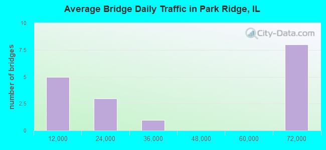
- 660,950Total average daily traffic
- 82,280Total average daily truck traffic
- National Bridge Inventory (NBI) Registered Bridges for Park Ridge
- No street view available for this location
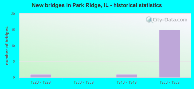
- New bridges - historical statistics
- 11920-1929
- 11940-1949
- 151950-1959
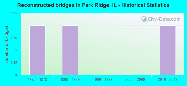
- Reconstructed bridges - Historical Statistics
- 11970-1979
- 11980-1989
- 01990-1999
- 02000-2009
- 12010-2019
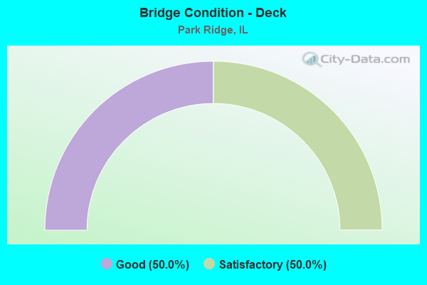
- Bridge Condition - Deck
- 50.0%Good
- 50.0%Satisfactory
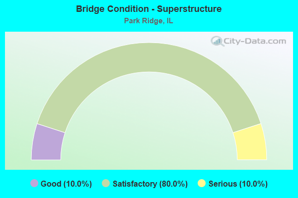
- Bridge Condition - Superstructure
- 10.0%Good
- 80.0%Satisfactory
- 10.0%Serious
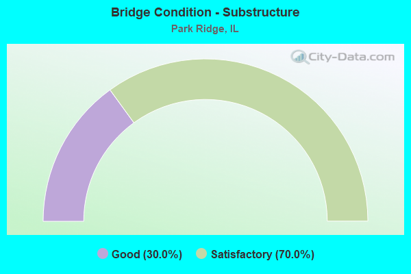
- Bridge Condition - Substructure
- 30.0%Good
- 70.0%Satisfactory
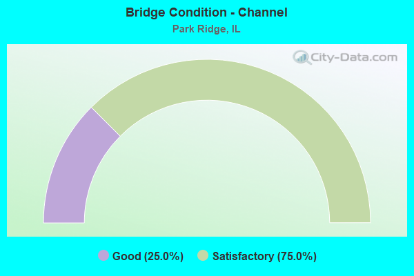
- Bridge Condition - Channel
- 25.0%Good
- 75.0%Satisfactory
Find on map >> Show street view
Structure Number: 160829, Location: 0.3 M E I-294 (Lat: 42.010289, Lng: -87.861844), Route carried "on" structure: Other road , Year Built: 1955, Year Reconstructed: 2017, Status: Open, Structure Length: 5.70m (18.70ft), Average Daily Traffic: 26,100 (year 2021), Truck Traffic: 6%, Average Future Daily Traffic: 31,518 (year 2032), Design Load: HS 20, Features Intersected: DES PLAINES RIVER, Facility Carried by Structure: TOUHY AVE
Minimum Vertical Clearance: 30+ m (98+ ft), Kilometerpoint: 33.248, Lanes on structure: 4, Base Highway Network: Yes, Owner: State Highway Agency, Approaching Roadway Width: 18.3m (60.0ft), Skew: 34 degrees, Material/Design: Steel, Design/Construction: Stringer/Multi-beam, Number Of Spans In Main Unit: 5, Length of Maximum Span: 17.7m (58.1ft), Curb or Sidewalk Widths: Left: 1.2m (3.9ft), Right: 1.2m (3.9ft), Curb-To-Curb Width: 15.5m (50.9ft), Out-to-Out Width: 19.8m (65.0ft)
Condition: Deck: Satisfactory, Superstructure: Serious, Substructure: Good, Channel: Satisfactory, Operating Rating: 27.9 metric tons, Method Used To Determine Operating Rating: Load Factor (LF) rating reported by rating factor (RF) method using MS18 loading, Inventory Rating: 16.8 metric tons, Method Used To Determine Inventory Rating: Load Factor (LF) rating reported by rating factor (RF) method using MS18 loading, Structural Evaluation: High priority of corrective action, Deck Geometry: Meets minimum limits, Waterway Adequacy: Equal to present desirable criteria, Approach Roadway Alignment: Equal to present desirable criteria, Length Of Structure Improvement: 5.70m (18.70ft), Designated Inspection Frequency: Every 12 months, Other Special Inspection Frequency: Every 6 months, Inspection Date: January 2022, Other Special Inspection Date: January 2022, Bridge Improvement Cost: $876,000, Roadway Improvement Cost: $88,000, Total Project Cost: $1,314,000, Deck Structure Type: Concrete Cast-file-Place, Wearing Surface/Protective System: Wearing Surface: Latex Concrete, Deck Protection: Epoxy Coated Reinforcing
Find on map >> Show street view
Structure Number: 160832, Location: 0.4 M E I-294 (Lat: 41.995850, Lng: -87.859783), Route carried "on" structure: Other road , Year Built: 1928, Year Reconstructed: 1979, Status: Open, Structure Length: 7.15m (23.46ft), Average Daily Traffic: 9,450 (year 2021), Truck Traffic: 3%, Average Future Daily Traffic: 10,712 (year 2032), Design Load: HS 20, Features Intersected: DES PLAINES RIVER, Facility Carried by Structure: DEVON AVE
Minimum Vertical Clearance: 30+ m (98+ ft), Kilometerpoint: 1.143, Lanes on structure: 4, Base Highway Network: Yes, Owner: State Highway Agency, Approaching Roadway Width: 15.8m (51.8ft), Material/Design: Prestressed concrete, Design/Construction: Stringer/Multi-beam, Number Of Spans In Main Unit: 3, Length of Maximum Span: 23.2m (76.1ft), Curb or Sidewalk Widths: Left: 1.5m (4.9ft), Right: 1.5m (4.9ft), Curb-To-Curb Width: 13.4m (44.0ft), Out-to-Out Width: 17.1m (56.1ft)
Condition: Deck: Satisfactory, Superstructure: Satisfactory, Substructure: Satisfactory, Channel: Satisfactory, Operating Rating: 42.8 metric tons, Method Used To Determine Operating Rating: Load Factor (LF) rating reported by rating factor (RF) method using MS18 loading, Inventory Rating: 25.6 metric tons, Method Used To Determine Inventory Rating: Load Factor (LF) rating reported by rating factor (RF) method using MS18 loading, Structural Evaluation: Equal to present minimum criteria, Deck Geometry: High priority of replacement, Waterway Adequacy: Equal to present desirable criteria, Approach Roadway Alignment: Equal to present desirable criteria, Length Of Structure Improvement: 7.71m (25.30ft), Designated Inspection Frequency: Every 24 months, Inspection Date: April 2020, Bridge Improvement Cost: $1,700,000, Roadway Improvement Cost: $170,000, Total Project Cost: $2,550,000, Deck Structure Type: Concrete Cast-file-Place, Wearing Surface/Protective System: Deck Protection: Epoxy Coated Reinforcing
Find on map >> Show street view
Structure Number: 169761, Location: 0.7 M S US 14 P11 (Lat: 42.029758, Lng: -87.865697), Route carried "on" structure: Interstate 294, Year Built: 1958, Status: Open, Structure Length: 12.47m (40.91ft), Average Daily Traffic: 68,800 (year 2020), Truck Traffic: 14%, Average Future Daily Traffic: 68,083 (year 2032), Features Intersected: C&NW RR & BUSSE RD
Minimum Vertical Clearance: 30+ m (98+ ft), Kilometerpoint: 15.176, Lanes on structure: 4, Lanes under structure: 4, Base Highway Network: Yes, Toll: On toll road, Owner: State Toll Authority, Approaching Roadway Width: 15.8m (51.8ft), Skew: 4 degrees, Material/Design: Prestressed concrete, Design/Construction: Stringer/Multi-beam, Number Of Spans In Main Unit: 4, Length of Maximum Span: 34.7m (113.8ft), Curb-To-Curb Width: 14.2m (46.6ft), Out-to-Out Width: 18.6m (61.0ft)
Condition: Deck: Satisfactory, Superstructure: Satisfactory, Substructure: Satisfactory, Operating Rating: 97.2 metric tons, Method Used To Determine Operating Rating: Load Factor (LF) rating reported by rating factor (RF) method using MS18 loading, Inventory Rating: 60.6 metric tons, Method Used To Determine Inventory Rating: Load Factor (LF) rating reported by rating factor (RF) method using MS18 loading, Structural Evaluation: Equal to present minimum criteria, Deck Geometry: High priority of replacement, Underclear: Somewhat better than minimum adequacy, Approach Roadway Alignment: Equal to present desirable criteria, Length Of Structure Improvement: 13.08m (42.91ft), Designated Inspection Frequency: Every 24 months, Inspection Date: April 2019, Bridge Improvement Cost: $2,196,000, Roadway Improvement Cost: $220,000, Total Project Cost: $3,294,000, Deck Structure Type: Concrete Cast-file-Place, Wearing Surface/Protective System: Wearing Surface: Bituminous, Membrane: Built-up
Find on map >> Show street view
Structure Number: 169762, Location: 0.7 M S US 14 P11 (Lat: 42.029617, Lng: -87.865681), Route carried "on" structure: Interstate 294, Year Built: 1958, Status: Open, Structure Length: 12.47m (40.91ft), Average Daily Traffic: 68,800 (year 2020), Truck Traffic: 14%, Average Future Daily Traffic: 68,083 (year 2032), Features Intersected: C&NW RR & BUSSE RD
Minimum Vertical Clearance: 30+ m (98+ ft), Kilometerpoint: 15.192, Lanes on structure: 4, Lanes under structure: 4, Base Highway Network: Yes, Toll: On toll road, Owner: State Toll Authority, Approaching Roadway Width: 15.8m (51.8ft), Skew: 4 degrees, Material/Design: Steel, Design/Construction: Stringer/Multi-beam, Number Of Spans In Main Unit: 4, Length of Maximum Span: 34.7m (113.8ft), Curb-To-Curb Width: 14.2m (46.6ft), Out-to-Out Width: 18.6m (61.0ft)
Condition: Deck: Good, Superstructure: Satisfactory, Substructure: Good, Operating Rating: 85.5 metric tons, Method Used To Determine Operating Rating: Load Factor (LF) rating reported by rating factor (RF) method using MS18 loading, Inventory Rating: 51.2 metric tons, Method Used To Determine Inventory Rating: Load Factor (LF) rating reported by rating factor (RF) method using MS18 loading, Structural Evaluation: Equal to present minimum criteria, Deck Geometry: High priority of replacement, Underclear: Somewhat better than minimum adequacy, Approach Roadway Alignment: Equal to present desirable criteria, Length Of Structure Improvement: 13.08m (42.91ft), Designated Inspection Frequency: Every 24 months, Inspection Date: April 2019, Bridge Improvement Cost: $2,196,000, Roadway Improvement Cost: $220,000, Total Project Cost: $3,294,000, Deck Structure Type: Concrete Cast-file-Place, Wearing Surface/Protective System: Wearing Surface: Bituminous, Membrane: Built-up
Find on map >> Show street view
Structure Number: 169763, Location: 0.7 M S US 14 P11 (Lat: 42.027153, Lng: -87.865639), Route carried "on" structure: Interstate 294, Year Built: 1958, Status: Open, Structure Length: 3.66m (12.01ft), Average Daily Traffic: 68,800 (year 2020), Truck Traffic: 14%, Average Future Daily Traffic: 68,083 (year 2032), Features Intersected: ALGONQUIN RD
Minimum Vertical Clearance: 30+ m (98+ ft), Kilometerpoint: 15.433, Lanes on structure: 3, Lanes under structure: 4, Base Highway Network: Yes, Toll: On toll road, Owner: State Toll Authority, Approaching Roadway Width: 15.8m (51.8ft), Skew: 5 degrees, Material/Design: Steel, Design/Construction: Stringer/Multi-beam, Number Of Spans In Main Unit: 1, Length of Maximum Span: 35.7m (117.1ft), Curb-To-Curb Width: 14.2m (46.6ft), Out-to-Out Width: 18.6m (61.0ft)
Condition: Deck: Good, Superstructure: Satisfactory, Substructure: Satisfactory, Operating Rating: 80.7 metric tons, Method Used To Determine Operating Rating: Load Factor (LF) rating reported by rating factor (RF) method using MS18 loading, Inventory Rating: 48.3 metric tons, Method Used To Determine Inventory Rating: Load Factor (LF) rating reported by rating factor (RF) method using MS18 loading, Structural Evaluation: Equal to present minimum criteria, Deck Geometry: Meets minimum limits, Underclear: Meets minimum limits, Approach Roadway Alignment: Equal to present desirable criteria, Designated Inspection Frequency: Every 24 months, Inspection Date: April 2019, Deck Structure Type: Concrete Cast-file-Place, Wearing Surface/Protective System: Wearing Surface: Bituminous, Membrane: Built-up
Find on map >> Show street view
Structure Number: 169764, Location: 0.7 M S US 14 P11 (Lat: 42.026989, Lng: -87.865639), Route carried "on" structure: Interstate 294, Year Built: 1958, Status: Open, Structure Length: 3.66m (12.01ft), Average Daily Traffic: 68,800 (year 2020), Truck Traffic: 14%, Average Future Daily Traffic: 68,083 (year 2032), Features Intersected: ALGONQUIN RD
Minimum Vertical Clearance: 30+ m (98+ ft), Kilometerpoint: 15.449, Lanes on structure: 3, Lanes under structure: 4, Base Highway Network: Yes, Toll: On toll road, Owner: State Toll Authority, Approaching Roadway Width: 15.8m (51.8ft), Skew: 5 degrees, Material/Design: Steel, Design/Construction: Stringer/Multi-beam, Number Of Spans In Main Unit: 1, Length of Maximum Span: 35.7m (117.1ft), Curb-To-Curb Width: 14.2m (46.6ft), Out-to-Out Width: 18.6m (61.0ft)
Condition: Deck: Satisfactory, Superstructure: Satisfactory, Substructure: Satisfactory, Operating Rating: 97.2 metric tons, Method Used To Determine Operating Rating: Load Factor (LF) rating reported by rating factor (RF) method using MS18 loading, Inventory Rating: 71.3 metric tons, Method Used To Determine Inventory Rating: Load Factor (LF) rating reported by rating factor (RF) method using MS18 loading, Structural Evaluation: Equal to present minimum criteria, Deck Geometry: Meets minimum limits, Underclear: Meets minimum limits, Approach Roadway Alignment: Equal to present desirable criteria, Designated Inspection Frequency: Every 24 months, Inspection Date: April 2019, Deck Structure Type: Concrete Cast-file-Place, Wearing Surface/Protective System: Wearing Surface: Bituminous, Membrane: Built-up
Find on map >> Show street view
Structure Number: 169765, Location: 1 M S US 14 P11 (Lat: 42.024744, Lng: -87.865664), Route carried "on" structure: Interstate 294, Year Built: 1958, Status: Open, Structure Length: 2.13m (6.99ft), Average Daily Traffic: 68,800 (year 2020), Truck Traffic: 14%, Average Future Daily Traffic: 68,083 (year 2032), Features Intersected: OAKTON ST
Minimum Vertical Clearance: 30+ m (98+ ft), Kilometerpoint: 15.691, Lanes on structure: 3, Lanes under structure: 4, Base Highway Network: Yes, Toll: On toll road, Owner: State Toll Authority, Approaching Roadway Width: 15.8m (51.8ft), Material/Design: Prestressed concrete, Design/Construction: Stringer/Multi-beam, Number Of Spans In Main Unit: 1, Length of Maximum Span: 20.4m (66.9ft), Curb-To-Curb Width: 14.2m (46.6ft), Out-to-Out Width: 18.6m (61.0ft)
Condition: Deck: Good, Superstructure: Good, Substructure: Good, Operating Rating: 74.5 metric tons, Method Used To Determine Operating Rating: Load Factor (LF) rating reported by rating factor (RF) method using MS18 loading, Inventory Rating: 44.7 metric tons, Method Used To Determine Inventory Rating: Load Factor (LF) rating reported by rating factor (RF) method using MS18 loading, Structural Evaluation: Better than present minimum criteria, Deck Geometry: Meets minimum limits, Approach Roadway Alignment: Equal to present desirable criteria, Designated Inspection Frequency: Every 24 months, Inspection Date: April 2019, Deck Structure Type: Concrete Cast-file-Place, Wearing Surface/Protective System: Wearing Surface: Bituminous, Membrane: Built-up
Find on map >> Show street view
Structure Number: 169766, Location: 1 M S US 14 P11 (Lat: 42.024594, Lng: -87.865664), Route carried "on" structure: Interstate 294, Year Built: 1958, Status: Open, Structure Length: 2.13m (6.99ft), Average Daily Traffic: 68,800 (year 2020), Truck Traffic: 14%, Average Future Daily Traffic: 276,100 (year 2037), Features Intersected: OAKTON ST
Minimum Vertical Clearance: 30+ m (98+ ft), Kilometerpoint: 15.707, Lanes on structure: 4, Lanes under structure: 4, Base Highway Network: Yes, Toll: On toll road, Owner: State Toll Authority, Approaching Roadway Width: 15.8m (51.8ft), Material/Design: Concrete continuous, Number Of Spans In Main Unit: 1, Length of Maximum Span: 20.4m (66.9ft), Curb-To-Curb Width: 14.2m (46.6ft), Out-to-Out Width: 18.6m (61.0ft)
Condition: Deck: Satisfactory, Superstructure: Satisfactory, Substructure: Satisfactory, Operating Rating: 74.8 metric tons, Method Used To Determine Operating Rating: Load Factor (LF) rating reported by rating factor (RF) method using MS18 loading, Inventory Rating: 44.7 metric tons, Method Used To Determine Inventory Rating: Load Factor (LF) rating reported by rating factor (RF) method using MS18 loading, Structural Evaluation: Equal to present minimum criteria, Deck Geometry: High priority of replacement, Approach Roadway Alignment: Equal to present desirable criteria, Designated Inspection Frequency: Every 24 months, Inspection Date: April 2019, Deck Structure Type: Concrete Cast-file-Place, Wearing Surface/Protective System: Wearing Surface: Bituminous, Membrane: Built-up
Find on map >> Show street view
Structure Number: 169767, Location: 0.6 M S ILL 62 P11 (Lat: 42.018208, Lng: -87.866494), Route carried "on" structure: Interstate 294, Year Built: 1958, Year Reconstructed: 1980, Status: Open, Structure Length: 6.52m (21.39ft), Average Daily Traffic: 68,800 (year 2020), Truck Traffic: 14%, Average Future Daily Traffic: 68,083 (year 2032), Features Intersected: DES PLAINES RIV
Minimum Vertical Clearance: 30+ m (98+ ft), Kilometerpoint: 16.415, Lanes on structure: 3, Base Highway Network: Yes, Toll: On toll road, Owner: State Toll Authority, Approaching Roadway Width: 15.8m (51.8ft), Skew: 3 degrees, Material/Design: Prestressed concrete, Design/Construction: Stringer/Multi-beam, Number Of Spans In Main Unit: 3, Length of Maximum Span: 25.0m (82.0ft), Curb-To-Curb Width: 14.2m (46.6ft), Out-to-Out Width: 18.6m (61.0ft)
Condition: Deck: Good, Superstructure: Satisfactory, Substructure: Satisfactory, Channel: Good, Operating Rating: 72.3 metric tons, Method Used To Determine Operating Rating: Load Factor (LF) rating reported by rating factor (RF) method using MS18 loading, Inventory Rating: 43.4 metric tons, Method Used To Determine Inventory Rating: Load Factor (LF) rating reported by rating factor (RF) method using MS18 loading, Structural Evaluation: Equal to present minimum criteria, Deck Geometry: Meets minimum limits, Waterway Adequacy: Equal to present desirable criteria, Approach Roadway Alignment: Equal to present desirable criteria, Designated Inspection Frequency: Every 24 months, Underwater Inspection Frequency: Every 60 months, Inspection Date: June 2020, Underwater Inspection Date: April 2018, Deck Structure Type: Concrete Cast-file-Place, Wearing Surface/Protective System: Wearing Surface: Bituminous, Membrane: Built-up
Find on map >> Show street view
Structure Number: 169768, Location: 0.6 M S ILL 62 P11 (Lat: 42.018069, Lng: -87.866564), Route carried "on" structure: Interstate 294, Year Built: 1958, Status: Open, Structure Length: 6.52m (21.39ft), Average Daily Traffic: 68,800 (year 2020), Truck Traffic: 14%, Average Future Daily Traffic: 68,083 (year 2032), Features Intersected: DES PLAINES RIV
Minimum Vertical Clearance: 30+ m (98+ ft), Kilometerpoint: 16.431, Lanes on structure: 3, Base Highway Network: Yes, Toll: On toll road, Owner: State Toll Authority, Approaching Roadway Width: 15.8m (51.8ft), Skew: 3 degrees, Material/Design: Prestressed concrete, Design/Construction: Stringer/Multi-beam, Number Of Spans In Main Unit: 3, Length of Maximum Span: 25.0m (82.0ft), Curb-To-Curb Width: 14.2m (46.6ft), Out-to-Out Width: 18.6m (61.0ft)
Condition: Deck: Good, Superstructure: Satisfactory, Substructure: Satisfactory, Channel: Satisfactory, Operating Rating: 66.4 metric tons, Method Used To Determine Operating Rating: Load Factor (LF) rating reported by rating factor (RF) method using MS18 loading, Inventory Rating: 39.9 metric tons, Method Used To Determine Inventory Rating: Load Factor (LF) rating reported by rating factor (RF) method using MS18 loading, Structural Evaluation: Equal to present minimum criteria, Deck Geometry: Meets minimum limits, Waterway Adequacy: Superior to present desirable criteria, Approach Roadway Alignment: Equal to present desirable criteria, Designated Inspection Frequency: Every 24 months, Underwater Inspection Frequency: Every 60 months, Inspection Date: June 2020, Underwater Inspection Date: April 2018, Deck Structure Type: Concrete Cast-file-Place, Wearing Surface/Protective System: Wearing Surface: Bituminous, Membrane: Built-up
Find on map >> Show street view
Structure Number: 16083, Location: 1.8 M E I294 P11 (Lat: 42.011089, Lng: -87.833450), Route carried "under" structure: Other road , Year Built: 1941, Structure Length: 0. m, Average Daily Traffic: 23,000 (year 2021), Truck Traffic: 6%, Features Intersected: TOUHY AVE, Facility Carried by Structure: C&NW RR
Minimum Vertical Clearance: 4.39m (14.40ft), Kilometerpoint: 35.566, Lanes under structure: 4, Material/Design: Steel, Length of Maximum Span: 24.7m (81.0ft)
Find on map >> Show street view
Structure Number: 169761, Location: 0.7 M S US 14 P11 (Lat: 42.029683, Lng: -87.865797), Route carried "under" structure: Other road , Year Built: 1958, Structure Length: 0. m, Average Daily Traffic: 3,000 (year 2021), Truck Traffic: 6%, Features Intersected: C&NW RR & BUSSE RD, Facility Carried by Structure: I-294 SB
Minimum Vertical Clearance: 7.01m (23.00ft), Kilometerpoint: 16.318, Lanes on structure: 4, Lanes under structure: 4, Toll: On toll road, Material/Design: Prestressed concrete, Design/Construction: Stringer/Multi-beam, Length of Maximum Span: 34.7m (113.8ft)
Find on map >> Show street view
Structure Number: 169762, Location: 0.7 M S US 14 P11 (Lat: 42.029617, Lng: -87.865681), Route carried "under" structure: Other road , Year Built: 1958, Structure Length: 0. m, Average Daily Traffic: 8,100 (year 2021), Truck Traffic: 4%, Features Intersected: C&NW RR & BUSSE RD, Facility Carried by Structure: I-294 NB
Minimum Vertical Clearance: 7.01m (23.00ft), Kilometerpoint: 16.334, Lanes on structure: 4, Lanes under structure: 4, Toll: On toll road, Material/Design: Steel, Design/Construction: Stringer/Multi-beam, Length of Maximum Span: 34.7m (113.8ft)
Find on map >> Show street view
Structure Number: 169763, Location: 0.7 M S US 14 P11 (Lat: 42.027108, Lng: -87.865756), Route carried "under" structure: Other road , Year Built: 1958, Structure Length: 0. m, Average Daily Traffic: 6,500 (year 2018), Truck Traffic: 3%, Features Intersected: ALGONQUIN RD, Facility Carried by Structure: I-294 SB
Minimum Vertical Clearance: 4.34m (14.24ft), Kilometerpoint: 11.539, Lanes on structure: 3, Lanes under structure: 4, Toll: On toll road, Material/Design: Steel, Design/Construction: Stringer/Multi-beam, Length of Maximum Span: 35.7m (117.1ft)
Find on map >> Show street view
Structure Number: 169764, Location: 0.7 M S US 14 P11 (Lat: 42.026989, Lng: -87.865639), Route carried "under" structure: Other road , Year Built: 1958, Structure Length: 0. m, Average Daily Traffic: 4,000 (year 2021), Truck Traffic: 2%, Features Intersected: ALGONQUIN RD, Facility Carried by Structure: I-294 NB
Minimum Vertical Clearance: 4.34m (14.24ft), Kilometerpoint: 11.571, Lanes on structure: 3, Lanes under structure: 4, Toll: On toll road, Material/Design: Steel, Design/Construction: Stringer/Multi-beam, Length of Maximum Span: 35.7m (117.1ft)
Find on map >> Show street view
Structure Number: 169765, Location: 1 M S US 14 P11 (Lat: 42.024603, Lng: -87.865378), Route carried "under" structure: Other road , Year Built: 1958, Structure Length: 0. m, Average Daily Traffic: 15,200 (year 2021), Truck Traffic: 4%, Features Intersected: OAKTON ST, Facility Carried by Structure: I-294 NB
Minimum Vertical Clearance: 4.34m (14.24ft), Kilometerpoint: 6.244, Lanes on structure: 3, Lanes under structure: 4, Toll: On toll road, Material/Design: Prestressed concrete, Design/Construction: Stringer/Multi-beam, Length of Maximum Span: 20.4m (66.9ft)
Find on map >> Show street view
Structure Number: 169766, Location: 1 M S US 14 P11 (Lat: 42.024594, Lng: -87.865664), Route carried "under" structure: Other road , Year Built: 1958, Structure Length: 0. m, Average Daily Traffic: 15,200 (year 2021), Truck Traffic: 4%, Features Intersected: OAKTON ST, Facility Carried by Structure: I-294 SB
Minimum Vertical Clearance: 4.34m (14.24ft), Kilometerpoint: 6.228, Lanes on structure: 4, Lanes under structure: 4, Toll: On toll road, Material/Design: Concrete continuous, Length of Maximum Span: 20.4m (66.9ft)