Bridge Statistics for Pascagoula, Mississippi (MS)
Condition, Traffic, Stress, Structural Evaluation, Project Costs
- National Bridge Inventory (NBI) Statistics
- 37Number of bridges
- 2,372ft / 723mTotal length
- $1,004,189,000Total costs
- 267,090Total average daily traffic
- 23,831Total average daily truck traffic
- National Bridge Inventory (NBI) Registered Bridges for Pascagoula
- No street view available for this location
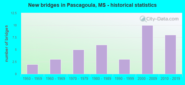
- New bridges - historical statistics
- 21950-1959
- 31960-1969
- 51970-1979
- 61980-1989
- 31990-1999
- 102000-2009
- 82010-2019
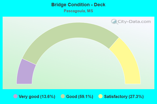
- Bridge Condition - Deck
- 13.6%Very good
- 59.1%Good
- 27.3%Satisfactory
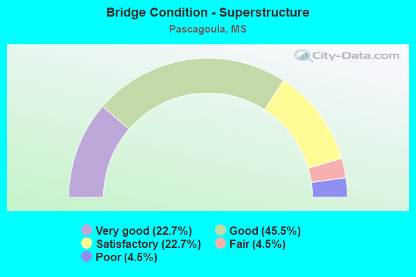
- Bridge Condition - Superstructure
- 22.7%Very good
- 45.5%Good
- 22.7%Satisfactory
- 4.5%Fair
- 4.5%Poor
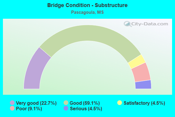
- Bridge Condition - Substructure
- 22.7%Very good
- 59.1%Good
- 4.5%Satisfactory
- 9.1%Poor
- 4.5%Serious
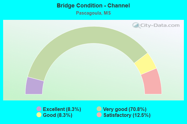
- Bridge Condition - Channel
- 8.3%Excellent
- 70.8%Very good
- 8.3%Good
- 12.5%Satisfactory
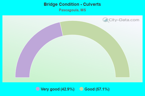
- Bridge Condition - Culverts
- 42.9%Very good
- 57.1%Good
Find on map >> Show street view
Structure Number: 21000900300683, Location: 0.9 MI W SR 613 (Lat: 30.373267, Lng: -88.567950), Route carried "on" structure: US 90, Year Built: 2003, Status: Open, Structure Length: 109.09m (357.91ft), Average Daily Traffic: 35,000 (year 2020), Truck Traffic: 3%, Average Future Daily Traffic: 35,000 (year 2040), Design Load: HS 20, Features Intersected: EAST PASCAGOULA RIVER
Minimum Vertical Clearance: 30+ m (98+ ft), Kilometerpoint: 26.937, Lanes on structure: 8, Base Highway Network: Yes (Inventory Route: 9, Subroute: 1), Owner: State Highway Agency, Approaching Roadway Width: 39.0m (128.0ft), Skew: 30 degrees, Navigation Control: Yes ( Vertical Clearance: 24.3m (79.7ft), Horizontal Clearance: 45.7m (149.9ft)), Material/Design: Prestressed concrete continuous, Design/Construction: Stringer/Multi-beam, Number Of Spans In Main Unit: 3, Number Of Approach Spans: 24, Length of Maximum Span: 76.2m (250.0ft), Curb-To-Curb Width: 40.2m (131.9ft), Out-to-Out Width: 41.7m (136.8ft)
Condition: Deck: Good, Superstructure: Good, Substructure: Good, Channel: Good, Operating Rating: 73.6 metric tons, Method Used To Determine Operating Rating: Load Factor (LF), Inventory Rating: 22.3 metric tons, Method Used To Determine Inventory Rating: Load Factor (LF), Structural Evaluation: Somewhat better than minimum adequacy, Deck Geometry: Superior to present desirable criteria, Waterway Adequacy: Equal to present desirable criteria, Approach Roadway Alignment: Equal to present desirable criteria, Designated Inspection Frequency: Every 24 months, Underwater Inspection Frequency: Every 60 months, Inspection Date: August 2020, Underwater Inspection Date: June 2019, Deck Structure Type: Concrete Cast-file-Place, Wearing Surface/Protective System: Deck Protection: Epoxy Coated Reinforcing
Find on map >> Show street view
Structure Number: 31006110300009, Location: 3.3 MI S US 90 (Lat: 30.345125, Lng: -88.493989), Route carried "on" structure: State highway 611, Year Built: 2015, Status: Open, Structure Length: 3.35m (10.99ft), Average Daily Traffic: 4,500 (year 2020), Truck Traffic: 12%, Average Future Daily Traffic: 4,500 (year 2040), Design Load: HS 20, Features Intersected: CHEVRON PIPELINES
Minimum Vertical Clearance: 30+ m (98+ ft), Kilometerpoint: 1.146, Lanes on structure: 5, Owner: State Highway Agency, Approaching Roadway Width: 22.8m (74.8ft), Material/Design: Steel, Design/Construction: Stringer/Multi-beam, Number Of Spans In Main Unit: 1, Length of Maximum Span: 32.5m (106.6ft), Curb-To-Curb Width: 23.0m (75.5ft), Out-to-Out Width: 23.9m (78.4ft)
Condition: Deck: Very good, Superstructure: Very good, Substructure: Very good, Inventory Rating: 68.1 metric tons, Method Used To Determine Inventory Rating: Load Factor (LF), Structural Evaluation: Equal to present desirable criteria, Deck Geometry: Equal to present minimum criteria, Approach Roadway Alignment: Equal to present desirable criteria, Designated Inspection Frequency: Every 24 months, Inspection Date: Febuary 2020, Deck Structure Type: Concrete Cast-file-Place
Find on map >> Show street view
Structure Number: 3100611030004, Location: SR 611 OVER US 90 (Lat: 30.390061, Lng: -88.505500), Route carried "on" structure: State highway 611, Year Built: 2013, Status: Open, Structure Length: 21.67m (71.10ft), Average Daily Traffic: 12,000 (year 2020), Truck Traffic: 9%, Average Future Daily Traffic: 12,000 (year 2040), Design Load: HS 20, Features Intersected: US 90/CSXT RR
Minimum Vertical Clearance: 30+ m (98+ ft), Kilometerpoint: 6.437, Lanes on structure: 4, Lanes under structure: 6, Base Highway Network: Yes (Inventory Route: 61, Subroute: 1), Owner: State Highway Agency, Approaching Roadway Width: 31.8m (104.3ft), Skew: 20 degrees, Material/Design: Prestressed concrete continuous, Design/Construction: Stringer/Multi-beam, Number Of Spans In Main Unit: 6, Length of Maximum Span: 36.0m (118.1ft), Curb-To-Curb Width: 31.8m (104.3ft), Out-to-Out Width: 33.0m (108.3ft)
Condition: Deck: Good, Superstructure: Very good, Substructure: Very good, Operating Rating: 84.1 metric tons, Method Used To Determine Operating Rating: Load Factor (LF), Inventory Rating: 40.5 metric tons, Method Used To Determine Inventory Rating: Load Factor (LF), Structural Evaluation: Equal to present desirable criteria, Deck Geometry: Superior to present desirable criteria, Underclear: Superior to present desirable criteria, Approach Roadway Alignment: Equal to present desirable criteria, Designated Inspection Frequency: Every 24 months, Inspection Date: August 2021, Deck Structure Type: Concrete Cast-file-Place
Find on map >> Show street view
Structure Number: 510009003007, Location: 0.7 MI E SR 613 (Lat: 30.368086, Lng: -88.539025), Route carried "on" structure: City street , Year Built: 1985, Status: Open, Structure Length: 43.43m (142.49ft), Average Daily Traffic: 5,800 (year 2020), Truck Traffic: 8%, Average Future Daily Traffic: 5,800 (year 2040), Design Load: HS 20, Features Intersected: US 90, Facility Carried by Structure: 14TH ST
Minimum Vertical Clearance: 30+ m (98+ ft), Kilometerpoint: 1.910, Lanes on structure: 4, Lanes under structure: 12, Owner: State Highway Agency, Approaching Roadway Width: 19.2m (63.0ft), Material/Design: Prestressed concrete, Design/Construction: Stringer/Multi-beam, Number Of Spans In Main Unit: 2, Number Of Approach Spans: 16, Length of Maximum Span: 35.1m (115.2ft), Curb or Sidewalk Widths: Left: 1.8m (5.9ft), Right: 1.8m (5.9ft), Curb-To-Curb Width: 18.3m (60.0ft), Out-to-Out Width: 19.2m (63.0ft)
Condition: Deck: Good, Superstructure: Good, Substructure: Good, Operating Rating: 49.9 metric tons, Method Used To Determine Operating Rating: Load Factor (LF), Inventory Rating: 25.4 metric tons, Method Used To Determine Inventory Rating: Load Factor (LF), Structural Evaluation: Equal to present minimum criteria, Deck Geometry: Somewhat better than minimum adequacy, Underclear: Superior to present desirable criteria, Approach Roadway Alignment: Equal to present desirable criteria, Designated Inspection Frequency: Every 24 months, Inspection Date: August 2021, Deck Structure Type: Concrete Cast-file-Place
Find on map >> Show street view
Structure Number: 860000003, Location: 1.2 MI S US 90 (Lat: 30.337131, Lng: -88.580322), Route carried "on" structure: State highway 619, Year Built: 1989, Status: Open, Structure Length: 420.87m (1380.81ft), Average Daily Traffic: 1,200 (year 2020), Truck Traffic: 5%, Average Future Daily Traffic: 1,200 (year 2040), Design Load: HS 20, Features Intersected: PASCAGOULA BAY
Minimum Vertical Clearance: 30+ m (98+ ft), Kilometerpoint: 0.143, Lanes on structure: 2, Owner: State Highway Agency, Approaching Roadway Width: 12.8m (42.0ft), Material/Design: Prestressed concrete continuous, Design/Construction: Stringer/Multi-beam, Number Of Spans In Main Unit: 263, Length of Maximum Span: 16.0m (52.5ft), Curb-To-Curb Width: 12.1m (39.7ft), Out-to-Out Width: 13.1m (43.0ft)
Condition: Deck: Good, Superstructure: Satisfactory, Substructure: Good, Channel: Good, Operating Rating: 56.4 metric tons, Method Used To Determine Operating Rating: Load Factor (LF), Inventory Rating: 33.7 metric tons, Method Used To Determine Inventory Rating: Load Factor (LF), Structural Evaluation: Equal to present minimum criteria, Deck Geometry: Equal to present minimum criteria, Waterway Adequacy: Equal to present desirable criteria, Approach Roadway Alignment: Equal to present desirable criteria, Length Of Structure Improvement: 837.68m (2748.29ft), Designated Inspection Frequency: Every 24 months, Underwater Inspection Frequency: Every 60 months, Inspection Date: August 2021, Underwater Inspection Date: March 2019, Deck Structure Type: Concrete Cast-file-Place
Find on map >> Show street view
Structure Number: 86000000300009, Location: 0.3 MI S US 90 (Lat: 30.368572, Lng: -88.570992), Route carried "on" structure: State highway 617, Year Built: 1972, Status: Open, Structure Length: 30.51m (100.10ft), Average Daily Traffic: 23,000 (year 2020), Truck Traffic: 3%, Average Future Daily Traffic: 23,000 (year 2040), Design Load: HS 20, Features Intersected: CSX RR
Minimum Vertical Clearance: 30+ m (98+ ft), Kilometerpoint: 1.411, Lanes on structure: 6, Base Highway Network: Yes (Inventory Route: 61, Subroute: 1), Owner: State Highway Agency, Approaching Roadway Width: 22.9m (75.1ft), Material/Design: Prestressed concrete, Design/Construction: Stringer/Multi-beam, Number Of Spans In Main Unit: 13, Length of Maximum Span: 23.5m (77.1ft), Curb-To-Curb Width: 20.3m (66.6ft), Out-to-Out Width: 21.3m (69.9ft)
Condition: Deck: Satisfactory, Superstructure: Good, Substructure: Good, Operating Rating: 88.3 metric tons, Method Used To Determine Operating Rating: Load Factor (LF), Inventory Rating: 52.8 metric tons, Method Used To Determine Inventory Rating: Load Factor (LF), Structural Evaluation: Better than present minimum criteria, Deck Geometry: High priority of replacement, Underclear: Superior to present desirable criteria, Approach Roadway Alignment: Equal to present desirable criteria, Length Of Structure Improvement: 36.05m (118.27ft), Designated Inspection Frequency: Every 24 months, Inspection Date: August 2021, Bridge Improvement Cost: $999,999,000, Roadway Improvement Cost: $591,000,000, Total Project Cost: $999,999,000, Deck Structure Type: Concrete Cast-file-Place
Find on map >> Show street view
Structure Number: 86000000300012, Location: SR 617 OVER US 90 (Lat: 30.373150, Lng: -88.570975), Route carried "on" structure: State highway 617, Year Built: 1972, Status: Open, Structure Length: 21.76m (71.39ft), Average Daily Traffic: 9,300 (year 2020), Truck Traffic: 3%, Average Future Daily Traffic: 9,300 (year 2040), Design Load: HS 20, Features Intersected: US 90
Minimum Vertical Clearance: 30+ m (98+ ft), Kilometerpoint: 1.922, Lanes on structure: 4, Lanes under structure: 4, Base Highway Network: Yes (Inventory Route: 61, Subroute: 1), Owner: State Highway Agency, Approaching Roadway Width: 18.3m (60.0ft), Skew: 1 degrees, Material/Design: Prestressed concrete, Design/Construction: Stringer/Multi-beam, Number Of Spans In Main Unit: 2, Number Of Approach Spans: 8, Length of Maximum Span: 23.5m (77.1ft), Curb-To-Curb Width: 16.3m (53.5ft), Out-to-Out Width: 17.3m (56.8ft)
Condition: Deck: Good, Superstructure: Good, Substructure: Good, Operating Rating: 62.7 metric tons, Method Used To Determine Operating Rating: Load Factor (LF), Inventory Rating: 37.5 metric tons, Method Used To Determine Inventory Rating: Load Factor (LF), Structural Evaluation: Better than present minimum criteria, Deck Geometry: Meets minimum limits, Underclear: Equal to present minimum criteria, Approach Roadway Alignment: Equal to present desirable criteria, Designated Inspection Frequency: Every 24 months, Inspection Date: August 2021, Deck Structure Type: Concrete Cast-file-Place
Find on map >> Show street view
Structure Number: SA3000000000001, Location: SEC 2 T 4S R 5W B (Lat: 30.724553, Lng: -88.453950), Route carried "on" structure: County highway 1135, Year Built: 1962, Status: Posted for load, Structure Length: 20.73m (68.01ft), Average Daily Traffic: 960 (year 2020), Truck Traffic: 20%, Average Future Daily Traffic: 1,200 (year 2040), Design Load: H 15, Features Intersected: ESCATAWPA RV, Facility Carried by Structure: TANNER WILLIAMS RD
Minimum Vertical Clearance: 30+ m (98+ ft), Kilometerpoint: 5.632, Lanes on structure: 2, Owner: County Highway Agency, Approaching Roadway Width: 9.1m (29.9ft), Material/Design: Steel continuous, Design/Construction: Stringer/Multi-beam, Number Of Spans In Main Unit: 3, Number Of Approach Spans: 11, Length of Maximum Span: 30.5m (100.1ft), Curb or Sidewalk Widths: Left: 0.5m (1.6ft), Right: 0.5m (1.6ft), Curb-To-Curb Width: 7.9m (25.9ft), Out-to-Out Width: 9.4m (30.8ft)
Condition: Deck: Satisfactory, Superstructure: Fair, Substructure: Poor, Channel: Very good, Operating Rating: 32.9 metric tons, Method Used To Determine Operating Rating: Load Factor (LF), Inventory Rating: 19.7 metric tons, Method Used To Determine Inventory Rating: Load Factor (LF), Structural Evaluation: Meets minimum limits, Deck Geometry: Somewhat better than minimum adequacy, Waterway Adequacy: Equal to present desirable criteria, Approach Roadway Alignment: Equal to present desirable criteria, Bridge Posting: Required (Relationship of Operating Rating to Maximum Legal Load: 0.1 - 9.9% below), Length Of Structure Improvement: 3.05m (10.01ft), Designated Inspection Frequency: Every 12 months, Inspection Date: December 2020, Bridge Improvement Cost: $100,000, Roadway Improvement Cost: $10,000, Total Project Cost: $110,000, Deck Structure Type: Concrete Cast-file-Place, Wearing Surface/Protective System: Wearing Surface: Monolithic Concrete
Find on map >> Show street view
Structure Number: SA3000000000098, Location: SEC 31 T 7S R 5W (Lat: 30.389722, Lng: -88.515833), Route carried "on" structure: City street 689, Year Built: 1979, Status: Open, Structure Length: 0.76m (2.49ft), Average Daily Traffic: 6,700 (year 2022), Truck Traffic: 10%, Average Future Daily Traffic: 7,500 (year 2042), Design Load: HS 20, Features Intersected: RELIEF, Facility Carried by Structure: SHORTCUT ROAD
Minimum Vertical Clearance: 30+ m (98+ ft), Kilometerpoint: 2.414, Lanes on structure: 4, Owner: City or Municipal Highway Agency, Approaching Roadway Width: 23.2m (76.1ft), Material/Design: Concrete, Design/Construction: Culvert, Number Of Spans In Main Unit: 2, Length of Maximum Span: 3.7m (12.1ft), Curb-To-Curb Width: 17.5m (57.4ft), Out-to-Out Width: 24.0m (78.7ft)
Condition: Channel: Very good, Culverts: Very good, Operating Rating: 58.8 metric tons, Method Used To Determine Operating Rating: Load Factor (LF), Inventory Rating: 35.3 metric tons, Method Used To Determine Inventory Rating: Load Factor (LF), Structural Evaluation: Equal to present desirable criteria, Deck Geometry: Somewhat better than minimum adequacy, Waterway Adequacy: Equal to present desirable criteria, Approach Roadway Alignment: Equal to present desirable criteria, Designated Inspection Frequency: Every 24 months, Inspection Date: Febuary 2022
Find on map >> Show street view
Structure Number: SA300000000013, Location: SEC 5 T 8S R 5W (Lat: 30.372228, Lng: -88.504178), Route carried "on" structure: City street 591, Year Built: 1995, Status: Open, Structure Length: 0.94m (3.08ft), Average Daily Traffic: 30 (year 2020), Average Future Daily Traffic: 33 (year 2040), Design Load: H 15, Features Intersected: BAYOU RELIEF, Facility Carried by Structure: TILLMAN SREET
Minimum Vertical Clearance: 30+ m (98+ ft), Kilometerpoint: 0.965, Lanes on structure: 1, Owner: City or Municipal Highway Agency, Approaching Roadway Width: 3.1m (10.2ft), Material/Design: Concrete, Design/Construction: Channel Beam, Number Of Spans In Main Unit: 1, Length of Maximum Span: 9.4m (30.8ft), Curb or Sidewalk Widths: Left: 0.2m (0.7ft), Right: 0.2m (0.7ft), Curb-To-Curb Width: 3.8m (12.5ft), Out-to-Out Width: 4.3m (14.1ft)
Condition: Deck: Satisfactory, Superstructure: Satisfactory, Substructure: Satisfactory, Channel: Satisfactory, Operating Rating: 71.9 metric tons, Method Used To Determine Operating Rating: Load Factor (LF) rating reported by rating factor (RF) method using MS18 loading, Inventory Rating: 43.1 metric tons, Method Used To Determine Inventory Rating: Load Factor (LF) rating reported by rating factor (RF) method using MS18 loading, Structural Evaluation: Equal to present minimum criteria, Deck Geometry: Meets minimum limits, Waterway Adequacy: Better than present minimum criteria, Approach Roadway Alignment: Equal to present desirable criteria, Length Of Structure Improvement: 0.94m (3.08ft), Designated Inspection Frequency: Every 24 months, Inspection Date: January 2020, Bridge Improvement Cost: $100,000, Roadway Improvement Cost: $130,000, Total Project Cost: $230,000, Deck Structure Type: Concrete Cast-file-Place
Find on map >> Show street view
Structure Number: SA3000000000132, Location: SEC 7 T 8S R 5W (Lat: 30.368139, Lng: -88.520647), Route carried "on" structure: City street 430, Year Built: 2009, Status: Open, Structure Length: 0.86m (2.82ft), Average Daily Traffic: 3,200 (year 2022), Truck Traffic: 10%, Average Future Daily Traffic: 6,000 (year 2042), Design Load: HS 20, Features Intersected: BAYOU-RELIEF, Facility Carried by Structure: ORCHARD RD
Minimum Vertical Clearance: 30+ m (98+ ft), Kilometerpoint: 2.092, Lanes on structure: 2, Owner: City or Municipal Highway Agency, Approaching Roadway Width: 7.6m (24.9ft), Skew: 3 degrees, Material/Design: Concrete, Design/Construction: Culvert, Number Of Spans In Main Unit: 2, Length of Maximum Span: 4.3m (14.1ft)
Condition: Channel: Very good, Culverts: Good, Operating Rating: 46.1 metric tons, Method Used To Determine Operating Rating: Load Factor (LF), Inventory Rating: 27.8 metric tons, Method Used To Determine Inventory Rating: Load Factor (LF), Structural Evaluation: Equal to present minimum criteria, Waterway Adequacy: Equal to present desirable criteria, Approach Roadway Alignment: Equal to present desirable criteria, Length Of Structure Improvement: 1.28m (4.20ft), Designated Inspection Frequency: Every 24 months, Inspection Date: Febuary 2022, Bridge Improvement Cost: $250,000, Roadway Improvement Cost: $100,000, Total Project Cost: $400,000 ( Estimate for 2022)
Find on map >> Show street view
Structure Number: SA3000000000133, Location: SEC 8 T 8S R 5W (Lat: 30.368239, Lng: -88.501339), Route carried "on" structure: City street 430, Year Built: 2004, Status: Open, Structure Length: 1.00m (3.28ft), Average Daily Traffic: 3,700 (year 2020), Truck Traffic: 20%, Average Future Daily Traffic: 5,200 (year 2040), Design Load: HS 20, Features Intersected: RELIEF, Facility Carried by Structure: ORCHARD ROAD/PASC
Minimum Vertical Clearance: 30+ m (98+ ft), Kilometerpoint: 0.321, Lanes on structure: 2, Owner: City or Municipal Highway Agency, Approaching Roadway Width: 21.0m (68.9ft), Material/Design: Concrete, Design/Construction: Culvert, Number Of Spans In Main Unit: 2, Length of Maximum Span: 5.0m (16.4ft), Curb-To-Curb Width: 21.6m (70.9ft), Out-to-Out Width: 22.0m (72.2ft)
Condition: Channel: Excellent, Culverts: Good, Operating Rating: 54.6 metric tons, Method Used To Determine Operating Rating: Load Factor (LF), Inventory Rating: 32.7 metric tons, Method Used To Determine Inventory Rating: Load Factor (LF), Structural Evaluation: Better than present minimum criteria, Deck Geometry: Superior to present desirable criteria, Waterway Adequacy: Equal to present desirable criteria, Approach Roadway Alignment: Equal to present desirable criteria, Designated Inspection Frequency: Every 24 months, Inspection Date: Febuary 2020, Deck Structure Type: Concrete Cast-file-Place
Find on map >> Show street view
Structure Number: SA3000000000134, Location: SEC 8 T 8S R 5W (Lat: 30.366567, Lng: -88.513428), Route carried "on" structure: City street 539, Year Built: 1960, Year Reconstructed: 2018, Status: Closed, Structure Length: 2.10m (6.89ft), Average Daily Traffic: 3,700 (year 2020), Truck Traffic: 15%, Average Future Daily Traffic: 5,550 (year 2040), Design Load: H 15, Features Intersected: WEST PRONG BAYOU CASOTTE, Facility Carried by Structure: LOUISE STREET
Minimum Vertical Clearance: 30+ m (98+ ft), Kilometerpoint: 2.092, Lanes on structure: 2, Owner: City or Municipal Highway Agency, Approaching Roadway Width: 9.8m (32.2ft), Skew: 3 degrees, Material/Design: Concrete, Design/Construction: Channel Beam, Number Of Spans In Main Unit: 3, Length of Maximum Span: 9.4m (30.8ft), Curb or Sidewalk Widths: Left: 0.2m (0.7ft), Right: 0.2m (0.7ft), Curb-To-Curb Width: 10.5m (34.4ft), Out-to-Out Width: 10.8m (35.4ft)
Condition: Deck: Satisfactory, Superstructure: Satisfactory, Substructure: Serious, Channel: Satisfactory, Deck Geometry: Somewhat better than minimum adequacy, Waterway Adequacy: Equal to present desirable criteria, Approach Roadway Alignment: Equal to present desirable criteria, Bridge Posting: Required (Relationship of Operating Rating to Maximum Legal Load: > 39.9% below), Length Of Structure Improvement: 3.05m (10.01ft), Designated Inspection Frequency: Every 12 months, Inspection Date: December 2021, Bridge Improvement Cost: $104,000, Roadway Improvement Cost: $130,000, Total Project Cost: $278,000, Deck Structure Type: Concrete Precast Panels, Wearing Surface/Protective System: Wearing Surface: Bituminous
Find on map >> Show street view
Structure Number: SA3000000000136, Location: SEC 18 T 8S R 5W (Lat: 30.346389, Lng: -88.526389), Route carried "on" structure: City street 316, Year Built: 1997, Status: Open, Structure Length: 2.82m (9.25ft), Average Daily Traffic: 1,300 (year 2020), Truck Traffic: 20%, Average Future Daily Traffic: 2,000 (year 2040), Design Load: HS 20, Features Intersected: WEST PRONG BAYOU CHICOT, Facility Carried by Structure: WASHINGTON AVE
Minimum Vertical Clearance: 30+ m (98+ ft), Kilometerpoint: 2.574, Lanes on structure: 2, Owner: City or Municipal Highway Agency, Approaching Roadway Width: 9.0m (29.5ft), Material/Design: Concrete, Design/Construction: Channel Beam, Number Of Spans In Main Unit: 3, Length of Maximum Span: 9.4m (30.8ft), Curb-To-Curb Width: 8.6m (28.2ft), Out-to-Out Width: 9.4m (30.8ft)
Condition: Deck: Good, Superstructure: Good, Substructure: Good, Channel: Very good, Operating Rating: 63.1 metric tons, Method Used To Determine Operating Rating: Load Factor (LF), Inventory Rating: 37.9 metric tons, Method Used To Determine Inventory Rating: Load Factor (LF), Structural Evaluation: Better than present minimum criteria, Deck Geometry: Somewhat better than minimum adequacy, Waterway Adequacy: Equal to present desirable criteria, Approach Roadway Alignment: Equal to present desirable criteria, Designated Inspection Frequency: Every 24 months, Inspection Date: March 2020, Deck Structure Type: Concrete Precast Panels
Find on map >> Show street view
Structure Number: SA3000000000138, Location: SEC 18 T 8S R 5W (Lat: 30.343122, Lng: -88.522864), Route carried "on" structure: City street 319, Year Built: 1995, Status: Open, Structure Length: 3.26m (10.70ft), Average Daily Traffic: 1,800 (year 2021), Truck Traffic: 10%, Average Future Daily Traffic: 3,000 (year 2041), Design Load: HS 20+Mod, Features Intersected: BAYOU-RELIEF, Facility Carried by Structure: MARTIN ROAD
Minimum Vertical Clearance: 30+ m (98+ ft), Kilometerpoint: 0.160, Lanes on structure: 2, Owner: City or Municipal Highway Agency, Approaching Roadway Width: 9.1m (29.9ft), Material/Design: Concrete, Design/Construction: Slab, Number Of Spans In Main Unit: 5, Length of Maximum Span: 9.4m (30.8ft), Curb or Sidewalk Widths: Left: 0.0m, Right: 1.6m (5.2ft), Curb-To-Curb Width: 8.1m (26.6ft), Out-to-Out Width: 9.7m (31.8ft)
Condition: Deck: Good, Superstructure: Poor, Substructure: Good, Channel: Very good, Operating Rating: 56.4 metric tons, Method Used To Determine Operating Rating: Load Factor (LF), Inventory Rating: 33.8 metric tons, Method Used To Determine Inventory Rating: Load Factor (LF), Structural Evaluation: Meets minimum limits, Deck Geometry: Meets minimum limits, Waterway Adequacy: Equal to present desirable criteria, Approach Roadway Alignment: Equal to present minimum criteria, Length Of Structure Improvement: 4.08m (13.39ft), Designated Inspection Frequency: Every 12 months, Inspection Date: March 2021, Bridge Improvement Cost: $600,000, Roadway Improvement Cost: $130,000, Total Project Cost: $900,000 ( Estimate for 2021), Deck Structure Type: Concrete Cast-file-Place
Find on map >> Show street view
Structure Number: SA3000000000139, Location: SEC 30 T 8S R 5W (Lat: 30.361111, Lng: -88.530556), Route carried "on" structure: City street 487, Year Built: 1950, Status: Open, Structure Length: 0.61m (2.00ft), Average Daily Traffic: 1,800 (year 2020), Truck Traffic: 20%, Average Future Daily Traffic: 3,000 (year 2040), Design Load: H 15, Features Intersected: BAYOU CHICO, Facility Carried by Structure: EDEN ST. / PASC.
Minimum Vertical Clearance: 30+ m (98+ ft), Kilometerpoint: 0.643, Lanes on structure: 2, Owner: City or Municipal Highway Agency, Approaching Roadway Width: 9.1m (29.9ft), Skew: 4 degrees, Material/Design: Concrete, Design/Construction: Culvert, Number Of Spans In Main Unit: 2, Length of Maximum Span: 3.0m (9.8ft), Curb-To-Curb Width: 12.5m (41.0ft), Out-to-Out Width: 12.5m (41.0ft)
Condition: Channel: Very good, Culverts: Good, Operating Rating: 54.6 metric tons, Method Used To Determine Operating Rating: Load Factor (LF), Inventory Rating: 32.7 metric tons, Method Used To Determine Inventory Rating: Load Factor (LF), Structural Evaluation: Better than present minimum criteria, Deck Geometry: Better than present minimum criteria, Waterway Adequacy: Better than present minimum criteria, Approach Roadway Alignment: Equal to present desirable criteria, Designated Inspection Frequency: Every 24 months, Inspection Date: March 2020
Find on map >> Show street view
Structure Number: SA300000000014, Location: SEC 1 T 8S R 6W (Lat: 30.380000, Lng: -88.545556), Route carried "on" structure: City street 302, Year Built: 2007, Status: Open, Structure Length: 1.16m (3.81ft), Average Daily Traffic: 5,200 (year 2020), Truck Traffic: 20%, Average Future Daily Traffic: 7,000 (year 2040), Design Load: HS 20, Features Intersected: BAYOU, Facility Carried by Structure: PASCAGOULA STREET
Minimum Vertical Clearance: 30+ m (98+ ft), Kilometerpoint: 1.287, Lanes on structure: 2, Owner: Town or Township Highway Agency, Approaching Roadway Width: 10.1m (33.1ft), Material/Design: Concrete, Design/Construction: Channel Beam, Number Of Spans In Main Unit: 2, Length of Maximum Span: 5.8m (19.0ft), Curb-To-Curb Width: 9.2m (30.2ft), Out-to-Out Width: 9.7m (31.8ft)
Condition: Deck: Good, Superstructure: Good, Substructure: Good, Channel: Very good, Operating Rating: 90.2 metric tons, Method Used To Determine Operating Rating: Load Factor (LF), Inventory Rating: 53.9 metric tons, Method Used To Determine Inventory Rating: Load Factor (LF), Structural Evaluation: Better than present minimum criteria, Deck Geometry: High priority of corrective action, Waterway Adequacy: Equal to present desirable criteria, Approach Roadway Alignment: Equal to present minimum criteria, Designated Inspection Frequency: Every 24 months, Inspection Date: March 2020, Deck Structure Type: Concrete Precast Panels
Find on map >> Show street view
Structure Number: SA3000000000141, Location: SEC 1 T 8S R 6W (Lat: 30.382778, Lng: -88.543333), Route carried "on" structure: City street 302, Year Built: 2007, Status: Open, Structure Length: 2.32m (7.61ft), Average Daily Traffic: 5,200 (year 2020), Truck Traffic: 20%, Average Future Daily Traffic: 8,000 (year 2040), Design Load: HS 20, Features Intersected: BAYOU, Facility Carried by Structure: PASCAGOULA STREET
Minimum Vertical Clearance: 30+ m (98+ ft), Kilometerpoint: 1.770, Lanes on structure: 2, Owner: City or Municipal Highway Agency, Approaching Roadway Width: 10.1m (33.1ft), Material/Design: Concrete, Design/Construction: Channel Beam, Number Of Spans In Main Unit: 4, Length of Maximum Span: 5.8m (19.0ft), Curb-To-Curb Width: 9.2m (30.2ft), Out-to-Out Width: 9.7m (31.8ft)
Condition: Deck: Good, Superstructure: Satisfactory, Substructure: Good, Channel: Very good, Operating Rating: 77.4 metric tons, Method Used To Determine Operating Rating: Load Factor (LF), Inventory Rating: 46.4 metric tons, Method Used To Determine Inventory Rating: Load Factor (LF), Structural Evaluation: Equal to present minimum criteria, Deck Geometry: High priority of corrective action, Waterway Adequacy: Equal to present desirable criteria, Approach Roadway Alignment: Equal to present minimum criteria, Length Of Structure Improvement: 3.02m (9.91ft), Designated Inspection Frequency: Every 24 months, Inspection Date: March 2020, Bridge Improvement Cost: $350,000, Roadway Improvement Cost: $100,000, Total Project Cost: $600,000 ( Estimate for 2020), Deck Structure Type: Concrete Precast Panels
Find on map >> Show street view
Structure Number: SA3000000000145, Location: SEC 7 T 8S R 6W (Lat: 30.362317, Lng: -88.547433), Route carried "on" structure: City street 358, Year Built: 1960, Status: Posted for load, Structure Length: 0.94m (3.08ft), Average Daily Traffic: 1,200 (year 2021), Truck Traffic: 10%, Average Future Daily Traffic: 1,800 (year 2041), Design Load: H 15, Features Intersected: UNNAMED RELIEF, Facility Carried by Structure: TUCKER AVENUE
Minimum Vertical Clearance: 30+ m (98+ ft), Kilometerpoint: 0.804, Lanes on structure: 2, Owner: City or Municipal Highway Agency, Approaching Roadway Width: 9.4m (30.8ft), Material/Design: Concrete, Design/Construction: Channel Beam, Number Of Spans In Main Unit: 1, Length of Maximum Span: 9.4m (30.8ft), Curb or Sidewalk Widths: Left: 0.2m (0.7ft), Right: 0.9m (3.0ft), Curb-To-Curb Width: 12.5m (41.0ft), Out-to-Out Width: 14.0m (45.9ft)
Condition: Deck: Satisfactory, Superstructure: Satisfactory, Substructure: Poor, Channel: Satisfactory, Operating Rating: 14.5 metric tons, Method Used To Determine Operating Rating: Load Factor (LF), Inventory Rating: 8.7 metric tons, Method Used To Determine Inventory Rating: Load Factor (LF), Structural Evaluation: High priority of replacement, Deck Geometry: Better than present minimum criteria, Waterway Adequacy: Equal to present desirable criteria, Approach Roadway Alignment: Equal to present desirable criteria, Bridge Posting: Required (Relationship of Operating Rating to Maximum Legal Load: > 39.9% below), Length Of Structure Improvement: 1.62m (5.31ft), Designated Inspection Frequency: Every 12 months, Inspection Date: January 2021, Bridge Improvement Cost: $59,000, Roadway Improvement Cost: $130,000, Total Project Cost: $222,000 ( Estimate for 2019), Deck Structure Type: Concrete Precast Panels, Wearing Surface/Protective System: Wearing Surface: Bituminous
Find on map >> Show street view
Structure Number: SA3000000000146, Location: SEC 8 T 8S R 6W (Lat: 30.354844, Lng: -88.547417), Route carried "on" structure: City street 282, Year Built: 1950, Status: Open, Structure Length: 0.61m (2.00ft), Average Daily Traffic: 7,500 (year 2020), Truck Traffic: 20%, Average Future Daily Traffic: 9,000 (year 2040), Design Load: H 20, Features Intersected: RELIEF, Facility Carried by Structure: INGALLS AVENUE
Minimum Vertical Clearance: 30+ m (98+ ft), Kilometerpoint: 0.643, Lanes on structure: 3, Owner: City or Municipal Highway Agency, Approaching Roadway Width: 12.2m (40.0ft), Material/Design: Concrete, Design/Construction: Culvert, Number Of Spans In Main Unit: 1, Length of Maximum Span: 6.1m (20.0ft), Curb-To-Curb Width: 12.1m (39.7ft), Out-to-Out Width: 18.6m (61.0ft)
Condition: Channel: Very good, Culverts: Very good, Operating Rating: 54.6 metric tons, Method Used To Determine Operating Rating: Load Factor (LF), Inventory Rating: 32.7 metric tons, Method Used To Determine Inventory Rating: Load Factor (LF), Structural Evaluation: Equal to present desirable criteria, Deck Geometry: Meets minimum limits, Waterway Adequacy: Equal to present desirable criteria, Approach Roadway Alignment: Equal to present desirable criteria, Length Of Structure Improvement: 0.61m (2.00ft), Designated Inspection Frequency: Every 24 months, Inspection Date: March 2020, Bridge Improvement Cost: $400,000, Roadway Improvement Cost: $100,000, Total Project Cost: $600,000 ( Estimate for 2020)
Find on map >> Show street view
Structure Number: SA3000000000148, Location: SEC 8 T 8S R 6W (Lat: 30.343611, Lng: -88.544167), Route carried "on" structure: City street 318, Year Built: 2010, Status: Open, Structure Length: 1.47m (4.82ft), Average Daily Traffic: 1,900 (year 2021), Truck Traffic: 10%, Average Future Daily Traffic: 2,500 (year 2041), Design Load: HS 20, Features Intersected: BAYOU-RELIEF, Facility Carried by Structure: BEACH BLVD.
Minimum Vertical Clearance: 30+ m (98+ ft), Kilometerpoint: 0.965, Lanes on structure: 2, Owner: City or Municipal Highway Agency, Approaching Roadway Width: 9.1m (29.9ft), Material/Design: Concrete, Design/Construction: Slab, Number Of Spans In Main Unit: 3, Length of Maximum Span: 5.7m (18.7ft), Curb or Sidewalk Widths: Left: 0.0m, Right: 1.3m (4.3ft), Curb-To-Curb Width: 11.1m (36.4ft), Out-to-Out Width: 13.5m (44.3ft)
Condition: Deck: Satisfactory, Superstructure: Good, Substructure: Good, Channel: Very good, Operating Rating: 28.8 metric tons, Method Used To Determine Operating Rating: Allowable Stress (AS), Inventory Rating: 22.5 metric tons, Method Used To Determine Inventory Rating: Allowable Stress (AS), Structural Evaluation: Equal to present minimum criteria, Deck Geometry: Equal to present minimum criteria, Waterway Adequacy: Equal to present desirable criteria, Approach Roadway Alignment: Equal to present desirable criteria, Designated Inspection Frequency: Every 24 months, Inspection Date: Febuary 2021, Deck Structure Type: Concrete Cast-file-Place
Find on map >> Show street view
Structure Number: SA3000000000149, Location: SEC 8 T 8S R 6W (Lat: 30.349108, Lng: -88.543322), Route carried "on" structure: City street 326, Year Built: 2002, Status: Open, Structure Length: 1.74m (5.71ft), Average Daily Traffic: 800 (year 2020), Truck Traffic: 10%, Average Future Daily Traffic: 1,200 (year 2040), Design Load: HS 20, Features Intersected: MARKET ST. BAYOU, Facility Carried by Structure: PARSLEY AVE
Minimum Vertical Clearance: 30+ m (98+ ft), Kilometerpoint: 0.643, Lanes on structure: 2, Owner: City or Municipal Highway Agency, Approaching Roadway Width: 8.5m (27.9ft), Skew: 3 degrees, Material/Design: Concrete, Design/Construction: Channel Beam, Number Of Spans In Main Unit: 3, Length of Maximum Span: 5.8m (19.0ft), Curb-To-Curb Width: 8.5m (27.9ft), Out-to-Out Width: 9.4m (30.8ft)
Condition: Deck: Good, Superstructure: Good, Substructure: Good, Channel: Very good, Operating Rating: 89.2 metric tons, Method Used To Determine Operating Rating: Load Factor (LF), Inventory Rating: 53.6 metric tons, Method Used To Determine Inventory Rating: Load Factor (LF), Structural Evaluation: Better than present minimum criteria, Deck Geometry: Somewhat better than minimum adequacy, Waterway Adequacy: Equal to present desirable criteria, Approach Roadway Alignment: Equal to present desirable criteria, Designated Inspection Frequency: Every 24 months, Inspection Date: March 2020, Deck Structure Type: Concrete Precast Panels
Find on map >> Show street view
Structure Number: SA3000000000167, Location: SEC 5 T 8S R 5W (Lat: 30.379617, Lng: -88.506400), Route carried "on" structure: City street 321, Year Built: 2003, Status: Open, Structure Length: 0.94m (3.08ft), Average Daily Traffic: 3,500 (year 2020), Truck Traffic: 10%, Average Future Daily Traffic: 5,000 (year 2040), Design Load: HS 20, Features Intersected: RELIEF, Facility Carried by Structure: OLD MOBILE HWY/PAS
Minimum Vertical Clearance: 30+ m (98+ ft), Kilometerpoint: 1.935, Lanes on structure: 2, Owner: City or Municipal Highway Agency, Approaching Roadway Width: 8.1m (26.6ft), Material/Design: Concrete, Design/Construction: Channel Beam, Number Of Spans In Main Unit: 1, Length of Maximum Span: 9.4m (30.8ft), Curb or Sidewalk Widths: Left: 1.0m (3.3ft), Right: 0.0m, Curb-To-Curb Width: 8.1m (26.6ft), Out-to-Out Width: 9.5m (31.2ft)
Condition: Deck: Good, Superstructure: Good, Substructure: Good, Channel: Very good, Operating Rating: 75.5 metric tons, Method Used To Determine Operating Rating: Load Factor (LF), Inventory Rating: 45.4 metric tons, Method Used To Determine Inventory Rating: Load Factor (LF), Structural Evaluation: Better than present minimum criteria, Deck Geometry: High priority of corrective action, Waterway Adequacy: Equal to present desirable criteria, Approach Roadway Alignment: Equal to present desirable criteria, Designated Inspection Frequency: Every 24 months, Inspection Date: March 2020, Bridge Improvement Cost: $200,000, Roadway Improvement Cost: $75,000, Total Project Cost: $350,000 ( Estimate for 2020), Deck Structure Type: Concrete Precast Panels
Find on map >> Show street view
Structure Number: SA3000000000171, Location: SEC 1 T 8S R 6W (Lat: 30.388250, Lng: -88.543639), Route carried "on" structure: City street 3020, Year Built: 2004, Status: Open, Structure Length: 1.74m (5.71ft), Average Daily Traffic: 5,100 (year 2020), Truck Traffic: 10%, Average Future Daily Traffic: 8,200 (year 2040), Design Load: HS 20, Features Intersected: BAYOU, Facility Carried by Structure: PASCAGOULA STREET
Minimum Vertical Clearance: 30+ m (98+ ft), Kilometerpoint: 1.770, Lanes on structure: 2, Owner: City or Municipal Highway Agency, Approaching Roadway Width: 8.6m (28.2ft), Material/Design: Concrete, Design/Construction: Channel Beam, Number Of Spans In Main Unit: 3, Length of Maximum Span: 9.4m (30.8ft), Curb-To-Curb Width: 8.6m (28.2ft), Out-to-Out Width: 9.4m (30.8ft)
Condition: Deck: Good, Superstructure: Very good, Substructure: Very good, Channel: Very good, Operating Rating: 89.2 metric tons, Method Used To Determine Operating Rating: Load Factor (LF), Inventory Rating: 53.6 metric tons, Method Used To Determine Inventory Rating: Load Factor (LF), Structural Evaluation: Equal to present desirable criteria, Deck Geometry: High priority of replacement, Waterway Adequacy: Equal to present desirable criteria, Approach Roadway Alignment: Equal to present desirable criteria, Length Of Structure Improvement: 2.43m (7.97ft), Designated Inspection Frequency: Every 24 months, Inspection Date: March 2020, Bridge Improvement Cost: $300,000, Roadway Improvement Cost: $100,000, Total Project Cost: $500,000 ( Estimate for 2020), Deck Structure Type: Concrete Precast Panels
Find on map >> Show street view
Structure Number: SA3000000000172, Location: SEC 8 T 8S R 5W (Lat: 30.364694, Lng: -88.510083), Route carried "on" structure: City street , Year Built: 2004, Status: Open, Structure Length: 23.20m (76.12ft), Average Daily Traffic: 6,000 (year 2020), Truck Traffic: 10%, Average Future Daily Traffic: 7,000 (year 2040), Design Load: HS 20, Features Intersected: WEST PRONG BAYOU CASOTTE, Facility Carried by Structure: BEACH BOULEVARD
Minimum Vertical Clearance: 30+ m (98+ ft), Kilometerpoint: 0.000, Lanes on structure: 4, Owner: City or Municipal Highway Agency, Approaching Roadway Width: 14.6m (47.9ft), Navigation Control: Yes ( Vertical Clearance: 3.0m (9.8ft), Horizontal Clearance: 20.0m (65.6ft)), Material/Design: Prestressed concrete, Design/Construction: Stringer/Multi-beam, Number Of Spans In Main Unit: 16, Length of Maximum Span: 30.6m (100.4ft), Curb-To-Curb Width: 19.5m (64.0ft), Out-to-Out Width: 20.3m (66.6ft)
Condition: Deck: Good, Superstructure: Good, Substructure: Good, Channel: Excellent, Operating Rating: 68.0 metric tons, Method Used To Determine Operating Rating: Load Factor (LF), Inventory Rating: 26.5 metric tons, Method Used To Determine Inventory Rating: Load Factor (LF), Structural Evaluation: Equal to present minimum criteria, Deck Geometry: Better than present minimum criteria, Waterway Adequacy: Superior to present desirable criteria, Approach Roadway Alignment: Equal to present desirable criteria, Designated Inspection Frequency: Every 24 months, Inspection Date: March 2020, Deck Structure Type: Concrete Cast-file-Place
Find on map >> Show street view
Structure Number: SA3000000000201, Location: SEC 7 T 8S R 6W (Lat: 30.372264, Lng: -88.557569), Route carried "on" structure: City street , Year Built: 2006, Status: Open, Structure Length: 1.74m (5.71ft), Average Daily Traffic: 500 (year 2020), Truck Traffic: 10%, Average Future Daily Traffic: 800 (year 2040), Design Load: H 20, Features Intersected: BAYOU-RELIEF, Facility Carried by Structure: MAGNOLIA STREET
Minimum Vertical Clearance: 30+ m (98+ ft), Kilometerpoint: 0.965, Lanes on structure: 2, Owner: City or Municipal Highway Agency, Approaching Roadway Width: 82.1m (269.4ft), Skew: 3 degrees, Material/Design: Concrete, Design/Construction: Slab, Number Of Spans In Main Unit: 3, Length of Maximum Span: 5.8m (19.0ft), Curb-To-Curb Width: 9.2m (30.2ft), Out-to-Out Width: 10.3m (33.8ft)
Condition: Deck: Very good, Superstructure: Very good, Substructure: Very good, Channel: Very good, Operating Rating: 77.4 metric tons, Method Used To Determine Operating Rating: Load Factor (LF), Inventory Rating: 46.4 metric tons, Method Used To Determine Inventory Rating: Load Factor (LF), Structural Evaluation: Equal to present desirable criteria, Deck Geometry: Equal to present minimum criteria, Waterway Adequacy: Equal to present desirable criteria, Approach Roadway Alignment: Equal to present desirable criteria, Designated Inspection Frequency: Every 24 months, Inspection Date: March 2020, Deck Structure Type: Concrete Precast Panels, Wearing Surface/Protective System: Wearing Surface: Bituminous
Find on map >> Show street view
Structure Number: SA300000000A131, Location: SEC 6 T 8S R 5W (Lat: 30.369483, Lng: -88.521872), Route carried "on" structure: City street 321, Year Built: 2018, Status: Open, Structure Length: 1.05m (3.44ft), Average Daily Traffic: 3,500 (year 2021), Truck Traffic: 20%, Average Future Daily Traffic: 4,000 (year 2041), Design Load: HL 93, Features Intersected: BAYOU RELIEF, Facility Carried by Structure: OLD MOBILE HWY/PAS
Minimum Vertical Clearance: 30+ m (98+ ft), Kilometerpoint: 0.160, Lanes on structure: 3, Owner: City or Municipal Highway Agency, Approaching Roadway Width: 11.3m (37.1ft), Material/Design: Concrete, Design/Construction: Culvert, Number Of Spans In Main Unit: 2, Length of Maximum Span: 4.9m (16.1ft), Curb or Sidewalk Widths: Left: 1.7m (5.6ft), Right: 1.7m (5.6ft), Curb-To-Curb Width: 11.3m (37.1ft), Out-to-Out Width: 17.7m (58.1ft)
Condition: Channel: Very good, Culverts: Very good, Operating Rating: 83.3 metric tons, Method Used To Determine Operating Rating: Load and Resistance Factor Rating (LRFR) rating reported by rating factor(RF) method using HL-93 loadings, Inventory Rating: 64.2 metric tons, Method Used To Determine Inventory Rating: Load and Resistance Factor Rating (LRFR) rating reported by rating factor(RF) method using HL-93 loadings, Structural Evaluation: Equal to present desirable criteria, Deck Geometry: High priority of replacement, Waterway Adequacy: Equal to present desirable criteria, Approach Roadway Alignment: Equal to present desirable criteria, Designated Inspection Frequency: Every 24 months, Inspection Date: October 2021, Deck Structure Type: Concrete Cast-file-Place, Wearing Surface/Protective System: Wearing Surface: Bituminous
Find on map >> Show street view
Structure Number: SA300000000A142, Location: SEC 1 T 8S R 6W (Lat: 30.369178, Lng: -88.533433), Route carried "on" structure: City street 408, Year Built: 2018, Status: Open, Structure Length: 0.74m (2.43ft), Average Daily Traffic: 9,200 (year 2020), Truck Traffic: 20%, Average Future Daily Traffic: 10,000 (year 2040), Design Load: HL 93, Features Intersected: BAYOU CHICO / PASC., Facility Carried by Structure: HOSPITAL ROAD
Minimum Vertical Clearance: 30+ m (98+ ft), Kilometerpoint: 0.321, Lanes on structure: 2, Owner: City or Municipal Highway Agency, Approaching Roadway Width: 12.1m (39.7ft), Skew: 14 degrees, Material/Design: Concrete, Design/Construction: Culvert, Number Of Spans In Main Unit: 2, Length of Maximum Span: 2.4m (7.9ft), Curb or Sidewalk Widths: Left: 1.5m (4.9ft), Right: 1.5m (4.9ft)
Condition: Channel: Very good, Culverts: Good, Operating Rating: 68.4 metric tons, Method Used To Determine Operating Rating: Load and Resistance Factor Rating (LRFR) rating reported by rating factor(RF) method using HL-93 loadings, Inventory Rating: 52.8 metric tons, Method Used To Determine Inventory Rating: Load and Resistance Factor Rating (LRFR) rating reported by rating factor(RF) method using HL-93 loadings, Structural Evaluation: Better than present minimum criteria, Waterway Adequacy: Equal to present desirable criteria, Approach Roadway Alignment: Equal to present desirable criteria, Designated Inspection Frequency: Every 24 months, Inspection Date: December 2020
Find on map >> Show street view
Structure Number: SA300000000A144, Location: SEC 5 T 8S R 6W (Lat: 30.355797, Lng: -88.559792), Route carried "on" structure: City street 271, Year Built: 2016, Status: Open, Structure Length: 1.22m (4.00ft), Average Daily Traffic: 1,300 (year 2021), Truck Traffic: 15%, Average Future Daily Traffic: 2,000 (year 2041), Design Load: HL 93, Features Intersected: RELIEF, Facility Carried by Structure: SOUTH DESOTO ST
Minimum Vertical Clearance: 30+ m (98+ ft), Kilometerpoint: 321.000, Lanes on structure: 2, Owner: City or Municipal Highway Agency, Approaching Roadway Width: 91.0m (298.6ft), Material/Design: Concrete, Design/Construction: Channel Beam, Number Of Spans In Main Unit: 1, Length of Maximum Span: 12.2m (40.0ft), Curb or Sidewalk Widths: Left: 2.0m (6.6ft), Right: 2.0m (6.6ft), Curb-To-Curb Width: 91.0m (298.6ft), Out-to-Out Width: 96.0m (315.0ft)
Condition: Deck: Very good, Superstructure: Very good, Substructure: Very good, Channel: Very good, Operating Rating: 50.5 metric tons, Method Used To Determine Operating Rating: Load and Resistance Factor Rating (LRFR) rating reported by rating factor(RF) method using HL-93 loadings, Inventory Rating: 38.9 metric tons, Method Used To Determine Inventory Rating: Load and Resistance Factor Rating (LRFR) rating reported by rating factor(RF) method using HL-93 loadings, Structural Evaluation: Equal to present desirable criteria, Deck Geometry: Superior to present desirable criteria, Waterway Adequacy: Equal to present desirable criteria, Approach Roadway Alignment: Meets minimum limits, Designated Inspection Frequency: Every 24 months, Inspection Date: Febuary 2021, Deck Structure Type: Concrete Precast Panels
Find on map >> Show street view
Structure Number: 3100611030004, Location: SR 611 OVER US 90 (Lat: 30.391219, Lng: -88.506350), Route carried "under" structure: US 90, Year Built: 2013, Structure Length: 0. m, Average Daily Traffic: 13,000 (year 2018), Truck Traffic: 8%, Features Intersected: US 90/CSXT RR, Facility Carried by Structure: SR 611
Minimum Vertical Clearance: 7.47m (24.51ft), Kilometerpoint: 13.356, Lanes on structure: 4, Lanes under structure: 6, Material/Design: Prestressed concrete continuous, Design/Construction: Stringer/Multi-beam, Length of Maximum Span: 36.0m (118.1ft)
Find on map >> Show street view
Structure Number: 3100611030004, Location: SR 611 OVER US 90 (Lat: 30.391050, Lng: -88.506231), Route carried "under" structure: US 90, Year Built: 2013, Structure Length: 0. m, Average Daily Traffic: 13,000 (year 2018), Truck Traffic: 8%, Features Intersected: US 90/CSXT RR, Facility Carried by Structure: SR 611
Minimum Vertical Clearance: 7.66m (25.13ft), Kilometerpoint: 33.608, Lanes on structure: 4, Lanes under structure: 6, Material/Design: Prestressed concrete continuous, Design/Construction: Stringer/Multi-beam, Length of Maximum Span: 36.0m (118.1ft)
Find on map >> Show street view
Structure Number: 510009003007, Location: 0.7 MI E SR 613 (Lat: 30.370975, Lng: -88.539111), Route carried "under" structure: ServiceUS , Year Built: 1985, Structure Length: 0. m, Average Daily Traffic: 1,600 (year 2017), Truck Traffic: 8%, Features Intersected: US 90, Facility Carried by Structure: 14TH ST
Minimum Vertical Clearance: 6.43m (21.10ft), Lanes on structure: 4, Lanes under structure: 2, Material/Design: Prestressed concrete, Design/Construction: Stringer/Multi-beam, Length of Maximum Span: 35.1m (115.2ft)
Find on map >> Show street view
Structure Number: 510009003007, Location: 0.7 MI E SR 613 (Lat: 30.368086, Lng: -88.539025), Route carried "under" structure: US 90, Year Built: 1985, Structure Length: 0. m, Average Daily Traffic: 16,000 (year 2017), Truck Traffic: 8%, Features Intersected: US 90, Facility Carried by Structure: 14TH ST
Minimum Vertical Clearance: 5.96m (19.55ft), Kilometerpoint: 1.910, Lanes on structure: 4, Lanes under structure: 3, Material/Design: Prestressed concrete, Design/Construction: Stringer/Multi-beam, Length of Maximum Span: 35.1m (115.2ft)
Find on map >> Show street view
Structure Number: 510009003007, Location: 0.7 MI E SR 613 (Lat: 30.368086, Lng: -88.539025), Route carried "under" structure: US 90, Year Built: 1985, Structure Length: 0. m, Average Daily Traffic: 16,000 (year 2017), Truck Traffic: 8%, Features Intersected: US 90, Facility Carried by Structure: 14TH ST
Minimum Vertical Clearance: 6.43m (21.10ft), Kilometerpoint: 1.910, Lanes on structure: 4, Lanes under structure: 5, Material/Design: Prestressed concrete, Design/Construction: Stringer/Multi-beam, Length of Maximum Span: 35.1m (115.2ft)
Find on map >> Show street view
Structure Number: 510009003007, Location: 0.7 MI E SR 613 (Lat: 30.371469, Lng: -88.539181), Route carried "under" structure: ServiceUS , Year Built: 1985, Structure Length: 0. m, Average Daily Traffic: 1,600 (year 2017), Truck Traffic: 8%, Features Intersected: US 90, Facility Carried by Structure: 14TH ST
Minimum Vertical Clearance: 5.44m (17.85ft), Lanes on structure: 4, Lanes under structure: 2, Material/Design: Prestressed concrete, Design/Construction: Stringer/Multi-beam, Length of Maximum Span: 35.1m (115.2ft)
Find on map >> Show street view
Structure Number: 86000000300012, Location: LITTON ACCESS OVER US 90 (Lat: 30.373150, Lng: -88.570975), Route carried "under" structure: US 90, Year Built: 1972, Structure Length: 0. m, Average Daily Traffic: 20,500 (year 2017), Truck Traffic: 8%, Features Intersected: US 90, Facility Carried by Structure: LITTON ACCESS
Minimum Vertical Clearance: 4.91m (16.11ft), Kilometerpoint: 1.920, Lanes on structure: 4, Lanes under structure: 4, Material/Design: Prestressed concrete, Design/Construction: Stringer/Multi-beam, Length of Maximum Span: 23.5m (77.1ft)
Find on map >> Show street view
Structure Number: 86000000300012, Location: LITTON ACCESS OVER US 90 (Lat: 30.373150, Lng: -88.570975), Route carried "under" structure: US 90, Year Built: 1972, Structure Length: 0. m, Average Daily Traffic: 20,500 (year 2017), Truck Traffic: 8%, Features Intersected: US 90, Facility Carried by Structure: LITTON ACCESS
Minimum Vertical Clearance: 4.92m (16.14ft), Kilometerpoint: 1.920, Lanes on structure: 4, Lanes under structure: 4, Material/Design: Prestressed concrete, Design/Construction: Stringer/Multi-beam, Length of Maximum Span: 23.5m (77.1ft)