Bridge Statistics for Passaic, New Jersey (NJ)
Condition, Traffic, Stress, Structural Evaluation, Project Costs
- National Bridge Inventory (NBI) Statistics
- 38Number of bridges
- 358ft / 109mTotal length
- $37,552,000Total costs
- 1,106,104Total average daily traffic
- 52,927Total average daily truck traffic
- National Bridge Inventory (NBI) Registered Bridges for Passaic
- No street view available for this location
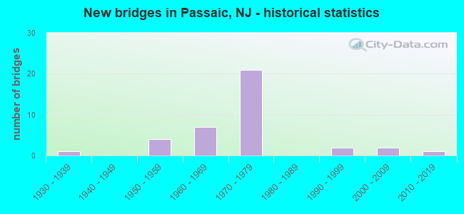
- New bridges - historical statistics
- 11930-1939
- 41950-1959
- 71960-1969
- 211970-1979
- 21990-1999
- 22000-2009
- 12010-2019
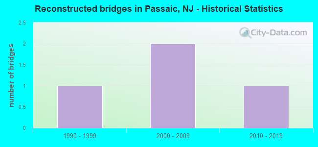
- Reconstructed bridges - Historical Statistics
- 11990-1999
- 22000-2009
- 12010-2019
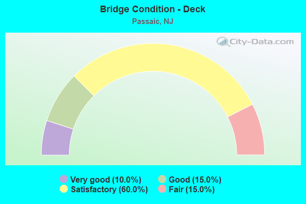
- Bridge Condition - Deck
- 10.0%Very good
- 15.0%Good
- 60.0%Satisfactory
- 15.0%Fair
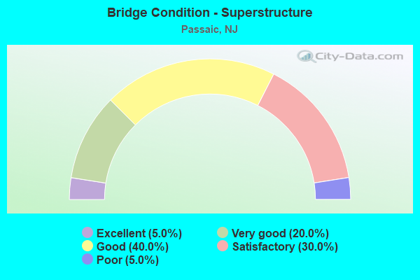
- Bridge Condition - Superstructure
- 5.0%Excellent
- 20.0%Very good
- 40.0%Good
- 30.0%Satisfactory
- 5.0%Poor
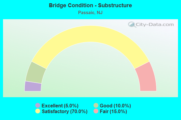
- Bridge Condition - Substructure
- 5.0%Excellent
- 10.0%Good
- 70.0%Satisfactory
- 15.0%Fair
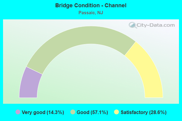
- Bridge Condition - Channel
- 14.3%Very good
- 57.1%Good
- 28.6%Satisfactory
Find on map >> Show street view
Structure Number: 1600003, Location: 0.1 MI S OF PASSAIC AVE (Lat: 40.859569, Lng: -74.116019), Route carried "on" structure: County highway 619, Year Built: 1930, Year Reconstructed: 2001, Status: Open, Structure Length: 9.45m (31.00ft), Average Daily Traffic: 15,994 (year 2021), Truck Traffic: 4%, Average Future Daily Traffic: 19,516 (year 2041), Design Load: HS 20+Mod, Features Intersected: PASSAIC RIVER, Facility Carried by Structure: MARKET STREET
Minimum Vertical Clearance: 30+ m (98+ ft), Kilometerpoint: 0.000, Lanes on structure: 2, Owner: County Highway Agency, Approaching Roadway Width: 9.1m (29.9ft), Material/Design: Steel, Design/Construction: Stringer/Multi-beam, Number Of Spans In Main Unit: 1, Number Of Approach Spans: 2, Length of Maximum Span: 36.3m (119.1ft), Curb or Sidewalk Widths: Left: 2.9m (9.5ft), Right: 2.9m (9.5ft), Curb-To-Curb Width: 9.1m (29.9ft), Out-to-Out Width: 15.8m (51.8ft)
Condition: Deck: Good, Superstructure: Satisfactory, Substructure: Satisfactory, Channel: Good, Operating Rating: 70.8 metric tons, Method Used To Determine Operating Rating: Load Factor (LF), Inventory Rating: 42.6 metric tons, Method Used To Determine Inventory Rating: Load Factor (LF), Structural Evaluation: Equal to present minimum criteria, Deck Geometry: Meets minimum limits, Waterway Adequacy: Equal to present desirable criteria, Approach Roadway Alignment: Equal to present minimum criteria, Designated Inspection Frequency: Every 24 months, Critical Feature Inspection Frequency: Every 24 months, Underwater Inspection Frequency: Every 48 months, Inspection Date: April 2021, Critical Feature Inspection Date: April 2021, Underwater Inspection Date: June 2021, Deck Structure Type: Concrete Cast-file-Place, Wearing Surface/Protective System: Wearing Surface: Monolithic Concrete, Deck Protection: Epoxy Coated Reinforcing
Find on map >> Show street view
Structure Number: 1600004, Location: 0.5 MI S. OF PASSAIC ST. (Lat: 40.854931, Lng: -74.109511), Route carried "on" structure: City street , Year Built: 2019, Status: Open, Structure Length: 8.69m (28.51ft), Average Daily Traffic: 6,825 (year 2021), Truck Traffic: 3%, Average Future Daily Traffic: 8,328 (year 2041), Design Load: HL 93, Features Intersected: PASSAIC RIVER, Facility Carried by Structure: EIGHTH ST
Minimum Vertical Clearance: 30+ m (98+ ft), Kilometerpoint: 0.950, Lanes on structure: 3, Owner: County Highway Agency, Approaching Roadway Width: 11.0m (36.1ft), Navigation Control: Yes ( Vertical Clearance: 1.8m (5.9ft), Horizontal Clearance: 42.7m (140.1ft)), Material/Design: Steel, Design/Construction: Stringer/Multi-beam, Number Of Spans In Main Unit: 2, Length of Maximum Span: 43.3m (142.1ft), Curb or Sidewalk Widths: Left: 1.8m (5.9ft), Right: 1.8m (5.9ft), Curb-To-Curb Width: 14.6m (47.9ft), Out-to-Out Width: 19.3m (63.3ft)
Condition: Deck: Very good, Superstructure: Excellent, Substructure: Excellent, Channel: Good, Operating Rating: 57.3 metric tons, Method Used To Determine Operating Rating: Load and Resistance Factor Rating (LRFR) rating reported by rating factor(RF) method using HL-93 loadings, Inventory Rating: 44.4 metric tons, Method Used To Determine Inventory Rating: Load and Resistance Factor Rating (LRFR) rating reported by rating factor(RF) method using HL-93 loadings, Structural Evaluation: Superior to present desirable criteria, Deck Geometry: Somewhat better than minimum adequacy, Waterway Adequacy: Better than present minimum criteria, Approach Roadway Alignment: Equal to present minimum criteria, Length Of Structure Improvement: 9.81m (32.19ft), Designated Inspection Frequency: Every 24 months, Underwater Inspection Frequency: Every 48 months, Inspection Date: June 2021, Underwater Inspection Date: June 2019, Bridge Improvement Cost: $4,391,000, Roadway Improvement Cost: $100,000, Total Project Cost: $7,435,000 ( Estimate for 2017), Deck Structure Type: Concrete Cast-file-Place, Wearing Surface/Protective System: Deck Protection: Epoxy Coated Reinforcing
Find on map >> Show street view
Structure Number: 1600052, Location: 0.25 MI NW OF JCT.RT.21 (Lat: 40.872600, Lng: -74.122289), Route carried "on" structure: County highway 629, Year Built: 1950, Status: Open, Structure Length: 0.98m (3.22ft), Average Daily Traffic: 6,070 (year 2021), Truck Traffic: 4%, Average Future Daily Traffic: 8,180 (year 2041), Features Intersected: WEASEL BROOK
Minimum Vertical Clearance: 30+ m (98+ ft), Kilometerpoint: 0.644, Lanes on structure: 2, Owner: County Highway Agency, Approaching Roadway Width: 12.2m (40.0ft), Skew: 2 degrees, Material/Design: Concrete continuous, Design/Construction: Slab, Number Of Spans In Main Unit: 2, Length of Maximum Span: 4.6m (15.1ft), Curb or Sidewalk Widths: Left: 3.9m (12.8ft), Right: 2.1m (6.9ft), Curb-To-Curb Width: 12.2m (40.0ft), Out-to-Out Width: 20.0m (65.6ft)
Condition: Deck: Satisfactory, Superstructure: Satisfactory, Substructure: Satisfactory, Channel: Very good, Operating Rating: 75.3 metric tons, Method Used To Determine Operating Rating: Load Factor (LF), Inventory Rating: 44.5 metric tons, Method Used To Determine Inventory Rating: Load Factor (LF), Structural Evaluation: Equal to present minimum criteria, Deck Geometry: Somewhat better than minimum adequacy, Waterway Adequacy: Superior to present desirable criteria, Approach Roadway Alignment: Equal to present desirable criteria, Designated Inspection Frequency: Every 24 months, Inspection Date: April 2021, Deck Structure Type: Concrete Cast-file-Place, Wearing Surface/Protective System: Wearing Surface: Bituminous
Find on map >> Show street view
Structure Number: 1600053, Location: 0.3 E OF LEXINGTON AV/625 (Lat: 40.872931, Lng: -74.123581), Route carried "on" structure: City street , Year Built: 1951, Year Reconstructed: 2010, Status: Open, Structure Length: 1.25m (4.10ft), Average Daily Traffic: 2,460 (year 2021), Truck Traffic: 1%, Average Future Daily Traffic: 3,320 (year 2041), Design Load: HS 25 or greater, Features Intersected: WEASEL BROOK, Facility Carried by Structure: PRESIDENT STREET
Minimum Vertical Clearance: 30+ m (98+ ft), Kilometerpoint: 0.000, Lanes on structure: 2, Owner: County Highway Agency, Approaching Roadway Width: 12.5m (41.0ft), Skew: 4 degrees, Material/Design: Concrete continuous, Design/Construction: Slab, Number Of Spans In Main Unit: 2, Length of Maximum Span: 6.1m (20.0ft), Curb or Sidewalk Widths: Left: 4.2m (13.8ft), Right: 4.2m (13.8ft), Curb-To-Curb Width: 12.4m (40.7ft), Out-to-Out Width: 20.7m (67.9ft)
Condition: Deck: Satisfactory, Superstructure: Satisfactory, Substructure: Satisfactory, Channel: Satisfactory, Inventory Rating: 54.4 metric tons, Method Used To Determine Inventory Rating: Load Factor (LF), Structural Evaluation: Equal to present minimum criteria, Deck Geometry: Equal to present minimum criteria, Waterway Adequacy: Superior to present desirable criteria, Approach Roadway Alignment: Equal to present desirable criteria, Designated Inspection Frequency: Every 24 months, Inspection Date: April 2021, Deck Structure Type: Concrete Cast-file-Place, Wearing Surface/Protective System: Deck Protection: Galvanized Reinforcing
Find on map >> Show street view
Structure Number: 1600054, Location: 200FT S OF HIGHLND AV/626 (Lat: 40.873131, Lng: -74.124481), Route carried "on" structure: City street , Year Built: 1952, Year Reconstructed: 2008, Status: Open, Structure Length: 1.34m (4.40ft), Average Daily Traffic: 2,510 (year 2021), Truck Traffic: 5%, Average Future Daily Traffic: 3,390 (year 2041), Design Load: HS 25 or greater, Features Intersected: WEASEL BROOK, Facility Carried by Structure: VAN WINKLE AVENUE
Minimum Vertical Clearance: 30+ m (98+ ft), Kilometerpoint: 0.000, Lanes on structure: 2, Owner: County Highway Agency, Approaching Roadway Width: 10.1m (33.1ft), Skew: 5 degrees, Material/Design: Steel, Design/Construction: Stringer/Multi-beam, Number Of Spans In Main Unit: 1, Length of Maximum Span: 11.0m (36.1ft), Curb or Sidewalk Widths: Left: 3.2m (10.5ft), Right: 3.2m (10.5ft), Curb-To-Curb Width: 10.2m (33.5ft), Out-to-Out Width: 17.1m (56.1ft)
Condition: Deck: Good, Superstructure: Very good, Substructure: Satisfactory, Channel: Good, Inventory Rating: 80.7 metric tons, Method Used To Determine Inventory Rating: Load Factor (LF), Structural Evaluation: Equal to present minimum criteria, Deck Geometry: Meets minimum limits, Waterway Adequacy: Superior to present desirable criteria, Approach Roadway Alignment: Equal to present desirable criteria, Designated Inspection Frequency: Every 24 months, Inspection Date: April 2021, Deck Structure Type: Closed Grating, Wearing Surface/Protective System: Wearing Surface: Monolithic Concrete, Deck Protection: Galvanized Reinforcing
Find on map >> Show street view
Structure Number: 1600055, Location: 0.22 E OF LEXINGTON AV (Lat: 40.873519, Lng: -74.125681), Route carried "on" structure: County highway 626, Year Built: 1952, Year Reconstructed: 2007, Status: Open, Structure Length: 0.82m (2.69ft), Average Daily Traffic: 4,815 (year 2021), Truck Traffic: 1%, Average Future Daily Traffic: 6,490 (year 2041), Design Load: HS 25 or greater, Features Intersected: WEASEL BROOK
Minimum Vertical Clearance: 30+ m (98+ ft), Kilometerpoint: 0.338, Lanes on structure: 2, Owner: County Highway Agency, Approaching Roadway Width: 11.0m (36.1ft), Material/Design: Steel, Design/Construction: Stringer/Multi-beam, Number Of Spans In Main Unit: 1, Length of Maximum Span: 6.7m (22.0ft), Curb or Sidewalk Widths: Left: 3.2m (10.5ft), Right: 3.4m (11.2ft), Curb-To-Curb Width: 10.9m (35.8ft), Out-to-Out Width: 18.2m (59.7ft)
Condition: Deck: Good, Superstructure: Very good, Substructure: Good, Channel: Satisfactory, Inventory Rating: 74.4 metric tons, Method Used To Determine Inventory Rating: Load Factor (LF), Structural Evaluation: Better than present minimum criteria, Deck Geometry: Somewhat better than minimum adequacy, Waterway Adequacy: Superior to present desirable criteria, Approach Roadway Alignment: Equal to present desirable criteria, Designated Inspection Frequency: Every 24 months, Inspection Date: April 2021, Deck Structure Type: Closed Grating, Wearing Surface/Protective System: Wearing Surface: Monolithic Concrete, Deck Protection: Galvanized Reinforcing
Find on map >> Show street view
Structure Number: 1603163, Location: 1.1 MI N OF 3-21 JCT (Lat: 40.838431, Lng: -74.125150), Route carried "on" structure: State highway 21, Year Built: 1967, Status: Open, Structure Length: 5.91m (19.39ft), Average Daily Traffic: 44,672 (year 2021), Truck Traffic: 5%, Average Future Daily Traffic: 56,287 (year 2041), Design Load: HS 20+Mod, Features Intersected: BROOK AVE,RIVER DR NB
Minimum Vertical Clearance: 30+ m (98+ ft), Kilometerpoint: 16.721, Lanes on structure: 7, Lanes under structure: 2, Base Highway Network: Yes, Owner: State Highway Agency, Approaching Roadway Width: 34.1m (111.9ft), Skew: 33 degrees, Material/Design: Steel, Design/Construction: Stringer/Multi-beam, Number Of Spans In Main Unit: 3, Length of Maximum Span: 30.2m (99.1ft), Curb or Sidewalk Widths: Left: 0.5m (1.6ft), Right: 0.5m (1.6ft), Curb-To-Curb Width: 34.1m (111.9ft), Out-to-Out Width: 36.3m (119.1ft)
Condition: Deck: Satisfactory, Superstructure: Poor, Substructure: Satisfactory, Operating Rating: 41.7 metric tons, Method Used To Determine Operating Rating: Load Factor (LF), Inventory Rating: 25.4 metric tons, Method Used To Determine Inventory Rating: Load Factor (LF), Structural Evaluation: Meets minimum limits, Deck Geometry: Superior to present desirable criteria, Underclear: Meets minimum limits, Approach Roadway Alignment: Equal to present desirable criteria, Length Of Structure Improvement: 7.01m (23.00ft), Designated Inspection Frequency: Every 24 months, Critical Feature Inspection Frequency: Every 24 months, Inspection Date: March 2021, Critical Feature Inspection Date: March 2021, Bridge Improvement Cost: $15,045,000, Roadway Improvement Cost: $300,000, Total Project Cost: $23,246,000 ( Estimate for 2021), Deck Structure Type: Concrete Cast-file-Place, Wearing Surface/Protective System: Wearing Surface: Monolithic Concrete
Find on map >> Show street view
Structure Number: 1603166, Location: 1.6 MI N OF NJ 3 (Lat: 40.843681, Lng: -74.122850), Route carried "on" structure: County highway 624, Year Built: 1967, Status: Open, Structure Length: 5.91m (19.39ft), Average Daily Traffic: 8,344 (year 2021), Truck Traffic: 3%, Average Future Daily Traffic: 10,013 (year 2041), Design Load: HS 20+Mod, Features Intersected: NJ ROUTE 21, Facility Carried by Structure: VAN HOUTEN&RIV DR
Minimum Vertical Clearance: 30+ m (98+ ft), Kilometerpoint: 3.380, Lanes on structure: 2, Lanes under structure: 7, Owner: State Highway Agency, Approaching Roadway Width: 9.1m (29.9ft), Skew: 34 degrees, Material/Design: Steel, Design/Construction: Stringer/Multi-beam, Number Of Spans In Main Unit: 2, Length of Maximum Span: 30.8m (101.0ft), Curb or Sidewalk Widths: Left: 0.8m (2.6ft), Right: 2.4m (7.9ft), Curb-To-Curb Width: 9.1m (29.9ft), Out-to-Out Width: 13.0m (42.7ft)
Condition: Deck: Satisfactory, Superstructure: Good, Substructure: Satisfactory, Operating Rating: 52.6 metric tons, Method Used To Determine Operating Rating: Load Factor (LF), Inventory Rating: 31.8 metric tons, Method Used To Determine Inventory Rating: Load Factor (LF), Structural Evaluation: Equal to present minimum criteria, Deck Geometry: Meets minimum limits, Underclear: High priority of corrective action, Approach Roadway Alignment: Somewhat better than minimum adequacy, Length Of Structure Improvement: 5.91m (19.39ft), Designated Inspection Frequency: Every 24 months, Critical Feature Inspection Frequency: Every 24 months, Inspection Date: Febuary 2021, Critical Feature Inspection Date: Febuary 2021, Bridge Improvement Cost: $1,027,000, Roadway Improvement Cost: $111,000, Total Project Cost: $1,502,000 ( Estimate for 2021), Deck Structure Type: Concrete Cast-file-Place, Wearing Surface/Protective System: Wearing Surface: Monolithic Concrete
Find on map >> Show street view
Structure Number: 1603167, Location: 2.0 MI N OF NJ 3 (Lat: 40.850969, Lng: -74.121381), Route carried "on" structure: State highway 21, Year Built: 1967, Status: Open, Structure Length: 4.85m (15.91ft), Average Daily Traffic: 74,699 (year 2021), Truck Traffic: 5%, Average Future Daily Traffic: 89,639 (year 2041), Design Load: HS 20+Mod, Features Intersected: RIVER DRIVE (CR 624 II)
Minimum Vertical Clearance: 30+ m (98+ ft), Kilometerpoint: 18.137, Lanes on structure: 7, Lanes under structure: 2, Base Highway Network: Yes, Owner: State Highway Agency, Approaching Roadway Width: 31.1m (102.0ft), Skew: 36 degrees, Material/Design: Steel, Design/Construction: Stringer/Multi-beam, Number Of Spans In Main Unit: 1, Length of Maximum Span: 43.6m (143.0ft), Curb or Sidewalk Widths: Left: 0.8m (2.6ft), Right: 0.5m (1.6ft), Curb-To-Curb Width: 31.1m (102.0ft), Out-to-Out Width: 33.5m (109.9ft)
Condition: Deck: Satisfactory, Superstructure: Satisfactory, Substructure: Fair, Operating Rating: 78.9 metric tons, Method Used To Determine Operating Rating: Load Factor (LF), Inventory Rating: 47.2 metric tons, Method Used To Determine Inventory Rating: Load Factor (LF), Structural Evaluation: Somewhat better than minimum adequacy, Deck Geometry: Equal to present minimum criteria, Underclear: Meets minimum limits, Approach Roadway Alignment: Better than present minimum criteria, Designated Inspection Frequency: Every 24 months, Critical Feature Inspection Frequency: Every 24 months, Inspection Date: March 2021, Critical Feature Inspection Date: March 2021, Deck Structure Type: Concrete Cast-file-Place, Wearing Surface/Protective System: Wearing Surface: Monolithic Concrete
Find on map >> Show street view
Structure Number: 1603168, Location: 0.07 mi N of CR 624 II (Lat: 40.852569, Lng: -74.121781), Route carried "on" structure: County highway 618, Year Built: 1972, Status: Open, Structure Length: 6.19m (20.31ft), Average Daily Traffic: 9,720 (year 2021), Truck Traffic: 4%, Average Future Daily Traffic: 11,664 (year 2041), Design Load: HS 20+Mod, Features Intersected: NJ ROUTE 21 & RAMP H
Minimum Vertical Clearance: 30+ m (98+ ft), Kilometerpoint: 0.113, Lanes on structure: 2, Lanes under structure: 7, Owner: State Highway Agency, Approaching Roadway Width: 14.6m (47.9ft), Skew: 4 degrees, Material/Design: Steel, Design/Construction: Stringer/Multi-beam, Number Of Spans In Main Unit: 2, Length of Maximum Span: 34.1m (111.9ft), Curb or Sidewalk Widths: Left: 2.4m (7.9ft), Right: 2.4m (7.9ft), Curb-To-Curb Width: 14.6m (47.9ft), Out-to-Out Width: 20.1m (65.9ft)
Condition: Deck: Satisfactory, Superstructure: Good, Substructure: Satisfactory, Operating Rating: 47.2 metric tons, Method Used To Determine Operating Rating: Load Factor (LF), Inventory Rating: 28.1 metric tons, Method Used To Determine Inventory Rating: Load Factor (LF), Structural Evaluation: Equal to present minimum criteria, Deck Geometry: Superior to present desirable criteria, Underclear: High priority of corrective action, Approach Roadway Alignment: Equal to present minimum criteria, Length Of Structure Improvement: 6.19m (20.31ft), Designated Inspection Frequency: Every 24 months, Critical Feature Inspection Frequency: Every 24 months, Inspection Date: Febuary 2021, Critical Feature Inspection Date: Febuary 2021, Bridge Improvement Cost: $847,000, Roadway Improvement Cost: $182,000, Total Project Cost: $1,366,000 ( Estimate for 2021), Deck Structure Type: Concrete Cast-file-Place, Wearing Surface/Protective System: Wearing Surface: Monolithic Concrete
Find on map >> Show street view
Structure Number: 1603169, Location: 2.3 MI N OF 3-21 JCT (Lat: 40.854750, Lng: -74.122250), Route carried "on" structure: City street , Year Built: 1972, Status: Open, Structure Length: 6.34m (20.80ft), Average Daily Traffic: 13,702 (year 2021), Truck Traffic: 4%, Average Future Daily Traffic: 16,442 (year 2041), Design Load: HS 20+Mod, Features Intersected: NJ ROUTE 21 & RAMP K, Facility Carried by Structure: GREGORY AVE
Minimum Vertical Clearance: 30+ m (98+ ft), Kilometerpoint: 2.140, Lanes on structure: 3, Lanes under structure: 8, Owner: State Highway Agency, Approaching Roadway Width: 14.6m (47.9ft), Skew: 3 degrees, Material/Design: Steel, Design/Construction: Stringer/Multi-beam, Number Of Spans In Main Unit: 2, Length of Maximum Span: 30.5m (100.1ft), Curb or Sidewalk Widths: Left: 2.4m (7.9ft), Right: 2.4m (7.9ft), Curb-To-Curb Width: 14.6m (47.9ft), Out-to-Out Width: 20.1m (65.9ft)
Condition: Deck: Satisfactory, Superstructure: Good, Substructure: Satisfactory, Operating Rating: 75.3 metric tons, Method Used To Determine Operating Rating: Load Factor (LF), Inventory Rating: 45.4 metric tons, Method Used To Determine Inventory Rating: Load Factor (LF), Structural Evaluation: Equal to present minimum criteria, Deck Geometry: Somewhat better than minimum adequacy, Underclear: High priority of corrective action, Approach Roadway Alignment: Equal to present minimum criteria, Length Of Structure Improvement: 6.34m (20.80ft), Designated Inspection Frequency: Every 24 months, Inspection Date: Febuary 2021, Bridge Improvement Cost: $852,000, Roadway Improvement Cost: $110,000, Total Project Cost: $1,223,000 ( Estimate for 2021), Deck Structure Type: Concrete Cast-file-Place, Wearing Surface/Protective System: Wearing Surface: Monolithic Concrete
Find on map >> Show street view
Structure Number: 160317, Location: 2.4 MI N OF 3-21 JCT (Lat: 40.856081, Lng: -74.121800), Route carried "on" structure: County highway 624, Year Built: 1972, Status: Open, Structure Length: 7.50m (24.61ft), Average Daily Traffic: 4,967 (year 2021), Truck Traffic: 3%, Average Future Daily Traffic: 5,960 (year 2041), Design Load: HS 20+Mod, Features Intersected: N.J ROUTE 21&RAMPS J&K, Facility Carried by Structure: RIVER DRIVE
Minimum Vertical Clearance: 30+ m (98+ ft), Kilometerpoint: 4.812, Lanes on structure: 2, Lanes under structure: 8, Owner: State Highway Agency, Approaching Roadway Width: 7.9m (25.9ft), Skew: 2 degrees, Material/Design: Steel, Design/Construction: Stringer/Multi-beam, Number Of Spans In Main Unit: 3, Length of Maximum Span: 30.5m (100.1ft), Curb or Sidewalk Widths: Left: 2.4m (7.9ft), Right: 2.4m (7.9ft), Curb-To-Curb Width: 7.9m (25.9ft), Out-to-Out Width: 13.4m (44.0ft)
Condition: Deck: Satisfactory, Superstructure: Good, Substructure: Satisfactory, Operating Rating: 72.6 metric tons, Method Used To Determine Operating Rating: Load Factor (LF), Inventory Rating: 43.5 metric tons, Method Used To Determine Inventory Rating: Load Factor (LF), Structural Evaluation: Equal to present minimum criteria, Deck Geometry: High priority of replacement, Underclear: High priority of corrective action, Approach Roadway Alignment: Equal to present minimum criteria, Length Of Structure Improvement: 7.50m (24.61ft), Designated Inspection Frequency: Every 24 months, Inspection Date: Febuary 2021, Bridge Improvement Cost: $1,318,000, Roadway Improvement Cost: $137,000, Total Project Cost: $2,008,000 ( Estimate for 2021), Deck Structure Type: Concrete Cast-file-Place, Wearing Surface/Protective System: Wearing Surface: Monolithic Concrete
Find on map >> Show street view
Structure Number: 1603171, Location: 2.46 MI N OF NJ 3-21 JCT (Lat: 40.857139, Lng: -74.121139), Route carried "on" structure: Ramp City street , Year Built: 1973, Status: Open, Structure Length: 5.27m (17.29ft), Average Daily Traffic: 6,064 (year 2021), Truck Traffic: 3%, Average Future Daily Traffic: 7,400 (year 2041), Design Load: HS 20, Features Intersected: NJ 21, Facility Carried by Structure: STATE STREET EXT
Minimum Vertical Clearance: 30+ m (98+ ft), Kilometerpoint: 0.000, Lanes on structure: 1, Lanes under structure: 6, Owner: State Highway Agency, Approaching Roadway Width: 7.9m (25.9ft), Skew: 3 degrees, Material/Design: Steel continuous, Design/Construction: Stringer/Multi-beam, Number Of Spans In Main Unit: 2, Length of Maximum Span: 25.3m (83.0ft), Curb or Sidewalk Widths: Left: 1.1m (3.6ft), Right: 1.1m (3.6ft), Curb-To-Curb Width: 8.0m (26.2ft), Out-to-Out Width: 10.7m (35.1ft)
Condition: Deck: Satisfactory, Superstructure: Good, Substructure: Satisfactory, Inventory Rating: 66.2 metric tons, Method Used To Determine Inventory Rating: Load Factor (LF), Structural Evaluation: Equal to present minimum criteria, Deck Geometry: Superior to present desirable criteria, Underclear: High priority of corrective action, Approach Roadway Alignment: Better than present minimum criteria, Length Of Structure Improvement: 5.30m (17.39ft), Designated Inspection Frequency: Every 24 months, Inspection Date: July 2021, Bridge Improvement Cost: $269,000, Roadway Improvement Cost: $61,000, Total Project Cost: $438,000 ( Estimate for 2021), Deck Structure Type: Concrete Cast-file-Place, Wearing Surface/Protective System: Wearing Surface: Monolithic Concrete
Find on map >> Show street view
Structure Number: 1603172, Location: 2.8 MI N OF 3-21 JCT (Lat: 40.859231, Lng: -74.119769), Route carried "on" structure: State highway 21, Year Built: 1972, Status: Open, Structure Length: 30.24m (99.21ft), Average Daily Traffic: 71,000 (year 2020), Truck Traffic: 5%, Average Future Daily Traffic: 86,630 (year 2040), Design Load: HS 20, Features Intersected: PASSAIC ST.&WEASEL BROOK
Minimum Vertical Clearance: 30+ m (98+ ft), Kilometerpoint: 19.425, Lanes on structure: 6, Lanes under structure: 2, Base Highway Network: Yes, Owner: State Highway Agency, Approaching Roadway Width: 31.7m (104.0ft), Skew: 39 degrees, Material/Design: Steel, Design/Construction: Stringer/Multi-beam, Number Of Spans In Main Unit: 1, Number Of Approach Spans: 14, Length of Maximum Span: 23.8m (78.1ft), Curb or Sidewalk Widths: Left: 0.7m (2.3ft), Right: 0.7m (2.3ft), Curb-To-Curb Width: 31.7m (104.0ft), Out-to-Out Width: 33.2m (108.9ft)
Condition: Deck: Fair, Superstructure: Satisfactory, Substructure: Fair, Channel: Good, Operating Rating: 83.5 metric tons, Method Used To Determine Operating Rating: Load Factor (LF), Inventory Rating: 30.8 metric tons, Method Used To Determine Inventory Rating: Load Factor (LF), Structural Evaluation: Somewhat better than minimum adequacy, Deck Geometry: Superior to present desirable criteria, Underclear: Equal to present minimum criteria, Waterway Adequacy: Superior to present desirable criteria, Approach Roadway Alignment: Better than present minimum criteria, Designated Inspection Frequency: Every 24 months, Underwater Inspection Frequency: Every 48 months, Inspection Date: July 2020, Underwater Inspection Date: October 2020, Deck Structure Type: Concrete Cast-file-Place, Wearing Surface/Protective System: Wearing Surface: Monolithic Concrete, Deck Protection: Epoxy Coated Reinforcing
Find on map >> Show street view
Structure Number: 1603173, Location: 2.88 MI N OF NJ 3 (Lat: 40.862919, Lng: -74.120950), Route carried "on" structure: State highway 21, Year Built: 1972, Status: Open, Structure Length: 1.89m (6.20ft), Average Daily Traffic: 74,699 (year 2021), Truck Traffic: 5%, Average Future Daily Traffic: 89,639 (year 2041), Design Load: HS 20+Mod, Features Intersected: WASHINGTON PLACE
Minimum Vertical Clearance: 30+ m (98+ ft), Kilometerpoint: 19.570, Lanes on structure: 6, Lanes under structure: 2, Base Highway Network: Yes, Owner: State Highway Agency, Approaching Roadway Width: 31.1m (102.0ft), Skew: 30 degrees, Material/Design: Steel, Design/Construction: Stringer/Multi-beam, Number Of Spans In Main Unit: 1, Length of Maximum Span: 17.7m (58.1ft), Curb or Sidewalk Widths: Left: 0.5m (1.6ft), Right: 0.0m, Curb-To-Curb Width: 31.1m (102.0ft), Out-to-Out Width: 33.2m (108.9ft)
Condition: Deck: Fair, Superstructure: Good, Substructure: Satisfactory, Operating Rating: 89.8 metric tons, Method Used To Determine Operating Rating: Load Factor (LF), Inventory Rating: 53.5 metric tons, Method Used To Determine Inventory Rating: Load Factor (LF), Structural Evaluation: Equal to present minimum criteria, Deck Geometry: Superior to present desirable criteria, Underclear: Equal to present minimum criteria, Approach Roadway Alignment: Equal to present desirable criteria, Designated Inspection Frequency: Every 24 months, Inspection Date: March 2021, Deck Structure Type: Concrete Cast-file-Place, Wearing Surface/Protective System: Wearing Surface: Monolithic Concrete
Find on map >> Show street view
Structure Number: 1603174, Location: 2.95 MI N OF NJ 3 (Lat: 40.863839, Lng: -74.121361), Route carried "on" structure: State highway 21, Year Built: 1972, Status: Open, Structure Length: 2.04m (6.69ft), Average Daily Traffic: 74,699 (year 2021), Truck Traffic: 5%, Average Future Daily Traffic: 89,639 (year 2041), Design Load: HS 20+Mod, Features Intersected: JEFFERSON ST
Minimum Vertical Clearance: 30+ m (98+ ft), Kilometerpoint: 19.682, Lanes on structure: 6, Lanes under structure: 2, Base Highway Network: Yes, Owner: State Highway Agency, Approaching Roadway Width: 31.1m (102.0ft), Skew: 32 degrees, Material/Design: Steel, Design/Construction: Stringer/Multi-beam, Number Of Spans In Main Unit: 1, Length of Maximum Span: 19.2m (63.0ft), Curb or Sidewalk Widths: Left: 0.5m (1.6ft), Right: 0.0m, Curb-To-Curb Width: 31.1m (102.0ft), Out-to-Out Width: 33.2m (108.9ft)
Condition: Deck: Fair, Superstructure: Good, Substructure: Good, Operating Rating: 89.8 metric tons, Method Used To Determine Operating Rating: Load Factor (LF), Inventory Rating: 53.5 metric tons, Method Used To Determine Inventory Rating: Load Factor (LF), Structural Evaluation: Better than present minimum criteria, Deck Geometry: Superior to present desirable criteria, Underclear: Equal to present minimum criteria, Approach Roadway Alignment: Better than present minimum criteria, Designated Inspection Frequency: Every 24 months, Inspection Date: March 2021, Deck Structure Type: Concrete Cast-file-Place, Wearing Surface/Protective System: Wearing Surface: Monolithic Concrete
Find on map >> Show street view
Structure Number: 1603175, Location: 3.04 MI N OF NJ 3 (Lat: 40.864900, Lng: -74.121281), Route carried "on" structure: State highway 21, Year Built: 1972, Status: Open, Structure Length: 2.71m (8.89ft), Average Daily Traffic: 74,699 (year 2021), Truck Traffic: 5%, Average Future Daily Traffic: 89,639 (year 2041), Design Load: HS 20+Mod, Features Intersected: MADISON ST
Minimum Vertical Clearance: 30+ m (98+ ft), Kilometerpoint: 19.827, Lanes on structure: 6, Lanes under structure: 2, Base Highway Network: Yes, Owner: State Highway Agency, Approaching Roadway Width: 31.1m (102.0ft), Skew: 34 degrees, Material/Design: Steel, Design/Construction: Stringer/Multi-beam, Number Of Spans In Main Unit: 1, Length of Maximum Span: 25.6m (84.0ft), Curb or Sidewalk Widths: Left: 0.5m (1.6ft), Right: 0.5m (1.6ft), Curb-To-Curb Width: 31.1m (102.0ft), Out-to-Out Width: 33.2m (108.9ft)
Condition: Deck: Satisfactory, Superstructure: Satisfactory, Substructure: Fair, Operating Rating: 82.6 metric tons, Method Used To Determine Operating Rating: Load Factor (LF), Inventory Rating: 49.0 metric tons, Method Used To Determine Inventory Rating: Load Factor (LF), Structural Evaluation: Somewhat better than minimum adequacy, Deck Geometry: Superior to present desirable criteria, Underclear: Better than present minimum criteria, Approach Roadway Alignment: Better than present minimum criteria, Designated Inspection Frequency: Every 24 months, Inspection Date: March 2021, Deck Structure Type: Concrete Cast-file-Place, Wearing Surface/Protective System: Wearing Surface: Monolithic Concrete
Find on map >> Show street view
Structure Number: 1603177, Location: 3.08 MI N OF NJ 3 (Lat: 40.865139, Lng: -74.121181), Route carried "on" structure: State highway 21, Year Built: 1972, Status: Open, Structure Length: 2.50m (8.20ft), Average Daily Traffic: 74,699 (year 2021), Truck Traffic: 5%, Average Future Daily Traffic: 89,639 (year 2041), Design Load: HS 20+Mod, Features Intersected: HOPE AVENUE
Minimum Vertical Clearance: 30+ m (98+ ft), Kilometerpoint: 19.875, Lanes on structure: 6, Lanes under structure: 2, Base Highway Network: Yes, Owner: State Highway Agency, Approaching Roadway Width: 41.1m (134.8ft), Skew: 33 degrees, Material/Design: Steel, Design/Construction: Stringer/Multi-beam, Number Of Spans In Main Unit: 1, Length of Maximum Span: 23.8m (78.1ft), Curb or Sidewalk Widths: Left: 0.5m (1.6ft), Right: 0.5m (1.6ft), Curb-To-Curb Width: 41.1m (134.8ft), Out-to-Out Width: 43.3m (142.1ft)
Condition: Deck: Satisfactory, Superstructure: Good, Substructure: Satisfactory, Operating Rating: 81.6 metric tons, Method Used To Determine Operating Rating: Load Factor (LF), Inventory Rating: 49.0 metric tons, Method Used To Determine Inventory Rating: Load Factor (LF), Structural Evaluation: Equal to present minimum criteria, Deck Geometry: Superior to present desirable criteria, Underclear: Equal to present minimum criteria, Approach Roadway Alignment: Better than present minimum criteria, Designated Inspection Frequency: Every 24 months, Inspection Date: March 2021, Deck Structure Type: Concrete Cast-file-Place, Wearing Surface/Protective System: Wearing Surface: Monolithic Concrete
Find on map >> Show street view
Structure Number: 1603184, Location: 1.6 MI S of US 46 JCT (Lat: 40.868731, Lng: -74.118461), Route carried "on" structure: State highway 21, Year Built: 2000, Status: Open, Structure Length: 3.32m (10.89ft), Average Daily Traffic: 74,700 (year 2021), Truck Traffic: 5%, Average Future Daily Traffic: 89,640 (year 2041), Design Load: HS 25 or greater, Features Intersected: DAYTON AVENUE
Minimum Vertical Clearance: 30+ m (98+ ft), Kilometerpoint: 20.374, Lanes on structure: 4, Lanes under structure: 3, Base Highway Network: Yes, Owner: State Highway Agency, Approaching Roadway Width: 24.8m (81.4ft), Skew: 34 degrees, Material/Design: Steel, Design/Construction: Stringer/Multi-beam, Number Of Spans In Main Unit: 1, Length of Maximum Span: 30.5m (100.1ft), Curb-To-Curb Width: 24.8m (81.4ft), Out-to-Out Width: 27.0m (88.6ft)
Condition: Deck: Very good, Superstructure: Very good, Substructure: Satisfactory, Structural Evaluation: Equal to present minimum criteria, Deck Geometry: Superior to present desirable criteria, Approach Roadway Alignment: Equal to present desirable criteria, Designated Inspection Frequency: Every 24 months, Inspection Date: March 2021, Deck Structure Type: Concrete Cast-file-Place, Wearing Surface/Protective System: Deck Protection: Epoxy Coated Reinforcing
Find on map >> Show street view
Structure Number: 1660163, Location: 4.13MI SE I-80 & NJ19 JCT (Lat: 40.854539, Lng: -74.137939), Route carried "on" structure: County highway 622, Year Built: 1992, Status: Open, Structure Length: 2.04m (6.69ft), Average Daily Traffic: 14,428 (year 2021), Truck Traffic: 4%, Average Future Daily Traffic: 17,605 (year 2041), Design Load: HS 20+Mod, Features Intersected: MAIN LINE M.P. 10.98
Minimum Vertical Clearance: 30+ m (98+ ft), Kilometerpoint: 3.187, Lanes on structure: 2, Owner: State Agenciy, Approaching Roadway Width: 8.2m (26.9ft), Material/Design: Steel, Design/Construction: Stringer/Multi-beam, Number Of Spans In Main Unit: 1, Length of Maximum Span: 19.2m (63.0ft), Curb or Sidewalk Widths: Left: 1.8m (5.9ft), Right: 1.8m (5.9ft), Curb-To-Curb Width: 8.4m (27.6ft), Out-to-Out Width: 13.4m (44.0ft)
Condition: Deck: Satisfactory, Superstructure: Very good, Substructure: Satisfactory, Operating Rating: 86.2 metric tons, Method Used To Determine Operating Rating: Load Factor (LF), Inventory Rating: 51.7 metric tons, Method Used To Determine Inventory Rating: Load Factor (LF), Structural Evaluation: Equal to present minimum criteria, Deck Geometry: High priority of replacement, Underclear: Meets minimum limits, Approach Roadway Alignment: Equal to present minimum criteria, Length Of Structure Improvement: 2.04m (6.69ft), Designated Inspection Frequency: Every 24 months, Inspection Date: Febuary 2021, Bridge Improvement Cost: $136,000, Roadway Improvement Cost: $20,000, Total Project Cost: $334,000 ( Estimate for 2021), Deck Structure Type: Concrete Cast-file-Place, Wearing Surface/Protective System: Wearing Surface: Monolithic Concrete, Deck Protection: Epoxy Coated Reinforcing
Find on map >> Show street view
Structure Number: 1603163, Location: 1.1 MI N OF 3-21 JCT (Lat: 40.838431, Lng: -74.125150), Route carried "under" structure: County highway 608, Year Built: 1967, Structure Length: 0. m, Average Daily Traffic: 7,858 (year 2021), Truck Traffic: 3%, Features Intersected: BROOK AVE,RIVER DR NB, Facility Carried by Structure: NJ RT 21 & RAMP B
Minimum Vertical Clearance: 4.60m (15.09ft), Kilometerpoint: 2.076, Lanes on structure: 7, Lanes under structure: 1, Material/Design: Steel, Design/Construction: Stringer/Multi-beam, Length of Maximum Span: 30.2m (99.1ft)
Find on map >> Show street view
Structure Number: 1603163, Location: 1.1 MI N OF 3-21 JCT (Lat: 40.838431, Lng: -74.125150), Route carried "under" structure: County highway 624, Year Built: 1967, Structure Length: 0. m, Average Daily Traffic: 4,967 (year 2021), Truck Traffic: 3%, Features Intersected: BROOK AVE,RIVER DR NB, Facility Carried by Structure: NJ RT 21 & RAMP B
Minimum Vertical Clearance: 4.55m (14.93ft), Kilometerpoint: 2.736, Lanes on structure: 7, Lanes under structure: 1, Material/Design: Steel, Design/Construction: Stringer/Multi-beam, Length of Maximum Span: 30.2m (99.1ft)
Find on map >> Show street view
Structure Number: 1603166, Location: 1.6 MI N OF NJ 3 (Lat: 40.843681, Lng: -74.122850), Route carried "under" structure: State highway 21, Year Built: 1967, Structure Length: 0. m, Average Daily Traffic: 46,906 (year 2021), Truck Traffic: 5%, Features Intersected: NJ ROUTE 21, Facility Carried by Structure: VAN HOUTEN&RIV DR
Minimum Vertical Clearance: 4.65m (15.26ft), Kilometerpoint: 17.349, Lanes on structure: 2, Lanes under structure: 7, Material/Design: Steel, Design/Construction: Stringer/Multi-beam, Length of Maximum Span: 30.8m (101.0ft)
Find on map >> Show street view
Structure Number: 1603167, Location: 2.0 MI N OF NJ 3 (Lat: 40.850969, Lng: -74.121381), Route carried "under" structure: County highway 624, Year Built: 1967, Structure Length: 0. m, Average Daily Traffic: 4,967 (year 2021), Truck Traffic: 3%, Features Intersected: RIVER DRIVE (CR 624 II), Facility Carried by Structure: NJ ROUTE 21&RAMP F
Minimum Vertical Clearance: 4.60m (15.09ft), Kilometerpoint: 4.120, Lanes on structure: 7, Lanes under structure: 2, Material/Design: Steel, Design/Construction: Stringer/Multi-beam, Length of Maximum Span: 43.6m (143.0ft)
Find on map >> Show street view
Structure Number: 1603168, Location: 0.07 mi N of CR 624 II (Lat: 40.852569, Lng: -74.121781), Route carried "under" structure: State highway 21, Year Built: 1972, Structure Length: 0. m, Average Daily Traffic: 66,837 (year 2021), Truck Traffic: 5%, Features Intersected: NJ ROUTE 21 & RAMP H, Facility Carried by Structure: PAULISON AVE CR618
Minimum Vertical Clearance: 5.00m (16.40ft), Kilometerpoint: 18.363, Lanes on structure: 2, Lanes under structure: 6, Material/Design: Steel, Design/Construction: Stringer/Multi-beam, Length of Maximum Span: 34.1m (111.9ft)
Find on map >> Show street view
Structure Number: 1603168, Location: 0.07 mi N of CR 624 II (Lat: 40.852569, Lng: -74.121781), Route carried "under" structure: Ramp State highway 21, Year Built: 1972, Structure Length: 0. m, Average Daily Traffic: 8,585 (year 2021), Truck Traffic: 5%, Features Intersected: NJ ROUTE 21 & RAMP H, Facility Carried by Structure: PAULISON AVE CR618
Minimum Vertical Clearance: 4.80m (15.75ft), Kilometerpoint: 18.363, Lanes on structure: 2, Lanes under structure: 1, Material/Design: Steel, Design/Construction: Stringer/Multi-beam, Length of Maximum Span: 34.1m (111.9ft)
Find on map >> Show street view
Structure Number: 1603169, Location: 2.3 MI N OF 3-21 JCT (Lat: 40.854750, Lng: -74.122250), Route carried "under" structure: State highway 21, Year Built: 1972, Structure Length: 0. m, Average Daily Traffic: 74,699 (year 2021), Truck Traffic: 5%, Features Intersected: NJ ROUTE 21 & RAMP K, Facility Carried by Structure: GREGORY AVE
Minimum Vertical Clearance: 4.67m (15.32ft), Kilometerpoint: 18.604, Lanes on structure: 3, Lanes under structure: 8, Material/Design: Steel, Design/Construction: Stringer/Multi-beam, Length of Maximum Span: 30.5m (100.1ft)
Find on map >> Show street view
Structure Number: 160317, Location: 2.4 MI N OF 3-21 JCT (Lat: 40.856081, Lng: -74.121800), Route carried "under" structure: Ramp State highway 21, Year Built: 1972, Structure Length: 0. m, Average Daily Traffic: 23,945 (year 2021), Truck Traffic: 5%, Features Intersected: N.J ROUTE 21&RAMPS J&K, Facility Carried by Structure: RIVER DRIVE
Minimum Vertical Clearance: 4.44m (14.57ft), Kilometerpoint: 18.765, Lanes on structure: 2, Lanes under structure: 1, Material/Design: Steel, Design/Construction: Stringer/Multi-beam, Length of Maximum Span: 30.5m (100.1ft)
Find on map >> Show street view
Structure Number: 160317, Location: 2.4 MI N OF 3-21 JCT (Lat: 40.856081, Lng: -74.121800), Route carried "under" structure: State highway 21, Year Built: 1972, Structure Length: 0. m, Average Daily Traffic: 74,699 (year 2021), Truck Traffic: 5%, Features Intersected: N.J ROUTE 21&RAMPS J&K, Facility Carried by Structure: RIVER DRIVE
Minimum Vertical Clearance: 4.88m (16.01ft), Kilometerpoint: 18.765, Lanes on structure: 2, Lanes under structure: 6, Material/Design: Steel, Design/Construction: Stringer/Multi-beam, Length of Maximum Span: 30.5m (100.1ft)
Find on map >> Show street view
Structure Number: 160317, Location: 2.4 MI N OF 3-21 JCT (Lat: 40.856081, Lng: -74.121800), Route carried "under" structure: Ramp State highway 21, Year Built: 1972, Structure Length: 0. m, Average Daily Traffic: 23,945 (year 2021), Truck Traffic: 5%, Features Intersected: N.J ROUTE 21&RAMPS J&K, Facility Carried by Structure: RIVER DRIVE
Minimum Vertical Clearance: 4.37m (14.34ft), Kilometerpoint: 18.765, Lanes on structure: 2, Lanes under structure: 1, Material/Design: Steel, Design/Construction: Stringer/Multi-beam, Length of Maximum Span: 30.5m (100.1ft)
Find on map >> Show street view
Structure Number: 1603171, Location: 2.46 MI N OF NJ 3-21 JCT (Lat: 40.857139, Lng: -74.121139), Route carried "under" structure: State highway 21, Year Built: 1973, Structure Length: 0. m, Average Daily Traffic: 75,786 (year 2021), Truck Traffic: 5%, Features Intersected: NJ 21, Facility Carried by Structure: STATE STREET EXT
Minimum Vertical Clearance: 4.90m (16.08ft), Kilometerpoint: 18.894, Lanes on structure: 1, Lanes under structure: 6, Material/Design: Steel continuous, Design/Construction: Stringer/Multi-beam, Length of Maximum Span: 25.3m (83.0ft)
Find on map >> Show street view
Structure Number: 1603172, Location: 2.8 MI N OF 3-21 JCT (Lat: 40.859231, Lng: -74.119769), Route carried "under" structure: City street , Year Built: 1972, Structure Length: 0. m, Average Daily Traffic: 20,340 (year 2020), Truck Traffic: 4%, Features Intersected: PASSAIC ST.&WEASEL BROOK, Facility Carried by Structure: ROUTE NJ 21
Minimum Vertical Clearance: 4.54m (14.90ft), Kilometerpoint: 2.462, Lanes on structure: 6, Lanes under structure: 2, Material/Design: Steel, Design/Construction: Stringer/Multi-beam, Length of Maximum Span: 23.8m (78.1ft)
Find on map >> Show street view
Structure Number: 1603173, Location: 2.88 MI N OF NJ 3 (Lat: 40.862919, Lng: -74.120950), Route carried "under" structure: City street , Year Built: 1972, Structure Length: 0. m, Average Daily Traffic: 1,363 (year 2021), Truck Traffic: 3%, Features Intersected: WASHINGTON PLACE, Facility Carried by Structure: NJ ROUTE 21
Minimum Vertical Clearance: 4.60m (15.09ft), Kilometerpoint: 0.000, Lanes on structure: 6, Lanes under structure: 2, Material/Design: Steel, Design/Construction: Stringer/Multi-beam, Length of Maximum Span: 17.7m (58.1ft)
Find on map >> Show street view
Structure Number: 1603174, Location: 2.95 MI N OF NJ 3 (Lat: 40.863839, Lng: -74.121361), Route carried "under" structure: City street , Year Built: 1972, Structure Length: 0. m, Average Daily Traffic: 2,611 (year 2021), Truck Traffic: 1%, Features Intersected: JEFFERSON ST, Facility Carried by Structure: NJ ROUTE 21
Minimum Vertical Clearance: 4.65m (15.26ft), Kilometerpoint: 0.000, Lanes on structure: 6, Lanes under structure: 2, Material/Design: Steel, Design/Construction: Stringer/Multi-beam, Length of Maximum Span: 19.2m (63.0ft)
Find on map >> Show street view
Structure Number: 1603175, Location: 3.04 MI N OF NJ 3 (Lat: 40.864900, Lng: -74.121281), Route carried "under" structure: City street , Year Built: 1972, Structure Length: 0. m, Average Daily Traffic: 926 (year 2021), Truck Traffic: 3%, Features Intersected: MADISON ST, Facility Carried by Structure: NJ ROUTE 21
Minimum Vertical Clearance: 4.98m (16.34ft), Kilometerpoint: 0.000, Lanes on structure: 6, Lanes under structure: 2, Material/Design: Steel, Design/Construction: Stringer/Multi-beam, Length of Maximum Span: 25.6m (84.0ft)
Find on map >> Show street view
Structure Number: 1603177, Location: 3.08 MI N OF NJ 3 (Lat: 40.865139, Lng: -74.121181), Route carried "under" structure: City street , Year Built: 1972, Structure Length: 0. m, Average Daily Traffic: 5,212 (year 2021), Truck Traffic: 1%, Features Intersected: HOPE AVENUE, Facility Carried by Structure: ROUTE NJ21 &RAMP N
Minimum Vertical Clearance: 4.70m (15.42ft), Kilometerpoint: 0.000, Lanes on structure: 6, Lanes under structure: 2, Material/Design: Steel, Design/Construction: Stringer/Multi-beam, Length of Maximum Span: 23.8m (78.1ft)
Find on map >> Show street view
Structure Number: 1603182, Location: 0.12 MI. N. OF MADISON ST (Lat: 40.867619, Lng: -74.119631), Route carried "under" structure: City street , Year Built: 1999, Structure Length: 0. m, Average Daily Traffic: 2,162 (year 2021), Truck Traffic: 4%, Features Intersected: MONROE ST & WEASEL BROOK, Facility Carried by Structure: ROUTE NJ 21
Minimum Vertical Clearance: 4.72m (15.49ft), Kilometerpoint: 0.933, Lanes on structure: 4, Lanes under structure: 3, Material/Design: Steel continuous, Design/Construction: Stringer/Multi-beam, Length of Maximum Span: 41.8m (137.1ft)
Find on map >> Show street view
Structure Number: 1603184, Location: 1.6 MI S of US 46 JCT (Lat: 40.868731, Lng: -74.118461), Route carried "under" structure: City street , Year Built: 2000, Structure Length: 0. m, Average Daily Traffic: 530 (year 2021), Truck Traffic: 4%, Features Intersected: DAYTON AVENUE, Facility Carried by Structure: NJ 21
Minimum Vertical Clearance: 4.75m (15.58ft), Kilometerpoint: 0.080, Lanes on structure: 4, Lanes under structure: 3, Material/Design: Steel, Design/Construction: Stringer/Multi-beam, Length of Maximum Span: 30.5m (100.1ft)