Bridge Statistics for Pella, Wisconsin (WI)
Condition, Traffic, Stress, Structural Evaluation, Project Costs
- National Bridge Inventory (NBI) Statistics
- 14Number of bridges
- 105ft / 32.3mTotal length
- 6,271Total average daily traffic
- 32Total average daily truck traffic
- 6,714Total future (year 2037) average daily traffic
- National Bridge Inventory (NBI) Registered Bridges for Pella
- No street view available for this location
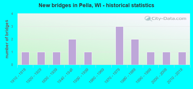
- New bridges - historical statistics
- 11910-1919
- 11920-1929
- 11930-1939
- 21940-1949
- 11950-1959
- 31970-1979
- 21980-1989
- 11990-1999
- 12000-2009
- 12010-2019
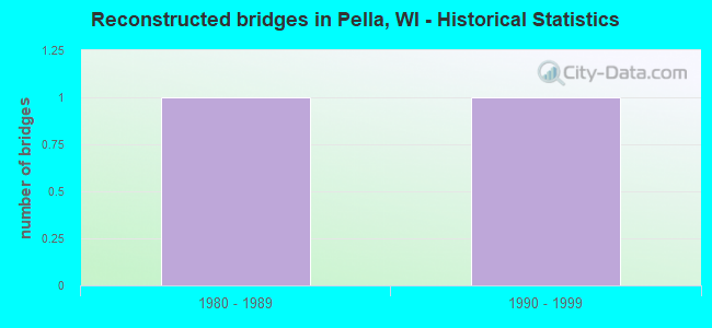
- Reconstructed bridges - Historical Statistics
- 11980-1989
- 11990-1999
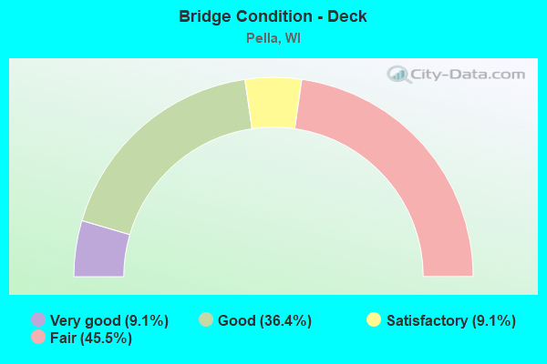
- Bridge Condition - Deck
- 9.1%Very good
- 36.4%Good
- 9.1%Satisfactory
- 45.5%Fair
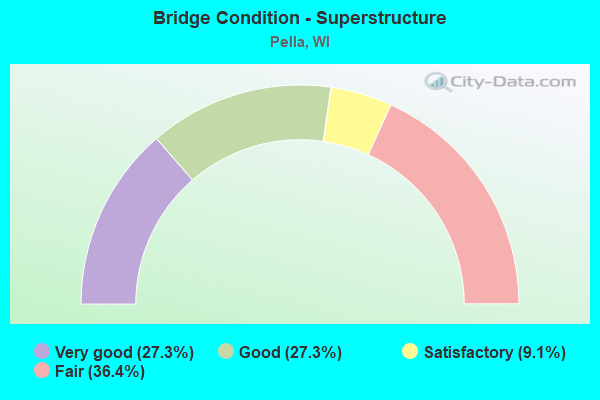
- Bridge Condition - Superstructure
- 27.3%Very good
- 27.3%Good
- 9.1%Satisfactory
- 36.4%Fair
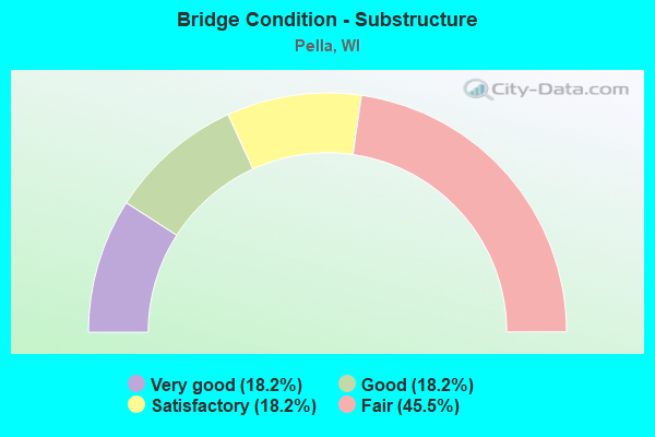
- Bridge Condition - Substructure
- 18.2%Very good
- 18.2%Good
- 18.2%Satisfactory
- 45.5%Fair
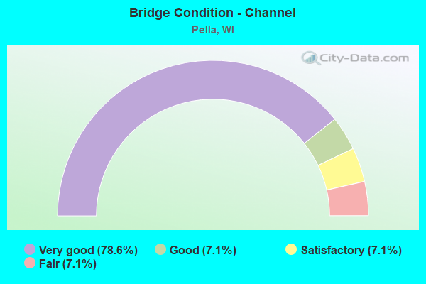
- Bridge Condition - Channel
- 78.6%Very good
- 7.1%Good
- 7.1%Satisfactory
- 7.1%Fair

- Bridge Condition - Culverts
- 33.3%Good
- 66.7%Satisfactory
Find on map >> Show street view
Structure Number: B580001, Location: 1.5M N JCT CTH E (Lat: 44.809128, Lng: -88.331569), Route carried "on" structure: County highway , Year Built: 1947, Status: Open, Structure Length: 0.94m (3.08ft), Average Daily Traffic: 638 (year 2019), Average Future Daily Traffic: 701 (year 2040), Design Load: HS 20, Features Intersected: N BR PENSAUKEE RIVER, Facility Carried by Structure: CTH C
Minimum Vertical Clearance: 30+ m (98+ ft), Kilometerpoint: 0.000, Lanes on structure: 2, Owner: County Highway Agency, Approaching Roadway Width: 9.1m (29.9ft), Material/Design: Steel, Design/Construction: Stringer/Multi-beam, Number Of Spans In Main Unit: 1, Length of Maximum Span: 9.3m (30.5ft), Curb-To-Curb Width: 7.3m (24.0ft), Out-to-Out Width: 8.1m (26.6ft)
Condition: Deck: Fair, Superstructure: Fair, Substructure: Fair, Channel: Very good, Operating Rating: 45.7 metric tons, Method Used To Determine Operating Rating: Load Factor (LF), Inventory Rating: 27.5 metric tons, Method Used To Determine Inventory Rating: Load Factor (LF), Structural Evaluation: Somewhat better than minimum adequacy, Deck Geometry: Meets minimum limits, Waterway Adequacy: Equal to present desirable criteria, Approach Roadway Alignment: Equal to present desirable criteria, Designated Inspection Frequency: Every 24 months, Inspection Date: October 2021, Deck Structure Type: Concrete Cast-file-Place, Wearing Surface/Protective System: Wearing Surface: Bituminous
Find on map >> Show street view
Structure Number: B580008, Location: 0.2M S JCT CTH M TO N (Lat: 44.740278, Lng: -88.800833), Route carried "on" structure: County highway , Year Built: 1950, Status: Open, Structure Length: 6.58m (21.59ft), Average Daily Traffic: 1,150 (year 2021), Average Future Daily Traffic: 962 (year 2040), Design Load: H 15, Features Intersected: EMBARRASS RIVER, Facility Carried by Structure: CTH D
Minimum Vertical Clearance: 30+ m (98+ ft), Kilometerpoint: 0.000, Lanes on structure: 2, Owner: County Highway Agency, Approaching Roadway Width: 9.1m (29.9ft), Skew: 4 degrees, Material/Design: Steel continuous, Design/Construction: Stringer/Multi-beam, Number Of Spans In Main Unit: 3, Length of Maximum Span: 24.4m (80.1ft), Curb-To-Curb Width: 7.3m (24.0ft), Out-to-Out Width: 8.1m (26.6ft)
Condition: Deck: Fair, Superstructure: Fair, Substructure: Satisfactory, Channel: Very good, Operating Rating: 35.9 metric tons, Method Used To Determine Operating Rating: Load Factor (LF), Inventory Rating: 21.1 metric tons, Method Used To Determine Inventory Rating: Load Factor (LF), Structural Evaluation: Somewhat better than minimum adequacy, Deck Geometry: Meets minimum limits, Waterway Adequacy: Equal to present desirable criteria, Approach Roadway Alignment: Equal to present desirable criteria, Designated Inspection Frequency: Every 24 months, Inspection Date: October 2021, Deck Structure Type: Concrete Cast-file-Place, Wearing Surface/Protective System: Wearing Surface: Monolithic Concrete
Find on map >> Show street view
Structure Number: B580035, Location: 2.8M S JCT CTH M (Lat: 44.724167, Lng: -88.736389), Route carried "on" structure: City street , Year Built: 1984, Status: Open, Structure Length: 4.16m (13.65ft), Average Daily Traffic: 154 (year 2019), Average Future Daily Traffic: 169 (year 2039), Design Load: H 20, Features Intersected: EMBARRASS RIVER, Facility Carried by Structure: LRD RANGE LINE RD
Minimum Vertical Clearance: 30+ m (98+ ft), Kilometerpoint: 0.000, Lanes on structure: 2, Owner: Town or Township Highway Agency, Approaching Roadway Width: 7.9m (25.9ft), Skew: 1 degrees, Material/Design: Prestressed concrete continuous, Design/Construction: Stringer/Multi-beam, Number Of Spans In Main Unit: 2, Length of Maximum Span: 20.4m (66.9ft), Curb-To-Curb Width: 7.3m (24.0ft), Out-to-Out Width: 7.9m (25.9ft)
Condition: Deck: Fair, Superstructure: Very good, Substructure: Very good, Channel: Very good, Operating Rating: 31.0 metric tons, Method Used To Determine Operating Rating: Load Factor (LF), Inventory Rating: 25.9 metric tons, Method Used To Determine Inventory Rating: Load Factor (LF), Structural Evaluation: Equal to present minimum criteria, Deck Geometry: Somewhat better than minimum adequacy, Waterway Adequacy: Equal to present desirable criteria, Approach Roadway Alignment: Equal to present desirable criteria, Designated Inspection Frequency: Every 24 months, Underwater Inspection Frequency: Every 60 months, Inspection Date: November 2020, Underwater Inspection Date: July 2017, Deck Structure Type: Concrete Cast-file-Place, Wearing Surface/Protective System: Wearing Surface: Monolithic Concrete, Deck Protection: Epoxy Coated Reinforcing
Find on map >> Show street view
Structure Number: B580036, Location: 0.2M W JCT CTH D (Lat: 44.751944, Lng: -88.836944), Route carried "on" structure: City street , Year Built: 1987, Status: Open, Structure Length: 2.49m (8.17ft), Average Daily Traffic: 100 (year 2019), Average Future Daily Traffic: 105 (year 2039), Design Load: H 20, Features Intersected: N BR EMBARRASS RIVER, Facility Carried by Structure: LRD N BRANCH RD
Minimum Vertical Clearance: 30+ m (98+ ft), Kilometerpoint: 0.000, Lanes on structure: 2, Owner: Town or Township Highway Agency, Approaching Roadway Width: 7.3m (24.0ft), Material/Design: Concrete continuous, Design/Construction: Slab, Number Of Spans In Main Unit: 2, Length of Maximum Span: 12.2m (40.0ft), Curb-To-Curb Width: 7.3m (24.0ft), Out-to-Out Width: 7.9m (25.9ft)
Condition: Deck: Good, Superstructure: Good, Substructure: Very good, Channel: Very good, Operating Rating: 33.0 metric tons, Method Used To Determine Operating Rating: Load Factor (LF), Inventory Rating: 19.4 metric tons, Method Used To Determine Inventory Rating: Load Factor (LF), Structural Evaluation: Somewhat better than minimum adequacy, Deck Geometry: Equal to present minimum criteria, Waterway Adequacy: Equal to present desirable criteria, Approach Roadway Alignment: Equal to present minimum criteria, Designated Inspection Frequency: Every 24 months, Inspection Date: November 2020, Deck Structure Type: Concrete Cast-file-Place, Wearing Surface/Protective System: Wearing Surface: Monolithic Concrete, Deck Protection: Epoxy Coated Reinforcing
Find on map >> Show street view
Structure Number: B580055, Location: 0.2M S JCT CTH D (Lat: 44.739444, Lng: -88.803889), Route carried "on" structure: City street , Year Built: 1995, Status: Open, Structure Length: 6.90m (22.64ft), Average Daily Traffic: 303 (year 2019), Truck Traffic: 9%, Average Future Daily Traffic: 333 (year 2039), Design Load: HS 20, Features Intersected: EMBARRASS RIVER, Facility Carried by Structure: LRD STONEY HILL RD
Minimum Vertical Clearance: 30+ m (98+ ft), Kilometerpoint: 0.000, Lanes on structure: 2, Owner: Town or Township Highway Agency, Approaching Roadway Width: 7.9m (25.9ft), Material/Design: Prestressed concrete continuous, Design/Construction: Stringer/Multi-beam, Number Of Spans In Main Unit: 2, Length of Maximum Span: 34.0m (111.5ft), Curb-To-Curb Width: 7.3m (24.0ft), Out-to-Out Width: 7.9m (25.9ft)
Condition: Deck: Good, Superstructure: Very good, Substructure: Fair, Channel: Very good, Operating Rating: 70.2 metric tons, Method Used To Determine Operating Rating: Load Factor (LF), Inventory Rating: 42.1 metric tons, Method Used To Determine Inventory Rating: Load Factor (LF), Structural Evaluation: Somewhat better than minimum adequacy, Deck Geometry: Somewhat better than minimum adequacy, Waterway Adequacy: Equal to present desirable criteria, Approach Roadway Alignment: Equal to present minimum criteria, Designated Inspection Frequency: Every 24 months, Inspection Date: September 2020, Deck Structure Type: Concrete Cast-file-Place, Wearing Surface/Protective System: Wearing Surface: Monolithic Concrete, Deck Protection: Epoxy Coated Reinforcing
Find on map >> Show street view
Structure Number: B580114, Location: 0.7M S JCT CTH D (Lat: 44.747778, Lng: -88.843056), Route carried "on" structure: City street , Year Built: 2005, Status: Open, Structure Length: 3.73m (12.24ft), Average Daily Traffic: 100 (year 2019), Truck Traffic: 5%, Average Future Daily Traffic: 101 (year 2039), Design Load: HS 20, Features Intersected: MIDDLE BR EMBARRASS R, Facility Carried by Structure: LRD HAYMAN FALLS R
Minimum Vertical Clearance: 30+ m (98+ ft), Kilometerpoint: 0.000, Lanes on structure: 2, Owner: Town or Township Highway Agency, Approaching Roadway Width: 7.9m (25.9ft), Material/Design: Prestressed concrete continuous, Design/Construction: Stringer/Multi-beam, Number Of Spans In Main Unit: 2, Length of Maximum Span: 18.3m (60.0ft), Curb-To-Curb Width: 7.9m (25.9ft), Out-to-Out Width: 8.5m (27.9ft)
Condition: Deck: Good, Superstructure: Good, Substructure: Good, Channel: Very good, Operating Rating: 60.4 metric tons, Method Used To Determine Operating Rating: Load Factor (LF), Inventory Rating: 38.9 metric tons, Method Used To Determine Inventory Rating: Load Factor (LF), Structural Evaluation: Better than present minimum criteria, Deck Geometry: Equal to present minimum criteria, Waterway Adequacy: Superior to present desirable criteria, Approach Roadway Alignment: Equal to present minimum criteria, Designated Inspection Frequency: Every 48 months, Inspection Date: November 2020, Deck Structure Type: Concrete Cast-file-Place, Wearing Surface/Protective System: Wearing Surface: Monolithic Concrete, Deck Protection: Epoxy Coated Reinforcing
Find on map >> Show street view
Structure Number: B580126, Location: 1.2 MILES E JCT USH 45 (Lat: 44.679633, Lng: -88.856656), Route carried "on" structure: City street , Year Built: 2017, Status: Open, Structure Length: 1.24m (4.07ft), Average Daily Traffic: 795 (year 2019), Average Future Daily Traffic: 1,010 (year 2037), Design Load: HL 93, Features Intersected: HYDES CREEK, Facility Carried by Structure: LRD PELLA SWAMP RO
Minimum Vertical Clearance: 30+ m (98+ ft), Kilometerpoint: 0.000, Lanes on structure: 2, Owner: Town or Township Highway Agency, Approaching Roadway Width: 7.6m (24.9ft), Skew: 3 degrees, Material/Design: Concrete, Design/Construction: Slab, Number Of Spans In Main Unit: 1, Length of Maximum Span: 11.6m (38.1ft), Curb-To-Curb Width: 8.5m (27.9ft), Out-to-Out Width: 9.3m (30.5ft)
Condition: Deck: Very good, Superstructure: Very good, Substructure: Good, Channel: Very good, Operating Rating: 48.0 metric tons, Method Used To Determine Operating Rating: Load and Resistance Factor Rating (LRFR) rating reported by rating factor(RF) method using HL-93 loadings, Inventory Rating: 36.6 metric tons, Method Used To Determine Inventory Rating: Load and Resistance Factor Rating (LRFR) rating reported by rating factor(RF) method using HL-93 loadings, Structural Evaluation: Better than present minimum criteria, Deck Geometry: Somewhat better than minimum adequacy, Waterway Adequacy: Equal to present minimum criteria, Approach Roadway Alignment: Equal to present desirable criteria, Designated Inspection Frequency: Every 48 months, Inspection Date: July 2021, Deck Structure Type: Concrete Cast-file-Place, Wearing Surface/Protective System: Wearing Surface: Monolithic Concrete
Find on map >> Show street view
Structure Number: B580721, Location: 0.2M N JCT CTH M TO W (Lat: 44.742778, Lng: -89.062778), Route carried "on" structure: County highway , Year Built: 1923, Status: Open, Structure Length: 0.84m (2.76ft), Average Daily Traffic: 1,133 (year 2019), Average Future Daily Traffic: 1,246 (year 2040), Design Load: H 15, Features Intersected: TIGER CREEK, Facility Carried by Structure: CTH J BEECH ST
Minimum Vertical Clearance: 30+ m (98+ ft), Kilometerpoint: 0.000, Lanes on structure: 2, Owner: County Highway Agency, Approaching Roadway Width: 9.1m (29.9ft), Material/Design: Concrete, Design/Construction: Slab, Number Of Spans In Main Unit: 1, Length of Maximum Span: 7.3m (24.0ft), Curb or Sidewalk Widths: Left: 2.0m (6.6ft), Right: 2.0m (6.6ft), Curb-To-Curb Width: 14.6m (47.9ft), Out-to-Out Width: 18.3m (60.0ft)
Condition: Deck: Fair, Superstructure: Fair, Substructure: Fair, Channel: Very good, Operating Rating: 33.0 metric tons, Method Used To Determine Operating Rating: Load Factor (LF), Inventory Rating: 19.4 metric tons, Method Used To Determine Inventory Rating: Load Factor (LF), Structural Evaluation: Somewhat better than minimum adequacy, Deck Geometry: Superior to present desirable criteria, Waterway Adequacy: Equal to present desirable criteria, Approach Roadway Alignment: Equal to present desirable criteria, Designated Inspection Frequency: Every 24 months, Inspection Date: July 2021, Deck Structure Type: Concrete Cast-file-Place, Wearing Surface/Protective System: Wearing Surface: Bituminous
Find on map >> Show street view
Structure Number: B580723, Location: 0.7M W JCT CTH U (Lat: 44.762778, Lng: -88.776667), Route carried "on" structure: County highway , Year Built: 1930, Year Reconstructed: 1985, Status: Open, Structure Length: 1.05m (3.44ft), Average Daily Traffic: 1,171 (year 2019), Average Future Daily Traffic: 1,288 (year 2040), Design Load: H 15, Features Intersected: MILL CREEK, Facility Carried by Structure: CTH M
Minimum Vertical Clearance: 30+ m (98+ ft), Kilometerpoint: 0.000, Lanes on structure: 2, Owner: County Highway Agency, Approaching Roadway Width: 9.1m (29.9ft), Material/Design: Concrete, Design/Construction: Stringer/Multi-beam, Number Of Spans In Main Unit: 1, Length of Maximum Span: 9.2m (30.2ft), Curb-To-Curb Width: 9.3m (30.5ft), Out-to-Out Width: 9.9m (32.5ft)
Condition: Deck: Fair, Superstructure: Fair, Substructure: Fair, Channel: Very good, Operating Rating: 42.5 metric tons, Method Used To Determine Operating Rating: Load Factor (LF), Inventory Rating: 22.7 metric tons, Method Used To Determine Inventory Rating: Load Factor (LF), Structural Evaluation: Somewhat better than minimum adequacy, Deck Geometry: Somewhat better than minimum adequacy, Waterway Adequacy: Equal to present desirable criteria, Approach Roadway Alignment: Equal to present desirable criteria, Designated Inspection Frequency: Every 24 months, Inspection Date: September 2021, Deck Structure Type: Concrete Cast-file-Place, Wearing Surface/Protective System: Wearing Surface: Bituminous
Find on map >> Show street view
Structure Number: P580031, Location: 0.1M S JCT CTH D (Lat: 44.740000, Lng: -88.803889), Route carried "on" structure: City street , Year Built: 1914, Year Reconstructed: 1995, Status: Open, Structure Length: 1.05m (3.44ft), Average Daily Traffic: 120 (year 2019), Average Future Daily Traffic: 132 (year 2039), Design Load: HS 20, Features Intersected: EMBARRASS RIVER, Facility Carried by Structure: LRD STONEY HILL RD
Minimum Vertical Clearance: 30+ m (98+ ft), Kilometerpoint: 0.000, Lanes on structure: 2, Owner: Town or Township Highway Agency, Approaching Roadway Width: 8.5m (27.9ft), Material/Design: Prestressed concrete, Design/Construction: Slab, Number Of Spans In Main Unit: 1, Length of Maximum Span: 9.6m (31.5ft), Curb-To-Curb Width: 8.5m (27.9ft), Out-to-Out Width: 8.5m (27.9ft)
Condition: Deck: Good, Superstructure: Good, Substructure: Fair, Channel: Very good, Operating Rating: 52.3 metric tons, Method Used To Determine Operating Rating: Field evaluation and documented engineering judgment, Inventory Rating: 30.8 metric tons, Method Used To Determine Inventory Rating: Field evaluation and documented engineering judgment, Structural Evaluation: Somewhat better than minimum adequacy, Deck Geometry: Equal to present minimum criteria, Waterway Adequacy: Equal to present desirable criteria, Approach Roadway Alignment: Equal to present desirable criteria, Designated Inspection Frequency: Every 24 months, Inspection Date: August 2020, Deck Structure Type: Concrete Cast-file-Place, Wearing Surface/Protective System: Wearing Surface: Bituminous, Deck Protection: Epoxy Coated Reinforcing
Find on map >> Show street view
Structure Number: P580101, Location: 1.3M N JCT STH 29 (Lat: 44.713611, Lng: -88.346944), Route carried "on" structure: City street , Year Built: 1975, Status: Open, Structure Length: 0.85m (2.79ft), Average Daily Traffic: 100 (year 2019), Average Future Daily Traffic: 110 (year 2039), Design Load: H 15, Features Intersected: PENSAUKEE RIVER, Facility Carried by Structure: LRD CEDAR RD
Minimum Vertical Clearance: 30+ m (98+ ft), Kilometerpoint: 0.000, Lanes on structure: 2, Owner: Town or Township Highway Agency, Approaching Roadway Width: 7.9m (25.9ft), Skew: 3 degrees, Material/Design: Aluminum, Iron, Design/Construction: Culvert, Number Of Spans In Main Unit: 2, Length of Maximum Span: 3.5m (11.5ft)
Condition: Channel: Very good, Culverts: Good, Operating Rating: 53.9 metric tons, Method Used To Determine Operating Rating: Field evaluation and documented engineering judgment, Inventory Rating: 24.3 metric tons, Method Used To Determine Inventory Rating: Field evaluation and documented engineering judgment, Structural Evaluation: Equal to present minimum criteria, Waterway Adequacy: Equal to present desirable criteria, Approach Roadway Alignment: Equal to present desirable criteria, Designated Inspection Frequency: Every 24 months, Inspection Date: June 2020, Wearing Surface/Protective System: Wearing Surface: Bituminous
Find on map >> Show street view
Structure Number: P580108, Location: 2.1M E JCT CTH M (Lat: 44.744453, Lng: -88.746975), Route carried "on" structure: City street , Year Built: 1976, Status: Open, Structure Length: 0.99m (3.25ft), Average Daily Traffic: 103 (year 2019), Average Future Daily Traffic: 113 (year 2039), Design Load: H 15, Features Intersected: MILL CREEK, Facility Carried by Structure: LRD MILL CREEK RD
Minimum Vertical Clearance: 30+ m (98+ ft), Kilometerpoint: 0.000, Lanes on structure: 2, Owner: Town or Township Highway Agency, Approaching Roadway Width: 7.9m (25.9ft), Material/Design: Steel, Design/Construction: Culvert, Number Of Spans In Main Unit: 2, Length of Maximum Span: 4.4m (14.4ft)
Condition: Channel: Fair, Culverts: Satisfactory, Operating Rating: 53.9 metric tons, Method Used To Determine Operating Rating: Field evaluation and documented engineering judgment, Inventory Rating: 24.3 metric tons, Method Used To Determine Inventory Rating: Field evaluation and documented engineering judgment, Structural Evaluation: Equal to present minimum criteria, Waterway Adequacy: Equal to present desirable criteria, Approach Roadway Alignment: Equal to present desirable criteria, Designated Inspection Frequency: Every 24 months, Inspection Date: November 2020, Wearing Surface/Protective System: Wearing Surface: Bituminous
Find on map >> Show street view
Structure Number: P58091, Location: 0.3M N JCT CTH G (Lat: 44.871667, Lng: -88.786667), Route carried "on" structure: City street , Year Built: 1940, Status: Open, Structure Length: 0.65m (2.13ft), Average Daily Traffic: 301 (year 2019), Average Future Daily Traffic: 331 (year 2039), Design Load: H 15, Features Intersected: BR RED RIVER, Facility Carried by Structure: LRD BIG LAKE RD
Minimum Vertical Clearance: 30+ m (98+ ft), Kilometerpoint: 0.000, Lanes on structure: 2, Owner: Town or Township Highway Agency, Approaching Roadway Width: 9.1m (29.9ft), Material/Design: Steel, Design/Construction: Culvert, Number Of Spans In Main Unit: 3, Length of Maximum Span: 1.6m (5.2ft)
Condition: Channel: Satisfactory, Culverts: Satisfactory, Operating Rating: 53.9 metric tons, Method Used To Determine Operating Rating: Field evaluation and documented engineering judgment, Inventory Rating: 24.3 metric tons, Method Used To Determine Inventory Rating: Field evaluation and documented engineering judgment, Structural Evaluation: Equal to present minimum criteria, Waterway Adequacy: Equal to present desirable criteria, Approach Roadway Alignment: Equal to present desirable criteria, Designated Inspection Frequency: Every 24 months, Inspection Date: July 2020, Wearing Surface/Protective System: Wearing Surface: Bituminous
Find on map >> Show street view
Structure Number: P580913, Location: 0.7M S JCT CTH M (Lat: 44.755278, Lng: -88.756389), Route carried "on" structure: City street , Year Built: 1978, Status: Posted for load, Structure Length: 0.79m (2.59ft), Average Daily Traffic: 103 (year 2019), Average Future Daily Traffic: 113 (year 2039), Design Load: HS 20, Features Intersected: MILL CREEK, Facility Carried by Structure: LRD WILLOW CREEK R
Minimum Vertical Clearance: 30+ m (98+ ft), Kilometerpoint: 0.000, Lanes on structure: 2, Owner: Town or Township Highway Agency, Approaching Roadway Width: 9.1m (29.9ft), Material/Design: Wood or Timber, Design/Construction: Slab, Number Of Spans In Main Unit: 1, Length of Maximum Span: 7.6m (24.9ft), Curb-To-Curb Width: 8.1m (26.6ft), Out-to-Out Width: 8.5m (27.9ft)
Condition: Deck: Satisfactory, Superstructure: Satisfactory, Substructure: Satisfactory, Channel: Good, Operating Rating: 45.7 metric tons, Method Used To Determine Operating Rating: Load Factor (LF), Inventory Rating: 32.4 metric tons, Method Used To Determine Inventory Rating: Load Factor (LF), Structural Evaluation: Equal to present minimum criteria, Deck Geometry: Somewhat better than minimum adequacy, Waterway Adequacy: Equal to present desirable criteria, Approach Roadway Alignment: Equal to present desirable criteria, Designated Inspection Frequency: Every 24 months, Inspection Date: November 2020, Deck Structure Type: Wood or Timber, Wearing Surface/Protective System: Wearing Surface: Bituminous