Bridge Statistics for Philadelphia, Pennsylvania (PA)
Condition, Traffic, Stress, Structural Evaluation, Project Costs
- National Bridge Inventory (NBI) Statistics
- 1,227Number of bridges
- 25,561ft / 7,791mTotal length
- $1,156,795,000Total costs
- 32,975,097Total average daily traffic
- 2,105,575Total average daily truck traffic
- National Bridge Inventory (NBI) Registered Bridges for Philadelphia
- No street view available for this location
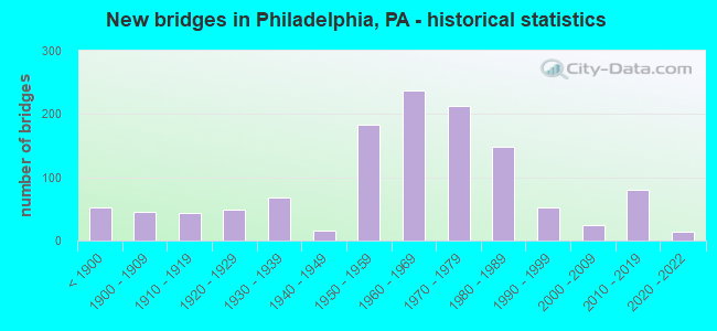
- New bridges - historical statistics
- 53Before 1900
- 451900-1909
- 431910-1919
- 481920-1929
- 681930-1939
- 151940-1949
- 1831950-1959
- 2381960-1969
- 2131970-1979
- 1491980-1989
- 531990-1999
- 252000-2009
- 802010-2019
- 142020-2022
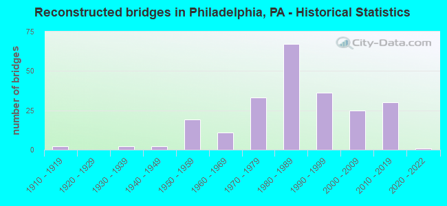
- Reconstructed bridges - Historical Statistics
- 21910-1919
- 01920-1929
- 21930-1939
- 21940-1949
- 191950-1959
- 111960-1969
- 331970-1979
- 671980-1989
- 361990-1999
- 252000-2009
- 302010-2019
- 12020-2022
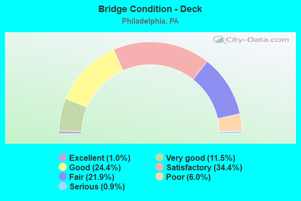
- Bridge Condition - Deck
- 1.0%Excellent
- 11.5%Very good
- 24.4%Good
- 34.4%Satisfactory
- 21.9%Fair
- 6.0%Poor
- 0.9%Serious
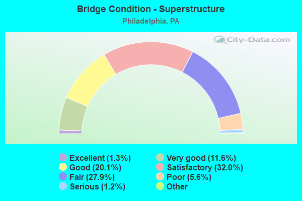
- Bridge Condition - Superstructure
- 1.5%Excellent
- 11.3%Very good
- 18.7%Good
- 32.9%Satisfactory
- 26.6%Fair
- 7.5%Poor
- 1.2%Serious
- 0.3%Imminent failure
- 0.2%Failed
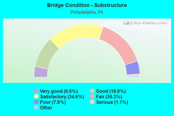
- Bridge Condition - Substructure
- 6.5%Excellent
- 18.9%Very good
- 34.6%Good
- 30.3%Satisfactory
- 7.9%Fair
- 1.1%Poor
- 0.8%Serious
- 0.2%Critical
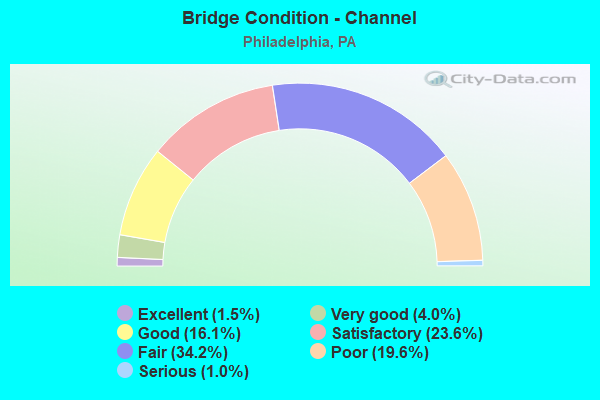
- Bridge Condition - Channel
- 1.5%Excellent
- 4.0%Very good
- 16.1%Good
- 23.6%Satisfactory
- 34.2%Fair
- 19.6%Poor
- 1.0%Serious
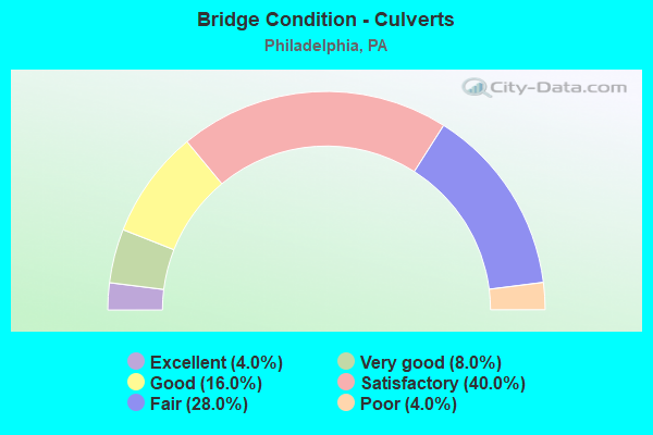
- Bridge Condition - Culverts
- 3.3%Excellent
- 6.7%Very good
- 20.0%Good
- 43.3%Satisfactory
- 23.3%Fair
- 3.3%Poor
Find on map >> Show street view
Structure Number: 39168, Location: S of Paschall Ave 36G04 (Lat: 39.926619, Lng: -75.228656), Route carried "on" structure: City street , Year Built: 1910, Status: Open, Structure Length: 3.23m (10.60ft), Average Daily Traffic: 4,000 (year 1980), Average Future Daily Traffic: 4,000 (year 1980), Features Intersected: AMTRAK (NE Corridor), Facility Carried by Structure: 62nd Street
Minimum Vertical Clearance: 9.14m (29.99ft), Kilometerpoint: 0.000, Lanes on structure: 2, Owner: City or Municipal Highway Agency, Approaching Roadway Width: 12.2m (40.0ft), Material/Design: Steel, Design/Construction: Truss - Deck, Number Of Spans In Main Unit: 3, Length of Maximum Span: 18.6m (61.0ft), Curb or Sidewalk Widths: Left: 4.0m (13.1ft), Right: 4.0m (13.1ft), Curb-To-Curb Width: 12.2m (40.0ft), Out-to-Out Width: 21.4m (70.2ft)
Condition: Deck: Fair, Superstructure: Satisfactory, Substructure: Fair, Operating Rating: 65.3 metric tons, Method Used To Determine Operating Rating: Allowable Stress (AS), Inventory Rating: 34.5 metric tons, Method Used To Determine Inventory Rating: Allowable Stress (AS), Structural Evaluation: Somewhat better than minimum adequacy, Deck Geometry: Equal to present minimum criteria, Underclear: High priority of corrective action, Approach Roadway Alignment: Equal to present minimum criteria, Length Of Structure Improvement: 3.20m (10.50ft), Designated Inspection Frequency: Every 24 months, Inspection Date: January 2020, Bridge Improvement Cost: $44,000, Roadway Improvement Cost: $129,000, Total Project Cost: $591,000, Deck Structure Type: Concrete Cast-file-Place, Wearing Surface/Protective System: Wearing Surface: Bituminous
Find on map >> Show street view
Structure Number: 39169, Location: S of Paschall Ave 36F04 (Lat: 39.925800, Lng: -75.229797), Route carried "on" structure: City street , Year Built: 1997, Status: Open, Structure Length: 2.19m (7.19ft), Average Daily Traffic: 4,300 (year 1994), Truck Traffic: 6%, Average Future Daily Traffic: 4,000 (year 1976), Design Load: HS 25 or greater, Features Intersected: AMTRAK (NE Corridor), Facility Carried by Structure: 63rd Street
Minimum Vertical Clearance: 9.14m (29.99ft), Kilometerpoint: 0.000, Lanes on structure: 2, Owner: City or Municipal Highway Agency, Approaching Roadway Width: 12.2m (40.0ft), Material/Design: Steel, Design/Construction: Stringer/Multi-beam, Number Of Spans In Main Unit: 1, Length of Maximum Span: 21.3m (69.9ft), Curb or Sidewalk Widths: Left: 2.4m (7.9ft), Right: 2.4m (7.9ft), Curb-To-Curb Width: 12.2m (40.0ft), Out-to-Out Width: 17.7m (58.1ft)
Condition: Deck: Very good, Superstructure: Very good, Substructure: Very good, Operating Rating: 76.2 metric tons, Method Used To Determine Operating Rating: Load Factor (LF), Inventory Rating: 45.4 metric tons, Method Used To Determine Inventory Rating: Load Factor (LF), Structural Evaluation: Equal to present desirable criteria, Deck Geometry: Equal to present minimum criteria, Underclear: High priority of corrective action, Approach Roadway Alignment: Equal to present minimum criteria, Length Of Structure Improvement: 4.20m (13.78ft), Designated Inspection Frequency: Every 24 months, Inspection Date: January 2020, Deck Structure Type: Corrugated Steel, Wearing Surface/Protective System: Wearing Surface: Monolithic Concrete, Deck Protection: Epoxy Coated Reinforcing
Find on map >> Show street view
Structure Number: 3917, Location: at 7th Street 28J03 (Lat: 40.001325, Lng: -75.141856), Route carried "on" structure: City street , Year Built: 1915, Status: Posted for load, Structure Length: 1.86m (6.10ft), Average Daily Traffic: 3,600 (year 1980), Average Future Daily Traffic: 5,040 (year 2000), Features Intersected: CONRAIL, Facility Carried by Structure: Glenwood Avenue
Minimum Vertical Clearance: 30+ m (98+ ft), Kilometerpoint: 0.000, Lanes on structure: 2, Owner: City or Municipal Highway Agency, Approaching Roadway Width: 10.4m (34.1ft), Skew: 1 degrees, Material/Design: Steel, Design/Construction: Girder and Floorbeam System, Number Of Spans In Main Unit: 1, Length of Maximum Span: 18.3m (60.0ft), Curb or Sidewalk Widths: Left: 3.0m (9.8ft), Right: 3.0m (9.8ft), Curb-To-Curb Width: 10.4m (34.1ft), Out-to-Out Width: 17.3m (56.8ft)
Condition: Deck: Fair, Superstructure: Fair, Substructure: Satisfactory, Operating Rating: 58.1 metric tons, Method Used To Determine Operating Rating: Allowable Stress (AS), Inventory Rating: 36.3 metric tons, Method Used To Determine Inventory Rating: Allowable Stress (AS), Structural Evaluation: Somewhat better than minimum adequacy, Deck Geometry: Somewhat better than minimum adequacy, Underclear: High priority of corrective action, Approach Roadway Alignment: Equal to present minimum criteria, Length Of Structure Improvement: 2.50m (8.20ft), Designated Inspection Frequency: Every 24 months, Other Special Inspection Frequency: Every 12 months, Inspection Date: July 2021, Other Special Inspection Date: July 2021, Bridge Improvement Cost: $18,000, Roadway Improvement Cost: $52,000, Total Project Cost: $238,000, Wearing Surface/Protective System: Wearing Surface: Bituminous
Find on map >> Show street view
Structure Number: 39171, Location: at Nineteenth St 3590-D1 (Lat: 39.993997, Lng: -75.163700), Route carried "on" structure: City street , Year Built: 1919, Year Reconstructed: 1969, Status: Closed, Structure Length: 3.41m (11.19ft), Average Future Daily Traffic: 4,300 (year 2015), Features Intersected: AMTRAK, CONRAIL, Facility Carried by Structure: Margie Street
Minimum Vertical Clearance: 30+ m (98+ ft), Kilometerpoint: 0.000, Lanes on structure: 2, Owner: City or Municipal Highway Agency, Approaching Roadway Width: 11.0m (36.1ft), Material/Design: Steel, Design/Construction: Truss - Thru, Number Of Spans In Main Unit: 1, Length of Maximum Span: 31.1m (102.0ft), Curb or Sidewalk Widths: Left: 2.3m (7.5ft), Right: 2.3m (7.5ft), Curb-To-Curb Width: 11.0m (36.1ft), Out-to-Out Width: 11.0m (36.1ft)
Condition: Deck: Poor, Superstructure: Imminent failure, Substructure: Serious, Deck Geometry: Superior to present desirable criteria, Approach Roadway Alignment: High priority of corrective action, Bridge Posting: Required (Relationship of Operating Rating to Maximum Legal Load: > 39.9% below), Length Of Structure Improvement: 3.40m (11.15ft), Designated Inspection Frequency: Every 24 months, Inspection Date: November 2020, Bridge Improvement Cost: $22,000, Roadway Improvement Cost: $65,000, Total Project Cost: $297,000, Deck Structure Type: Closed Grating, Wearing Surface/Protective System: Wearing Surface: Bituminous
Find on map >> Show street view
Structure Number: 39172, Location: S of Bloomfield Rd 08K13 (Lat: 40.090200, Lng: -75.069400), Route carried "on" structure: City street , Year Built: 1977, Status: Open, Structure Length: 2.56m (8.40ft), Average Daily Traffic: 10,700 (year 1983), Average Future Daily Traffic: 14,980 (year 2003), Design Load: HS 20, Features Intersected: Pennypack Creek, Facility Carried by Structure: Pine Road
Minimum Vertical Clearance: 30+ m (98+ ft), Kilometerpoint: 0.000, Lanes on structure: 2, Owner: City or Municipal Highway Agency, Approaching Roadway Width: 13.4m (44.0ft), Material/Design: Steel, Design/Construction: Stringer/Multi-beam, Number Of Spans In Main Unit: 1, Length of Maximum Span: 24.4m (80.1ft), Curb or Sidewalk Widths: Left: 1.8m (5.9ft), Right: 1.8m (5.9ft), Curb-To-Curb Width: 13.4m (44.0ft), Out-to-Out Width: 18.1m (59.4ft)
Condition: Deck: Fair, Superstructure: Fair, Substructure: Poor, Channel: Satisfactory, Operating Rating: 50.8 metric tons, Method Used To Determine Operating Rating: Allowable Stress (AS), Inventory Rating: 15.4 metric tons, Method Used To Determine Inventory Rating: Allowable Stress (AS), Structural Evaluation: High priority of corrective action, Deck Geometry: Equal to present minimum criteria, Waterway Adequacy: Better than present minimum criteria, Approach Roadway Alignment: Equal to present desirable criteria, Length Of Structure Improvement: 3.30m (10.83ft), Designated Inspection Frequency: Every 24 months, Other Special Inspection Frequency: Every 12 months, Inspection Date: June 2020, Other Special Inspection Date: June 2021, Bridge Improvement Cost: $69,000, Roadway Improvement Cost: $203,000, Total Project Cost: $930,000, Deck Structure Type: Concrete Cast-file-Place, Wearing Surface/Protective System: Wearing Surface: Monolithic Concrete, Deck Protection: Galvanized Reinforcing
Find on map >> Show street view
Structure Number: 39173, Location: BTWN 26TH & 27TH 28D09 (Lat: 39.968986, Lng: -75.181592), Route carried "on" structure: City street , Year Built: 1931, Status: Open, Structure Length: 4.39m (14.40ft), Average Daily Traffic: 75,000 (year 1977), Average Future Daily Traffic: 105,000 (year 1997), Design Load: HS 25 or greater, Features Intersected: Conrail & B&O Railroad, Facility Carried by Structure: Pennsylvania Ave.
Minimum Vertical Clearance: 30+ m (98+ ft), Kilometerpoint: 0.000, Lanes on structure: 2, Owner: City or Municipal Highway Agency, Approaching Roadway Width: 8.5m (27.9ft), Skew: 38 degrees, Material/Design: Concrete continuous, Design/Construction: Stringer/Multi-beam, Number Of Spans In Main Unit: 3, Length of Maximum Span: 20.1m (65.9ft), Curb or Sidewalk Widths: Left: 6.4m (21.0ft), Right: 7.7m (25.3ft), Curb-To-Curb Width: 20.2m (66.3ft), Out-to-Out Width: 42.8m (140.4ft)
Condition: Deck: Fair, Superstructure: Fair, Substructure: Fair, Operating Rating: 70.8 metric tons, Method Used To Determine Operating Rating: Allowable Stress (AS), Inventory Rating: 36.3 metric tons, Method Used To Determine Inventory Rating: Allowable Stress (AS), Structural Evaluation: Somewhat better than minimum adequacy, Deck Geometry: Superior to present desirable criteria, Underclear: High priority of corrective action, Approach Roadway Alignment: Equal to present desirable criteria, Length Of Structure Improvement: 5.30m (17.39ft), Designated Inspection Frequency: Every 24 months, Inspection Date: December 2020, Bridge Improvement Cost: $246,000, Roadway Improvement Cost: $725,000, Total Project Cost: $3,322,000, Deck Structure Type: Other, Wearing Surface/Protective System: Wearing Surface: Bituminous, Membrane: Built-up
Find on map >> Show street view
Structure Number: 39174, Location: S.PASCHALL AVE 3669-B3 (Lat: 39.918997, Lng: -75.239500), Route carried "on" structure: City street , Year Built: 1949, Status: Posted for load, Structure Length: 3.08m (10.10ft), Average Daily Traffic: 10,200 (year 2012), Truck Traffic: 1%, Average Future Daily Traffic: 13,100 (year 2032), Design Load: HS 20, Features Intersected: AMTRAK (NE Corridor), Facility Carried by Structure: 70th Street
Minimum Vertical Clearance: 30+ m (98+ ft), Kilometerpoint: 0.000, Lanes on structure: 2, Owner: City or Municipal Highway Agency, Approaching Roadway Width: 12.2m (40.0ft), Material/Design: Steel, Design/Construction: Girder and Floorbeam System, Number Of Spans In Main Unit: 1, Length of Maximum Span: 29.9m (98.1ft), Curb or Sidewalk Widths: Left: 2.4m (7.9ft), Right: 2.4m (7.9ft), Curb-To-Curb Width: 12.2m (40.0ft), Out-to-Out Width: 19.4m (63.6ft)
Condition: Deck: Poor, Superstructure: Fair, Substructure: Satisfactory, Operating Rating: 25.4 metric tons, Method Used To Determine Operating Rating: Load Factor (LF), Inventory Rating: 15.4 metric tons, Method Used To Determine Inventory Rating: Load Factor (LF), Structural Evaluation: High priority of corrective action, Deck Geometry: Somewhat better than minimum adequacy, Underclear: High priority of corrective action, Approach Roadway Alignment: Somewhat better than minimum adequacy, Bridge Posting: Required (Relationship of Operating Rating to Maximum Legal Load: 20.0 - 29.9% below), Length Of Structure Improvement: 3.10m (10.17ft), Designated Inspection Frequency: Every 24 months, Critical Feature Inspection Frequency: Every 12 months, Other Special Inspection Frequency: Every 12 months, Inspection Date: Febuary 2021, Critical Feature Inspection Date: Febuary 2021, Other Special Inspection Date: Febuary 2021, Deck Structure Type: Concrete Cast-file-Place, Wearing Surface/Protective System: Wearing Surface: Bituminous
Find on map >> Show street view
Structure Number: 39175, Location: W of Seventh St 28J03 (Lat: 40.002647, Lng: -75.142908), Route carried "on" structure: City street , Year Built: 1907, Year Reconstructed: 2017, Status: Open, Structure Length: 2.04m (6.69ft), Average Daily Traffic: 6,300 (year 1979), Average Future Daily Traffic: 6,300 (year 1979), Design Load: HL 93, Features Intersected: CONRAIL, Facility Carried by Structure: Sedgley Avenue
Minimum Vertical Clearance: 30+ m (98+ ft), Kilometerpoint: 0.000, Lanes on structure: 2, Owner: City or Municipal Highway Agency, Approaching Roadway Width: 10.4m (34.1ft), Material/Design: Steel, Design/Construction: Girder and Floorbeam System, Number Of Spans In Main Unit: 1, Length of Maximum Span: 19.8m (65.0ft), Curb or Sidewalk Widths: Left: 3.0m (9.8ft), Right: 2.9m (9.5ft), Curb-To-Curb Width: 10.5m (34.4ft), Out-to-Out Width: 18.3m (60.0ft)
Condition: Deck: Very good, Superstructure: Very good, Substructure: Very good, Operating Rating: 59.0 metric tons, Method Used To Determine Operating Rating: Assigned ratings based on Load and Resistance Factor Design (LRFD) reported by rating factor (RF) using HL93 loadings, Inventory Rating: 45.4 metric tons, Method Used To Determine Inventory Rating: Assigned ratings based on Load and Resistance Factor Design (LRFD) reported by rating factor (RF) using HL93 loadings, Structural Evaluation: Equal to present desirable criteria, Deck Geometry: Meets minimum limits, Underclear: High priority of replacement, Approach Roadway Alignment: Somewhat better than minimum adequacy, Length Of Structure Improvement: 2.00m (6.56ft), Designated Inspection Frequency: Every 24 months, Inspection Date: June 2021, Bridge Improvement Cost: $55,000, Roadway Improvement Cost: $163,000, Total Project Cost: $745,000, Deck Structure Type: Closed Grating
Find on map >> Show street view
Structure Number: 39176, Location: N of St. Martins Ln 16K04 (Lat: 40.066200, Lng: -75.205297), Route carried "on" structure: City street , Year Built: 1883, Year Reconstructed: 2015, Status: Open, Structure Length: 2.26m (7.41ft), Average Daily Traffic: 6,880 (year 2012), Average Future Daily Traffic: 8,800 (year 2032), Design Load: HS 20, Features Intersected: SEPTA, Facility Carried by Structure: Willow Grove Ave.
Minimum Vertical Clearance: 30+ m (98+ ft), Kilometerpoint: 0.000, Lanes on structure: 2, Owner: City or Municipal Highway Agency, Approaching Roadway Width: 8.5m (27.9ft), Material/Design: Steel continuous, Design/Construction: Stringer/Multi-beam, Number Of Spans In Main Unit: 3, Length of Maximum Span: 8.8m (28.9ft), Curb or Sidewalk Widths: Left: 1.5m (4.9ft), Right: 1.5m (4.9ft), Curb-To-Curb Width: 8.5m (27.9ft), Out-to-Out Width: 12.5m (41.0ft)
Condition: Deck: Very good, Superstructure: Very good, Substructure: Very good, Operating Rating: 60.8 metric tons, Method Used To Determine Operating Rating: Load and Resistance Factor (LRFR), Inventory Rating: 47.2 metric tons, Method Used To Determine Inventory Rating: Load and Resistance Factor (LRFR), Structural Evaluation: Equal to present desirable criteria, Underclear: High priority of replacement, Approach Roadway Alignment: Better than present minimum criteria, Length Of Structure Improvement: 2.30m (7.55ft), Designated Inspection Frequency: Every 24 months, Critical Feature Inspection Frequency: Every 24 months, Inspection Date: March 2020, Critical Feature Inspection Date: March 2020, Bridge Improvement Cost: $22,000, Roadway Improvement Cost: $65,000, Total Project Cost: $297,000, Deck Structure Type: Concrete Cast-file-Place, Wearing Surface/Protective System: Wearing Surface: Monolithic Concrete, Deck Protection: Epoxy Coated Reinforcing
Find on map >> Show street view
Structure Number: 39177, Location: WISSAHICKON CREEK 16H06 (Lat: 40.055400, Lng: -75.217750), Route carried "on" structure: Other road , Year Built: 1915, Status: Posted for load, Structure Length: 2.04m (6.69ft), Average Daily Traffic: 100 (year 1982), Average Future Daily Traffic: 100 (year 1982), Features Intersected: Wissahickon Creek, Facility Carried by Structure: Valley Green Road
Minimum Vertical Clearance: 30+ m (98+ ft), Kilometerpoint: 0.000, Lanes on structure: 2, Owner: City or Municipal Highway Agency, Approaching Roadway Width: 6.7m (22.0ft), Material/Design: Masonry, Design/Construction: Arch - Deck, Number Of Spans In Main Unit: 1, Length of Maximum Span: 20.4m (66.9ft), Curb-To-Curb Width: 6.9m (22.6ft), Out-to-Out Width: 8.2m (26.9ft)
Condition: Superstructure: Fair, Substructure: Critical, Channel: Serious, Operating Rating: 18.1 metric tons, Method Used To Determine Operating Rating: Field evaluation and documented engineering judgment, Inventory Rating: 9.1 metric tons, Method Used To Determine Inventory Rating: Field evaluation and documented engineering judgment, Structural Evaluation: High priority of replacement, Deck Geometry: Somewhat better than minimum adequacy, Waterway Adequacy: Equal to present desirable criteria, Approach Roadway Alignment: Equal to present desirable criteria, Bridge Posting: Required (Relationship of Operating Rating to Maximum Legal Load: > 39.9% below), Length Of Structure Improvement: 1.90m (6.23ft), Designated Inspection Frequency: Every 24 months, Underwater Inspection Frequency: Every 6 months, Other Special Inspection Frequency: Every 6 months, Inspection Date: April 2021, Underwater Inspection Date: April 2021, Other Special Inspection Date: September 2021, Bridge Improvement Cost: $16,000, Roadway Improvement Cost: $47,000, Total Project Cost: $216,000, Wearing Surface/Protective System: Wearing Surface: Bituminous
Find on map >> Show street view
Structure Number: 39178, Location: S of Paschall Avenu 36E05 (Lat: 39.917894, Lng: -75.241067), Route carried "on" structure: City street , Year Built: 1901, Year Reconstructed: 1915, Status: Posted for load, Structure Length: 3.72m (12.20ft), Average Daily Traffic: 40,000 (year 1980), Average Future Daily Traffic: 4,000 (year 1980), Features Intersected: AMTRAK (NE Corridor), Facility Carried by Structure: 71st Street
Minimum Vertical Clearance: 7.62m (25.00ft), Kilometerpoint: 0.000, Lanes on structure: 2, Owner: City or Municipal Highway Agency, Approaching Roadway Width: 12.2m (40.0ft), Material/Design: Steel, Design/Construction: Stringer/Multi-beam, Number Of Spans In Main Unit: 1, Number Of Approach Spans: 2, Length of Maximum Span: 17.1m (56.1ft), Curb or Sidewalk Widths: Left: 3.2m (10.5ft), Right: 3.2m (10.5ft), Curb-To-Curb Width: 12.2m (40.0ft), Out-to-Out Width: 19.6m (64.3ft)
Condition: Deck: Satisfactory, Superstructure: Satisfactory, Substructure: Satisfactory, Operating Rating: 73.5 metric tons, Method Used To Determine Operating Rating: Allowable Stress (AS), Inventory Rating: 4.5 metric tons, Method Used To Determine Inventory Rating: Allowable Stress (AS), Structural Evaluation: High priority of corrective action, Deck Geometry: Somewhat better than minimum adequacy, Underclear: High priority of corrective action, Approach Roadway Alignment: Somewhat better than minimum adequacy, Length Of Structure Improvement: 4.00m (13.12ft), Designated Inspection Frequency: Every 24 months, Other Special Inspection Frequency: Every 12 months, Inspection Date: Febuary 2020, Other Special Inspection Date: Febuary 2021, Bridge Improvement Cost: $12,000, Roadway Improvement Cost: $56,000, Total Project Cost: $161,000, Wearing Surface/Protective System: Wearing Surface: Bituminous
Find on map >> Show street view
Structure Number: 39179, Location: S of Paschell Ave 36E05 (Lat: 39.916906, Lng: -75.242444), Route carried "on" structure: City street , Year Built: 1913, Status: Posted for load, Structure Length: 3.17m (10.40ft), Average Daily Traffic: 2,000 (year 1980), Average Future Daily Traffic: 2,000 (year 1980), Design Load: HS 25 or greater, Features Intersected: AMTRAK (NE Corridor), Facility Carried by Structure: 72nd Street
Minimum Vertical Clearance: 7.62m (25.00ft), Kilometerpoint: 0.000, Lanes on structure: 2, Owner: City or Municipal Highway Agency, Approaching Roadway Width: 12.2m (40.0ft), Material/Design: Steel, Design/Construction: Stringer/Multi-beam, Number Of Spans In Main Unit: 3, Length of Maximum Span: 18.3m (60.0ft), Curb or Sidewalk Widths: Left: 3.9m (12.8ft), Right: 3.9m (12.8ft), Curb-To-Curb Width: 12.2m (40.0ft), Out-to-Out Width: 21.0m (68.9ft)
Condition: Deck: Fair, Superstructure: Fair, Substructure: Poor, Operating Rating: 22.7 metric tons, Method Used To Determine Operating Rating: Allowable Stress (AS), Inventory Rating: 10.9 metric tons, Method Used To Determine Inventory Rating: Allowable Stress (AS), Structural Evaluation: High priority of corrective action, Deck Geometry: Better than present minimum criteria, Underclear: High priority of corrective action, Approach Roadway Alignment: Meets minimum limits, Bridge Posting: Required (Relationship of Operating Rating to Maximum Legal Load: 30.0 - 39.9% below), Length Of Structure Improvement: 3.20m (10.50ft), Designated Inspection Frequency: Every 24 months, Other Special Inspection Frequency: Every 12 months, Inspection Date: Febuary 2020, Other Special Inspection Date: Febuary 2021, Bridge Improvement Cost: $72,000, Roadway Improvement Cost: $212,000, Total Project Cost: $972,000, Wearing Surface/Protective System: Wearing Surface: Bituminous
Find on map >> Show street view
Structure Number: 3918, Location: PASSYUNK OVERPASS 37B05 (Lat: 39.921700, Lng: -75.190833), Route carried "on" structure: Interstate 76, Year Built: 1957, Year Reconstructed: 1999, Status: Open, Structure Length: 11.00m (36.09ft), Average Daily Traffic: 21,524 (year 2020), Truck Traffic: 6%, Average Future Daily Traffic: 26,263 (year 2040), Design Load: HS 20, Features Intersected: 26TH ST;PASSYUNK AVE
Minimum Vertical Clearance: 30+ m (98+ ft), Kilometerpoint: 0.000, Lanes on structure: 2, Lanes under structure: 11, Base Highway Network: Yes, Owner: Local Toll Authority, Approaching Roadway Width: 10.4m (34.1ft), Skew: 9 degrees, Material/Design: Steel continuous, Design/Construction: Stringer/Multi-beam, Number Of Spans In Main Unit: 5, Length of Maximum Span: 27.4m (89.9ft), Curb-To-Curb Width: 10.0m (32.8ft), Out-to-Out Width: 10.8m (35.4ft)
Condition: Deck: Good, Superstructure: Good, Substructure: Good, Operating Rating: 99.8 metric tons, Method Used To Determine Operating Rating: Load Factor (LF), Inventory Rating: 59.9 metric tons, Method Used To Determine Inventory Rating: Load Factor (LF), Structural Evaluation: Better than present minimum criteria, Deck Geometry: Meets minimum limits, Underclear: High priority of corrective action, Approach Roadway Alignment: Equal to present desirable criteria, Designated Inspection Frequency: Every 24 months, Inspection Date: May 2020, Deck Structure Type: Concrete Cast-file-Place, Wearing Surface/Protective System: Wearing Surface: Monolithic Concrete, Deck Protection: Epoxy Coated Reinforcing
Find on map >> Show street view
Structure Number: 39181, Location: PASSYUNK AVE OVPAS 37B05 (Lat: 39.921389, Lng: -75.189444), Route carried "on" structure: Interstate 76, Year Built: 1957, Year Reconstructed: 2000, Status: Open, Structure Length: 18.87m (61.91ft), Average Daily Traffic: 23,768 (year 2020), Truck Traffic: 6%, Average Future Daily Traffic: 29,001 (year 2040), Design Load: HS 20, Features Intersected: PASSYUNK AVE;VARE AVE
Minimum Vertical Clearance: 30+ m (98+ ft), Kilometerpoint: 0.000, Lanes on structure: 2, Lanes under structure: 10, Base Highway Network: Yes, Owner: Local Toll Authority, Approaching Roadway Width: 12.2m (40.0ft), Skew: 9 degrees, Material/Design: Steel, Design/Construction: Stringer/Multi-beam, Number Of Spans In Main Unit: 11, Length of Maximum Span: 23.5m (77.1ft), Curb-To-Curb Width: 15.8m (51.8ft), Out-to-Out Width: 16.6m (54.5ft)
Condition: Deck: Good, Superstructure: Good, Substructure: Good, Inventory Rating: 61.7 metric tons, Method Used To Determine Inventory Rating: Load Factor (LF), Structural Evaluation: Better than present minimum criteria, Deck Geometry: Superior to present desirable criteria, Underclear: Equal to present minimum criteria, Approach Roadway Alignment: Equal to present desirable criteria, Designated Inspection Frequency: Every 24 months, Inspection Date: May 2020, Deck Structure Type: Concrete Cast-file-Place, Wearing Surface/Protective System: Wearing Surface: Monolithic Concrete, Deck Protection: Epoxy Coated Reinforcing
Find on map >> Show street view
Structure Number: 39182, Location: MOYAMENSING OVPASS 37D06 (Lat: 39.913333, Lng: -75.182500), Route carried "on" structure: Interstate 76, Year Built: 1957, Year Reconstructed: 1999, Status: Open, Structure Length: 27.86m (91.40ft), Average Daily Traffic: 25,707 (year 2020), Truck Traffic: 6%, Average Future Daily Traffic: 31,367 (year 2040), Design Load: HS 20, Features Intersected: MOYAMENSING AVE;RAMP N
Minimum Vertical Clearance: 30+ m (98+ ft), Kilometerpoint: 0.000, Lanes on structure: 2, Lanes under structure: 10, Base Highway Network: Yes, Owner: Local Toll Authority, Approaching Roadway Width: 11.0m (36.1ft), Skew: 5 degrees, Material/Design: Steel continuous, Design/Construction: Stringer/Multi-beam, Number Of Spans In Main Unit: 11, Length of Maximum Span: 35.1m (115.2ft), Curb-To-Curb Width: 9.8m (32.2ft), Out-to-Out Width: 10.6m (34.8ft)
Condition: Deck: Satisfactory, Superstructure: Good, Substructure: Satisfactory, Inventory Rating: 65.3 metric tons, Method Used To Determine Inventory Rating: Load Factor (LF), Structural Evaluation: Equal to present minimum criteria, Deck Geometry: Meets minimum limits, Underclear: Somewhat better than minimum adequacy, Approach Roadway Alignment: Equal to present desirable criteria, Designated Inspection Frequency: Every 24 months, Inspection Date: May 2020, Deck Structure Type: Concrete Cast-file-Place, Wearing Surface/Protective System: Wearing Surface: Monolithic Concrete, Deck Protection: Epoxy Coated Reinforcing
Find on map >> Show street view
Structure Number: 39183, Location: RAMP M 37D06 (Lat: 39.912500, Lng: -75.181700), Route carried "on" structure: Ramp Interstate , Year Built: 1957, Year Reconstructed: 1999, Status: Open, Structure Length: 21.12m (69.29ft), Average Daily Traffic: 5,101 (year 2020), Truck Traffic: 6%, Average Future Daily Traffic: 6,224 (year 2040), Design Load: HS 20, Features Intersected: PACKER AVE;TWENTIETH ST, Facility Carried by Structure: RAMP M
Minimum Vertical Clearance: 30+ m (98+ ft), Kilometerpoint: 0.000, Lanes on structure: 1, Lanes under structure: 4, Base Highway Network: Yes, Owner: Local Toll Authority, Approaching Roadway Width: 10.4m (34.1ft), Skew: 9 degrees, Material/Design: Steel continuous, Design/Construction: Stringer/Multi-beam, Number Of Spans In Main Unit: 9, Length of Maximum Span: 32.9m (107.9ft), Curb-To-Curb Width: 9.1m (29.9ft), Out-to-Out Width: 10.0m (32.8ft)
Condition: Deck: Good, Superstructure: Good, Substructure: Good, Operating Rating: 93.4 metric tons, Method Used To Determine Operating Rating: Load Factor (LF), Inventory Rating: 55.3 metric tons, Method Used To Determine Inventory Rating: Load Factor (LF), Structural Evaluation: Better than present minimum criteria, Deck Geometry: Superior to present desirable criteria, Underclear: Equal to present minimum criteria, Approach Roadway Alignment: Equal to present desirable criteria, Designated Inspection Frequency: Every 24 months, Inspection Date: July 2020, Deck Structure Type: Concrete Cast-file-Place, Wearing Surface/Protective System: Wearing Surface: Monolithic Concrete, Deck Protection: Epoxy Coated Reinforcing
Find on map >> Show street view
Structure Number: 39184, Location: MOYAMENSING OVPASS 37D06 (Lat: 39.913297, Lng: -75.181389), Route carried "on" structure: Interstate 76, Year Built: 1957, Year Reconstructed: 1986, Status: Open, Structure Length: 14.45m (47.41ft), Average Daily Traffic: 23,768 (year 2020), Truck Traffic: 6%, Average Future Daily Traffic: 29,001 (year 2040), Design Load: HS 20, Features Intersected: MOYAMENSING ST;TWENTIETH
Minimum Vertical Clearance: 30+ m (98+ ft), Kilometerpoint: 0.000, Lanes on structure: 3, Lanes under structure: 14, Base Highway Network: Yes, Owner: Local Toll Authority, Approaching Roadway Width: 14.0m (45.9ft), Skew: 3 degrees, Material/Design: Steel continuous, Design/Construction: Stringer/Multi-beam, Number Of Spans In Main Unit: 8, Length of Maximum Span: 29.3m (96.1ft), Curb-To-Curb Width: 13.4m (44.0ft), Out-to-Out Width: 14.2m (46.6ft)
Condition: Deck: Satisfactory, Superstructure: Good, Substructure: Satisfactory, Inventory Rating: 60.8 metric tons, Method Used To Determine Inventory Rating: Load Factor (LF), Structural Evaluation: Equal to present minimum criteria, Deck Geometry: Meets minimum limits, Underclear: Meets minimum limits, Approach Roadway Alignment: Equal to present desirable criteria, Length Of Structure Improvement: 15.40m (50.52ft), Designated Inspection Frequency: Every 24 months, Inspection Date: May 2020, Bridge Improvement Cost: $1,288,000, Roadway Improvement Cost: $143,000, Total Project Cost: $1,431,000 ( Estimate for 2020), Deck Structure Type: Concrete Cast-file-Place, Wearing Surface/Protective System: Wearing Surface: Monolithic Concrete, Deck Protection: Epoxy Coated Reinforcing
Find on map >> Show street view
Structure Number: 39185, Location: RAMP K-L 37D06 (Lat: 39.911944, Lng: -75.173889), Route carried "on" structure: Interstate 76, Year Built: 1957, Year Reconstructed: 1995, Status: Open, Structure Length: 2.41m (7.91ft), Average Daily Traffic: 6,937 (year 2020), Truck Traffic: 6%, Average Future Daily Traffic: 8,464 (year 2040), Design Load: HS 20, Features Intersected: PACKER AVENUE
Minimum Vertical Clearance: 30+ m (98+ ft), Kilometerpoint: 0.000, Lanes on structure: 2, Lanes under structure: 4, Base Highway Network: Yes, Owner: Local Toll Authority, Approaching Roadway Width: 11.6m (38.1ft), Skew: 30 degrees, Material/Design: Steel, Design/Construction: Stringer/Multi-beam, Number Of Spans In Main Unit: 1, Length of Maximum Span: 24.1m (79.1ft), Curb-To-Curb Width: 11.6m (38.1ft), Out-to-Out Width: 13.0m (42.7ft)
Condition: Deck: Good, Superstructure: Good, Substructure: Good, Inventory Rating: 65.3 metric tons, Method Used To Determine Inventory Rating: Load Factor (LF), Structural Evaluation: Better than present minimum criteria, Deck Geometry: Somewhat better than minimum adequacy, Underclear: Equal to present minimum criteria, Approach Roadway Alignment: Meets minimum limits, Designated Inspection Frequency: Every 24 months, Inspection Date: July 2020, Deck Structure Type: Concrete Cast-file-Place, Wearing Surface/Protective System: Wearing Surface: Latex Concrete, Deck Protection: Epoxy Coated Reinforcing
Find on map >> Show street view
Structure Number: 39186, Location: BROAD ST OVERPASS 37E06 (Lat: 39.912500, Lng: -75.172500), Route carried "on" structure: Interstate 76, Year Built: 1957, Year Reconstructed: 1995, Status: Open, Structure Length: 9.20m (30.18ft), Average Daily Traffic: 80,588 (year 2020), Truck Traffic: 6%, Average Future Daily Traffic: 98,333 (year 2040), Design Load: HS 20, Features Intersected: BROAD STREET
Minimum Vertical Clearance: 30+ m (98+ ft), Kilometerpoint: 0.000, Lanes on structure: 6, Lanes under structure: 7, Base Highway Network: Yes, Owner: Local Toll Authority, Approaching Roadway Width: 29.9m (98.1ft), Skew: 30 degrees, Material/Design: Steel continuous, Design/Construction: Stringer/Multi-beam, Number Of Spans In Main Unit: 3, Length of Maximum Span: 35.7m (117.1ft), Curb-To-Curb Width: 29.5m (96.8ft), Out-to-Out Width: 31.2m (102.4ft)
Condition: Deck: Satisfactory, Superstructure: Satisfactory, Substructure: Good, Operating Rating: 91.6 metric tons, Method Used To Determine Operating Rating: Load Factor (LF), Inventory Rating: 54.4 metric tons, Method Used To Determine Inventory Rating: Load Factor (LF), Structural Evaluation: Equal to present minimum criteria, Deck Geometry: Equal to present desirable criteria, Underclear: Meets minimum limits, Approach Roadway Alignment: Equal to present desirable criteria, Designated Inspection Frequency: Every 24 months, Inspection Date: July 2020, Deck Structure Type: Concrete Cast-file-Place, Wearing Surface/Protective System: Wearing Surface: Latex Concrete, Deck Protection: Epoxy Coated Reinforcing
Find on map >> Show street view
Structure Number: 39187, Location: TENTH ST.OVERPASS 37F06 (Lat: 39.911389, Lng: -75.165556), Route carried "on" structure: Interstate 76, Year Built: 1957, Year Reconstructed: 1995, Status: Open, Structure Length: 5.91m (19.39ft), Average Daily Traffic: 80,588 (year 2020), Truck Traffic: 6%, Average Future Daily Traffic: 98,333 (year 2040), Design Load: HS 20, Features Intersected: TENTH STREET
Minimum Vertical Clearance: 30+ m (98+ ft), Kilometerpoint: 0.000, Lanes on structure: 8, Lanes under structure: 5, Base Highway Network: Yes, Owner: Local Toll Authority, Approaching Roadway Width: 35.4m (116.1ft), Skew: 30 degrees, Material/Design: Steel continuous, Design/Construction: Stringer/Multi-beam, Number Of Spans In Main Unit: 3, Length of Maximum Span: 24.4m (80.1ft), Curb-To-Curb Width: 35.4m (116.1ft), Out-to-Out Width: 37.4m (122.7ft)
Condition: Deck: Good, Superstructure: Good, Substructure: Good, Operating Rating: 95.3 metric tons, Method Used To Determine Operating Rating: Load Factor (LF), Inventory Rating: 57.2 metric tons, Method Used To Determine Inventory Rating: Load Factor (LF), Structural Evaluation: Better than present minimum criteria, Deck Geometry: Equal to present minimum criteria, Underclear: Meets minimum limits, Approach Roadway Alignment: Equal to present desirable criteria, Designated Inspection Frequency: Every 24 months, Inspection Date: July 2020, Deck Structure Type: Concrete Cast-file-Place, Wearing Surface/Protective System: Wearing Surface: Latex Concrete, Deck Protection: Epoxy Coated Reinforcing
Find on map >> Show street view
Structure Number: 39188, Location: SEVENTH OVERPASS 37G07 (Lat: 39.910833, Lng: -75.160833), Route carried "on" structure: Interstate 76, Year Built: 1957, Year Reconstructed: 1995, Status: Open, Structure Length: 5.91m (19.39ft), Average Daily Traffic: 80,588 (year 2020), Truck Traffic: 6%, Average Future Daily Traffic: 98,333 (year 2040), Design Load: HS 20, Features Intersected: SEVENTH STREET
Minimum Vertical Clearance: 30+ m (98+ ft), Kilometerpoint: 0.000, Lanes on structure: 8, Lanes under structure: 6, Base Highway Network: Yes, Owner: Local Toll Authority, Approaching Roadway Width: 38.4m (126.0ft), Skew: 30 degrees, Material/Design: Steel continuous, Design/Construction: Stringer/Multi-beam, Number Of Spans In Main Unit: 3, Length of Maximum Span: 24.4m (80.1ft), Curb-To-Curb Width: 37.6m (123.4ft), Out-to-Out Width: 39.3m (128.9ft)
Condition: Deck: Good, Superstructure: Good, Substructure: Good, Operating Rating: 94.3 metric tons, Method Used To Determine Operating Rating: Load Factor (LF), Inventory Rating: 56.2 metric tons, Method Used To Determine Inventory Rating: Load Factor (LF), Structural Evaluation: Better than present minimum criteria, Deck Geometry: Superior to present desirable criteria, Underclear: Equal to present minimum criteria, Approach Roadway Alignment: Equal to present desirable criteria, Designated Inspection Frequency: Every 24 months, Inspection Date: July 2020, Deck Structure Type: Concrete Cast-file-Place, Wearing Surface/Protective System: Wearing Surface: Latex Concrete, Deck Protection: Epoxy Coated Reinforcing
Find on map >> Show street view
Structure Number: 39189, Location: RANDOLPH OVERPASS 37G06 (Lat: 39.910556, Lng: -75.158889), Route carried "on" structure: Interstate 76, Year Built: 1957, Year Reconstructed: 1995, Status: Open, Structure Length: 4.57m (14.99ft), Average Daily Traffic: 80,588 (year 2020), Truck Traffic: 6%, Average Future Daily Traffic: 98,333 (year 2040), Design Load: HS 20, Features Intersected: RANDOLPH STREET
Minimum Vertical Clearance: 30+ m (98+ ft), Kilometerpoint: 0.000, Lanes on structure: 7, Lanes under structure: 1, Base Highway Network: Yes, Owner: Local Toll Authority, Approaching Roadway Width: 39.0m (128.0ft), Skew: 32 degrees, Material/Design: Steel continuous, Design/Construction: Stringer/Multi-beam, Number Of Spans In Main Unit: 3, Length of Maximum Span: 17.4m (57.1ft), Curb or Sidewalk Widths: Left: 2.1m (6.9ft), Right: 2.1m (6.9ft), Curb-To-Curb Width: 32.9m (107.9ft), Out-to-Out Width: 39.7m (130.2ft)
Condition: Deck: Good, Superstructure: Good, Substructure: Good, Operating Rating: 89.8 metric tons, Method Used To Determine Operating Rating: Load Factor (LF), Inventory Rating: 53.5 metric tons, Method Used To Determine Inventory Rating: Load Factor (LF), Structural Evaluation: Better than present minimum criteria, Deck Geometry: Better than present minimum criteria, Underclear: Meets minimum limits, Approach Roadway Alignment: Equal to present desirable criteria, Length Of Structure Improvement: 4.60m (15.09ft), Designated Inspection Frequency: Every 24 months, Inspection Date: June 2020, Bridge Improvement Cost: $20,000,000, Roadway Improvement Cost: $2,000,000, Total Project Cost: $22,000,000, Deck Structure Type: Concrete Cast-file-Place, Wearing Surface/Protective System: Wearing Surface: Latex Concrete, Deck Protection: Epoxy Coated Reinforcing
Find on map >> Show street view
Structure Number: 39192, Location: E of 49th Street - 36J01 (Lat: 39.943297, Lng: -75.214997), Route carried "on" structure: City street , Year Built: 1942, Status: Posted for load, Structure Length: 2.44m (8.01ft), Average Daily Traffic: 4,800 (year 1980), Average Future Daily Traffic: 6,720 (year 2000), Design Load: HS 25 or greater, Features Intersected: SEPTA, Facility Carried by Structure: Kingsessing Avenue
Minimum Vertical Clearance: 9.14m (29.99ft), Kilometerpoint: 0.000, Lanes on structure: 2, Owner: City or Municipal Highway Agency, Approaching Roadway Width: 13.4m (44.0ft), Skew: 3 degrees, Material/Design: Concrete continuous, Design/Construction: Stringer/Multi-beam, Number Of Spans In Main Unit: 1, Length of Maximum Span: 22.3m (73.2ft), Curb or Sidewalk Widths: Left: 2.7m (8.9ft), Right: 2.7m (8.9ft), Curb-To-Curb Width: 13.4m (44.0ft), Out-to-Out Width: 19.5m (64.0ft)
Condition: Deck: Satisfactory, Superstructure: Satisfactory, Substructure: Satisfactory, Operating Rating: 46.3 metric tons, Method Used To Determine Operating Rating: Allowable Stress (AS), Inventory Rating: 17.2 metric tons, Method Used To Determine Inventory Rating: Allowable Stress (AS), Structural Evaluation: Meets minimum limits, Deck Geometry: Better than present minimum criteria, Underclear: High priority of corrective action, Approach Roadway Alignment: Better than present minimum criteria, Length Of Structure Improvement: 3.20m (10.50ft), Designated Inspection Frequency: Every 24 months, Other Special Inspection Frequency: Every 12 months, Inspection Date: March 2020, Other Special Inspection Date: March 2021, Bridge Improvement Cost: $29,000, Roadway Improvement Cost: $86,000, Total Project Cost: $394,000, Deck Structure Type: Concrete Cast-file-Place, Wearing Surface/Protective System: Wearing Surface: Bituminous
Find on map >> Show street view
Structure Number: 39194, Location: W of 66th Street - 27B06 (Lat: 39.983297, Lng: -75.257997), Route carried "on" structure: City street , Year Built: 1918, Status: Open, Structure Length: 0.82m (2.69ft), Average Daily Traffic: 800 (year 1980), Average Future Daily Traffic: 800 (year 1980), Features Intersected: Indian Creek, Facility Carried by Structure: Sherwood Avenue
Minimum Vertical Clearance: 30+ m (98+ ft), Kilometerpoint: 0.000, Lanes on structure: 2, Owner: City or Municipal Highway Agency, Approaching Roadway Width: 11.0m (36.1ft), Skew: 1 degrees, Material/Design: Concrete, Design/Construction: Culvert, Number Of Spans In Main Unit: 1, Length of Maximum Span: 6.1m (20.0ft), Curb-To-Curb Width: 11.0m (36.1ft), Out-to-Out Width: 12.2m (40.0ft)
Condition: Channel: Fair, Culverts: Poor, Operating Rating: 40.8 metric tons, Method Used To Determine Operating Rating: Field evaluation and documented engineering judgment, Inventory Rating: 32.7 metric tons, Method Used To Determine Inventory Rating: Field evaluation and documented engineering judgment, Structural Evaluation: Meets minimum limits, Deck Geometry: Better than present minimum criteria, Waterway Adequacy: Superior to present desirable criteria, Approach Roadway Alignment: Equal to present desirable criteria, Length Of Structure Improvement: 0.80m (2.62ft), Designated Inspection Frequency: Every 24 months, Inspection Date: May 2020, Bridge Improvement Cost: $10,000, Roadway Improvement Cost: $31,000, Total Project Cost: $140,000
Find on map >> Show street view
Structure Number: 39196, Location: At 60th Street - 36G03 (Lat: 39.930297, Lng: -75.227597), Route carried "on" structure: City street , Year Built: 1994, Status: Open, Structure Length: 3.47m (11.38ft), Average Daily Traffic: 9,325 (year 1992), Truck Traffic: 4%, Average Future Daily Traffic: 8,900 (year 1977), Design Load: HS 25 or greater, Features Intersected: CSX Railroad, Facility Carried by Structure: Woodland Avenue
Minimum Vertical Clearance: 30+ m (98+ ft), Kilometerpoint: 0.000, Lanes on structure: 2, Owner: City or Municipal Highway Agency, Approaching Roadway Width: 13.4m (44.0ft), Skew: 6 degrees, Material/Design: Steel, Number Of Spans In Main Unit: 1, Length of Maximum Span: 34.7m (113.8ft), Curb or Sidewalk Widths: Left: 4.1m (13.5ft), Right: 4.1m (13.5ft), Curb-To-Curb Width: 13.4m (44.0ft), Out-to-Out Width: 22.5m (73.8ft)
Condition: Deck: Good, Superstructure: Good, Substructure: Good, Operating Rating: 68.9 metric tons, Method Used To Determine Operating Rating: Allowable Stress (AS), Inventory Rating: 38.1 metric tons, Method Used To Determine Inventory Rating: Allowable Stress (AS), Structural Evaluation: Better than present minimum criteria, Deck Geometry: Equal to present minimum criteria, Underclear: High priority of replacement, Approach Roadway Alignment: Better than present minimum criteria, Length Of Structure Improvement: 4.50m (14.76ft), Designated Inspection Frequency: Every 24 months, Critical Feature Inspection Frequency: Every 24 months, Inspection Date: Febuary 2021, Critical Feature Inspection Date: Febuary 2021, Bridge Improvement Cost: $82,000, Roadway Improvement Cost: $240,000, Total Project Cost: $1,101,000, Deck Structure Type: Concrete Cast-file-Place, Wearing Surface/Protective System: Wearing Surface: Monolithic Concrete, Deck Protection: Epoxy Coated Reinforcing
Find on map >> Show street view
Structure Number: 39197, Location: W of Waldemire Dr 20B01 (Lat: 40.082369, Lng: -74.982531), Route carried "on" structure: City street , Year Built: 1965, Status: Open, Structure Length: 1.25m (4.10ft), Average Daily Traffic: 5,000 (year 1982), Average Future Daily Traffic: 7,000 (year 2002), Design Load: HS 20, Features Intersected: Byberry Creek, Facility Carried by Structure: Chalfont Drive
Minimum Vertical Clearance: 30+ m (98+ ft), Kilometerpoint: 0.000, Lanes on structure: 2, Owner: City or Municipal Highway Agency, Approaching Roadway Width: 12.2m (40.0ft), Material/Design: Concrete, Design/Construction: Tee Beam, Number Of Spans In Main Unit: 1, Length of Maximum Span: 12.5m (41.0ft), Curb or Sidewalk Widths: Left: 1.8m (5.9ft), Right: 1.8m (5.9ft), Curb-To-Curb Width: 12.2m (40.0ft), Out-to-Out Width: 16.6m (54.5ft)
Condition: Deck: Satisfactory, Superstructure: Good, Substructure: Satisfactory, Channel: Poor, Operating Rating: 56.2 metric tons, Method Used To Determine Operating Rating: Allowable Stress (AS), Inventory Rating: 34.5 metric tons, Method Used To Determine Inventory Rating: Allowable Stress (AS), Structural Evaluation: Equal to present minimum criteria, Deck Geometry: Equal to present minimum criteria, Waterway Adequacy: Superior to present desirable criteria, Approach Roadway Alignment: Equal to present desirable criteria, Length Of Structure Improvement: 1.90m (6.23ft), Designated Inspection Frequency: Every 24 months, Inspection Date: August 2020, Bridge Improvement Cost: $36,000, Roadway Improvement Cost: $107,000, Total Project Cost: $489,000, Deck Structure Type: Concrete Cast-file-Place, Wearing Surface/Protective System: Wearing Surface: Bituminous
Find on map >> Show street view
Structure Number: 39198, Location: RICHMOND ST OVRPS 29J04 (Lat: 39.993297, Lng: -75.079997), Route carried "on" structure: State highway 90, Year Built: 1975, Status: Open, Structure Length: 2.99m (9.81ft), Average Daily Traffic: 20,980 (year 1993), Truck Traffic: 6%, Average Future Daily Traffic: 25,600 (year 2037), Design Load: HS 20+Mod, Features Intersected: RICHMOND AVENUE
Minimum Vertical Clearance: 30+ m (98+ ft), Kilometerpoint: 0.000, Lanes on structure: 8, Lanes under structure: 3, Base Highway Network: Yes, Toll: Toll bridge, Owner: Local Toll Authority, Approaching Roadway Width: 55.8m (183.1ft), Skew: 30 degrees, Material/Design: Steel, Design/Construction: Stringer/Multi-beam, Number Of Spans In Main Unit: 1, Length of Maximum Span: 28.7m (94.2ft), Curb or Sidewalk Widths: Left: 0.2m (0.7ft), Right: 0.2m (0.7ft), Curb-To-Curb Width: 55.8m (183.1ft), Out-to-Out Width: 57.0m (187.0ft)
Condition: Deck: Satisfactory, Superstructure: Fair, Substructure: Fair, Inventory Rating: 60.8 metric tons, Method Used To Determine Inventory Rating: Load Factor (LF), Structural Evaluation: Somewhat better than minimum adequacy, Deck Geometry: Superior to present desirable criteria, Underclear: Somewhat better than minimum adequacy, Approach Roadway Alignment: Equal to present desirable criteria, Designated Inspection Frequency: Every 24 months, Inspection Date: June 2020, Deck Structure Type: Concrete Cast-file-Place, Wearing Surface/Protective System: Wearing Surface: Bituminous
Find on map >> Show street view
Structure Number: 39199, Location: PENNSAUKEN (Lat: 39.985000, Lng: -75.068331), Route carried "on" structure: State highway 90, Year Built: 1976, Status: Open, Structure Length: 258.50m (848.10ft), Average Daily Traffic: 38,681 (year 2014), Truck Traffic: 5%, Average Future Daily Traffic: 46,417 (year 2034), Design Load: HS 20+Mod, Features Intersected: DEL. R, R.AVE,CON,NJ TR.
Minimum Vertical Clearance: 5.53m (18.14ft), Kilometerpoint: 0.000, Lanes on structure: 6, Lanes under structure: 2, Base Highway Network: Yes, Toll: Toll bridge, Owner: Local Toll Authority, Approaching Roadway Width: 27.4m (89.9ft), Skew: 30 degrees, Navigation Control: Yes ( Vertical Clearance: 41.1m (134.8ft), Horizontal Clearance: 121.9m (399.9ft)), Material/Design: Steel, Design/Construction: Truss - Thru, Number Of Spans In Main Unit: 3, Number Of Approach Spans: 51, Length of Maximum Span: 222.2m (729.0ft), Curb or Sidewalk Widths: Left: 1.0m (3.3ft), Right: 1.0m (3.3ft), Curb-To-Curb Width: 26.9m (88.3ft), Out-to-Out Width: 28.4m (93.2ft)
Condition: Deck: Satisfactory, Superstructure: Satisfactory, Substructure: Satisfactory, Channel: Good, Operating Rating: 39.9 metric tons, Method Used To Determine Operating Rating: Load Factor (LF), Inventory Rating: 23.6 metric tons, Method Used To Determine Inventory Rating: Load Factor (LF), Structural Evaluation: Somewhat better than minimum adequacy, Deck Geometry: Somewhat better than minimum adequacy, Underclear: Better than present minimum criteria, Waterway Adequacy: Superior to present desirable criteria, Approach Roadway Alignment: Equal to present desirable criteria, Designated Inspection Frequency: Every 24 months, Critical Feature Inspection Frequency: Every 24 months, Underwater Inspection Frequency: Every 48 months, Inspection Date: May 2020, Critical Feature Inspection Date: May 2020, Underwater Inspection Date: June 2020, Deck Structure Type: Concrete Cast-file-Place, Wearing Surface/Protective System: Wearing Surface: Bituminous
Find on map >> Show street view
Structure Number: 392, Location: S of Chester Ave - 36J01 (Lat: 39.943469, Lng: -75.215717), Route carried "on" structure: City street , Year Built: 1894, Year Reconstructed: 1942, Status: Posted for load, Structure Length: 3.66m (12.01ft), Average Daily Traffic: 5,000 (year 1985), Average Future Daily Traffic: 7,000 (year 2005), Design Load: H 20, Features Intersected: SEPTA, Facility Carried by Structure: 49th Street
Minimum Vertical Clearance: 5.49m (18.01ft), Kilometerpoint: 0.000, Lanes on structure: 2, Owner: City or Municipal Highway Agency, Approaching Roadway Width: 12.2m (40.0ft), Skew: 5 degrees, Material/Design: Steel, Design/Construction: Stringer/Multi-beam, Number Of Spans In Main Unit: 3, Length of Maximum Span: 18.3m (60.0ft), Curb or Sidewalk Widths: Left: 2.7m (8.9ft), Right: 2.7m (8.9ft), Curb-To-Curb Width: 12.2m (40.0ft), Out-to-Out Width: 18.3m (60.0ft)
Condition: Deck: Poor, Superstructure: Fair, Substructure: Good, Operating Rating: 59.0 metric tons, Method Used To Determine Operating Rating: Allowable Stress (AS), Inventory Rating: 31.8 metric tons, Method Used To Determine Inventory Rating: Allowable Stress (AS), Structural Evaluation: Somewhat better than minimum adequacy, Deck Geometry: Equal to present minimum criteria, Underclear: High priority of corrective action, Approach Roadway Alignment: Equal to present minimum criteria, Length Of Structure Improvement: 4.60m (15.09ft), Designated Inspection Frequency: Every 24 months, Other Special Inspection Frequency: Every 12 months, Inspection Date: March 2020, Other Special Inspection Date: March 2021, Bridge Improvement Cost: $72,000, Roadway Improvement Cost: $212,000, Total Project Cost: $973,000, Deck Structure Type: Concrete Cast-file-Place, Wearing Surface/Protective System: Wearing Surface: Monolithic Concrete
Find on map >> Show street view
Structure Number: 39201, Location: N of Indiana Ave - 29A04 (Lat: 39.995897, Lng: -75.131900), Route carried "on" structure: City street , Year Built: 1931, Status: Open, Structure Length: 3.81m (12.50ft), Average Daily Traffic: 2,000 (year 1981), Average Future Daily Traffic: 2,000 (year 1981), Features Intersected: CONRAIL (Richmond Br), Facility Carried by Structure: Mascher Street
Minimum Vertical Clearance: 30+ m (98+ ft), Kilometerpoint: 0.000, Lanes on structure: 1, Owner: City or Municipal Highway Agency, Approaching Roadway Width: 7.9m (25.9ft), Skew: 2 degrees, Material/Design: Steel, Design/Construction: Girder and Floorbeam System, Number Of Spans In Main Unit: 1, Length of Maximum Span: 36.9m (121.1ft), Curb or Sidewalk Widths: Left: 2.8m (9.2ft), Right: 2.8m (9.2ft), Curb-To-Curb Width: 8.0m (26.2ft), Out-to-Out Width: 15.2m (49.9ft)
Condition: Deck: Fair, Superstructure: Fair, Substructure: Fair, Operating Rating: 89.8 metric tons, Method Used To Determine Operating Rating: Allowable Stress (AS), Inventory Rating: 86.2 metric tons, Method Used To Determine Inventory Rating: Allowable Stress (AS), Structural Evaluation: Somewhat better than minimum adequacy, Deck Geometry: Meets minimum limits, Underclear: High priority of corrective action, Approach Roadway Alignment: Meets minimum limits, Length Of Structure Improvement: 1.50m (4.92ft), Designated Inspection Frequency: Every 24 months, Critical Feature Inspection Frequency: Every 12 months, Other Special Inspection Frequency: Every 12 months, Inspection Date: March 2021, Critical Feature Inspection Date: March 2021, Other Special Inspection Date: March 2021, Bridge Improvement Cost: $50,000, Roadway Improvement Cost: $147,000, Total Project Cost: $675,000, Wearing Surface/Protective System: Wearing Surface: Bituminous
Find on map >> Show street view
Structure Number: 39202, Location: "B"& Somerset Sts.3590-K2 (Lat: 39.991917, Lng: -75.126772), Route carried "on" structure: City street , Year Built: 1985, Status: Open, Structure Length: 3.41m (11.19ft), Average Daily Traffic: 5,400 (year 2012), Truck Traffic: 3%, Average Future Daily Traffic: 6,900 (year 2032), Design Load: HS 20, Features Intersected: CONRAIL (Richmond Br), Facility Carried by Structure: "B" & Somerset Sts
Minimum Vertical Clearance: 5.15m (16.90ft), Kilometerpoint: 0.000, Lanes on structure: 2, Owner: City or Municipal Highway Agency, Approaching Roadway Width: 7.9m (25.9ft), Skew: 20 degrees, Material/Design: Steel, Design/Construction: Arch - Thru, Number Of Spans In Main Unit: 1, Length of Maximum Span: 31.7m (104.0ft), Curb or Sidewalk Widths: Left: 1.8m (5.9ft), Right: 1.8m (5.9ft), Curb-To-Curb Width: 11.9m (39.0ft), Out-to-Out Width: 13.0m (42.7ft)
Condition: Deck: Fair, Superstructure: Fair, Substructure: Satisfactory, Operating Rating: 49.9 metric tons, Method Used To Determine Operating Rating: Load Factor (LF), Inventory Rating: 34.5 metric tons, Method Used To Determine Inventory Rating: Load Factor (LF), Structural Evaluation: Somewhat better than minimum adequacy, Deck Geometry: Somewhat better than minimum adequacy, Underclear: High priority of corrective action, Approach Roadway Alignment: Meets minimum limits, Length Of Structure Improvement: 4.30m (14.11ft), Designated Inspection Frequency: Every 24 months, Critical Feature Inspection Frequency: Every 24 months, Inspection Date: Febuary 2021, Critical Feature Inspection Date: Febuary 2021, Deck Structure Type: Closed Grating, Wearing Surface/Protective System: Wearing Surface: Monolithic Concrete
Find on map >> Show street view
Structure Number: 39203, Location: S of Wise's Mill Rd 16H06 (Lat: 40.057697, Lng: -75.219597), Route carried "on" structure: Other road , Year Built: 1979, Status: Open, Structure Length: 0.82m (2.69ft), Average Daily Traffic: 200 (year 1982), Average Future Daily Traffic: 280 (year 2002), Design Load: H 15, Features Intersected: Branch, Wissahickon Crk, Facility Carried by Structure: Wissahickon Drive
Minimum Vertical Clearance: 30+ m (98+ ft), Kilometerpoint: 0.000, Lanes on structure: 2, Owner: City or Municipal Highway Agency, Approaching Roadway Width: 6.4m (21.0ft), Skew: 3 degrees, Material/Design: Concrete, Design/Construction: Culvert, Number Of Spans In Main Unit: 1, Length of Maximum Span: 7.3m (24.0ft), Curb-To-Curb Width: 9.4m (30.8ft), Out-to-Out Width: 10.1m (33.1ft)
Condition: Channel: Good, Culverts: Very good, Operating Rating: 64.4 metric tons, Method Used To Determine Operating Rating: Load and Resistance Factor (LRFR), Inventory Rating: 49.0 metric tons, Method Used To Determine Inventory Rating: Load and Resistance Factor (LRFR), Structural Evaluation: Equal to present desirable criteria, Deck Geometry: Equal to present minimum criteria, Waterway Adequacy: Equal to present minimum criteria, Approach Roadway Alignment: Equal to present desirable criteria, Length Of Structure Improvement: 1.40m (4.59ft), Designated Inspection Frequency: Every 24 months, Inspection Date: October 2019
Find on map >> Show street view
Structure Number: 39204, Location: EAST OF 32ND STR. 28C07 (Lat: 39.981000, Lng: -75.186700), Route carried "on" structure: City street , Year Built: 1892, Year Reconstructed: 1999, Status: Open, Structure Length: 11.58m (37.99ft), Average Daily Traffic: 5,300 (year 1979), Truck Traffic: 2%, Average Future Daily Traffic: 5,200 (year 1979), Features Intersected: AMTRAK (NE CORRIDOR), Facility Carried by Structure: OXFORD STREET
Minimum Vertical Clearance: 7.62m (25.00ft), Kilometerpoint: 0.000, Lanes on structure: 2, Owner: City or Municipal Highway Agency, Approaching Roadway Width: 12.8m (42.0ft), Skew: 4 degrees, Material/Design: Steel, Design/Construction: Stringer/Multi-beam, Number Of Spans In Main Unit: 4, Length of Maximum Span: 45.7m (149.9ft), Curb or Sidewalk Widths: Left: 2.5m (8.2ft), Right: 2.5m (8.2ft), Curb-To-Curb Width: 12.8m (42.0ft), Out-to-Out Width: 18.4m (60.4ft)
Condition: Deck: Very good, Superstructure: Very good, Substructure: Very good, Operating Rating: 78.0 metric tons, Method Used To Determine Operating Rating: Allowable Stress (AS), Inventory Rating: 35.4 metric tons, Method Used To Determine Inventory Rating: Allowable Stress (AS), Structural Evaluation: Equal to present desirable criteria, Deck Geometry: Somewhat better than minimum adequacy, Underclear: High priority of replacement, Approach Roadway Alignment: Equal to present minimum criteria, Length Of Structure Improvement: 11.50m (37.73ft), Designated Inspection Frequency: Every 24 months, Inspection Date: November 2020, Bridge Improvement Cost: $192,000, Roadway Improvement Cost: $566,000, Total Project Cost: $2,593,000, Deck Structure Type: Concrete Cast-file-Place, Wearing Surface/Protective System: Wearing Surface: Monolithic Concrete, Deck Protection: Epoxy Coated Reinforcing
Find on map >> Show street view
Structure Number: 39205, Location: E of Ashfield Lane 20B03 (Lat: 40.072800, Lng: -74.987797), Route carried "on" structure: City street , Year Built: 1958, Status: Open, Structure Length: 1.10m (3.61ft), Average Daily Traffic: 7,800 (year 1981), Average Future Daily Traffic: 10,920 (year 2001), Design Load: HS 20, Features Intersected: Byberry Creek, Facility Carried by Structure: Morrell Avenue
Minimum Vertical Clearance: 30+ m (98+ ft), Kilometerpoint: 0.000, Lanes on structure: 4, Owner: City or Municipal Highway Agency, Approaching Roadway Width: 19.8m (65.0ft), Skew: 31 degrees, Material/Design: Concrete, Design/Construction: Culvert, Number Of Spans In Main Unit: 3, Length of Maximum Span: 3.4m (11.2ft), Curb or Sidewalk Widths: Left: 1.5m (4.9ft), Right: 1.5m (4.9ft)
Condition: Channel: Fair, Culverts: Fair, Inventory Rating: 68.9 metric tons, Method Used To Determine Inventory Rating: Load Factor (LF), Structural Evaluation: Somewhat better than minimum adequacy, Waterway Adequacy: Better than present minimum criteria, Approach Roadway Alignment: Equal to present desirable criteria, Length Of Structure Improvement: 1.70m (5.58ft), Designated Inspection Frequency: Every 24 months, Inspection Date: July 2020
Find on map >> Show street view
Structure Number: 39206, Location: E of Canoe House 37D08 (Lat: 39.903964, Lng: -75.180567), Route carried "on" structure: City street , Year Built: 1915, Status: Open, Structure Length: 1.22m (4.00ft), Average Daily Traffic: 300 (year 1982), Average Future Daily Traffic: 420 (year 2002), Features Intersected: FDR Park Lake, Facility Carried by Structure: FDR Park North Dr
Minimum Vertical Clearance: 30+ m (98+ ft), Kilometerpoint: 0.000, Lanes on structure: 2, Owner: City or Municipal Highway Agency, Approaching Roadway Width: 9.1m (29.9ft), Skew: 1 degrees, Material/Design: Concrete, Design/Construction: Arch - Deck, Number Of Spans In Main Unit: 1, Length of Maximum Span: 12.2m (40.0ft), Curb or Sidewalk Widths: Left: 3.7m (12.1ft), Right: 3.7m (12.1ft), Curb-To-Curb Width: 9.1m (29.9ft), Out-to-Out Width: 10.4m (34.1ft)
Condition: Superstructure: Fair, Substructure: Satisfactory, Channel: Good, Operating Rating: 68.0 metric tons, Method Used To Determine Operating Rating: Field evaluation and documented engineering judgment, Inventory Rating: 40.8 metric tons, Method Used To Determine Inventory Rating: Field evaluation and documented engineering judgment, Structural Evaluation: Somewhat better than minimum adequacy, Deck Geometry: Equal to present minimum criteria, Waterway Adequacy: Better than present minimum criteria, Approach Roadway Alignment: Equal to present desirable criteria, Length Of Structure Improvement: 1.90m (6.23ft), Designated Inspection Frequency: Every 24 months, Inspection Date: September 2020
Find on map >> Show street view
Structure Number: 39207, Location: W of Forbidden Drive16H06 (Lat: 40.057683, Lng: -75.220197), Route carried "on" structure: Other road , Year Built: 1979, Status: Open, Structure Length: 1.13m (3.71ft), Average Daily Traffic: 200 (year 1982), Average Future Daily Traffic: 280 (year 2002), Features Intersected: Branch, Wissahickon Crk, Facility Carried by Structure: Wise's Mill Road
Minimum Vertical Clearance: 30+ m (98+ ft), Kilometerpoint: 0.000, Lanes on structure: 2, Owner: City or Municipal Highway Agency, Approaching Roadway Width: 4.9m (16.1ft), Skew: 5 degrees, Material/Design: Concrete, Design/Construction: Culvert, Number Of Spans In Main Unit: 1, Length of Maximum Span: 9.8m (32.2ft), Curb-To-Curb Width: 7.9m (25.9ft), Out-to-Out Width: 9.4m (30.8ft)
Condition: Channel: Fair, Culverts: Good, Operating Rating: 56.2 metric tons, Method Used To Determine Operating Rating: Allowable Stress (AS), Inventory Rating: 36.3 metric tons, Method Used To Determine Inventory Rating: Allowable Stress (AS), Structural Evaluation: Better than present minimum criteria, Deck Geometry: Somewhat better than minimum adequacy, Waterway Adequacy: Better than present minimum criteria, Approach Roadway Alignment: Equal to present desirable criteria, Length Of Structure Improvement: 1.70m (5.58ft), Designated Inspection Frequency: Every 24 months, Inspection Date: October 2019, Wearing Surface/Protective System: Wearing Surface: Bituminous
Find on map >> Show street view
Structure Number: 39209, Location: S of Baltimore - 27E13 (Lat: 39.945400, Lng: -75.236897), Route carried "on" structure: City street , Year Built: 1905, Year Reconstructed: 1989, Status: Open, Structure Length: 2.29m (7.51ft), Average Daily Traffic: 5,500 (year 1986), Average Future Daily Traffic: 4,200 (year 1999), Design Load: HS 20, Features Intersected: SEPTA, Facility Carried by Structure: 57th Street
Minimum Vertical Clearance: 30+ m (98+ ft), Kilometerpoint: 0.000, Lanes on structure: 2, Owner: City or Municipal Highway Agency, Approaching Roadway Width: 12.2m (40.0ft), Material/Design: Prestressed concrete, Design/Construction: Box Beam or Girders - Multiple, Number Of Spans In Main Unit: 1, Length of Maximum Span: 22.6m (74.1ft), Curb or Sidewalk Widths: Left: 4.1m (13.5ft), Right: 4.1m (13.5ft), Curb-To-Curb Width: 12.2m (40.0ft), Out-to-Out Width: 21.1m (69.2ft)
Condition: Deck: Satisfactory, Superstructure: Satisfactory, Substructure: Satisfactory, Operating Rating: 87.1 metric tons, Method Used To Determine Operating Rating: Load Factor (LF), Inventory Rating: 34.5 metric tons, Method Used To Determine Inventory Rating: Load Factor (LF), Structural Evaluation: Equal to present minimum criteria, Deck Geometry: Somewhat better than minimum adequacy, Underclear: High priority of corrective action, Approach Roadway Alignment: Better than present minimum criteria, Length Of Structure Improvement: 3.00m (9.84ft), Designated Inspection Frequency: Every 24 months, Inspection Date: April 2020, Deck Structure Type: Concrete Cast-file-Place, Wearing Surface/Protective System: Wearing Surface: Monolithic Concrete, Deck Protection: Epoxy Coated Reinforcing