Bridge Statistics for Pine Grove, Pennsylvania (PA)
Condition, Traffic, Stress, Structural Evaluation, Project Costs
- National Bridge Inventory (NBI) Statistics
- 17Number of bridges
- 174ft / 53.3mTotal length
- $8,327,000Total costs
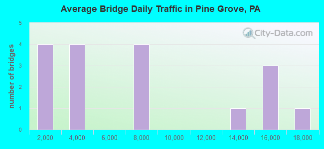
- 111,174Total average daily traffic
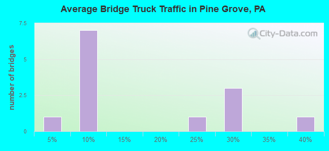
- 22,208Total average daily truck traffic
- National Bridge Inventory (NBI) Registered Bridges for Pine Grove
- No street view available for this location
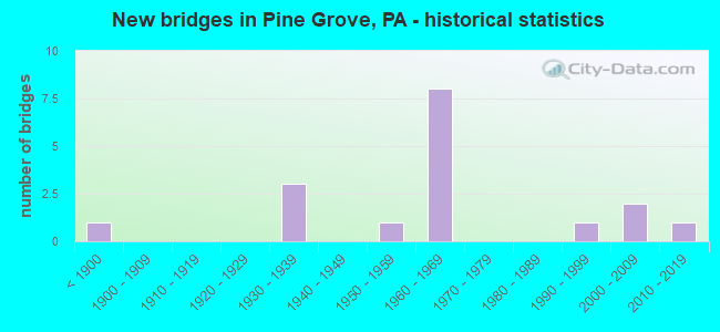
- New bridges - historical statistics
- 1Before 1900
- 31930-1939
- 11950-1959
- 81960-1969
- 11990-1999
- 22000-2009
- 12010-2019
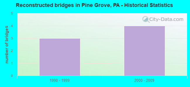
- Reconstructed bridges - Historical Statistics
- 31990-1999
- 42000-2009
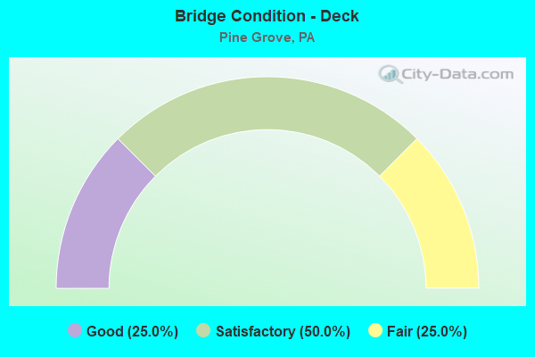
- Bridge Condition - Deck
- 25.0%Good
- 50.0%Satisfactory
- 25.0%Fair
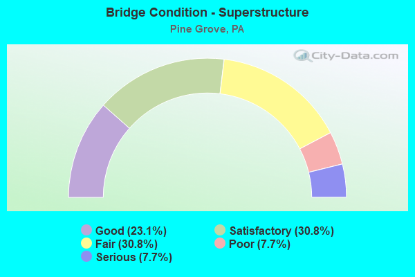
- Bridge Condition - Superstructure
- 23.1%Good
- 30.8%Satisfactory
- 30.8%Fair
- 7.7%Poor
- 7.7%Serious
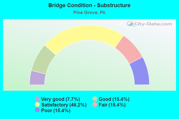
- Bridge Condition - Substructure
- 7.7%Very good
- 15.4%Good
- 46.2%Satisfactory
- 15.4%Fair
- 15.4%Poor
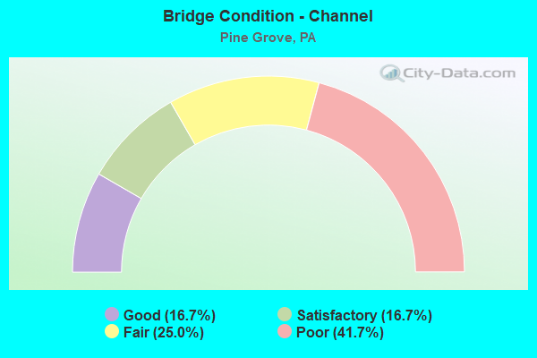
- Bridge Condition - Channel
- 16.7%Good
- 16.7%Satisfactory
- 25.0%Fair
- 41.7%Poor
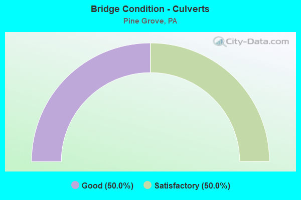
- Bridge Condition - Culverts
- 50.0%Good
- 50.0%Satisfactory
Find on map >> Show street view
Structure Number: 31, Location: E OF YORK SPRINGS (Lat: 40.000975, Lng: -77.105742), Route carried "on" structure: US 15, Year Built: 1957, Year Reconstructed: 2001, Status: Open, Structure Length: 4.15m (13.62ft), Average Daily Traffic: 17,930 (year 2021), Truck Traffic: 21%, Average Future Daily Traffic: 24,080 (year 2032), Design Load: HS 20, Features Intersected: PA 94; SR 0094
Minimum Vertical Clearance: 30+ m (98+ ft), Kilometerpoint: 37.934, Lanes on structure: 4, Lanes under structure: 4, Base Highway Network: Yes, Owner: State Highway Agency, Approaching Roadway Width: 26.5m (86.9ft), Skew: 20 degrees, Material/Design: Steel continuous, Design/Construction: Stringer/Multi-beam, Number Of Spans In Main Unit: 3, Length of Maximum Span: 21.6m (70.9ft), Curb-To-Curb Width: 25.8m (84.6ft), Out-to-Out Width: 26.7m (87.6ft)
Condition: Deck: Good, Superstructure: Good, Substructure: Good, Operating Rating: 97.1 metric tons, Method Used To Determine Operating Rating: Load Factor (LF), Inventory Rating: 58.1 metric tons, Method Used To Determine Inventory Rating: Load Factor (LF), Structural Evaluation: Better than present minimum criteria, Deck Geometry: Superior to present desirable criteria, Underclear: Meets minimum limits, Approach Roadway Alignment: Equal to present minimum criteria, Length Of Structure Improvement: 4.30m (14.11ft), Designated Inspection Frequency: Every 24 months, Inspection Date: June 2021, Bridge Improvement Cost: $127,000, Roadway Improvement Cost: $375,000, Total Project Cost: $1,717,000, Deck Structure Type: Concrete Cast-file-Place, Wearing Surface/Protective System: Wearing Surface: Monolithic Concrete, Deck Protection: Epoxy Coated Reinforcing
Find on map >> Show street view
Structure Number: 30551, Location: 0.5 MI. S. EXIT 100 (31) (Lat: 40.526658, Lng: -76.433369), Route carried "on" structure: Interstate 81, Year Built: 1968, Year Reconstructed: 2000, Status: Open, Structure Length: 7.16m (23.49ft), Average Daily Traffic: 14,294 (year 2021), Truck Traffic: 27%, Average Future Daily Traffic: 21,335 (year 2032), Design Load: HS 20+Mod, Features Intersected: SWATARA CREEK
Minimum Vertical Clearance: 30+ m (98+ ft), Kilometerpoint: 3.586, Lanes on structure: 2, Base Highway Network: Yes, Owner: State Highway Agency, Approaching Roadway Width: 12.2m (40.0ft), Skew: 13 degrees, Material/Design: Prestressed concrete, Design/Construction: Box Beam or Girders - Single/Spread, Number Of Spans In Main Unit: 4, Length of Maximum Span: 17.7m (58.1ft), Curb or Sidewalk Widths: Left: 0.2m (0.7ft), Right: 0.2m (0.7ft), Curb-To-Curb Width: 9.4m (30.8ft), Out-to-Out Width: 11.1m (36.4ft)
Condition: Deck: Good, Superstructure: Satisfactory, Substructure: Satisfactory, Channel: Fair, Operating Rating: 40.8 metric tons, Method Used To Determine Operating Rating: Load Factor (LF), Inventory Rating: 24.5 metric tons, Method Used To Determine Inventory Rating: Load Factor (LF), Structural Evaluation: Equal to present minimum criteria, Deck Geometry: Meets minimum limits, Waterway Adequacy: Better than present minimum criteria, Approach Roadway Alignment: Equal to present desirable criteria, Length Of Structure Improvement: 8.70m (28.54ft), Designated Inspection Frequency: Every 24 months, Underwater Inspection Frequency: Every 60 months, Inspection Date: October 2020, Underwater Inspection Date: August 2020, Bridge Improvement Cost: $111,000, Roadway Improvement Cost: $326,000, Total Project Cost: $1,495,000, Deck Structure Type: Concrete Cast-file-Place, Wearing Surface/Protective System: Wearing Surface: Latex Concrete
Find on map >> Show street view
Structure Number: 30552, Location: 0.5 MI. S. EXIT 100 (31) (Lat: 40.526894, Lng: -76.434153), Route carried "on" structure: Interstate 81, Year Built: 1968, Year Reconstructed: 2000, Status: Open, Structure Length: 7.16m (23.49ft), Average Daily Traffic: 14,230 (year 2021), Truck Traffic: 25%, Average Future Daily Traffic: 17,705 (year 2032), Design Load: HS 20+Mod, Features Intersected: SWATARA CREEK
Minimum Vertical Clearance: 30+ m (98+ ft), Kilometerpoint: 3.478, Lanes on structure: 2, Base Highway Network: Yes, Owner: State Highway Agency, Approaching Roadway Width: 12.5m (41.0ft), Skew: 13 degrees, Material/Design: Prestressed concrete, Design/Construction: Box Beam or Girders - Single/Spread, Number Of Spans In Main Unit: 4, Length of Maximum Span: 17.7m (58.1ft), Curb or Sidewalk Widths: Left: 0.2m (0.7ft), Right: 0.2m (0.7ft), Curb-To-Curb Width: 9.4m (30.8ft), Out-to-Out Width: 11.1m (36.4ft)
Condition: Deck: Satisfactory, Superstructure: Satisfactory, Substructure: Satisfactory, Channel: Fair, Operating Rating: 40.8 metric tons, Method Used To Determine Operating Rating: Load Factor (LF), Inventory Rating: 24.5 metric tons, Method Used To Determine Inventory Rating: Load Factor (LF), Structural Evaluation: Equal to present minimum criteria, Deck Geometry: Meets minimum limits, Waterway Adequacy: Better than present minimum criteria, Approach Roadway Alignment: Equal to present desirable criteria, Length Of Structure Improvement: 8.70m (28.54ft), Designated Inspection Frequency: Every 24 months, Underwater Inspection Frequency: Every 60 months, Inspection Date: October 2020, Underwater Inspection Date: August 2020, Bridge Improvement Cost: $111,000, Roadway Improvement Cost: $326,000, Total Project Cost: $1,495,000, Deck Structure Type: Concrete Cast-file-Place, Wearing Surface/Protective System: Wearing Surface: Latex Concrete
Find on map >> Show street view
Structure Number: 30553, Location: EXIT 100 (31) (Lat: 40.534306, Lng: -76.428658), Route carried "on" structure: Interstate 81, Year Built: 1968, Year Reconstructed: 2000, Status: Open, Structure Length: 3.32m (10.89ft), Average Daily Traffic: 12,745 (year 2021), Truck Traffic: 37%, Average Future Daily Traffic: 21,335 (year 2032), Design Load: HS 20+Mod, Features Intersected: PA 443 (LR 140)
Minimum Vertical Clearance: 30+ m (98+ ft), Kilometerpoint: 4.394, Lanes on structure: 2, Lanes under structure: 2, Base Highway Network: Yes, Owner: State Highway Agency, Approaching Roadway Width: 11.9m (39.0ft), Skew: 12 degrees, Material/Design: Prestressed concrete, Design/Construction: Box Beam or Girders - Single/Spread, Number Of Spans In Main Unit: 3, Length of Maximum Span: 14.9m (48.9ft), Curb or Sidewalk Widths: Left: 0.2m (0.7ft), Right: 0.2m (0.7ft), Curb-To-Curb Width: 11.7m (38.4ft), Out-to-Out Width: 13.0m (42.7ft)
Condition: Deck: Satisfactory, Superstructure: Fair, Substructure: Satisfactory, Operating Rating: 45.4 metric tons, Method Used To Determine Operating Rating: Load Factor (LF), Inventory Rating: 25.4 metric tons, Method Used To Determine Inventory Rating: Load Factor (LF), Structural Evaluation: Somewhat better than minimum adequacy, Deck Geometry: Equal to present minimum criteria, Underclear: Somewhat better than minimum adequacy, Approach Roadway Alignment: Equal to present desirable criteria, Length Of Structure Improvement: 4.20m (13.78ft), Designated Inspection Frequency: Every 24 months, Inspection Date: September 2020, Bridge Improvement Cost: $50,000, Roadway Improvement Cost: $147,000, Total Project Cost: $673,000, Deck Structure Type: Concrete Cast-file-Place, Wearing Surface/Protective System: Wearing Surface: Latex Concrete
Find on map >> Show street view
Structure Number: 30554, Location: EXIT 100 ( 31) (Lat: 40.534117, Lng: -76.429203), Route carried "on" structure: Interstate 81, Year Built: 1968, Year Reconstructed: 2000, Status: Open, Structure Length: 3.54m (11.61ft), Average Daily Traffic: 14,230 (year 2021), Truck Traffic: 25%, Average Future Daily Traffic: 17,705 (year 2032), Design Load: HS 20+Mod, Features Intersected: PA 443 (LR 140)
Minimum Vertical Clearance: 30+ m (98+ ft), Kilometerpoint: 4.297, Lanes on structure: 3, Lanes under structure: 2, Base Highway Network: Yes, Owner: State Highway Agency, Approaching Roadway Width: 16.2m (53.1ft), Skew: 12 degrees, Material/Design: Prestressed concrete, Design/Construction: Box Beam or Girders - Single/Spread, Number Of Spans In Main Unit: 3, Length of Maximum Span: 16.2m (53.1ft), Curb or Sidewalk Widths: Left: 0.2m (0.7ft), Right: 0.2m (0.7ft), Curb-To-Curb Width: 15.7m (51.5ft), Out-to-Out Width: 16.9m (55.4ft)
Condition: Deck: Satisfactory, Superstructure: Fair, Substructure: Satisfactory, Operating Rating: 64.4 metric tons, Method Used To Determine Operating Rating: Load Factor (LF), Inventory Rating: 26.3 metric tons, Method Used To Determine Inventory Rating: Load Factor (LF), Structural Evaluation: Somewhat better than minimum adequacy, Deck Geometry: Somewhat better than minimum adequacy, Underclear: Somewhat better than minimum adequacy, Approach Roadway Alignment: Equal to present desirable criteria, Length Of Structure Improvement: 4.10m (13.45ft), Designated Inspection Frequency: Every 24 months, Inspection Date: September 2020, Bridge Improvement Cost: $110,000, Roadway Improvement Cost: $324,000, Total Project Cost: $1,485,000, Deck Structure Type: Concrete Cast-file-Place, Wearing Surface/Protective System: Wearing Surface: Latex Concrete
Find on map >> Show street view
Structure Number: 30683, Location: AT I-81 INTERCHANGE (Lat: 40.534681, Lng: -76.427036), Route carried "on" structure: State highway 443, Year Built: 1968, Status: Open, Structure Length: 0.94m (3.08ft), Average Daily Traffic: 6,173 (year 2020), Truck Traffic: 8%, Average Future Daily Traffic: 7,021 (year 2032), Design Load: HS 20, Features Intersected: TRIB. TO SWATARA CREEK
Minimum Vertical Clearance: 30+ m (98+ ft), Kilometerpoint: 5.277, Lanes on structure: 2, Base Highway Network: Yes, Owner: State Highway Agency, Approaching Roadway Width: 15.2m (49.9ft), Material/Design: Concrete, Design/Construction: Slab, Number Of Spans In Main Unit: 1, Length of Maximum Span: 8.8m (28.9ft), Curb-To-Curb Width: 15.4m (50.5ft), Out-to-Out Width: 16.5m (54.1ft)
Condition: Deck: Satisfactory, Superstructure: Satisfactory, Substructure: Satisfactory, Channel: Fair, Operating Rating: 69.9 metric tons, Method Used To Determine Operating Rating: Load Factor (LF), Inventory Rating: 41.7 metric tons, Method Used To Determine Inventory Rating: Load Factor (LF), Structural Evaluation: Equal to present minimum criteria, Deck Geometry: Superior to present desirable criteria, Waterway Adequacy: Somewhat better than minimum adequacy, Approach Roadway Alignment: Equal to present desirable criteria, Length Of Structure Improvement: 1.60m (5.25ft), Designated Inspection Frequency: Every 24 months, Inspection Date: October 2019, Wearing Surface/Protective System: Wearing Surface: Monolithic Concrete
Find on map >> Show street view
Structure Number: 30684, Location: EAST SIDE OF PINE GROVE (Lat: 40.554536, Lng: -76.381744), Route carried "on" structure: State highway 443, Year Built: 1968, Status: Open, Structure Length: 3.96m (12.99ft), Average Daily Traffic: 6,340 (year 2022), Truck Traffic: 7%, Average Future Daily Traffic: 6,946 (year 2032), Design Load: HS 20, Features Intersected: SWATARA CREEK
Minimum Vertical Clearance: 30+ m (98+ ft), Kilometerpoint: 10.495, Lanes on structure: 2, Base Highway Network: Yes, Owner: State Highway Agency, Approaching Roadway Width: 10.7m (35.1ft), Skew: 3 degrees, Material/Design: Prestressed concrete, Design/Construction: Box Beam or Girders - Single/Spread, Number Of Spans In Main Unit: 3, Length of Maximum Span: 13.4m (44.0ft), Curb or Sidewalk Widths: Left: 1.5m (4.9ft), Right: 1.5m (4.9ft), Curb-To-Curb Width: 12.2m (40.0ft), Out-to-Out Width: 16.0m (52.5ft)
Condition: Deck: Fair, Superstructure: Satisfactory, Substructure: Satisfactory, Channel: Poor, Operating Rating: 56.2 metric tons, Method Used To Determine Operating Rating: Load Factor (LF), Inventory Rating: 33.6 metric tons, Method Used To Determine Inventory Rating: Load Factor (LF), Structural Evaluation: Equal to present minimum criteria, Deck Geometry: Somewhat better than minimum adequacy, Waterway Adequacy: Equal to present minimum criteria, Approach Roadway Alignment: Better than present minimum criteria, Length Of Structure Improvement: 4.80m (15.75ft), Designated Inspection Frequency: Every 24 months, Inspection Date: October 2019, Deck Structure Type: Concrete Cast-file-Place, Wearing Surface/Protective System: Wearing Surface: Epoxy Overlay, Membrane: Epoxy
Find on map >> Show street view
Structure Number: 30706, Location: PINE GROVE BORO LINE (Lat: 40.543281, Lng: -76.382897), Route carried "on" structure: State highway 895, Year Built: 1934, Status: Open, Structure Length: 3.99m (13.09ft), Average Daily Traffic: 3,277 (year 2020), Truck Traffic: 8%, Average Future Daily Traffic: 4,196 (year 2032), Features Intersected: SWATARA CREEK
Minimum Vertical Clearance: 30+ m (98+ ft), Kilometerpoint: 0.000, Lanes on structure: 2, Owner: State Highway Agency, Approaching Roadway Width: 7.3m (24.0ft), Skew: 1 degrees, Material/Design: Concrete, Design/Construction: Arch - Deck, Number Of Spans In Main Unit: 2, Length of Maximum Span: 19.5m (64.0ft), Curb-To-Curb Width: 7.6m (24.9ft), Out-to-Out Width: 8.4m (27.6ft)
Condition: Superstructure: Fair, Substructure: Fair, Channel: Poor, Operating Rating: 51.7 metric tons, Method Used To Determine Operating Rating: Allowable Stress (AS), Inventory Rating: 35.4 metric tons, Method Used To Determine Inventory Rating: Allowable Stress (AS), Structural Evaluation: Somewhat better than minimum adequacy, Deck Geometry: High priority of replacement, Waterway Adequacy: Equal to present desirable criteria, Approach Roadway Alignment: Equal to present desirable criteria, Length Of Structure Improvement: 4.80m (15.75ft), Designated Inspection Frequency: Every 24 months, Inspection Date: October 2019, Bridge Improvement Cost: $19,000, Roadway Improvement Cost: $57,000, Total Project Cost: $260,000
Find on map >> Show street view
Structure Number: 30922, Location: S.OF SR 895,E.OF SR 501 (Lat: 40.540094, Lng: -76.357028), Route carried "on" structure: City street , Year Built: 1932, Status: Open, Structure Length: 2.07m (6.79ft), Average Daily Traffic: 150 (year 1980), Truck Traffic: 1%, Average Future Daily Traffic: 150 (year 2000), Design Load: HS 20, Features Intersected: LOW. LIT. SWATARA CREEK, Facility Carried by Structure: T-654 CAMP ROAD
Minimum Vertical Clearance: 30+ m (98+ ft), Kilometerpoint: 0.000, Lanes on structure: 2, Owner: County Highway Agency, Approaching Roadway Width: 5.5m (18.0ft), Material/Design: Concrete, Design/Construction: Tee Beam, Number Of Spans In Main Unit: 2, Length of Maximum Span: 9.4m (30.8ft), Curb-To-Curb Width: 6.2m (20.3ft), Out-to-Out Width: 7.1m (23.3ft)
Condition: Deck: Fair, Superstructure: Fair, Substructure: Poor, Channel: Poor, Operating Rating: 54.4 metric tons, Method Used To Determine Operating Rating: Load Factor (LF), Inventory Rating: 32.7 metric tons, Method Used To Determine Inventory Rating: Load Factor (LF), Structural Evaluation: Meets minimum limits, Deck Geometry: Meets minimum limits, Waterway Adequacy: Equal to present minimum criteria, Approach Roadway Alignment: Somewhat better than minimum adequacy, Length Of Structure Improvement: 2.30m (7.55ft), Designated Inspection Frequency: Every 24 months, Underwater Inspection Frequency: Every 24 months, Inspection Date: September 2021, Underwater Inspection Date: July 2020, Bridge Improvement Cost: $5,000, Roadway Improvement Cost: $26,000, Total Project Cost: $65,000, Deck Structure Type: Concrete Cast-file-Place, Wearing Surface/Protective System: Wearing Surface: Bituminous
Find on map >> Show street view
Structure Number: 30953, Location: 0.1 MI SOUTH OF SR 895 (Lat: 40.544097, Lng: -76.325561), Route carried "on" structure: City street , Year Built: 1860, Year Reconstructed: 1997, Status: Posted for load, Structure Length: 1.98m (6.50ft), Average Daily Traffic: 50 (year 1980), Average Future Daily Traffic: 250 (year 2030), Design Load: H 10, Features Intersected: LOWER LITTLE SWATARA CR, Facility Carried by Structure: COVERED BRIDGE RD
Minimum Vertical Clearance: 2.90m (9.51ft), Kilometerpoint: 0.000, Lanes on structure: 1, Owner: County Highway Agency, Approaching Roadway Width: 4.3m (14.1ft), Material/Design: Wood or Timber, Design/Construction: Truss - Thru, Number Of Spans In Main Unit: 1, Length of Maximum Span: 15.2m (49.9ft), Curb-To-Curb Width: 3.5m (11.5ft), Out-to-Out Width: 4.4m (14.4ft)
Condition: Deck: Satisfactory, Superstructure: Serious, Substructure: Fair, Channel: Poor, Operating Rating: 14.5 metric tons, Method Used To Determine Operating Rating: Load Factor (LF), Inventory Rating: 10.0 metric tons, Method Used To Determine Inventory Rating: Load Factor (LF), Structural Evaluation: High priority of replacement, Deck Geometry: High priority of replacement, Waterway Adequacy: Better than present minimum criteria, Approach Roadway Alignment: Somewhat better than minimum adequacy, Bridge Posting: Required (Relationship of Operating Rating to Maximum Legal Load: > 39.9% below), Length Of Structure Improvement: 1.60m (5.25ft), Designated Inspection Frequency: Every 24 months, Other Special Inspection Frequency: Every 6 months, Inspection Date: April 2020, Other Special Inspection Date: October 2021, Bridge Improvement Cost: $19,000, Roadway Improvement Cost: $56,000, Total Project Cost: $257,000, Deck Structure Type: Wood or Timber, Wearing Surface/Protective System: Wearing Surface: Wood or Timber
Find on map >> Show street view
Structure Number: 31, Location: E MILL ST. IN PINE GROVE (Lat: 40.548822, Lng: -76.379803), Route carried "on" structure: City street , Year Built: 1939, Year Reconstructed: 1998, Status: Open, Structure Length: 4.45m (14.60ft), Average Daily Traffic: 300 (year 1980), Average Future Daily Traffic: 420 (year 2000), Design Load: HS 25 or greater, Features Intersected: SWATARA CREEK, Facility Carried by Structure: E MILL ST
Minimum Vertical Clearance: 30+ m (98+ ft), Kilometerpoint: 0.000, Lanes on structure: 2, Owner: County Highway Agency, Approaching Roadway Width: 7.3m (24.0ft), Material/Design: Concrete, Design/Construction: Tee Beam, Number Of Spans In Main Unit: 3, Length of Maximum Span: 14.3m (46.9ft), Curb or Sidewalk Widths: Left: 1.8m (5.9ft), Right: 1.8m (5.9ft), Curb-To-Curb Width: 7.0m (23.0ft), Out-to-Out Width: 11.2m (36.7ft)
Condition: Deck: Fair, Superstructure: Poor, Substructure: Poor, Channel: Poor, Operating Rating: 57.2 metric tons, Method Used To Determine Operating Rating: Load Factor (LF), Inventory Rating: 34.5 metric tons, Method Used To Determine Inventory Rating: Load Factor (LF), Structural Evaluation: Meets minimum limits, Deck Geometry: Meets minimum limits, Waterway Adequacy: Equal to present desirable criteria, Approach Roadway Alignment: Equal to present desirable criteria, Length Of Structure Improvement: 5.40m (17.72ft), Designated Inspection Frequency: Every 24 months, Inspection Date: May 2020, Bridge Improvement Cost: $65,000, Roadway Improvement Cost: $192,000, Total Project Cost: $880,000, Deck Structure Type: Concrete Cast-file-Place, Wearing Surface/Protective System: Wearing Surface: Integral Concrete, Membrane: Epoxy
Find on map >> Show street view
Structure Number: 40602, Location: 0.2 MI. S. OF MARSTOWN (Lat: 40.537197, Lng: -76.378011), Route carried "on" structure: State highway 501, Year Built: 1999, Status: Open, Structure Length: 3.47m (11.38ft), Average Daily Traffic: 3,830 (year 2021), Truck Traffic: 9%, Average Future Daily Traffic: 3,402 (year 2032), Design Load: HS 25 or greater, Features Intersected: LITTLE SWATARA CREEK
Minimum Vertical Clearance: 30+ m (98+ ft), Kilometerpoint: 3.867, Lanes on structure: 2, Owner: State Highway Agency, Approaching Roadway Width: 11.0m (36.1ft), Material/Design: Prestressed concrete continuous, Design/Construction: Box Beam or Girders - Multiple, Number Of Spans In Main Unit: 2, Length of Maximum Span: 17.1m (56.1ft), Curb or Sidewalk Widths: Left: 0.2m (0.7ft), Right: 0.2m (0.7ft), Curb-To-Curb Width: 11.5m (37.7ft), Out-to-Out Width: 12.3m (40.4ft)
Condition: Deck: Satisfactory, Superstructure: Good, Substructure: Good, Channel: Good, Operating Rating: 89.8 metric tons, Method Used To Determine Operating Rating: Load Factor (LF), Inventory Rating: 45.4 metric tons, Method Used To Determine Inventory Rating: Load Factor (LF), Structural Evaluation: Better than present minimum criteria, Deck Geometry: Somewhat better than minimum adequacy, Waterway Adequacy: Superior to present desirable criteria, Approach Roadway Alignment: Equal to present desirable criteria, Length Of Structure Improvement: 4.40m (14.44ft), Designated Inspection Frequency: Every 48 months, Inspection Date: October 2019, Deck Structure Type: Concrete Cast-file-Place, Wearing Surface/Protective System: Wearing Surface: Monolithic Concrete, Deck Protection: Epoxy Coated Reinforcing
Find on map >> Show street view
Structure Number: 41282, Location: W.OF SR 645,S.OF SR 443 (Lat: 40.520933, Lng: -76.391336), Route carried "on" structure: City street , Year Built: 2001, Status: Open, Structure Length: 1.28m (4.20ft), Average Daily Traffic: 2,000 (year 2018), Average Future Daily Traffic: 2,440 (year 2038), Design Load: HL 93, Features Intersected: SWOPE VALLEY RUN, Facility Carried by Structure: T-649 SWOPE VAL.RD
Minimum Vertical Clearance: 30+ m (98+ ft), Kilometerpoint: 0.000, Lanes on structure: 2, Owner: Town or Township Highway Agency, Approaching Roadway Width: 8.8m (28.9ft), Skew: 4 degrees, Material/Design: Concrete, Design/Construction: Culvert, Number Of Spans In Main Unit: 2, Length of Maximum Span: 5.5m (18.0ft), Curb-To-Curb Width: 9.0m (29.5ft), Out-to-Out Width: 10.1m (33.1ft)
Condition: Channel: Satisfactory, Culverts: Satisfactory, Operating Rating: 77.1 metric tons, Method Used To Determine Operating Rating: Load Factor (LF), Inventory Rating: 46.3 metric tons, Method Used To Determine Inventory Rating: Load Factor (LF), Structural Evaluation: Equal to present minimum criteria, Deck Geometry: Somewhat better than minimum adequacy, Waterway Adequacy: Better than present minimum criteria, Approach Roadway Alignment: Equal to present desirable criteria, Designated Inspection Frequency: Every 24 months, Inspection Date: May 2020, Deck Structure Type: Concrete Cast-file-Place, Wearing Surface/Protective System: Wearing Surface: Monolithic Concrete
Find on map >> Show street view
Structure Number: 48266, Location: SOUTH OF PINE GROVE (Lat: 40.537039, Lng: -76.389133), Route carried "on" structure: State highway 645, Year Built: 2013, Status: Open, Structure Length: 4.97m (16.31ft), Average Daily Traffic: 3,229 (year 2020), Truck Traffic: 7%, Average Future Daily Traffic: 3,155 (year 2039), Design Load: HL 93, Features Intersected: SWATARA CREEK
Minimum Vertical Clearance: 30+ m (98+ ft), Kilometerpoint: 3.404, Lanes on structure: 2, Owner: State Highway Agency, Approaching Roadway Width: 8.5m (27.9ft), Material/Design: Prestressed concrete, Design/Construction: Stringer/Multi-beam, Number Of Spans In Main Unit: 2, Length of Maximum Span: 24.4m (80.1ft), Curb or Sidewalk Widths: Left: 0.1m (0.3ft), Right: 0.1m (0.3ft), Curb-To-Curb Width: 8.7m (28.5ft), Out-to-Out Width: 9.8m (32.2ft)
Condition: Deck: Good, Superstructure: Good, Substructure: Very good, Channel: Satisfactory, Operating Rating: 46.7 metric tons, Method Used To Determine Operating Rating: Assigned ratings based on Load and Resistance Factor Design (LRFD) reported by rating factor (RF) using HL93 loadings, Inventory Rating: 36.0 metric tons, Method Used To Determine Inventory Rating: Assigned ratings based on Load and Resistance Factor Design (LRFD) reported by rating factor (RF) using HL93 loadings, Structural Evaluation: Better than present minimum criteria, Deck Geometry: Meets minimum limits, Waterway Adequacy: Somewhat better than minimum adequacy, Approach Roadway Alignment: Better than present minimum criteria, Designated Inspection Frequency: Every 48 months, Inspection Date: November 2019, Deck Structure Type: Concrete Cast-file-Place, Wearing Surface/Protective System: Wearing Surface: Monolithic Concrete, Deck Protection: Epoxy Coated Reinforcing
Find on map >> Show street view
Structure Number: 56928, Location: 0.3 MI W OF PA645 (Lat: 40.533500, Lng: -76.393833), Route carried "on" structure: City street , Year Built: 2009, Status: Open, Structure Length: 0.88m (2.89ft), Average Daily Traffic: 50 (year 2020), Average Future Daily Traffic: 75 (year 2040), Design Load: HL 93, Features Intersected: Swopes Valley Run, Facility Carried by Structure: Roberts Road
Minimum Vertical Clearance: 30+ m (98+ ft), Kilometerpoint: 0.000, Lanes on structure: 2, Owner: Town or Township Highway Agency, Approaching Roadway Width: 7.0m (23.0ft), Skew: 3 degrees, Material/Design: Concrete, Design/Construction: Culvert, Number Of Spans In Main Unit: 1, Length of Maximum Span: 7.6m (24.9ft), Curb-To-Curb Width: 7.6m (24.9ft), Out-to-Out Width: 8.5m (27.9ft)
Condition: Channel: Good, Culverts: Good, Operating Rating: 49.9 metric tons, Method Used To Determine Operating Rating: Load Factor (LF), Inventory Rating: 29.9 metric tons, Method Used To Determine Inventory Rating: Load Factor (LF), Structural Evaluation: Better than present minimum criteria, Deck Geometry: Equal to present minimum criteria, Waterway Adequacy: Better than present minimum criteria, Approach Roadway Alignment: Equal to present desirable criteria, Designated Inspection Frequency: Every 24 months, Inspection Date: November 2020
Find on map >> Show street view
Structure Number: 30553, Location: EXIT 100 (31) (Lat: 40.534306, Lng: -76.428658), Route carried "under" structure: State highway 443, Year Built: 1968, Structure Length: 0. m, Average Daily Traffic: 6,173 (year 2020), Truck Traffic: 8%, Features Intersected: PA 443 (LR 140), Facility Carried by Structure: I-81NB (LR1005)
Minimum Vertical Clearance: 4.39m (14.40ft), Kilometerpoint: 5.277, Lanes on structure: 2, Lanes under structure: 2, Material/Design: Prestressed concrete, Design/Construction: Box Beam or Girders - Single/Spread, Length of Maximum Span: 14.9m (48.9ft)
Find on map >> Show street view
Structure Number: 30554, Location: EXIT 100 ( 31) (Lat: 40.534117, Lng: -76.429203), Route carried "under" structure: State highway 443, Year Built: 1968, Structure Length: 0. m, Average Daily Traffic: 6,173 (year 2020), Truck Traffic: 8%, Features Intersected: PA 443 (LR 140), Facility Carried by Structure: I-81 SB (LR 1005)
Minimum Vertical Clearance: 4.57m (14.99ft), Kilometerpoint: 5.277, Lanes on structure: 3, Lanes under structure: 2, Material/Design: Prestressed concrete, Design/Construction: Box Beam or Girders - Single/Spread, Length of Maximum Span: 16.2m (53.1ft)