Bridge Statistics for Pineville, North Carolina (NC)
Condition, Traffic, Stress, Structural Evaluation, Project Costs
- National Bridge Inventory (NBI) Statistics
- 15Number of bridges
- 194ft / 59.2mTotal length
- 442,850Total average daily traffic
- 57,357Total average daily truck traffic
- National Bridge Inventory (NBI) Registered Bridges for Pineville
- No street view available for this location
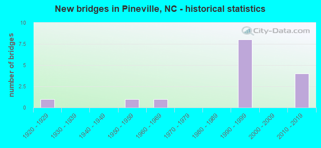
- New bridges - historical statistics
- 11920-1929
- 11950-1959
- 11960-1969
- 81990-1999
- 42010-2019
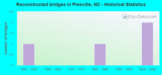
- Reconstructed bridges - Historical Statistics
- 11950-1959
- 01960-1969
- 01970-1979
- 11980-1989
- 01990-1999
- 22000-2009
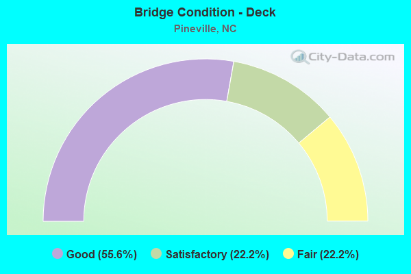
- Bridge Condition - Deck
- 55.6%Good
- 22.2%Satisfactory
- 22.2%Fair
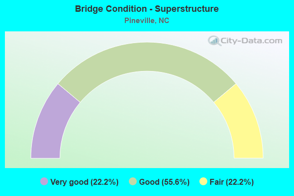
- Bridge Condition - Superstructure
- 22.2%Very good
- 55.6%Good
- 22.2%Fair
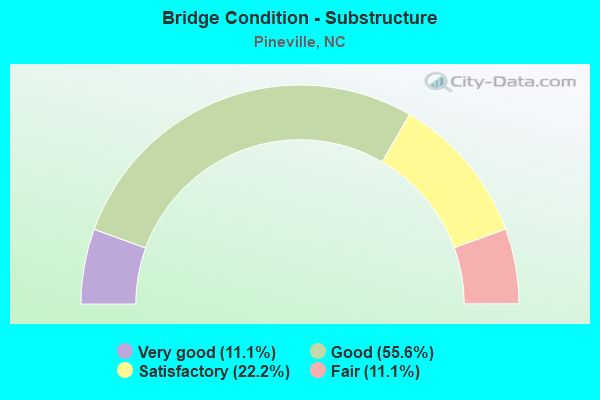
- Bridge Condition - Substructure
- 11.1%Very good
- 55.6%Good
- 22.2%Satisfactory
- 11.1%Fair
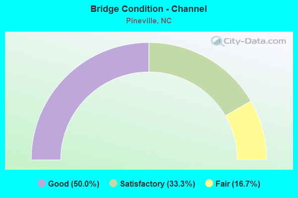
- Bridge Condition - Channel
- 50.0%Good
- 33.3%Satisfactory
- 16.7%Fair
Find on map >> Show street view
Structure Number: 1190017, Location: 0.6 MI. S. JCT. SR3637 (Lat: 35.062808, Lng: -80.876944), Route carried "on" structure: State highway 4982, Year Built: 1926, Year Reconstructed: 1961, Status: Open, Structure Length: 6.40m (21.00ft), Average Daily Traffic: 22,000 (year 2012), Truck Traffic: 6%, Average Future Daily Traffic: 44,000 (year 2040), Design Load: H 15, Features Intersected: MCALPINE CREEK
Minimum Vertical Clearance: 30+ m (98+ ft), Kilometerpoint: 0.000, Lanes on structure: 2, Base Highway Network: Yes, Owner: State Highway Agency, Approaching Roadway Width: 8.5m (27.9ft), Material/Design: Concrete, Design/Construction: Tee Beam, Number Of Spans In Main Unit: 4, Length of Maximum Span: 15.5m (50.9ft), Curb or Sidewalk Widths: Left: 0.4m (1.3ft), Right: 0.4m (1.3ft), Curb-To-Curb Width: 8.5m (27.9ft), Out-to-Out Width: 9.5m (31.2ft)
Condition: Deck: Satisfactory, Superstructure: Fair, Substructure: Satisfactory, Channel: Good, Operating Rating: 39.0 metric tons, Method Used To Determine Operating Rating: Load Factor (LF), Inventory Rating: 22.6 metric tons, Method Used To Determine Inventory Rating: Load Factor (LF), Structural Evaluation: Somewhat better than minimum adequacy, Deck Geometry: Meets minimum limits, Waterway Adequacy: Better than present minimum criteria, Approach Roadway Alignment: Equal to present desirable criteria, Designated Inspection Frequency: Every 24 months, Inspection Date: September 2020, Deck Structure Type: Concrete Cast-file-Place, Wearing Surface/Protective System: Wearing Surface: Bituminous
Find on map >> Show street view
Structure Number: 1190025, Location: 50 FT. N. JCT. SR3645 (Lat: 35.090650, Lng: -80.899350), Route carried "on" structure: State highway 51, Year Built: 1968, Status: Open, Structure Length: 5.05m (16.57ft), Average Daily Traffic: 20,000 (year 2014), Truck Traffic: 6%, Average Future Daily Traffic: 40,000 (year 2040), Design Load: HS 20+Mod, Features Intersected: SUGAR CREEK
Minimum Vertical Clearance: 30+ m (98+ ft), Kilometerpoint: 0.000, Lanes on structure: 2, Owner: State Highway Agency, Approaching Roadway Width: 12.8m (42.0ft), Material/Design: Prestressed concrete, Design/Construction: Stringer/Multi-beam, Number Of Spans In Main Unit: 3, Length of Maximum Span: 16.4m (53.8ft), Curb or Sidewalk Widths: Left: 0.9m (3.0ft), Right: 0.9m (3.0ft), Curb-To-Curb Width: 12.1m (39.7ft), Out-to-Out Width: 14.7m (48.2ft)
Condition: Deck: Fair, Superstructure: Good, Substructure: Satisfactory, Channel: Good, Operating Rating: 89.8 metric tons, Method Used To Determine Operating Rating: Load Factor (LF), Inventory Rating: 48.9 metric tons, Method Used To Determine Inventory Rating: Load Factor (LF), Structural Evaluation: Equal to present minimum criteria, Deck Geometry: Somewhat better than minimum adequacy, Waterway Adequacy: Better than present minimum criteria, Approach Roadway Alignment: Equal to present desirable criteria, Designated Inspection Frequency: Every 24 months, Inspection Date: August 2020, Deck Structure Type: Concrete Cast-file-Place, Wearing Surface/Protective System: Wearing Surface: Monolithic Concrete
Find on map >> Show street view
Structure Number: 1190049, Location: 0.25 MI. N. JCT. SR3640 (Lat: 35.079453, Lng: -80.885242), Route carried "on" structure: State highway 4982, Year Built: 2016, Status: Open, Structure Length: 5.48m (17.98ft), Average Daily Traffic: 14,500 (year 2018), Truck Traffic: 6%, Average Future Daily Traffic: 29,000 (year 2040), Design Load: HL 93, Features Intersected: LITTLE SUGAR CREEK
Minimum Vertical Clearance: 30+ m (98+ ft), Kilometerpoint: 0.000, Lanes on structure: 2, Base Highway Network: Yes, Owner: State Highway Agency, Approaching Roadway Width: 12.1m (39.7ft), Material/Design: Prestressed concrete continuous, Design/Construction: Stringer/Multi-beam, Number Of Spans In Main Unit: 3, Length of Maximum Span: 20.4m (66.9ft), Curb or Sidewalk Widths: Left: 1.6m (5.2ft), Right: 1.6m (5.2ft), Curb-To-Curb Width: 13.4m (44.0ft), Out-to-Out Width: 17.5m (57.4ft)
Condition: Deck: Good, Superstructure: Very good, Substructure: Good, Channel: Satisfactory, Operating Rating: 58.9 metric tons, Method Used To Determine Operating Rating: Load and Resistance Factor (LRFR), Inventory Rating: 45.3 metric tons, Method Used To Determine Inventory Rating: Load and Resistance Factor (LRFR), Structural Evaluation: Better than present minimum criteria, Deck Geometry: Equal to present minimum criteria, Waterway Adequacy: Better than present minimum criteria, Approach Roadway Alignment: Equal to present desirable criteria, Designated Inspection Frequency: Every 24 months, Inspection Date: January 2021, Deck Structure Type: Concrete Cast-file-Place, Wearing Surface/Protective System: Wearing Surface: Monolithic Concrete
Find on map >> Show street view
Structure Number: 1190053, Location: 0.22 MI. N. JCT. US521 (Lat: 35.085117, Lng: -80.882311), Route carried "on" structure: State highway 51, Year Built: 1958, Year Reconstructed: 1980, Status: Open, Structure Length: 5.33m (17.49ft), Average Daily Traffic: 27,000 (year 2016), Truck Traffic: 6%, Average Future Daily Traffic: 54,000 (year 2040), Design Load: HS 15, Features Intersected: LITTLE SUGAR CREEK
Minimum Vertical Clearance: 30+ m (98+ ft), Kilometerpoint: 0.000, Lanes on structure: 4, Owner: State Highway Agency, Approaching Roadway Width: 15.8m (51.8ft), Skew: 2 degrees, Material/Design: Concrete, Design/Construction: Tee Beam, Number Of Spans In Main Unit: 2, Number Of Approach Spans: 3, Length of Maximum Span: 10.3m (33.8ft), Curb or Sidewalk Widths: Left: 1.5m (4.9ft), Right: 1.5m (4.9ft), Curb-To-Curb Width: 15.9m (52.2ft), Out-to-Out Width: 19.9m (65.3ft)
Condition: Deck: Fair, Superstructure: Fair, Substructure: Fair, Channel: Good, Operating Rating: 46.2 metric tons, Method Used To Determine Operating Rating: Load Factor (LF), Inventory Rating: 27.2 metric tons, Method Used To Determine Inventory Rating: Load Factor (LF), Structural Evaluation: Somewhat better than minimum adequacy, Deck Geometry: Meets minimum limits, Waterway Adequacy: Better than present minimum criteria, Approach Roadway Alignment: Equal to present desirable criteria, Designated Inspection Frequency: Every 24 months, Inspection Date: August 2020, Deck Structure Type: Concrete Cast-file-Place, Wearing Surface/Protective System: Wearing Surface: Monolithic Concrete
Find on map >> Show street view
Structure Number: 1190601, Location: 1.8 MI. S. JCT. SR1138 (Lat: 35.114428, Lng: -80.923381), Route carried "on" structure: Ramp Interstate 77, Year Built: 1992, Status: Open, Structure Length: 5.36m (17.59ft), Average Daily Traffic: 21,750 (year 2012), Truck Traffic: 16%, Average Future Daily Traffic: 43,500 (year 2040), Design Load: HS 20+Mod, Features Intersected: SR1128
Minimum Vertical Clearance: 30+ m (98+ ft), Kilometerpoint: 0.243, Lanes on structure: 3, Lanes under structure: 8, Owner: State Highway Agency, Approaching Roadway Width: 14.6m (47.9ft), Material/Design: Steel, Design/Construction: Stringer/Multi-beam, Number Of Spans In Main Unit: 3, Length of Maximum Span: 36.5m (119.8ft), Curb-To-Curb Width: 14.5m (47.6ft), Out-to-Out Width: 15.5m (50.9ft)
Condition: Deck: Satisfactory, Superstructure: Good, Substructure: Good, Operating Rating: 87.9 metric tons, Method Used To Determine Operating Rating: Load Factor (LF), Inventory Rating: 52.6 metric tons, Method Used To Determine Inventory Rating: Load Factor (LF), Structural Evaluation: Better than present minimum criteria, Deck Geometry: Better than present minimum criteria, Underclear: Equal to present minimum criteria, Approach Roadway Alignment: Equal to present desirable criteria, Designated Inspection Frequency: Every 24 months, Inspection Date: August 2020, Deck Structure Type: Concrete Cast-file-Place, Wearing Surface/Protective System: Wearing Surface: Monolithic Concrete, Deck Protection: Epoxy Coated Reinforcing
Find on map >> Show street view
Structure Number: 1190606, Location: 1.0 MI. E. JCT. US51 (Lat: 35.088478, Lng: -80.874272), Route carried "on" structure: Interstate 485, Year Built: 1992, Year Reconstructed: 2014, Status: Open, Structure Length: 6.00m (19.69ft), Average Daily Traffic: 77,000 (year 2018), Truck Traffic: 16%, Average Future Daily Traffic: 154,000 (year 2040), Design Load: HS 20+Mod, Features Intersected: NC51
Minimum Vertical Clearance: 30+ m (98+ ft), Kilometerpoint: 19.507, Lanes on structure: 4, Lanes under structure: 8, Base Highway Network: Yes (Inventory Route: 1, Subroute: 85), Owner: State Highway Agency, Approaching Roadway Width: 23.1m (75.8ft), Skew: 11 degrees, Material/Design: Steel, Design/Construction: Stringer/Multi-beam, Number Of Spans In Main Unit: 3, Length of Maximum Span: 37.7m (123.7ft), Curb-To-Curb Width: 16.4m (53.8ft), Out-to-Out Width: 23.8m (78.1ft)
Condition: Deck: Good, Superstructure: Good, Substructure: Good, Operating Rating: 36.2 metric tons, Method Used To Determine Operating Rating: Load and Resistance Factor (LRFR), Inventory Rating: 36.2 metric tons, Method Used To Determine Inventory Rating: Load and Resistance Factor (LRFR), Structural Evaluation: Better than present minimum criteria, Deck Geometry: High priority of replacement, Underclear: High priority of corrective action, Approach Roadway Alignment: Equal to present desirable criteria, Designated Inspection Frequency: Every 24 months, Inspection Date: June 2020, Deck Structure Type: Concrete Cast-file-Place, Wearing Surface/Protective System: Wearing Surface: Latex Concrete, Deck Protection: Epoxy Coated Reinforcing
Find on map >> Show street view
Structure Number: 1190607, Location: 2.7 MI. W. JCT. US521 (Lat: 35.088339, Lng: -80.874589), Route carried "on" structure: Interstate 485, Year Built: 1992, Year Reconstructed: 2014, Status: Open, Structure Length: 6.12m (20.08ft), Average Daily Traffic: 58,000 (year 2012), Truck Traffic: 16%, Average Future Daily Traffic: 116,000 (year 2040), Design Load: HL 93, Features Intersected: NC51
Minimum Vertical Clearance: 30+ m (98+ ft), Kilometerpoint: 19.507, Lanes on structure: 4, Lanes under structure: 7, Base Highway Network: Yes (Inventory Route: 2, Subroute: 21), Owner: State Highway Agency, Approaching Roadway Width: 20.7m (67.9ft), Skew: 11 degrees, Material/Design: Steel, Design/Construction: Stringer/Multi-beam, Number Of Spans In Main Unit: 3, Length of Maximum Span: 37.7m (123.7ft), Curb-To-Curb Width: 16.9m (55.4ft), Out-to-Out Width: 23.8m (78.1ft)
Condition: Deck: Good, Superstructure: Good, Substructure: Good, Operating Rating: 47.1 metric tons, Method Used To Determine Operating Rating: Load and Resistance Factor (LRFR), Inventory Rating: 36.2 metric tons, Method Used To Determine Inventory Rating: Load and Resistance Factor (LRFR), Structural Evaluation: Better than present minimum criteria, Deck Geometry: Meets minimum limits, Underclear: Somewhat better than minimum adequacy, Approach Roadway Alignment: Equal to present desirable criteria, Designated Inspection Frequency: Every 24 months, Inspection Date: June 2020, Deck Structure Type: Concrete Cast-file-Place, Wearing Surface/Protective System: Wearing Surface: Latex Concrete, Deck Protection: Epoxy Coated Reinforcing
Find on map >> Show street view
Structure Number: 1191356, Location: .1 MI N LONGVIEW CLUB DR (Lat: 35.030111, Lng: -80.792806), Route carried "on" structure: State highway 4968, Year Built: 1997, Status: Open, Structure Length: 6.03m (19.78ft), Average Daily Traffic: 6,100 (year 2014), Truck Traffic: 7%, Average Future Daily Traffic: 12,200 (year 2040), Design Load: HL 93, Features Intersected: UT TO SIXMILE CREEK
Minimum Vertical Clearance: 30+ m (98+ ft), Kilometerpoint: 0.000, Lanes on structure: 2, Owner: State Highway Agency, Approaching Roadway Width: 8.5m (27.9ft), Material/Design: Prestressed concrete, Design/Construction: Slab, Number Of Spans In Main Unit: 4, Length of Maximum Span: 14.3m (46.9ft), Curb or Sidewalk Widths: Left: 1.5m (4.9ft), Right: 0.0m, Curb-To-Curb Width: 8.4m (27.6ft), Out-to-Out Width: 10.9m (35.8ft)
Condition: Deck: Good, Superstructure: Good, Substructure: Very good, Channel: Fair, Operating Rating: 51.7 metric tons, Method Used To Determine Operating Rating: Field evaluation and documented engineering judgment, Inventory Rating: 30.8 metric tons, Method Used To Determine Inventory Rating: Field evaluation and documented engineering judgment, Structural Evaluation: Better than present minimum criteria, Deck Geometry: High priority of corrective action, Waterway Adequacy: Better than present minimum criteria, Approach Roadway Alignment: Equal to present desirable criteria, Designated Inspection Frequency: Every 24 months, Inspection Date: August 2021, Deck Structure Type: Concrete Precast Panels, Wearing Surface/Protective System: Wearing Surface: Bituminous
Find on map >> Show street view
Structure Number: 1191359, Location: 0.5 MI S OF JOHNSTON RD (Lat: 35.065361, Lng: -80.838167), Route carried "on" structure: State highway , Year Built: 2015, Status: Open, Structure Length: 13.41m (44.00ft), Average Daily Traffic: 6,000 (year 2015), Truck Traffic: 7%, Average Future Daily Traffic: 12,000 (year 2040), Design Load: HL 93, Features Intersected: I 485 &UT TO MCALPINE C, Facility Carried by Structure: N COMM HOUSE RD
Minimum Vertical Clearance: 30+ m (98+ ft), Kilometerpoint: 0.000, Lanes on structure: 2, Lanes under structure: 7, Owner: State Highway Agency, Approaching Roadway Width: 17.9m (58.7ft), Skew: 20 degrees, Material/Design: Prestressed concrete continuous, Design/Construction: Stringer/Multi-beam, Number Of Spans In Main Unit: 4, Length of Maximum Span: 40.5m (132.9ft), Curb or Sidewalk Widths: Left: 2.2m (7.2ft), Right: 2.2m (7.2ft), Curb-To-Curb Width: 18.7m (61.4ft), Out-to-Out Width: 24.1m (79.1ft)
Condition: Deck: Good, Superstructure: Very good, Substructure: Good, Channel: Satisfactory, Operating Rating: 73.4 metric tons, Method Used To Determine Operating Rating: Load and Resistance Factor (LRFR), Inventory Rating: 56.2 metric tons, Method Used To Determine Inventory Rating: Load and Resistance Factor (LRFR), Structural Evaluation: Better than present minimum criteria, Deck Geometry: Superior to present desirable criteria, Underclear: High priority of corrective action, Approach Roadway Alignment: Equal to present desirable criteria, Designated Inspection Frequency: Every 24 months, Inspection Date: Febuary 2022, Deck Structure Type: Concrete Cast-file-Place, Wearing Surface/Protective System: Wearing Surface: Monolithic Concrete, Deck Protection: Epoxy Coated Reinforcing
Find on map >> Show street view
Structure Number: 1190606, Location: 1.0 MI. E. JCT. US51 (Lat: 35.088478, Lng: -80.874272), Route carried "under" structure: State highway 51, Year Built: 1992, Structure Length: 0. m, Average Daily Traffic: 27,500 (year 2018), Truck Traffic: 12%, Features Intersected: I485 WBL
Minimum Vertical Clearance: 5.84m (19.16ft), Kilometerpoint: 19.507, Lanes on structure: 4, Lanes under structure: 5, Material/Design: Steel, Design/Construction: Stringer/Multi-beam, Length of Maximum Span: 37.7m (123.7ft)
Find on map >> Show street view
Structure Number: 1190606, Location: 1.0 MI. E. JCT. US51 (Lat: 35.088478, Lng: -80.874272), Route carried "under" structure: State highway 51, Year Built: 1992, Structure Length: 0. m, Average Daily Traffic: 27,500 (year 2018), Truck Traffic: 12%, Features Intersected: I485 WBL
Minimum Vertical Clearance: 5.27m (17.29ft), Kilometerpoint: 19.507, Lanes on structure: 4, Lanes under structure: 3, Material/Design: Steel, Design/Construction: Stringer/Multi-beam, Length of Maximum Span: 37.7m (123.7ft)
Find on map >> Show street view
Structure Number: 1190607, Location: 2.7 MI. W. JCT. US521 (Lat: 35.088339, Lng: -80.874589), Route carried "under" structure: State highway 51, Year Built: 1992, Structure Length: 0. m, Average Daily Traffic: 23,250 (year 2012), Truck Traffic: 12%, Features Intersected: I485 EBL
Minimum Vertical Clearance: 5.71m (18.73ft), Kilometerpoint: 0.000, Lanes on structure: 4, Lanes under structure: 3, Material/Design: Steel, Design/Construction: Stringer/Multi-beam, Length of Maximum Span: 37.7m (123.7ft)
Find on map >> Show street view
Structure Number: 1190607, Location: 2.7 MI. W. JCT. US521 (Lat: 35.088339, Lng: -80.874589), Route carried "under" structure: State highway 51, Year Built: 1992, Structure Length: 0. m, Average Daily Traffic: 23,250 (year 2012), Truck Traffic: 12%, Features Intersected: I485 EBL
Minimum Vertical Clearance: 6.30m (20.67ft), Kilometerpoint: 19.507, Lanes on structure: 4, Lanes under structure: 4, Material/Design: Steel, Design/Construction: Stringer/Multi-beam, Length of Maximum Span: 37.7m (123.7ft)
Find on map >> Show street view
Structure Number: 1191359, Location: 0.5 MI S OF JOHNSTON RD (Lat: 35.065361, Lng: -80.838167), Route carried "under" structure: Interstate 485, Year Built: 2015, Structure Length: 0. m, Average Daily Traffic: 38,000 (year 2015), Truck Traffic: 16%, Features Intersected: N COMM HOUSE RD
Minimum Vertical Clearance: 5.56m (18.24ft), Kilometerpoint: 0.000, Lanes on structure: 2, Lanes under structure: 3, Material/Design: Prestressed concrete continuous, Design/Construction: Stringer/Multi-beam, Length of Maximum Span: 40.5m (132.9ft)
Find on map >> Show street view
Structure Number: 1191359, Location: 0.5 MI S OF JOHNSTON RD (Lat: 35.065361, Lng: -80.838167), Route carried "under" structure: Interstate 485, Year Built: 2015, Structure Length: 0. m, Average Daily Traffic: 51,000 (year 2015), Truck Traffic: 16%, Features Intersected: N COMM HOUSE RD
Minimum Vertical Clearance: 5.58m (18.31ft), Kilometerpoint: 0.000, Lanes on structure: 2, Lanes under structure: 4, Material/Design: Prestressed concrete continuous, Design/Construction: Stringer/Multi-beam, Length of Maximum Span: 40.5m (132.9ft)