Bridge Statistics for Pittstown, New York (NY)
Condition, Traffic, Stress, Structural Evaluation, Project Costs
- National Bridge Inventory (NBI) Statistics
- 21Number of bridges
- 92ft / 27.5mTotal length
- $11,755,000Total costs
- 36,758Total average daily traffic
- 2,098Total average daily truck traffic
- National Bridge Inventory (NBI) Registered Bridges for Pittstown
- No street view available for this location
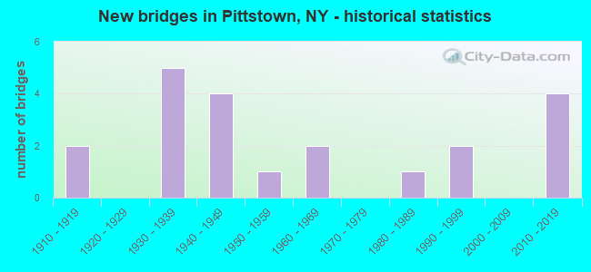
- New bridges - historical statistics
- 21910-1919
- 51930-1939
- 41940-1949
- 11950-1959
- 21960-1969
- 11980-1989
- 21990-1999
- 42010-2019
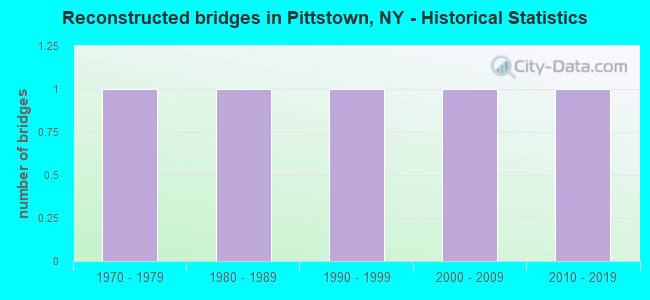
- Reconstructed bridges - Historical Statistics
- 11970-1979
- 11980-1989
- 11990-1999
- 12000-2009
- 12010-2019
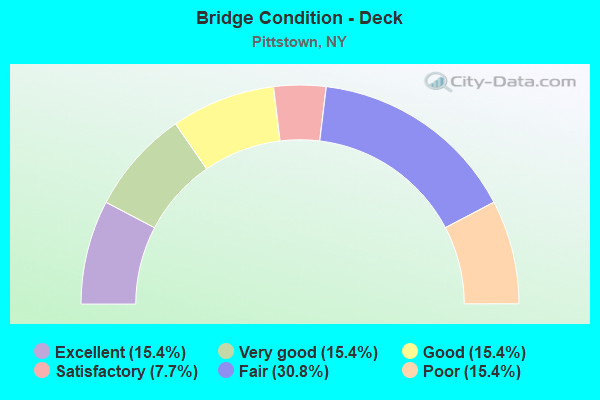
- Bridge Condition - Deck
- 15.4%Excellent
- 15.4%Very good
- 15.4%Good
- 7.7%Satisfactory
- 30.8%Fair
- 15.4%Poor
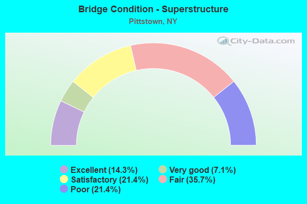
- Bridge Condition - Superstructure
- 14.3%Excellent
- 7.1%Very good
- 21.4%Satisfactory
- 35.7%Fair
- 21.4%Poor
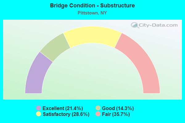
- Bridge Condition - Substructure
- 21.4%Excellent
- 14.3%Good
- 28.6%Satisfactory
- 35.7%Fair
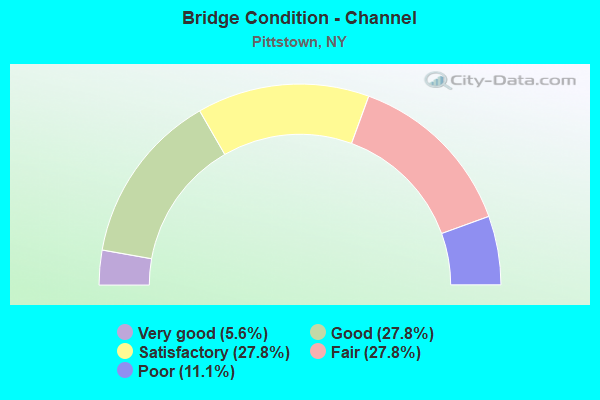
- Bridge Condition - Channel
- 5.6%Very good
- 27.8%Good
- 27.8%Satisfactory
- 27.8%Fair
- 11.1%Poor
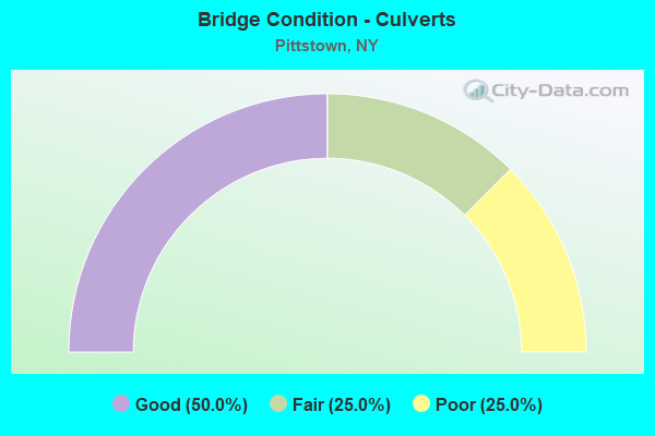
- Bridge Condition - Culverts
- 50.0%Good
- 25.0%Fair
- 25.0%Poor
Find on map >> Show street view
Structure Number: 100428, Location: 0.9 MI NE RAYMERTOWN (Lat: 42.819425, Lng: -73.520172), Route carried "on" structure: State highway 7, Year Built: 1932, Year Reconstructed: 1983, Status: Open, Structure Length: 1.13m (3.71ft), Average Daily Traffic: 8,594 (year 2020), Truck Traffic: 10%, Average Future Daily Traffic: 9,628 (year 2040), Design Load: HS 20, Features Intersected: TOMHANNOCK RES
Minimum Vertical Clearance: 30+ m (98+ ft), Kilometerpoint: 17.651, Lanes on structure: 2, Base Highway Network: Yes, Owner: State Highway Agency, Approaching Roadway Width: 11.0m (36.1ft), Material/Design: Prestressed concrete, Design/Construction: Box Beam or Girders - Multiple, Number Of Spans In Main Unit: 1, Length of Maximum Span: 10.6m (34.8ft), Curb-To-Curb Width: 11.0m (36.1ft), Out-to-Out Width: 11.6m (38.1ft)
Condition: Deck: Fair, Superstructure: Satisfactory, Substructure: Fair, Channel: Good, Operating Rating: 82.6 metric tons, Method Used To Determine Operating Rating: Load Factor (LF), Inventory Rating: 10.0 metric tons, Method Used To Determine Inventory Rating: Load Factor (LF), Structural Evaluation: High priority of corrective action, Deck Geometry: Meets minimum limits, Waterway Adequacy: Equal to present minimum criteria, Approach Roadway Alignment: Equal to present desirable criteria, Length Of Structure Improvement: 1.12m (3.67ft), Designated Inspection Frequency: Every 24 months, Underwater Inspection Frequency: Every 60 months, Inspection Date: September 2020, Underwater Inspection Date: May 2018, Bridge Improvement Cost: $944,000, Roadway Improvement Cost: $553,000, Total Project Cost: $1,496,000 ( Estimate for 2021), Deck Structure Type: Concrete Cast-file-Place, Wearing Surface/Protective System: Wearing Surface: Bituminous, Deck Protection: Other Coated Reinforcing
Find on map >> Show street view
Structure Number: 107941, Location: 75 FT W INT HALL RD (Lat: 42.846350, Lng: -73.465700), Route carried "on" structure: State highway 7, Year Built: 2016, Status: Open, Structure Length: 0.79m (2.59ft), Average Daily Traffic: 6,362 (year 2020), Truck Traffic: 13%, Average Future Daily Traffic: 7,127 (year 2040), Features Intersected: Tributary to Sunkauissia
Minimum Vertical Clearance: 30+ m (98+ ft), Kilometerpoint: 23.331, Lanes on structure: 2, Base Highway Network: Yes, Owner: State Highway Agency, Approaching Roadway Width: 13.4m (44.0ft), Skew: 3 degrees, Material/Design: Concrete, Design/Construction: Frame, Number Of Spans In Main Unit: 1, Length of Maximum Span: 7.0m (23.0ft), Curb-To-Curb Width: 13.4m (44.0ft), Out-to-Out Width: 14.7m (48.2ft)
Condition: Superstructure: Excellent, Substructure: Excellent, Channel: Good, Operating Rating: 53.5 metric tons, Method Used To Determine Operating Rating: Load Factor (LF), Inventory Rating: 31.8 metric tons, Method Used To Determine Inventory Rating: Load Factor (LF), Structural Evaluation: Better than present minimum criteria, Deck Geometry: Equal to present minimum criteria, Waterway Adequacy: Somewhat better than minimum adequacy, Approach Roadway Alignment: Equal to present desirable criteria, Length Of Structure Improvement: 0.79m (2.59ft), Designated Inspection Frequency: Every 24 months, Inspection Date: September 2020, Bridge Improvement Cost: $351,000, Roadway Improvement Cost: $206,000, Total Project Cost: $557,000 ( Estimate for 2021), Wearing Surface/Protective System: Wearing Surface: Bituminous
Find on map >> Show street view
Structure Number: 220177, Location: 1.5 MI.W.OF PITTSTOWN (Lat: 42.839625, Lng: -73.512033), Route carried "on" structure: Other road , Year Built: 1960, Status: Open, Structure Length: 2.19m (7.19ft), Average Daily Traffic: 20 (year 2018), Truck Traffic: 6%, Average Future Daily Traffic: 28 (year 2038), Features Intersected: SUNKAVISSIA CREEK, Facility Carried by Structure: HOLBRITTER ROAD
Minimum Vertical Clearance: 30+ m (98+ ft), Kilometerpoint: 0.064, Lanes on structure: 2, Owner: Town or Township Highway Agency, Approaching Roadway Width: 4.6m (15.1ft), Material/Design: Steel, Design/Construction: Stringer/Multi-beam, Number Of Spans In Main Unit: 2, Length of Maximum Span: 10.4m (34.1ft), Curb-To-Curb Width: 6.1m (20.0ft), Out-to-Out Width: 7.3m (24.0ft)
Condition: Deck: Satisfactory, Superstructure: Poor, Substructure: Satisfactory, Channel: Fair, Operating Rating: 40.5 metric tons, Method Used To Determine Operating Rating: Load and Resistance Factor Rating (LRFR) rating reported by rating factor(RF) method using HL-93 loadings, Inventory Rating: 31.4 metric tons, Method Used To Determine Inventory Rating: Load and Resistance Factor Rating (LRFR) rating reported by rating factor(RF) method using HL-93 loadings, Structural Evaluation: Meets minimum limits, Deck Geometry: Somewhat better than minimum adequacy, Waterway Adequacy: Somewhat better than minimum adequacy, Approach Roadway Alignment: Somewhat better than minimum adequacy, Length Of Structure Improvement: 2.19m (7.19ft), Designated Inspection Frequency: Every 24 months, Inspection Date: May 2020, Bridge Improvement Cost: $460,000, Roadway Improvement Cost: $269,000, Total Project Cost: $729,000 ( Estimate for 2021), Deck Structure Type: Wood or Timber, Wearing Surface/Protective System: Wearing Surface: Wood or Timber
Find on map >> Show street view
Structure Number: 220178, Location: 0.8MI.W.OF VIL.PITTSTOWN (Lat: 42.837611, Lng: -73.499839), Route carried "on" structure: Other road , Year Built: 1910, Year Reconstructed: 2016, Status: Open, Structure Length: 1.31m (4.30ft), Average Daily Traffic: 99 (year 2018), Truck Traffic: 6%, Average Future Daily Traffic: 139 (year 2038), Features Intersected: SUNKAUISSIA CRK, Facility Carried by Structure: FACTORY HOLLOW RD
Minimum Vertical Clearance: 30+ m (98+ ft), Kilometerpoint: 1.995, Lanes on structure: 1, Owner: Town or Township Highway Agency, Approaching Roadway Width: 3.0m (9.8ft), Material/Design: Steel, Design/Construction: Stringer/Multi-beam, Number Of Spans In Main Unit: 1, Length of Maximum Span: 12.8m (42.0ft), Curb-To-Curb Width: 4.0m (13.1ft), Out-to-Out Width: 4.9m (16.1ft)
Condition: Deck: Excellent, Superstructure: Fair, Substructure: Fair, Channel: Fair, Operating Rating: 59.9 metric tons, Method Used To Determine Operating Rating: Allowable Stress (AS), Inventory Rating: 40.8 metric tons, Method Used To Determine Inventory Rating: Allowable Stress (AS), Structural Evaluation: Somewhat better than minimum adequacy, Deck Geometry: Somewhat better than minimum adequacy, Waterway Adequacy: Meets minimum limits, Approach Roadway Alignment: Meets minimum limits, Length Of Structure Improvement: 1.31m (4.30ft), Designated Inspection Frequency: Every 24 months, Inspection Date: June 2020, Bridge Improvement Cost: $233,000, Roadway Improvement Cost: $136,000, Total Project Cost: $369,000 ( Estimate for 2021), Deck Structure Type: Wood or Timber, Wearing Surface/Protective System: Wearing Surface: Bituminous, Membrane: Other
Find on map >> Show street view
Structure Number: 220179, Location: 0.8 MI W RTE 7 PITTSTOWN (Lat: 42.837519, Lng: -73.500494), Route carried "on" structure: Other road , Year Built: 1910, Year Reconstructed: 2014, Status: Open, Structure Length: 1.46m (4.79ft), Average Daily Traffic: 99 (year 2018), Truck Traffic: 6%, Average Future Daily Traffic: 139 (year 2038), Features Intersected: SUNKAUISSIA CK, Facility Carried by Structure: FACTORY HOLLOW RD
Minimum Vertical Clearance: 30+ m (98+ ft), Kilometerpoint: 1.979, Lanes on structure: 1, Owner: Town or Township Highway Agency, Approaching Roadway Width: 4.3m (14.1ft), Material/Design: Steel, Design/Construction: Stringer/Multi-beam, Number Of Spans In Main Unit: 1, Length of Maximum Span: 14.0m (45.9ft), Curb-To-Curb Width: 4.2m (13.8ft), Out-to-Out Width: 4.9m (16.1ft)
Condition: Deck: Very good, Superstructure: Satisfactory, Substructure: Fair, Channel: Satisfactory, Operating Rating: 43.4 metric tons, Method Used To Determine Operating Rating: Load and Resistance Factor Rating (LRFR) rating reported by rating factor(RF) method using HL-93 loadings, Inventory Rating: 33.4 metric tons, Method Used To Determine Inventory Rating: Load and Resistance Factor Rating (LRFR) rating reported by rating factor(RF) method using HL-93 loadings, Structural Evaluation: Somewhat better than minimum adequacy, Deck Geometry: Somewhat better than minimum adequacy, Waterway Adequacy: Meets minimum limits, Approach Roadway Alignment: Meets minimum limits, Length Of Structure Improvement: 1.46m (4.79ft), Designated Inspection Frequency: Every 24 months, Inspection Date: August 2020, Bridge Improvement Cost: $182,000, Roadway Improvement Cost: $106,000, Total Project Cost: $288,000 ( Estimate for 2021), Deck Structure Type: Wood or Timber, Wearing Surface/Protective System: Wearing Surface: Bituminous
Find on map >> Show street view
Structure Number: 220184, Location: 1.8 MI SE OF BOYNTONVILLE (Lat: 42.823500, Lng: -73.439211), Route carried "on" structure: Other road , Year Built: 1950, Year Reconstructed: 1998, Status: Open, Structure Length: 1.16m (3.81ft), Average Daily Traffic: 97 (year 2017), Truck Traffic: 6%, Average Future Daily Traffic: 136 (year 2037), Features Intersected: COUCH HOLLOW, Facility Carried by Structure: KAUTZ HOLLOW RD
Minimum Vertical Clearance: 30+ m (98+ ft), Kilometerpoint: 0.837, Lanes on structure: 2, Owner: Town or Township Highway Agency, Approaching Roadway Width: 5.2m (17.1ft), Skew: 3 degrees, Material/Design: Steel, Design/Construction: Stringer/Multi-beam, Number Of Spans In Main Unit: 1, Length of Maximum Span: 10.7m (35.1ft), Curb-To-Curb Width: 5.3m (17.4ft), Out-to-Out Width: 6.2m (20.3ft)
Condition: Deck: Poor, Superstructure: Poor, Substructure: Satisfactory, Channel: Fair, Operating Rating: 31.4 metric tons, Method Used To Determine Operating Rating: Load and Resistance Factor Rating (LRFR) rating reported by rating factor(RF) method using HL-93 loadings, Inventory Rating: 24.3 metric tons, Method Used To Determine Inventory Rating: Load and Resistance Factor Rating (LRFR) rating reported by rating factor(RF) method using HL-93 loadings, Structural Evaluation: Meets minimum limits, Deck Geometry: High priority of corrective action, Waterway Adequacy: Meets minimum limits, Approach Roadway Alignment: Meets minimum limits, Length Of Structure Improvement: 1.15m (3.77ft), Designated Inspection Frequency: Every 12 months, Inspection Date: May 2021, Bridge Improvement Cost: $295,000, Roadway Improvement Cost: $173,000, Total Project Cost: $468,000 ( Estimate for 2021), Deck Structure Type: Wood or Timber, Wearing Surface/Protective System: Wearing Surface: Wood or Timber
Find on map >> Show street view
Structure Number: 220185, Location: 0.1 MI E OF RAYMERTOWN (Lat: 42.813194, Lng: -73.533681), Route carried "on" structure: County highway , Year Built: 1991, Status: Open, Structure Length: 1.52m (4.99ft), Average Daily Traffic: 446 (year 2018), Truck Traffic: 4%, Average Future Daily Traffic: 624 (year 2038), Design Load: HS 20, Features Intersected: TOMHANNOCK CREEK, Facility Carried by Structure: LOG WOODS ROAD
Minimum Vertical Clearance: 30+ m (98+ ft), Kilometerpoint: 0.097, Lanes on structure: 2, Owner: Town or Township Highway Agency, Approaching Roadway Width: 7.3m (24.0ft), Material/Design: Steel, Design/Construction: Culvert, Number Of Spans In Main Unit: 1, Length of Maximum Span: 14.9m (48.9ft)
Condition: Channel: Good, Culverts: Good, Operating Rating: 83.2 metric tons, Method Used To Determine Operating Rating: Field evaluation and documented engineering judgment, Inventory Rating: 32.7 metric tons, Method Used To Determine Inventory Rating: Field evaluation and documented engineering judgment, Structural Evaluation: Better than present minimum criteria, Waterway Adequacy: Somewhat better than minimum adequacy, Approach Roadway Alignment: Equal to present desirable criteria, Length Of Structure Improvement: 1.52m (4.99ft), Designated Inspection Frequency: Every 24 months, Inspection Date: July 2021, Bridge Improvement Cost: $213,000, Roadway Improvement Cost: $125,000, Total Project Cost: $337,000 ( Estimate for 2021)
Find on map >> Show street view
Structure Number: 226898, Location: .2M FROM INTER OF HUNT RD (Lat: 42.930100, Lng: -73.466017), Route carried "on" structure: Other road , Year Built: 1998, Status: Open, Structure Length: 0.91m (2.99ft), Average Daily Traffic: 15 (year 2019), Truck Traffic: 6%, Average Future Daily Traffic: 21 (year 2039), Design Load: HS 25 or greater, Features Intersected: NIPMOOSE BROOK, Facility Carried by Structure: GOOSEN-REGAN ROAD
Minimum Vertical Clearance: 30+ m (98+ ft), Kilometerpoint: 3.813, Lanes on structure: 2, Owner: County Highway Agency, Approaching Roadway Width: 5.8m (19.0ft), Material/Design: Steel, Design/Construction: Stringer/Multi-beam, Number Of Spans In Main Unit: 1, Length of Maximum Span: 8.5m (27.9ft), Curb-To-Curb Width: 5.6m (18.4ft), Out-to-Out Width: 6.4m (21.0ft)
Condition: Deck: Fair, Superstructure: Poor, Substructure: Good, Channel: Good, Operating Rating: 64.2 metric tons, Method Used To Determine Operating Rating: Load and Resistance Factor Rating (LRFR) rating reported by rating factor(RF) method using HL-93 loadings, Inventory Rating: 49.6 metric tons, Method Used To Determine Inventory Rating: Load and Resistance Factor Rating (LRFR) rating reported by rating factor(RF) method using HL-93 loadings, Structural Evaluation: Meets minimum limits, Deck Geometry: Meets minimum limits, Waterway Adequacy: Equal to present minimum criteria, Approach Roadway Alignment: Better than present minimum criteria, Length Of Structure Improvement: 0.91m (2.99ft), Designated Inspection Frequency: Every 24 months, Inspection Date: September 2020, Bridge Improvement Cost: $201,000, Roadway Improvement Cost: $118,000, Total Project Cost: $319,000 ( Estimate for 2021), Deck Structure Type: Wood or Timber, Wearing Surface/Protective System: Wearing Surface: Wood or Timber
Find on map >> Show street view
Structure Number: 227096, Location: Appr. 110' from Rt. 7 (Lat: 42.846869, Lng: -73.465711), Route carried "on" structure: Other road , Year Built: 2013, Status: Open, Structure Length: 0.64m (2.10ft), Features Intersected: Tributary to Sunkauissia, Facility Carried by Structure: Hall Road
Minimum Vertical Clearance: 30+ m (98+ ft), Kilometerpoint: 1.593, Lanes on structure: 2, Owner: Town or Township Highway Agency, Approaching Roadway Width: 7.3m (24.0ft), Skew: 3 degrees, Material/Design: Concrete, Design/Construction: Culvert, Number Of Spans In Main Unit: 2, Length of Maximum Span: 3.0m (9.8ft)
Condition: Channel: Poor, Culverts: Good, Operating Rating: 74.8 metric tons, Method Used To Determine Operating Rating: Field evaluation and documented engineering judgment, Inventory Rating: 40.8 metric tons, Method Used To Determine Inventory Rating: Field evaluation and documented engineering judgment, Structural Evaluation: Better than present minimum criteria, Waterway Adequacy: Meets minimum limits, Approach Roadway Alignment: Equal to present desirable criteria, Length Of Structure Improvement: 0.64m (2.10ft), Designated Inspection Frequency: Every 24 months, Inspection Date: September 2020, Bridge Improvement Cost: $83,000, Roadway Improvement Cost: $48,000, Total Project Cost: $131,000 ( Estimate for 2021)
Find on map >> Show street view
Structure Number: 330334, Location: IN JOHNSONVILLE (Lat: 42.918003, Lng: -73.514256), Route carried "on" structure: County highway , Year Built: 2016, Status: Open, Structure Length: 6.19m (20.31ft), Average Daily Traffic: 358 (year 2017), Truck Traffic: 6%, Average Future Daily Traffic: 501 (year 2037), Design Load: HL 93, Features Intersected: HOOSIC RIVER, Facility Carried by Structure: COUNTY ROAD 111
Minimum Vertical Clearance: 5.15m (16.90ft), Kilometerpoint: 0.370, Lanes on structure: 2, Owner: County Highway Agency, Approaching Roadway Width: 9.1m (29.9ft), Material/Design: Steel continuous, Design/Construction: Stringer/Multi-beam, Number Of Spans In Main Unit: 2, Length of Maximum Span: 30.2m (99.1ft), Curb-To-Curb Width: 9.1m (29.9ft), Out-to-Out Width: 10.1m (33.1ft)
Condition: Deck: Very good, Superstructure: Excellent, Substructure: Excellent, Channel: Satisfactory, Operating Rating: 42.1 metric tons, Method Used To Determine Operating Rating: Load and Resistance Factor Rating (LRFR) rating reported by rating factor(RF) method using HL-93 loadings, Inventory Rating: 32.4 metric tons, Method Used To Determine Inventory Rating: Load and Resistance Factor Rating (LRFR) rating reported by rating factor(RF) method using HL-93 loadings, Structural Evaluation: Equal to present desirable criteria, Deck Geometry: Equal to present minimum criteria, Waterway Adequacy: Somewhat better than minimum adequacy, Approach Roadway Alignment: Equal to present desirable criteria, Length Of Structure Improvement: 6.18m (20.28ft), Designated Inspection Frequency: Every 24 months, Inspection Date: September 2020, Bridge Improvement Cost: $1,766,000, Roadway Improvement Cost: $1,034,000, Total Project Cost: $2,799,000 ( Estimate for 2021), Deck Structure Type: Concrete Cast-file-Place, Wearing Surface/Protective System: Wearing Surface: Integral Concrete, Deck Protection: Epoxy Coated Reinforcing
Find on map >> Show street view
Structure Number: 330337, Location: 0.5MI N OF PITTSTOWN (Lat: 42.840119, Lng: -73.486339), Route carried "on" structure: County highway , Year Built: 1947, Status: Open, Structure Length: 1.52m (4.99ft), Average Daily Traffic: 479 (year 2017), Truck Traffic: 7%, Average Future Daily Traffic: 671 (year 2037), Features Intersected: SUNKAUISSIA CK, Facility Carried by Structure: COUNTY RD 111
Minimum Vertical Clearance: 30+ m (98+ ft), Kilometerpoint: 0.644, Lanes on structure: 2, Owner: County Highway Agency, Approaching Roadway Width: 5.5m (18.0ft), Material/Design: Steel, Design/Construction: Stringer/Multi-beam, Number Of Spans In Main Unit: 1, Length of Maximum Span: 14.0m (45.9ft), Curb-To-Curb Width: 6.9m (22.6ft), Out-to-Out Width: 7.3m (24.0ft)
Condition: Deck: Fair, Superstructure: Fair, Substructure: Satisfactory, Channel: Fair, Operating Rating: 57.7 metric tons, Method Used To Determine Operating Rating: Load and Resistance Factor Rating (LRFR) rating reported by rating factor(RF) method using HL-93 loadings, Inventory Rating: 44.4 metric tons, Method Used To Determine Inventory Rating: Load and Resistance Factor Rating (LRFR) rating reported by rating factor(RF) method using HL-93 loadings, Structural Evaluation: Somewhat better than minimum adequacy, Deck Geometry: Meets minimum limits, Waterway Adequacy: Meets minimum limits, Approach Roadway Alignment: Better than present minimum criteria, Length Of Structure Improvement: 1.52m (4.99ft), Designated Inspection Frequency: Every 24 months, Inspection Date: June 2020, Bridge Improvement Cost: $380,000, Roadway Improvement Cost: $222,000, Total Project Cost: $602,000 ( Estimate for 2021), Deck Structure Type: Concrete Cast-file-Place, Wearing Surface/Protective System: Wearing Surface: Bituminous
Find on map >> Show street view
Structure Number: 330341, Location: 4.4 MI NW PITTSTOWN (Lat: 42.868853, Lng: -73.556367), Route carried "on" structure: County highway , Year Built: 1948, Status: Open, Structure Length: 1.01m (3.31ft), Average Daily Traffic: 1,527 (year 2017), Truck Traffic: 5%, Average Future Daily Traffic: 2,138 (year 2037), Design Load: H 20, Features Intersected: TOMHANNOCKBACKWTR, Facility Carried by Structure: COUNTY RD 115
Minimum Vertical Clearance: 30+ m (98+ ft), Kilometerpoint: 7.047, Lanes on structure: 2, Owner: County Highway Agency, Approaching Roadway Width: 6.1m (20.0ft), Material/Design: Concrete, Design/Construction: Slab, Number Of Spans In Main Unit: 1, Length of Maximum Span: 9.1m (29.9ft), Curb-To-Curb Width: 8.5m (27.9ft), Out-to-Out Width: 9.6m (31.5ft)
Condition: Deck: Fair, Superstructure: Fair, Substructure: Satisfactory, Channel: Satisfactory, Operating Rating: 59.6 metric tons, Method Used To Determine Operating Rating: Load and Resistance Factor Rating (LRFR) rating reported by rating factor(RF) method using HL-93 loadings, Inventory Rating: 46.0 metric tons, Method Used To Determine Inventory Rating: Load and Resistance Factor Rating (LRFR) rating reported by rating factor(RF) method using HL-93 loadings, Structural Evaluation: Somewhat better than minimum adequacy, Deck Geometry: Somewhat better than minimum adequacy, Waterway Adequacy: Somewhat better than minimum adequacy, Approach Roadway Alignment: Better than present minimum criteria, Length Of Structure Improvement: 1.00m (3.28ft), Designated Inspection Frequency: Every 24 months, Inspection Date: June 2020, Bridge Improvement Cost: $576,000, Roadway Improvement Cost: $338,000, Total Project Cost: $914,000 ( Estimate for 2021), Wearing Surface/Protective System: Wearing Surface: Bituminous
Find on map >> Show street view
Structure Number: 330342, Location: 2.1 MI W PITTSTOWN (Lat: 42.838814, Lng: -73.524664), Route carried "on" structure: County highway , Year Built: 1949, Status: Open, Structure Length: 2.32m (7.61ft), Average Daily Traffic: 997 (year 2016), Truck Traffic: 5%, Average Future Daily Traffic: 1,396 (year 2036), Design Load: H 20, Features Intersected: TOMHANNOCK BACKWR, Facility Carried by Structure: COUNTY RD 115
Minimum Vertical Clearance: 30+ m (98+ ft), Kilometerpoint: 2.301, Lanes on structure: 2, Owner: County Highway Agency, Approaching Roadway Width: 7.3m (24.0ft), Material/Design: Steel, Design/Construction: Stringer/Multi-beam, Number Of Spans In Main Unit: 1, Length of Maximum Span: 21.9m (71.9ft), Curb or Sidewalk Widths: Left: 0.9m (3.0ft), Right: 0.9m (3.0ft), Curb-To-Curb Width: 7.3m (24.0ft), Out-to-Out Width: 9.4m (30.8ft)
Condition: Deck: Poor, Superstructure: Satisfactory, Substructure: Fair, Channel: Very good, Operating Rating: 42.4 metric tons, Method Used To Determine Operating Rating: Load and Resistance Factor Rating (LRFR) rating reported by rating factor(RF) method using HL-93 loadings, Inventory Rating: 32.4 metric tons, Method Used To Determine Inventory Rating: Load and Resistance Factor Rating (LRFR) rating reported by rating factor(RF) method using HL-93 loadings, Structural Evaluation: Somewhat better than minimum adequacy, Deck Geometry: Meets minimum limits, Waterway Adequacy: Somewhat better than minimum adequacy, Approach Roadway Alignment: Equal to present minimum criteria, Length Of Structure Improvement: 2.31m (7.58ft), Designated Inspection Frequency: Every 24 months, Inspection Date: July 2020, Bridge Improvement Cost: $548,000, Roadway Improvement Cost: $321,000, Total Project Cost: $869,000 ( Estimate for 2021), Deck Structure Type: Concrete Cast-file-Place, Wearing Surface/Protective System: Wearing Surface: Bituminous
Find on map >> Show street view
Structure Number: 330343, Location: 2.5 MI SSE VALLEY FALLS (Lat: 42.869156, Lng: -73.543344), Route carried "on" structure: County highway , Year Built: 1945, Status: Open, Structure Length: 0.98m (3.22ft), Average Daily Traffic: 753 (year 2016), Truck Traffic: 5%, Average Future Daily Traffic: 1,054 (year 2036), Features Intersected: OTTER CREEK, Facility Carried by Structure: COUNTY ROAD 110
Minimum Vertical Clearance: 32.69m (107.25ft), Kilometerpoint: 1.110, Lanes on structure: 2, Owner: County Highway Agency, Approaching Roadway Width: 6.1m (20.0ft), Skew: 1 degrees, Material/Design: Steel, Design/Construction: Stringer/Multi-beam, Number Of Spans In Main Unit: 1, Length of Maximum Span: 8.8m (28.9ft), Curb-To-Curb Width: 6.1m (20.0ft), Out-to-Out Width: 6.5m (21.3ft)
Condition: Deck: Good, Superstructure: Fair, Substructure: Good, Channel: Fair, Operating Rating: 43.7 metric tons, Method Used To Determine Operating Rating: Load and Resistance Factor Rating (LRFR) rating reported by rating factor(RF) method using HL-93 loadings, Inventory Rating: 33.7 metric tons, Method Used To Determine Inventory Rating: Load and Resistance Factor Rating (LRFR) rating reported by rating factor(RF) method using HL-93 loadings, Structural Evaluation: Somewhat better than minimum adequacy, Deck Geometry: High priority of corrective action, Waterway Adequacy: Equal to present desirable criteria, Approach Roadway Alignment: Meets minimum limits, Length Of Structure Improvement: 0.97m (3.18ft), Designated Inspection Frequency: Every 24 months, Inspection Date: April 2020, Bridge Improvement Cost: $274,000, Roadway Improvement Cost: $161,000, Total Project Cost: $435,000 ( Estimate for 2021), Deck Structure Type: Concrete Cast-file-Place, Wearing Surface/Protective System: Wearing Surface: Bituminous
Find on map >> Show street view
Structure Number: 330344, Location: 0.3 MI.N.OF BOYNTONVILLE (Lat: 42.850008, Lng: -73.455572), Route carried "on" structure: County highway , Year Built: 1938, Status: Open, Structure Length: 1.28m (4.20ft), Average Daily Traffic: 493 (year 2016), Truck Traffic: 7%, Average Future Daily Traffic: 690 (year 2036), Features Intersected: SUNKAUISSIA CK, Facility Carried by Structure: GROVESIDE CR.109
Minimum Vertical Clearance: 30+ m (98+ ft), Kilometerpoint: 0.740, Lanes on structure: 2, Owner: County Highway Agency, Approaching Roadway Width: 7.6m (24.9ft), Material/Design: Steel, Design/Construction: Culvert, Number Of Spans In Main Unit: 2, Length of Maximum Span: 6.0m (19.7ft), Curb-To-Curb Width: 7.5m (24.6ft), Out-to-Out Width: 8.5m (27.9ft)
Condition: Channel: Satisfactory, Culverts: Fair, Operating Rating: 72.5 metric tons, Method Used To Determine Operating Rating: Field evaluation and documented engineering judgment, Inventory Rating: 19.6 metric tons, Method Used To Determine Inventory Rating: Field evaluation and documented engineering judgment, Structural Evaluation: Somewhat better than minimum adequacy, Deck Geometry: Meets minimum limits, Waterway Adequacy: Equal to present desirable criteria, Approach Roadway Alignment: Better than present minimum criteria, Length Of Structure Improvement: 1.28m (4.20ft), Designated Inspection Frequency: Every 24 months, Inspection Date: April 2020, Bridge Improvement Cost: $193,000, Roadway Improvement Cost: $113,000, Total Project Cost: $305,000 ( Estimate for 2021), Wearing Surface/Protective System: Wearing Surface: Bituminous
Find on map >> Show street view
Structure Number: 330345, Location: 3.1 MI N.OF PITTSTOWN (Lat: 42.879219, Lng: -73.498717), Route carried "on" structure: County highway , Year Built: 1965, Year Reconstructed: 1994, Status: Open, Structure Length: 1.04m (3.41ft), Average Daily Traffic: 479 (year 2017), Truck Traffic: 7%, Average Future Daily Traffic: 671 (year 2037), Features Intersected: OTTER CREEK, Facility Carried by Structure: COUNTY ROAD 111
Minimum Vertical Clearance: 30+ m (98+ ft), Kilometerpoint: 6.098, Lanes on structure: 2, Owner: County Highway Agency, Approaching Roadway Width: 6.4m (21.0ft), Material/Design: Steel, Design/Construction: Stringer/Multi-beam, Number Of Spans In Main Unit: 1, Length of Maximum Span: 10.1m (33.1ft), Curb-To-Curb Width: 6.5m (21.3ft), Out-to-Out Width: 7.0m (23.0ft)
Condition: Deck: Good, Superstructure: Fair, Substructure: Fair, Channel: Poor, Operating Rating: 43.1 metric tons, Method Used To Determine Operating Rating: Load and Resistance Factor Rating (LRFR) rating reported by rating factor(RF) method using HL-93 loadings, Inventory Rating: 33.4 metric tons, Method Used To Determine Inventory Rating: Load and Resistance Factor Rating (LRFR) rating reported by rating factor(RF) method using HL-93 loadings, Structural Evaluation: Somewhat better than minimum adequacy, Deck Geometry: High priority of corrective action, Waterway Adequacy: Equal to present desirable criteria, Approach Roadway Alignment: Equal to present minimum criteria, Length Of Structure Improvement: 1.03m (3.38ft), Designated Inspection Frequency: Every 24 months, Inspection Date: April 2020, Bridge Improvement Cost: $212,000, Roadway Improvement Cost: $124,000, Total Project Cost: $336,000 ( Estimate for 2021), Deck Structure Type: Concrete Cast-file-Place, Wearing Surface/Protective System: Wearing Surface: Bituminous, Membrane: Other
Find on map >> Show street view
Structure Number: 33035, Location: 1.5 NE SPEIGLETOWN (Lat: 42.812544, Lng: -73.605803), Route carried "on" structure: County highway , Year Built: 1989, Status: Open, Structure Length: 0.67m (2.20ft), Average Daily Traffic: 571 (year 2017), Truck Traffic: 7%, Average Future Daily Traffic: 799 (year 2037), Features Intersected: DEEP KILL, Facility Carried by Structure: County Road 126
Minimum Vertical Clearance: 30+ m (98+ ft), Kilometerpoint: 2.623, Lanes on structure: 2, Owner: County Highway Agency, Approaching Roadway Width: 8.5m (27.9ft), Material/Design: Steel, Design/Construction: Culvert, Number Of Spans In Main Unit: 1, Length of Maximum Span: 6.4m (21.0ft)
Condition: Channel: Satisfactory, Culverts: Poor, Operating Rating: 75.3 metric tons, Method Used To Determine Operating Rating: Field evaluation and documented engineering judgment, Inventory Rating: 19.6 metric tons, Method Used To Determine Inventory Rating: Field evaluation and documented engineering judgment, Structural Evaluation: Meets minimum limits, Waterway Adequacy: Somewhat better than minimum adequacy, Approach Roadway Alignment: Better than present minimum criteria, Length Of Structure Improvement: 0.67m (2.20ft), Designated Inspection Frequency: Every 24 months, Inspection Date: August 2020, Bridge Improvement Cost: $101,000, Roadway Improvement Cost: $59,000, Total Project Cost: $160,000 ( Estimate for 2021), Wearing Surface/Protective System: Wearing Surface: Bituminous
Find on map >> Show street view
Structure Number: 330351, Location: 1.7 MI NE OF SPEIGLETOWN (Lat: 42.805172, Lng: -73.593711), Route carried "on" structure: County highway , Year Built: 2018, Status: Open, Structure Length: 1.40m (4.59ft), Average Daily Traffic: 745 (year 2017), Truck Traffic: 5%, Average Future Daily Traffic: 1,043 (year 2037), Features Intersected: DEEP KILL, Facility Carried by Structure: PLANK ROAD
Minimum Vertical Clearance: 30+ m (98+ ft), Kilometerpoint: 5.358, Lanes on structure: 2, Owner: County Highway Agency, Approaching Roadway Width: 7.9m (25.9ft), Skew: 1 degrees, Material/Design: Prestressed concrete, Design/Construction: Box Beam or Girders - Multiple, Number Of Spans In Main Unit: 1, Length of Maximum Span: 13.1m (43.0ft), Curb-To-Curb Width: 7.9m (25.9ft), Out-to-Out Width: 9.0m (29.5ft)
Condition: Deck: Excellent, Superstructure: Very good, Substructure: Excellent, Channel: Good, Inventory Rating: 79.8 metric tons, Method Used To Determine Inventory Rating: Load Factor (LF), Structural Evaluation: Equal to present desirable criteria, Deck Geometry: Somewhat better than minimum adequacy, Waterway Adequacy: Meets minimum limits, Approach Roadway Alignment: Equal to present desirable criteria, Length Of Structure Improvement: 1.40m (4.59ft), Designated Inspection Frequency: Every 24 months, Inspection Date: July 2020, Bridge Improvement Cost: $405,000, Roadway Improvement Cost: $237,000, Total Project Cost: $641,000 ( Estimate for 2021), Deck Structure Type: Concrete Cast-file-Place, Wearing Surface/Protective System: Wearing Surface: Integral Concrete, Deck Protection: Epoxy Coated Reinforcing
Find on map >> Show street view
Structure Number: 702924, Location: 1.5 MI E JOHNSONVILLE (Lat: 42.926108, Lng: -73.490111), Route carried "under" structure: State highway 67, Year Built: 1930, Structure Length: 0. m, Average Daily Traffic: 14,266 (year 1999), Features Intersected: RTE 67, Facility Carried by Structure: SPRINGFIELD TERML
Minimum Vertical Clearance: 4.50m (14.76ft), Kilometerpoint: 16.541, Lanes under structure: 2, Material/Design: Steel, Design/Construction: Stringer/Multi-beam, Length of Maximum Span: 17.6m (57.7ft)
Find on map >> Show street view
Structure Number: 7303471, Location: VILLAGE OF JOHNSONVILLE (Lat: 42.915542, Lng: -73.513900), Route carried "under" structure: County highway , Year Built: 1930, Structure Length: 0. m, Average Daily Traffic: 179 (year 2017), Truck Traffic: 6%, Features Intersected: COUNTY ROAD 111, Facility Carried by Structure: SPRNG TRM SERV RD
Minimum Vertical Clearance: 4.11m (13.48ft), Kilometerpoint: 0.097, Lanes under structure: 2, Material/Design: Steel, Design/Construction: Girder and Floorbeam System, Length of Maximum Span: 11.8m (38.7ft)
Find on map >> Show street view
Structure Number: 7303472, Location: VILLAGE OF JOHNSONVILLE (Lat: 42.915508, Lng: -73.513889), Route carried "under" structure: County highway , Year Built: 1930, Structure Length: 0. m, Average Daily Traffic: 179 (year 2017), Truck Traffic: 6%, Features Intersected: COUNTY ROAD 111, Facility Carried by Structure: SPRINGFIELD TERMN
Minimum Vertical Clearance: 4.11m (13.48ft), Kilometerpoint: 0.080, Lanes under structure: 2, Material/Design: Steel, Design/Construction: Girder and Floorbeam System, Length of Maximum Span: 11.8m (38.7ft)