Bridge Statistics for Porter, New York (NY)
Condition, Traffic, Stress, Structural Evaluation, Project Costs
- National Bridge Inventory (NBI) Statistics
- 36Number of bridges
- 213ft / 64.8mTotal length
- $53,373,000Total costs
- 30,663Total average daily traffic
- 1,411Total average daily truck traffic
- National Bridge Inventory (NBI) Registered Bridges for Porter
- No street view available for this location
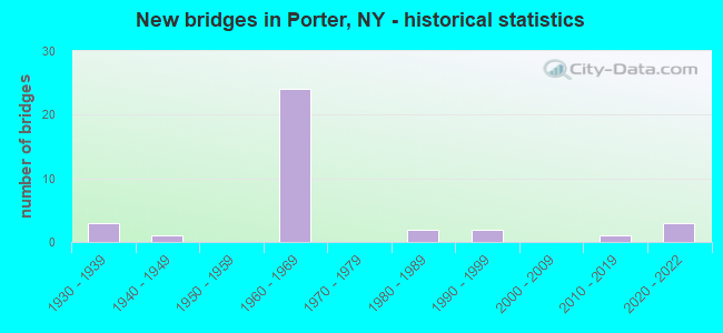
- New bridges - historical statistics
- 31930-1939
- 11940-1949
- 241960-1969
- 21980-1989
- 21990-1999
- 12010-2019
- 32020-2022
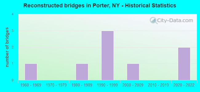
- Reconstructed bridges - Historical Statistics
- 11960-1969
- 01970-1979
- 11980-1989
- 31990-1999
- 12000-2009
- 02010-2019
- 22020-2022
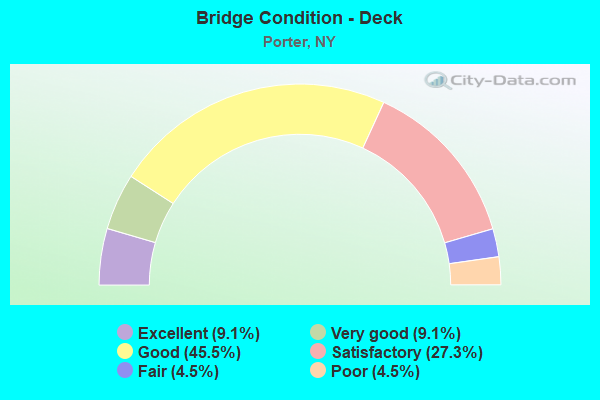
- Bridge Condition - Deck
- 9.1%Excellent
- 9.1%Very good
- 45.5%Good
- 27.3%Satisfactory
- 4.5%Fair
- 4.5%Poor
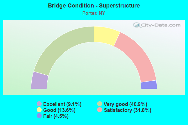
- Bridge Condition - Superstructure
- 9.1%Excellent
- 40.9%Very good
- 13.6%Good
- 31.8%Satisfactory
- 4.5%Fair
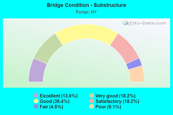
- Bridge Condition - Substructure
- 13.6%Excellent
- 18.2%Very good
- 36.4%Good
- 18.2%Satisfactory
- 4.5%Fair
- 9.1%Poor
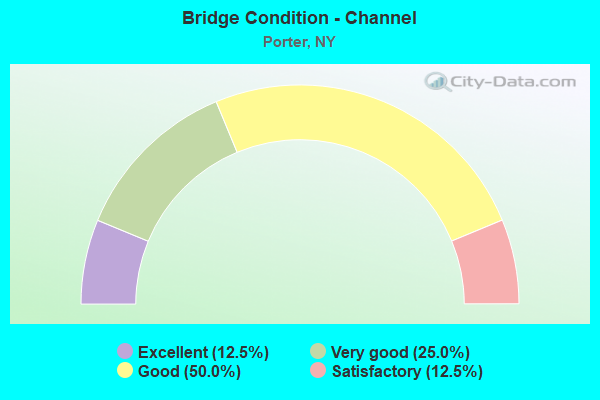
- Bridge Condition - Channel
- 12.5%Excellent
- 25.0%Very good
- 50.0%Good
- 12.5%Satisfactory
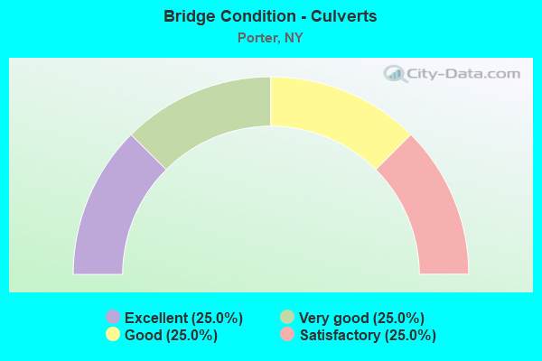
- Bridge Condition - Culverts
- 25.0%Excellent
- 25.0%Very good
- 25.0%Good
- 25.0%Satisfactory
Find on map >> Show street view
Structure Number: 101462, Location: 3.8 MI N JCT RTS 18 & 104 (Lat: 43.228928, Lng: -79.017644), Route carried "on" structure: State highway 18, Year Built: 1965, Status: Open, Structure Length: 0.70m (2.30ft), Average Daily Traffic: 2,412 (year 2019), Truck Traffic: 7%, Average Future Daily Traffic: 2,547 (year 2040), Design Load: HS 20+Mod, Features Intersected: FOUR MILE CREEK
Minimum Vertical Clearance: 30+ m (98+ ft), Kilometerpoint: 7.932, Lanes on structure: 2, Base Highway Network: Yes, Owner: State Highway Agency, Approaching Roadway Width: 12.2m (40.0ft), Material/Design: Concrete, Design/Construction: Culvert, Number Of Spans In Main Unit: 1, Length of Maximum Span: 6.7m (22.0ft), Curb-To-Curb Width: 13.4m (44.0ft), Out-to-Out Width: 14.3m (46.9ft)
Condition: Channel: Good, Culverts: Good, Operating Rating: 77.3 metric tons, Method Used To Determine Operating Rating: Field evaluation and documented engineering judgment, Inventory Rating: 32.7 metric tons, Method Used To Determine Inventory Rating: Field evaluation and documented engineering judgment, Structural Evaluation: Better than present minimum criteria, Deck Geometry: Better than present minimum criteria, Waterway Adequacy: Somewhat better than minimum adequacy, Approach Roadway Alignment: Equal to present desirable criteria, Length Of Structure Improvement: 0.70m (2.30ft), Designated Inspection Frequency: Every 24 months, Inspection Date: April 2021, Bridge Improvement Cost: $277,000, Roadway Improvement Cost: $162,000, Total Project Cost: $440,000 ( Estimate for 2021), Wearing Surface/Protective System: Wearing Surface: Bituminous, Membrane: Other
Find on map >> Show street view
Structure Number: 101463, Location: 0.8 MI N JCT RTS 18 + 93 (Lat: 43.268158, Lng: -79.004061), Route carried "on" structure: State highway 18, Year Built: 1967, Status: Open, Structure Length: 2.77m (9.09ft), Average Daily Traffic: 897 (year 2020), Truck Traffic: 7%, Average Future Daily Traffic: 946 (year 2040), Features Intersected: FOUR MILE CREEK
Minimum Vertical Clearance: 30+ m (98+ ft), Kilometerpoint: 12.631, Lanes on structure: 2, Base Highway Network: Yes, Owner: State Highway Agency, Approaching Roadway Width: 13.7m (44.9ft), Material/Design: Steel, Design/Construction: Stringer/Multi-beam, Number Of Spans In Main Unit: 1, Length of Maximum Span: 26.2m (86.0ft), Curb or Sidewalk Widths: Left: 0.6m (2.0ft), Right: 0.6m (2.0ft), Curb-To-Curb Width: 8.5m (27.9ft), Out-to-Out Width: 10.2m (33.5ft)
Condition: Deck: Satisfactory, Superstructure: Good, Substructure: Fair, Channel: Very good, Operating Rating: 87.1 metric tons, Method Used To Determine Operating Rating: Load Factor (LF), Inventory Rating: 51.7 metric tons, Method Used To Determine Inventory Rating: Load Factor (LF), Structural Evaluation: Somewhat better than minimum adequacy, Deck Geometry: Somewhat better than minimum adequacy, Waterway Adequacy: Equal to present minimum criteria, Approach Roadway Alignment: Equal to present desirable criteria, Length Of Structure Improvement: 2.77m (9.09ft), Designated Inspection Frequency: Every 24 months, Inspection Date: April 2021, Bridge Improvement Cost: $1,295,000, Roadway Improvement Cost: $759,000, Total Project Cost: $2,054,000 ( Estimate for 2021), Deck Structure Type: Concrete Cast-file-Place, Wearing Surface/Protective System: Wearing Surface: Integral Concrete
Find on map >> Show street view
Structure Number: 101464, Location: 2.7 MI E JCT RTS 18 + 18F (Lat: 43.283461, Lng: -78.956019), Route carried "on" structure: State highway 18, Year Built: 1989, Status: Open, Structure Length: 1.65m (5.41ft), Average Daily Traffic: 1,526 (year 2017), Truck Traffic: 5%, Average Future Daily Traffic: 1,609 (year 2040), Design Load: HS 20, Features Intersected: SIX MILE CREEK
Minimum Vertical Clearance: 30+ m (98+ ft), Kilometerpoint: 16.927, Lanes on structure: 2, Base Highway Network: Yes, Owner: State Highway Agency, Approaching Roadway Width: 12.2m (40.0ft), Material/Design: Prestressed concrete, Design/Construction: Box Beam or Girders - Multiple, Number Of Spans In Main Unit: 1, Length of Maximum Span: 16.1m (52.8ft), Curb-To-Curb Width: 12.2m (40.0ft), Out-to-Out Width: 13.6m (44.6ft)
Condition: Deck: Very good, Superstructure: Very good, Substructure: Good, Channel: Very good, Operating Rating: 71.3 metric tons, Method Used To Determine Operating Rating: Load and Resistance Factor Rating (LRFR) rating reported by rating factor(RF) method using HL-93 loadings, Inventory Rating: 45.0 metric tons, Method Used To Determine Inventory Rating: Load and Resistance Factor Rating (LRFR) rating reported by rating factor(RF) method using HL-93 loadings, Structural Evaluation: Better than present minimum criteria, Deck Geometry: Better than present minimum criteria, Waterway Adequacy: Somewhat better than minimum adequacy, Approach Roadway Alignment: Equal to present desirable criteria, Length Of Structure Improvement: 1.64m (5.38ft), Designated Inspection Frequency: Every 24 months, Inspection Date: October 2021, Bridge Improvement Cost: $858,000, Roadway Improvement Cost: $502,000, Total Project Cost: $1,360,000 ( Estimate for 2021), Wearing Surface/Protective System: Wearing Surface: Monolithic Concrete
Find on map >> Show street view
Structure Number: 1014871, Location: JCT RT 18F & NIAGARA PKWY (Lat: 43.264647, Lng: -79.046122), Route carried "on" structure: Other road 957A, Year Built: 1967, Year Reconstructed: 1995, Status: Open, Structure Length: 4.18m (13.71ft), Average Daily Traffic: 264 (year 2018), Truck Traffic: 7%, Average Future Daily Traffic: 306 (year 2040), Design Load: HS 20, Features Intersected: RTE 18F
Minimum Vertical Clearance: 30+ m (98+ ft), Kilometerpoint: 1.464, Lanes on structure: 2, Lanes under structure: 2, Base Highway Network: Yes, Owner: State Park, Forest, or Reservation Agency, Maintenance Responsibility: State Highway Agency, Approaching Roadway Width: 10.4m (34.1ft), Skew: 3 degrees, Material/Design: Steel, Design/Construction: Stringer/Multi-beam, Number Of Spans In Main Unit: 3, Length of Maximum Span: 18.2m (59.7ft), Curb-To-Curb Width: 12.9m (42.3ft), Out-to-Out Width: 13.8m (45.3ft)
Condition: Deck: Good, Superstructure: Satisfactory, Substructure: Satisfactory, Operating Rating: 69.9 metric tons, Method Used To Determine Operating Rating: Load Factor (LF), Inventory Rating: 41.7 metric tons, Method Used To Determine Inventory Rating: Load Factor (LF), Structural Evaluation: Equal to present minimum criteria, Deck Geometry: Superior to present desirable criteria, Underclear: Meets minimum limits, Approach Roadway Alignment: Equal to present desirable criteria, Length Of Structure Improvement: 4.17m (13.68ft), Designated Inspection Frequency: Every 24 months, Inspection Date: August 2021, Bridge Improvement Cost: $2,233,000, Roadway Improvement Cost: $1,308,000, Total Project Cost: $3,540,000 ( Estimate for 2021), Deck Structure Type: Concrete Cast-file-Place, Wearing Surface/Protective System: Wearing Surface: Integral Concrete, Deck Protection: Epoxy Coated Reinforcing
Find on map >> Show street view
Structure Number: 1014872, Location: JCT RT 18F & NIAGARA PKWY (Lat: 43.264850, Lng: -79.045900), Route carried "on" structure: Other road 957A, Year Built: 1967, Year Reconstructed: 1995, Status: Open, Structure Length: 4.18m (13.71ft), Average Daily Traffic: 264 (year 2018), Truck Traffic: 7%, Average Future Daily Traffic: 306 (year 2040), Design Load: HS 20, Features Intersected: RTE 18F
Minimum Vertical Clearance: 30+ m (98+ ft), Kilometerpoint: 1.464, Lanes on structure: 2, Lanes under structure: 2, Base Highway Network: Yes, Owner: State Park, Forest, or Reservation Agency, Maintenance Responsibility: State Highway Agency, Approaching Roadway Width: 10.4m (34.1ft), Skew: 3 degrees, Material/Design: Steel, Design/Construction: Stringer/Multi-beam, Number Of Spans In Main Unit: 3, Length of Maximum Span: 18.2m (59.7ft), Curb-To-Curb Width: 12.9m (42.3ft), Out-to-Out Width: 13.8m (45.3ft)
Condition: Deck: Good, Superstructure: Satisfactory, Substructure: Satisfactory, Operating Rating: 69.9 metric tons, Method Used To Determine Operating Rating: Load Factor (LF), Inventory Rating: 41.7 metric tons, Method Used To Determine Inventory Rating: Load Factor (LF), Structural Evaluation: Equal to present minimum criteria, Deck Geometry: Superior to present desirable criteria, Underclear: Meets minimum limits, Approach Roadway Alignment: Equal to present desirable criteria, Length Of Structure Improvement: 4.17m (13.68ft), Designated Inspection Frequency: Every 24 months, Inspection Date: August 2021, Bridge Improvement Cost: $2,085,000, Roadway Improvement Cost: $1,221,000, Total Project Cost: $3,306,000 ( Estimate for 2021), Deck Structure Type: Concrete Cast-file-Place, Wearing Surface/Protective System: Wearing Surface: Integral Concrete, Deck Protection: Epoxy Coated Reinforcing
Find on map >> Show street view
Structure Number: 101488, Location: .2 MI N JCT SH 18 & SH18F (Lat: 43.270272, Lng: -79.006583), Route carried "on" structure: Alternate State highway 18F, Year Built: 1967, Year Reconstructed: 1995, Status: Open, Structure Length: 7.22m (23.69ft), Average Daily Traffic: 346 (year 2018), Truck Traffic: 3%, Average Future Daily Traffic: 365 (year 2040), Design Load: HS 20, Features Intersected: ROBERT MOSES PKWY EB, RO
Minimum Vertical Clearance: 30+ m (98+ ft), Kilometerpoint: 15.511, Lanes on structure: 2, Lanes under structure: 4, Base Highway Network: Yes, Owner: State Park, Forest, or Reservation Agency, Maintenance Responsibility: State Highway Agency, Approaching Roadway Width: 13.4m (44.0ft), Skew: 1 degrees, Material/Design: Steel, Design/Construction: Stringer/Multi-beam, Number Of Spans In Main Unit: 2, Length of Maximum Span: 35.6m (116.8ft), Curb-To-Curb Width: 9.2m (30.2ft), Out-to-Out Width: 10.1m (33.1ft)
Condition: Deck: Very good, Superstructure: Satisfactory, Substructure: Good, Operating Rating: 85.3 metric tons, Method Used To Determine Operating Rating: Load Factor (LF), Inventory Rating: 44.5 metric tons, Method Used To Determine Inventory Rating: Load Factor (LF), Structural Evaluation: Equal to present minimum criteria, Deck Geometry: Equal to present minimum criteria, Underclear: Somewhat better than minimum adequacy, Approach Roadway Alignment: Somewhat better than minimum adequacy, Length Of Structure Improvement: 7.22m (23.69ft), Designated Inspection Frequency: Every 24 months, Inspection Date: April 2021, Bridge Improvement Cost: $2,793,000, Roadway Improvement Cost: $1,635,000, Total Project Cost: $4,428,000 ( Estimate for 2021), Deck Structure Type: Concrete Cast-file-Place, Wearing Surface/Protective System: Wearing Surface: Integral Concrete, Deck Protection: Epoxy Coated Reinforcing
Find on map >> Show street view
Structure Number: 1034651, Location: 1.0 MI E JCT RTS 93 & 18F (Lat: 43.253544, Lng: -79.031336), Route carried "on" structure: Other road 957A, Year Built: 1965, Status: Open, Structure Length: 3.66m (12.01ft), Average Daily Traffic: 659 (year 2020), Truck Traffic: 5%, Average Future Daily Traffic: 763 (year 2040), Features Intersected: RTE 93
Minimum Vertical Clearance: 30+ m (98+ ft), Kilometerpoint: 26.211, Lanes on structure: 2, Lanes under structure: 4, Base Highway Network: Yes, Owner: State Park, Forest, or Reservation Agency, Maintenance Responsibility: State Highway Agency, Approaching Roadway Width: 8.8m (28.9ft), Material/Design: Steel, Design/Construction: Stringer/Multi-beam, Number Of Spans In Main Unit: 1, Length of Maximum Span: 35.0m (114.8ft), Curb-To-Curb Width: 12.2m (40.0ft), Out-to-Out Width: 13.8m (45.3ft)
Condition: Deck: Good, Superstructure: Very good, Substructure: Good, Operating Rating: 84.4 metric tons, Method Used To Determine Operating Rating: Load Factor (LF), Inventory Rating: 47.2 metric tons, Method Used To Determine Inventory Rating: Load Factor (LF), Structural Evaluation: Better than present minimum criteria, Deck Geometry: Better than present minimum criteria, Underclear: Meets minimum limits, Approach Roadway Alignment: Equal to present minimum criteria, Length Of Structure Improvement: 3.65m (11.98ft), Designated Inspection Frequency: Every 24 months, Inspection Date: August 2021, Bridge Improvement Cost: $2,164,000, Roadway Improvement Cost: $1,267,000, Total Project Cost: $3,431,000 ( Estimate for 2021), Deck Structure Type: Concrete Cast-file-Place, Wearing Surface/Protective System: Wearing Surface: Integral Concrete
Find on map >> Show street view
Structure Number: 1034652, Location: 1.0 MI E JCT RTS 93 & 18F (Lat: 43.253747, Lng: -79.030419), Route carried "on" structure: Other road 957A, Year Built: 1965, Status: Open, Structure Length: 3.72m (12.20ft), Average Daily Traffic: 1,491 (year 2020), Truck Traffic: 5%, Average Future Daily Traffic: 1,728 (year 2040), Features Intersected: RTE 93, LOCKPORT RD
Minimum Vertical Clearance: 30+ m (98+ ft), Kilometerpoint: 26.195, Lanes on structure: 2, Lanes under structure: 8, Base Highway Network: Yes, Owner: State Park, Forest, or Reservation Agency, Maintenance Responsibility: State Highway Agency, Approaching Roadway Width: 11.3m (37.1ft), Skew: 1 degrees, Material/Design: Steel, Design/Construction: Stringer/Multi-beam, Number Of Spans In Main Unit: 1, Length of Maximum Span: 35.6m (116.8ft), Curb-To-Curb Width: 12.2m (40.0ft), Out-to-Out Width: 13.8m (45.3ft)
Condition: Deck: Satisfactory, Superstructure: Very good, Substructure: Good, Operating Rating: 84.4 metric tons, Method Used To Determine Operating Rating: Load Factor (LF), Inventory Rating: 47.2 metric tons, Method Used To Determine Inventory Rating: Load Factor (LF), Structural Evaluation: Better than present minimum criteria, Deck Geometry: Better than present minimum criteria, Underclear: Meets minimum limits, Approach Roadway Alignment: Equal to present minimum criteria, Length Of Structure Improvement: 3.71m (12.17ft), Designated Inspection Frequency: Every 24 months, Inspection Date: August 2021, Bridge Improvement Cost: $2,205,000, Roadway Improvement Cost: $1,291,000, Total Project Cost: $3,496,000 ( Estimate for 2021), Deck Structure Type: Concrete Cast-file-Place, Wearing Surface/Protective System: Wearing Surface: Integral Concrete
Find on map >> Show street view
Structure Number: 103467, Location: 0.1 MI E JCT RTS 93 & 18 (Lat: 43.257944, Lng: -79.006922), Route carried "on" structure: State highway 93, Year Built: 1934, Year Reconstructed: 1966, Status: Open, Structure Length: 1.13m (3.71ft), Average Daily Traffic: 1,756 (year 2017), Truck Traffic: 5%, Average Future Daily Traffic: 1,773 (year 2040), Design Load: HS 20, Features Intersected: FOUR MILE CREEK
Minimum Vertical Clearance: 30+ m (98+ ft), Kilometerpoint: 3.636, Lanes on structure: 2, Base Highway Network: Yes, Owner: State Highway Agency, Approaching Roadway Width: 12.2m (40.0ft), Material/Design: Concrete continuous, Design/Construction: Culvert, Number Of Spans In Main Unit: 2, Length of Maximum Span: 4.8m (15.7ft), Curb-To-Curb Width: 12.2m (40.0ft), Out-to-Out Width: 32.9m (107.9ft)
Condition: Channel: Satisfactory, Culverts: Satisfactory, Operating Rating: 54.4 metric tons, Method Used To Determine Operating Rating: Load Factor (LF), Inventory Rating: 28.1 metric tons, Method Used To Determine Inventory Rating: Load Factor (LF), Structural Evaluation: Equal to present minimum criteria, Deck Geometry: Better than present minimum criteria, Waterway Adequacy: Somewhat better than minimum adequacy, Approach Roadway Alignment: Equal to present minimum criteria, Length Of Structure Improvement: 1.12m (3.67ft), Designated Inspection Frequency: Every 24 months, Inspection Date: April 2021, Bridge Improvement Cost: $1,026,000, Roadway Improvement Cost: $601,000, Total Project Cost: $1,626,000 ( Estimate for 2021), Wearing Surface/Protective System: Wearing Surface: Bituminous
Find on map >> Show street view
Structure Number: 103468, Location: 2.9 MI E JCT RTS 93 + 18 (Lat: 43.248744, Lng: -78.953331), Route carried "on" structure: State highway 93, Year Built: 1932, Status: Open, Structure Length: 1.01m (3.31ft), Average Daily Traffic: 1,518 (year 2017), Truck Traffic: 8%, Average Future Daily Traffic: 1,533 (year 2040), Features Intersected: SIXMILE CREEK
Minimum Vertical Clearance: 30+ m (98+ ft), Kilometerpoint: 8.109, Lanes on structure: 2, Base Highway Network: Yes, Owner: State Highway Agency, Approaching Roadway Width: 8.5m (27.9ft), Material/Design: Concrete, Design/Construction: Tee Beam, Number Of Spans In Main Unit: 1, Length of Maximum Span: 9.7m (31.8ft), Curb-To-Curb Width: 9.3m (30.5ft), Out-to-Out Width: 10.1m (33.1ft)
Condition: Deck: Fair, Superstructure: Fair, Substructure: Good, Channel: Good, Operating Rating: 20.4 metric tons, Method Used To Determine Operating Rating: Load and Resistance Factor Rating (LRFR) rating reported by rating factor(RF) method using HL-93 loadings, Inventory Rating: 15.6 metric tons, Method Used To Determine Inventory Rating: Load and Resistance Factor Rating (LRFR) rating reported by rating factor(RF) method using HL-93 loadings, Structural Evaluation: Meets minimum limits, Deck Geometry: Somewhat better than minimum adequacy, Waterway Adequacy: Meets minimum limits, Approach Roadway Alignment: Equal to present minimum criteria, Length Of Structure Improvement: 1.00m (3.28ft), Designated Inspection Frequency: Every 24 months, Inspection Date: June 2020, Bridge Improvement Cost: $364,000, Roadway Improvement Cost: $213,000, Total Project Cost: $577,000 ( Estimate for 2021), Deck Structure Type: Concrete Cast-file-Place, Wearing Surface/Protective System: Wearing Surface: Bituminous
Find on map >> Show street view
Structure Number: 103469, Location: 3.7 MI E JCT RTS 93 + 18 (Lat: 43.245239, Lng: -78.937336), Route carried "on" structure: State highway 93, Year Built: 2021, Status: Open, Structure Length: 1.85m (6.07ft), Average Daily Traffic: 1,518 (year 2017), Truck Traffic: 8%, Average Future Daily Traffic: 1,533 (year 2040), Features Intersected: TWELVEMILE CREEK
Minimum Vertical Clearance: 30+ m (98+ ft), Kilometerpoint: 9.477, Lanes on structure: 2, Base Highway Network: Yes, Owner: State Highway Agency, Approaching Roadway Width: 9.8m (32.2ft), Material/Design: Steel, Design/Construction: Stringer/Multi-beam, Number Of Spans In Main Unit: 1, Length of Maximum Span: 18.3m (60.0ft), Curb-To-Curb Width: 9.8m (32.2ft), Out-to-Out Width: 10.8m (35.4ft)
Condition: Deck: Excellent, Superstructure: Excellent, Substructure: Excellent, Channel: Excellent, Operating Rating: 75.3 metric tons, Method Used To Determine Operating Rating: Load Factor (LF), Inventory Rating: 44.5 metric tons, Method Used To Determine Inventory Rating: Load Factor (LF), Structural Evaluation: Superior to present desirable criteria, Deck Geometry: Somewhat better than minimum adequacy, Waterway Adequacy: Somewhat better than minimum adequacy, Approach Roadway Alignment: Equal to present desirable criteria, Length Of Structure Improvement: 1.40m (4.59ft), Designated Inspection Frequency: Every 24 months, Inspection Date: December 2021, Bridge Improvement Cost: $690,000, Roadway Improvement Cost: $404,000, Total Project Cost: $1,094,000 ( Estimate for 2021), Deck Structure Type: Concrete Cast-file-Place, Wearing Surface/Protective System: Wearing Surface: Integral Concrete, Deck Protection: Epoxy Coated Reinforcing
Find on map >> Show street view
Structure Number: 1034702, Location: 5.5 MI E JCT RTS 93 + 18 (Lat: 43.237331, Lng: -78.904819), Route carried "on" structure: State highway 93, Year Built: 2021, Status: Open, Structure Length: 0.79m (2.59ft), Average Daily Traffic: 1,069 (year 2017), Truck Traffic: 12%, Average Future Daily Traffic: 1,079 (year 2040), Features Intersected: BR TWELVEMILE CRK
Minimum Vertical Clearance: 30+ m (98+ ft), Kilometerpoint: 12.228, Lanes on structure: 2, Base Highway Network: Yes, Owner: State Highway Agency, Approaching Roadway Width: 10.4m (34.1ft), Material/Design: Concrete, Design/Construction: Frame, Number Of Spans In Main Unit: 1, Length of Maximum Span: 7.6m (24.9ft), Curb or Sidewalk Widths: Left: 1.5m (4.9ft), Right: 0.0m, Curb-To-Curb Width: 10.4m (34.1ft), Out-to-Out Width: 13.8m (45.3ft)
Condition: Deck: Excellent, Superstructure: Excellent, Substructure: Excellent, Channel: Excellent, Operating Rating: 61.9 metric tons, Method Used To Determine Operating Rating: Load and Resistance Factor Rating (LRFR) rating reported by rating factor(RF) method using HL-93 loadings, Inventory Rating: 48.0 metric tons, Method Used To Determine Inventory Rating: Load and Resistance Factor Rating (LRFR) rating reported by rating factor(RF) method using HL-93 loadings, Structural Evaluation: Superior to present desirable criteria, Deck Geometry: Equal to present minimum criteria, Waterway Adequacy: Equal to present minimum criteria, Approach Roadway Alignment: Equal to present desirable criteria, Length Of Structure Improvement: 0.76m (2.49ft), Designated Inspection Frequency: Every 24 months, Inspection Date: December 2021, Bridge Improvement Cost: $291,000, Roadway Improvement Cost: $170,000, Total Project Cost: $461,000 ( Estimate for 2021)
Find on map >> Show street view
Structure Number: 1068321, Location: 1.2 MI SE OF YOUNGSTOWN (Lat: 43.241389, Lng: -79.031856), Route carried "on" structure: State highway 957A, Year Built: 1965, Status: Open, Structure Length: 4.02m (13.19ft), Average Daily Traffic: 2,223 (year 2018), Truck Traffic: 1%, Average Future Daily Traffic: 2,576 (year 2040), Design Load: HS 20, Features Intersected: BLAIRVLLE RD-CR86
Minimum Vertical Clearance: 30+ m (98+ ft), Kilometerpoint: 18.069, Lanes on structure: 2, Lanes under structure: 2, Base Highway Network: Yes, Owner: State Park, Forest, or Reservation Agency, Maintenance Responsibility: State Highway Agency, Approaching Roadway Width: 10.4m (34.1ft), Skew: 2 degrees, Material/Design: Steel, Design/Construction: Stringer/Multi-beam, Number Of Spans In Main Unit: 3, Length of Maximum Span: 17.6m (57.7ft), Curb-To-Curb Width: 12.2m (40.0ft), Out-to-Out Width: 13.8m (45.3ft)
Condition: Deck: Good, Superstructure: Satisfactory, Substructure: Poor, Operating Rating: 77.1 metric tons, Method Used To Determine Operating Rating: Load Factor (LF), Inventory Rating: 46.3 metric tons, Method Used To Determine Inventory Rating: Load Factor (LF), Structural Evaluation: Meets minimum limits, Deck Geometry: Better than present minimum criteria, Underclear: Meets minimum limits, Approach Roadway Alignment: Equal to present minimum criteria, Length Of Structure Improvement: 4.02m (13.19ft), Designated Inspection Frequency: Every 24 months, Inspection Date: June 2020, Bridge Improvement Cost: $2,084,000, Roadway Improvement Cost: $1,220,000, Total Project Cost: $3,304,000 ( Estimate for 2021), Deck Structure Type: Concrete Cast-file-Place, Wearing Surface/Protective System: Wearing Surface: Integral Concrete
Find on map >> Show street view
Structure Number: 1068322, Location: 1.2 MI SE OF YOUNGSTOWN (Lat: 43.241225, Lng: -79.031386), Route carried "on" structure: State highway 957A, Year Built: 1965, Status: Open, Structure Length: 4.02m (13.19ft), Average Daily Traffic: 2,223 (year 2018), Truck Traffic: 1%, Average Future Daily Traffic: 2,576 (year 2040), Design Load: HS 20, Features Intersected: BLAIRVLLE RD-CR86
Minimum Vertical Clearance: 30+ m (98+ ft), Kilometerpoint: 18.069, Lanes on structure: 2, Lanes under structure: 2, Base Highway Network: Yes, Owner: State Park, Forest, or Reservation Agency, Maintenance Responsibility: State Highway Agency, Approaching Roadway Width: 10.4m (34.1ft), Skew: 2 degrees, Material/Design: Steel, Design/Construction: Stringer/Multi-beam, Number Of Spans In Main Unit: 3, Length of Maximum Span: 17.6m (57.7ft), Curb-To-Curb Width: 12.2m (40.0ft), Out-to-Out Width: 13.7m (44.9ft)
Condition: Deck: Good, Superstructure: Satisfactory, Substructure: Poor, Operating Rating: 77.1 metric tons, Method Used To Determine Operating Rating: Load Factor (LF), Inventory Rating: 46.3 metric tons, Method Used To Determine Inventory Rating: Load Factor (LF), Structural Evaluation: Meets minimum limits, Deck Geometry: Better than present minimum criteria, Underclear: High priority of corrective action, Approach Roadway Alignment: Equal to present minimum criteria, Length Of Structure Improvement: 4.02m (13.19ft), Designated Inspection Frequency: Every 24 months, Inspection Date: June 2020, Bridge Improvement Cost: $2,070,000, Roadway Improvement Cost: $1,212,000, Total Project Cost: $3,282,000 ( Estimate for 2021), Deck Structure Type: Concrete Cast-file-Place, Wearing Surface/Protective System: Wearing Surface: Integral Concrete
Find on map >> Show street view
Structure Number: 106834, Location: 1.1 MI NE YOUNGSTOWN (Lat: 43.262583, Lng: -79.033294), Route carried "on" structure: Other road 957A, Year Built: 1967, Status: Open, Structure Length: 3.75m (12.30ft), Average Daily Traffic: 894 (year 2020), Truck Traffic: 3%, Average Future Daily Traffic: 1,035 (year 2040), Design Load: HS 20, Features Intersected: RTE 957A
Minimum Vertical Clearance: 30+ m (98+ ft), Kilometerpoint: 27.273, Lanes on structure: 2, Lanes under structure: 2, Base Highway Network: Yes, Owner: State Park, Forest, or Reservation Agency, Maintenance Responsibility: State Highway Agency, Approaching Roadway Width: 10.4m (34.1ft), Skew: 3 degrees, Material/Design: Steel, Design/Construction: Stringer/Multi-beam, Number Of Spans In Main Unit: 1, Length of Maximum Span: 35.6m (116.8ft), Curb-To-Curb Width: 12.2m (40.0ft), Out-to-Out Width: 13.8m (45.3ft)
Condition: Deck: Satisfactory, Superstructure: Very good, Substructure: Good, Operating Rating: 87.1 metric tons, Method Used To Determine Operating Rating: Load Factor (LF), Inventory Rating: 51.7 metric tons, Method Used To Determine Inventory Rating: Load Factor (LF), Structural Evaluation: Better than present minimum criteria, Deck Geometry: Better than present minimum criteria, Underclear: High priority of corrective action, Approach Roadway Alignment: Equal to present desirable criteria, Length Of Structure Improvement: 3.74m (12.27ft), Designated Inspection Frequency: Every 24 months, Inspection Date: April 2021, Bridge Improvement Cost: $2,331,000, Roadway Improvement Cost: $1,365,000, Total Project Cost: $3,696,000 ( Estimate for 2021), Deck Structure Type: Concrete Cast-file-Place, Wearing Surface/Protective System: Wearing Surface: Integral Concrete
Find on map >> Show street view
Structure Number: 1068351, Location: 2.8 MI NE OF YOUNGSTOWN (Lat: 43.271075, Lng: -79.003056), Route carried "on" structure: Other road 957A, Year Built: 1967, Status: Open, Structure Length: 2.80m (9.19ft), Average Daily Traffic: 447 (year 2020), Truck Traffic: 3%, Average Future Daily Traffic: 471 (year 2040), Design Load: HS 20, Features Intersected: FOURMILE CREEK
Minimum Vertical Clearance: 30+ m (98+ ft), Kilometerpoint: 29.750, Lanes on structure: 2, Base Highway Network: Yes, Owner: State Park, Forest, or Reservation Agency, Maintenance Responsibility: State Highway Agency, Approaching Roadway Width: 10.4m (34.1ft), Skew: 4 degrees, Material/Design: Steel, Design/Construction: Stringer/Multi-beam, Number Of Spans In Main Unit: 1, Length of Maximum Span: 26.2m (86.0ft), Curb-To-Curb Width: 12.2m (40.0ft), Out-to-Out Width: 13.8m (45.3ft)
Condition: Deck: Good, Superstructure: Very good, Substructure: Good, Channel: Very good, Operating Rating: 80.0 metric tons, Method Used To Determine Operating Rating: Load and Resistance Factor Rating (LRFR) rating reported by rating factor(RF) method using HL-93 loadings, Inventory Rating: 61.9 metric tons, Method Used To Determine Inventory Rating: Load and Resistance Factor Rating (LRFR) rating reported by rating factor(RF) method using HL-93 loadings, Structural Evaluation: Better than present minimum criteria, Deck Geometry: Better than present minimum criteria, Waterway Adequacy: Equal to present minimum criteria, Approach Roadway Alignment: Equal to present desirable criteria, Length Of Structure Improvement: 2.80m (9.19ft), Designated Inspection Frequency: Every 24 months, Inspection Date: March 2021, Bridge Improvement Cost: $2,066,000, Roadway Improvement Cost: $1,210,000, Total Project Cost: $3,276,000 ( Estimate for 2021), Deck Structure Type: Concrete Cast-file-Place, Wearing Surface/Protective System: Wearing Surface: Integral Concrete
Find on map >> Show street view
Structure Number: 1068352, Location: 2.8 MI NE OF YOUNGSTOWN (Lat: 43.270650, Lng: -79.003428), Route carried "on" structure: Other road 957A, Year Built: 1967, Status: Open, Structure Length: 2.83m (9.28ft), Average Daily Traffic: 447 (year 2020), Truck Traffic: 3%, Average Future Daily Traffic: 471 (year 2040), Design Load: HS 20, Features Intersected: FOURMILE CREEK
Minimum Vertical Clearance: 30+ m (98+ ft), Kilometerpoint: 29.750, Lanes on structure: 2, Base Highway Network: Yes, Owner: State Park, Forest, or Reservation Agency, Maintenance Responsibility: State Highway Agency, Approaching Roadway Width: 10.4m (34.1ft), Skew: 4 degrees, Material/Design: Steel, Design/Construction: Stringer/Multi-beam, Number Of Spans In Main Unit: 1, Length of Maximum Span: 26.2m (86.0ft), Curb-To-Curb Width: 12.2m (40.0ft), Out-to-Out Width: 13.8m (45.3ft)
Condition: Deck: Poor, Superstructure: Very good, Substructure: Very good, Channel: Very good, Operating Rating: 73.5 metric tons, Method Used To Determine Operating Rating: Load Factor (LF), Inventory Rating: 40.8 metric tons, Method Used To Determine Inventory Rating: Load Factor (LF), Structural Evaluation: Equal to present desirable criteria, Deck Geometry: Better than present minimum criteria, Waterway Adequacy: Equal to present minimum criteria, Approach Roadway Alignment: Equal to present desirable criteria, Length Of Structure Improvement: 2.83m (9.28ft), Designated Inspection Frequency: Every 12 months, Inspection Date: March 2021, Bridge Improvement Cost: $2,286,000, Roadway Improvement Cost: $1,339,000, Total Project Cost: $3,624,000 ( Estimate for 2021), Deck Structure Type: Concrete Cast-file-Place, Wearing Surface/Protective System: Wearing Surface: Integral Concrete
Find on map >> Show street view
Structure Number: 1068361, Location: 3.1 MI NE YOUNGSTOWN (Lat: 43.272092, Lng: -78.996281), Route carried "on" structure: State highway 957A, Year Built: 1967, Year Reconstructed: 2020, Status: Open, Structure Length: 3.51m (11.52ft), Average Daily Traffic: 435 (year 2018), Truck Traffic: 2%, Average Future Daily Traffic: 459 (year 2040), Design Load: HS 20, Features Intersected: PARK-ENTRANCE RD.
Minimum Vertical Clearance: 30+ m (98+ ft), Kilometerpoint: 30.330, Lanes on structure: 2, Lanes under structure: 2, Base Highway Network: Yes, Owner: State Park, Forest, or Reservation Agency, Maintenance Responsibility: State Highway Agency, Approaching Roadway Width: 10.4m (34.1ft), Material/Design: Steel, Design/Construction: Stringer/Multi-beam, Number Of Spans In Main Unit: 3, Length of Maximum Span: 14.9m (48.9ft), Curb-To-Curb Width: 12.2m (40.0ft), Out-to-Out Width: 13.7m (44.9ft)
Condition: Deck: Good, Superstructure: Good, Substructure: Very good, Operating Rating: 39.2 metric tons, Method Used To Determine Operating Rating: Load and Resistance Factor Rating (LRFR) rating reported by rating factor(RF) method using HL-93 loadings, Inventory Rating: 30.1 metric tons, Method Used To Determine Inventory Rating: Load and Resistance Factor Rating (LRFR) rating reported by rating factor(RF) method using HL-93 loadings, Structural Evaluation: Better than present minimum criteria, Deck Geometry: Better than present minimum criteria, Underclear: Somewhat better than minimum adequacy, Approach Roadway Alignment: Equal to present desirable criteria, Length Of Structure Improvement: 3.50m (11.48ft), Designated Inspection Frequency: Every 24 months, Inspection Date: April 2020, Bridge Improvement Cost: $1,814,000, Roadway Improvement Cost: $1,062,000, Total Project Cost: $2,875,000 ( Estimate for 2021), Deck Structure Type: Concrete Cast-file-Place, Wearing Surface/Protective System: Wearing Surface: Monolithic Concrete
Find on map >> Show street view
Structure Number: 1068362, Location: 3.1 MI NE YOUNGSTOWN (Lat: 43.271750, Lng: -78.996283), Route carried "on" structure: State highway 957A, Year Built: 1967, Year Reconstructed: 2020, Status: Open, Structure Length: 3.51m (11.52ft), Average Daily Traffic: 435 (year 2018), Truck Traffic: 2%, Average Future Daily Traffic: 459 (year 2040), Design Load: HS 20, Features Intersected: PARK-ENTRANCE RD
Minimum Vertical Clearance: 30+ m (98+ ft), Kilometerpoint: 30.330, Lanes on structure: 2, Lanes under structure: 2, Base Highway Network: Yes, Owner: State Park, Forest, or Reservation Agency, Maintenance Responsibility: State Highway Agency, Approaching Roadway Width: 10.4m (34.1ft), Material/Design: Steel, Design/Construction: Stringer/Multi-beam, Number Of Spans In Main Unit: 3, Length of Maximum Span: 14.9m (48.9ft), Curb-To-Curb Width: 12.2m (40.0ft), Out-to-Out Width: 13.7m (44.9ft)
Condition: Deck: Good, Superstructure: Very good, Substructure: Very good, Operating Rating: 58.1 metric tons, Method Used To Determine Operating Rating: Load Factor (LF), Inventory Rating: 34.5 metric tons, Method Used To Determine Inventory Rating: Load Factor (LF), Structural Evaluation: Equal to present desirable criteria, Deck Geometry: Better than present minimum criteria, Underclear: Somewhat better than minimum adequacy, Approach Roadway Alignment: Equal to present desirable criteria, Length Of Structure Improvement: 3.50m (11.48ft), Designated Inspection Frequency: Every 24 months, Inspection Date: April 2020, Bridge Improvement Cost: $1,813,000, Roadway Improvement Cost: $1,062,000, Total Project Cost: $2,875,000 ( Estimate for 2021), Deck Structure Type: Concrete Cast-file-Place, Wearing Surface/Protective System: Wearing Surface: Bituminous, Membrane: Other
Find on map >> Show street view
Structure Number: 221358, Location: 1.4 MI W OF RANSOMVILLE (Lat: 43.229111, Lng: -78.935142), Route carried "on" structure: Other road , Year Built: 1995, Status: Open, Structure Length: 0.98m (3.22ft), Average Daily Traffic: 987 (year 2017), Truck Traffic: 7%, Average Future Daily Traffic: 1,382 (year 2037), Design Load: HS 25 or greater, Features Intersected: BR TWELVEMILE CRK, Facility Carried by Structure: DICKERSONVILLE RD
Minimum Vertical Clearance: 30+ m (98+ ft), Kilometerpoint: 1.062, Lanes on structure: 2, Owner: Town or Township Highway Agency, Approaching Roadway Width: 7.3m (24.0ft), Skew: 2 degrees, Material/Design: Concrete, Design/Construction: Frame, Number Of Spans In Main Unit: 1, Length of Maximum Span: 9.1m (29.9ft), Curb-To-Curb Width: 10.8m (35.4ft), Out-to-Out Width: 11.6m (38.1ft)
Condition: Deck: Satisfactory, Superstructure: Satisfactory, Substructure: Excellent, Channel: Good, Operating Rating: 57.2 metric tons, Method Used To Determine Operating Rating: Load Factor (LF), Inventory Rating: 33.6 metric tons, Method Used To Determine Inventory Rating: Load Factor (LF), Structural Evaluation: Equal to present minimum criteria, Deck Geometry: Equal to present minimum criteria, Waterway Adequacy: Equal to present desirable criteria, Approach Roadway Alignment: Equal to present desirable criteria, Length Of Structure Improvement: 0.97m (3.18ft), Designated Inspection Frequency: Every 24 months, Inspection Date: October 2020, Bridge Improvement Cost: $312,000, Roadway Improvement Cost: $183,000, Total Project Cost: $495,000 ( Estimate for 2021), Wearing Surface/Protective System: Wearing Surface: Bituminous, Membrane: Other
Find on map >> Show street view
Structure Number: 227065, Location: New Rd, E of Ransomville (Lat: 43.242086, Lng: -78.905122), Route carried "on" structure: Other road , Year Built: 1995, Status: Open, Structure Length: 0.98m (3.22ft), Average Daily Traffic: 936 (year 2020), Truck Traffic: 4%, Average Future Daily Traffic: 1,310 (year 2040), Design Load: HS 25 or greater, Features Intersected: BEAVER CREEK, Facility Carried by Structure: NEW ROAD
Minimum Vertical Clearance: 30+ m (98+ ft), Kilometerpoint: 0.354, Lanes on structure: 2, Owner: Town or Township Highway Agency, Approaching Roadway Width: 9.1m (29.9ft), Skew: 3 degrees, Material/Design: Concrete, Design/Construction: Frame, Number Of Spans In Main Unit: 1, Length of Maximum Span: 8.8m (28.9ft), Curb-To-Curb Width: 10.2m (33.5ft), Out-to-Out Width: 11.1m (36.4ft)
Condition: Deck: Good, Superstructure: Good, Substructure: Good, Channel: Good, Operating Rating: 78.8 metric tons, Method Used To Determine Operating Rating: Field evaluation and documented engineering judgment, Inventory Rating: 40.8 metric tons, Method Used To Determine Inventory Rating: Field evaluation and documented engineering judgment, Structural Evaluation: Better than present minimum criteria, Deck Geometry: Equal to present minimum criteria, Waterway Adequacy: Equal to present minimum criteria, Approach Roadway Alignment: Equal to present desirable criteria, Length Of Structure Improvement: 0.97m (3.18ft), Designated Inspection Frequency: Every 24 months, Inspection Date: September 2020, Bridge Improvement Cost: $609,000, Roadway Improvement Cost: $357,000, Total Project Cost: $966,000 ( Estimate for 2021), Wearing Surface/Protective System: Wearing Surface: Bituminous, Membrane: Other
Find on map >> Show street view
Structure Number: 332887, Location: 1.3 MI SW OF RANSOMVILLE (Lat: 43.231414, Lng: -78.933161), Route carried "on" structure: County highway , Year Built: 1986, Status: Open, Structure Length: 1.07m (3.51ft), Average Daily Traffic: 495 (year 2017), Truck Traffic: 9%, Average Future Daily Traffic: 693 (year 2037), Design Load: HS 20, Features Intersected: TWELVEMILE CREEK, Facility Carried by Structure: BALMER ROAD
Minimum Vertical Clearance: 30+ m (98+ ft), Kilometerpoint: 6.887, Lanes on structure: 2, Owner: County Highway Agency, Approaching Roadway Width: 7.9m (25.9ft), Material/Design: Prestressed concrete, Design/Construction: Box Beam or Girders - Multiple, Number Of Spans In Main Unit: 1, Length of Maximum Span: 10.0m (32.8ft), Curb-To-Curb Width: 11.3m (37.1ft), Out-to-Out Width: 11.9m (39.0ft)
Condition: Deck: Satisfactory, Superstructure: Very good, Substructure: Very good, Channel: Good, Operating Rating: 84.4 metric tons, Method Used To Determine Operating Rating: Load Factor (LF), Inventory Rating: 50.8 metric tons, Method Used To Determine Inventory Rating: Load Factor (LF), Structural Evaluation: Equal to present desirable criteria, Deck Geometry: Better than present minimum criteria, Waterway Adequacy: Meets minimum limits, Approach Roadway Alignment: Equal to present desirable criteria, Length Of Structure Improvement: 1.06m (3.48ft), Designated Inspection Frequency: Every 24 months, Inspection Date: June 2020, Bridge Improvement Cost: $519,000, Roadway Improvement Cost: $304,000, Total Project Cost: $823,000 ( Estimate for 2021), Deck Structure Type: Concrete Cast-file-Place, Wearing Surface/Protective System: Wearing Surface: Integral Concrete
Find on map >> Show street view
Structure Number: 332892, Location: 1.9 MI NW OF RANSOMVILLE (Lat: 43.254439, Lng: -78.936850), Route carried "on" structure: Other road , Year Built: 1948, Year Reconstructed: 1991, Status: Open, Structure Length: 1.31m (4.30ft), Average Daily Traffic: 373 (year 2017), Truck Traffic: 8%, Average Future Daily Traffic: 522 (year 2037), Design Load: H 15, Features Intersected: TWELVEMILE CREEK, Facility Carried by Structure: BRALEY ROAD
Minimum Vertical Clearance: 30+ m (98+ ft), Kilometerpoint: 1.657, Lanes on structure: 2, Owner: County Highway Agency, Approaching Roadway Width: 6.7m (22.0ft), Material/Design: Wood or Timber, Design/Construction: Stringer/Multi-beam, Number Of Spans In Main Unit: 2, Length of Maximum Span: 6.4m (21.0ft), Curb-To-Curb Width: 8.2m (26.9ft), Out-to-Out Width: 8.8m (28.9ft)
Condition: Deck: Good, Superstructure: Very good, Substructure: Satisfactory, Channel: Satisfactory, Operating Rating: 36.3 metric tons, Method Used To Determine Operating Rating: Allowable Stress (AS), Inventory Rating: 24.5 metric tons, Method Used To Determine Inventory Rating: Allowable Stress (AS), Structural Evaluation: Equal to present minimum criteria, Deck Geometry: Somewhat better than minimum adequacy, Waterway Adequacy: Equal to present desirable criteria, Approach Roadway Alignment: Meets minimum limits, Length Of Structure Improvement: 1.31m (4.30ft), Designated Inspection Frequency: Every 24 months, Inspection Date: July 2020, Bridge Improvement Cost: $613,000, Roadway Improvement Cost: $359,000, Total Project Cost: $972,000 ( Estimate for 2021), Deck Structure Type: Wood or Timber, Wearing Surface/Protective System: Wearing Surface: Bituminous, Membrane: Other
Find on map >> Show street view
Structure Number: 332945, Location: 2.5 MI W OF RANSOMVILLE (Lat: 43.261622, Lng: -78.953481), Route carried "on" structure: County highway , Year Built: 2020, Status: Open, Structure Length: 0.79m (2.59ft), Average Daily Traffic: 321 (year 2018), Truck Traffic: 8%, Average Future Daily Traffic: 449 (year 2038), Design Load: HL 93, Features Intersected: SIXMILE CREEK, Facility Carried by Structure: PORTER CENTER RD
Minimum Vertical Clearance: 30+ m (98+ ft), Kilometerpoint: 9.509, Lanes on structure: 2, Owner: County Highway Agency, Approaching Roadway Width: 6.7m (22.0ft), Material/Design: Prestressed concrete continuous, Design/Construction: Culvert, Number Of Spans In Main Unit: 1, Length of Maximum Span: 7.6m (24.9ft)
Condition: Channel: Good, Culverts: Excellent, Operating Rating: 78.0 metric tons, Method Used To Determine Operating Rating: Field evaluation and documented engineering judgment, Inventory Rating: 40.8 metric tons, Method Used To Determine Inventory Rating: Field evaluation and documented engineering judgment, Structural Evaluation: Superior to present desirable criteria, Waterway Adequacy: Better than present minimum criteria, Approach Roadway Alignment: Equal to present minimum criteria, Length Of Structure Improvement: 0.79m (2.59ft), Designated Inspection Frequency: Every 24 months, Inspection Date: November 2020, Bridge Improvement Cost: $147,000, Roadway Improvement Cost: $86,000, Total Project Cost: $233,000 ( Estimate for 2021)
Find on map >> Show street view
Structure Number: 332948, Location: 1.4 MI N OF RANSOMVILLE (Lat: 43.259339, Lng: -78.909511), Route carried "on" structure: County highway , Year Built: 1933, Year Reconstructed: 2011, Status: Open, Structure Length: 1.52m (4.99ft), Average Daily Traffic: 1,016 (year 2020), Truck Traffic: 9%, Average Future Daily Traffic: 1,026 (year 2040), Design Load: H 20, Features Intersected: TWELVEMILE CREEK, Facility Carried by Structure: RANSOMVILLE ROAD
Minimum Vertical Clearance: 30+ m (98+ ft), Kilometerpoint: 6.999, Lanes on structure: 2, Owner: County Highway Agency, Approaching Roadway Width: 6.7m (22.0ft), Material/Design: Concrete, Design/Construction: Tee Beam, Number Of Spans In Main Unit: 1, Length of Maximum Span: 14.6m (47.9ft), Curb-To-Curb Width: 7.3m (24.0ft), Out-to-Out Width: 8.5m (27.9ft)
Condition: Deck: Satisfactory, Superstructure: Satisfactory, Substructure: Satisfactory, Channel: Good, Operating Rating: 22.4 metric tons, Method Used To Determine Operating Rating: Load and Resistance Factor Rating (LRFR) rating reported by rating factor(RF) method using HL-93 loadings, Inventory Rating: 17.5 metric tons, Method Used To Determine Inventory Rating: Load and Resistance Factor Rating (LRFR) rating reported by rating factor(RF) method using HL-93 loadings, Structural Evaluation: Meets minimum limits, Deck Geometry: Meets minimum limits, Waterway Adequacy: Equal to present minimum criteria, Approach Roadway Alignment: Equal to present desirable criteria, Length Of Structure Improvement: 1.52m (4.99ft), Designated Inspection Frequency: Every 24 months, Inspection Date: October 2020, Bridge Improvement Cost: $524,000, Roadway Improvement Cost: $307,000, Total Project Cost: $831,000 ( Estimate for 2021), Deck Structure Type: Concrete Cast-file-Place, Wearing Surface/Protective System: Wearing Surface: Bituminous
Find on map >> Show street view
Structure Number: 332974, Location: 3 MI EAST OF YOUNGSTOWN (Lat: 43.271439, Lng: -78.957583), Route carried "on" structure: County highway , Year Built: 2015, Status: Open, Structure Length: 0.85m (2.79ft), Average Daily Traffic: 329 (year 2018), Truck Traffic: 9%, Average Future Daily Traffic: 461 (year 2038), Design Load: H 20, Features Intersected: SIXMILE CREEK, Facility Carried by Structure: YOUNGSTOWN ROAD
Minimum Vertical Clearance: 30+ m (98+ ft), Kilometerpoint: 4.312, Lanes on structure: 2, Owner: County Highway Agency, Approaching Roadway Width: 8.2m (26.9ft), Material/Design: Concrete, Design/Construction: Culvert, Number Of Spans In Main Unit: 1, Length of Maximum Span: 7.9m (25.9ft)
Condition: Channel: Good, Culverts: Very good, Operating Rating: 70.5 metric tons, Method Used To Determine Operating Rating: Field evaluation and documented engineering judgment, Inventory Rating: 30.6 metric tons, Method Used To Determine Inventory Rating: Field evaluation and documented engineering judgment, Structural Evaluation: Better than present minimum criteria, Waterway Adequacy: Equal to present desirable criteria, Approach Roadway Alignment: Equal to present desirable criteria, Length Of Structure Improvement: 0.85m (2.79ft), Designated Inspection Frequency: Every 24 months, Inspection Date: October 2021, Bridge Improvement Cost: $194,000, Roadway Improvement Cost: $114,000, Total Project Cost: $308,000 ( Estimate for 2021)
Find on map >> Show street view
Structure Number: 1014871, Location: JCT RT 18F & NIAGARA PKWY (Lat: 43.264647, Lng: -79.046122), Route carried "under" structure: County highway 18F, Year Built: 1967, Structure Length: 0. m, Average Daily Traffic: 880 (year 1977), Features Intersected: RTE 18F, Facility Carried by Structure: RTE 957A
Minimum Vertical Clearance: 4.47m (14.67ft), Kilometerpoint: 12.084, Lanes on structure: 2, Lanes under structure: 2, Material/Design: Steel, Design/Construction: Stringer/Multi-beam, Length of Maximum Span: 18.2m (59.7ft)
Find on map >> Show street view
Structure Number: 1014872, Location: JCT RT 18F & NIAGARA PKWY (Lat: 43.264850, Lng: -79.045900), Route carried "under" structure: County highway 18F, Year Built: 1967, Structure Length: 0. m, Average Daily Traffic: 880 (year 1977), Features Intersected: RTE 18F, Facility Carried by Structure: RTE 957A
Minimum Vertical Clearance: 4.52m (14.83ft), Kilometerpoint: 12.084, Lanes on structure: 2, Lanes under structure: 2, Material/Design: Steel, Design/Construction: Stringer/Multi-beam, Length of Maximum Span: 18.2m (59.7ft)
Find on map >> Show street view
Structure Number: 101488, Location: .2 MI N JCT SH 18 & SH18F (Lat: 43.270272, Lng: -79.006583), Route carried "under" structure: Other road , Year Built: 1967, Structure Length: 0. m, Average Daily Traffic: 610 (year 1973), Features Intersected: ROBERT MOSES PKWY EB, RO, Facility Carried by Structure: RTE 18F
Minimum Vertical Clearance: 4.50m (14.76ft), Kilometerpoint: 17.538, Lanes on structure: 2, Lanes under structure: 2, Material/Design: Steel, Design/Construction: Stringer/Multi-beam, Length of Maximum Span: 35.6m (116.8ft)
Find on map >> Show street view
Structure Number: 1034652, Location: 1.0 MI E JCT RTS 93 & 18F (Lat: 43.253747, Lng: -79.030419), Route carried "under" structure: State highway 93, Year Built: 1965, Structure Length: 0. m, Average Daily Traffic: 764 (year 2018), Truck Traffic: 4%, Features Intersected: RTE 93, LOCKPORT RD, Facility Carried by Structure: RTE 957A
Minimum Vertical Clearance: 4.41m (14.47ft), Kilometerpoint: 1.641, Lanes on structure: 2, Lanes under structure: 4, Material/Design: Steel, Design/Construction: Stringer/Multi-beam, Length of Maximum Span: 35.6m (116.8ft)
Find on map >> Show street view
Structure Number: 1034652, Location: 1.0 MI E JCT RTS 93 & 18F (Lat: 43.253747, Lng: -79.030419), Route carried "under" structure: State highway , Year Built: 1965, Structure Length: 0. m, Average Daily Traffic: 100 (year 2021), Features Intersected: RTE 93, LOCKPORT RD, Facility Carried by Structure: RTE 957A
Minimum Vertical Clearance: 4.41m (14.47ft), Kilometerpoint: 1.593, Lanes on structure: 2, Lanes under structure: 4, Material/Design: Steel, Design/Construction: Stringer/Multi-beam, Length of Maximum Span: 35.6m (116.8ft)
Find on map >> Show street view
Structure Number: 1068321, Location: 1.2 MI SE OF YOUNGSTOWN (Lat: 43.241389, Lng: -79.031856), Route carried "under" structure: County highway , Year Built: 1965, Structure Length: 0. m, Average Daily Traffic: 389 (year 2020), Truck Traffic: 4%, Features Intersected: BLAIRVLLE RD-CR86, Facility Carried by Structure: RTE 957A
Minimum Vertical Clearance: 4.32m (14.17ft), Kilometerpoint: 1.191, Lanes on structure: 2, Lanes under structure: 2, Material/Design: Steel, Design/Construction: Stringer/Multi-beam, Length of Maximum Span: 17.6m (57.7ft)
Find on map >> Show street view
Structure Number: 1068322, Location: 1.2 MI SE OF YOUNGSTOWN (Lat: 43.241225, Lng: -79.031386), Route carried "under" structure: County highway , Year Built: 1965, Structure Length: 0. m, Average Daily Traffic: 389 (year 2020), Truck Traffic: 4%, Features Intersected: BLAIRVLLE RD-CR86, Facility Carried by Structure: RTE 957A
Minimum Vertical Clearance: 4.24m (13.91ft), Kilometerpoint: 1.641, Lanes on structure: 2, Lanes under structure: 2, Material/Design: Steel, Design/Construction: Stringer/Multi-beam, Length of Maximum Span: 17.6m (57.7ft)
Find on map >> Show street view
Structure Number: 106834, Location: 1.1 MI NE YOUNGSTOWN (Lat: 43.262583, Lng: -79.033294), Route carried "under" structure: State lands road 957A, Year Built: 1967, Structure Length: 0. m, Average Daily Traffic: 150 (year 2021), Features Intersected: RTE 957A
Minimum Vertical Clearance: 4.52m (14.83ft), Kilometerpoint: 0.338, Lanes on structure: 2, Lanes under structure: 2, Material/Design: Steel, Design/Construction: Stringer/Multi-beam, Length of Maximum Span: 35.6m (116.8ft)
Find on map >> Show street view
Structure Number: 1068361, Location: 3.1 MI NE YOUNGSTOWN (Lat: 43.272092, Lng: -78.996281), Route carried "under" structure: State lands road , Year Built: 1967, Structure Length: 0. m, Average Daily Traffic: 610 (year 2021), Features Intersected: PARK-ENTRANCE RD., Facility Carried by Structure: RTE 957A
Minimum Vertical Clearance: 4.39m (14.40ft), Kilometerpoint: 0.322, Lanes on structure: 2, Lanes under structure: 2, Material/Design: Steel, Design/Construction: Stringer/Multi-beam, Length of Maximum Span: 14.9m (48.9ft)
Find on map >> Show street view
Structure Number: 1068362, Location: 3.1 MI NE YOUNGSTOWN (Lat: 43.271750, Lng: -78.996283), Route carried "under" structure: State lands road , Year Built: 1967, Structure Length: 0. m, Average Daily Traffic: 610 (year 2021), Features Intersected: PARK-ENTRANCE RD, Facility Carried by Structure: RTE 957A
Minimum Vertical Clearance: 4.42m (14.50ft), Kilometerpoint: 0.290, Lanes on structure: 2, Lanes under structure: 2, Material/Design: Steel, Design/Construction: Stringer/Multi-beam, Length of Maximum Span: 14.9m (48.9ft)