Bridge Statistics for Queensbury, New York (NY)
Condition, Traffic, Stress, Structural Evaluation, Project Costs
- National Bridge Inventory (NBI) Statistics
- 27Number of bridges
- 184ft / 56.4mTotal length
- $30,073,000Total costs
- 261,431Total average daily traffic
- 19,798Total average daily truck traffic
- National Bridge Inventory (NBI) Registered Bridges for Queensbury
- No street view available for this location
- New bridges - historical statistics
- 21930-1939
- 11950-1959
- 181960-1969
- 21970-1979
- 11980-1989
- 21990-1999
- 12000-2009
- Reconstructed bridges - Historical Statistics
- 21980-1989
- 01990-1999
- 12000-2009
- 72010-2019
- 12020-2022
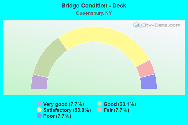
- Bridge Condition - Deck
- 7.7%Very good
- 23.1%Good
- 53.8%Satisfactory
- 7.7%Fair
- 7.7%Poor
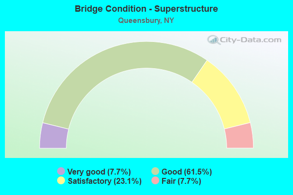
- Bridge Condition - Superstructure
- 7.7%Very good
- 61.5%Good
- 23.1%Satisfactory
- 7.7%Fair
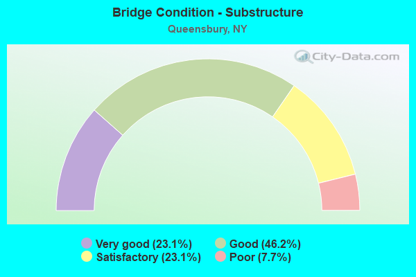
- Bridge Condition - Substructure
- 23.1%Very good
- 46.2%Good
- 23.1%Satisfactory
- 7.7%Poor
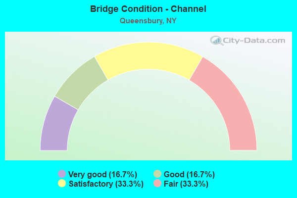
- Bridge Condition - Channel
- 16.7%Very good
- 16.7%Good
- 33.3%Satisfactory
- 33.3%Fair
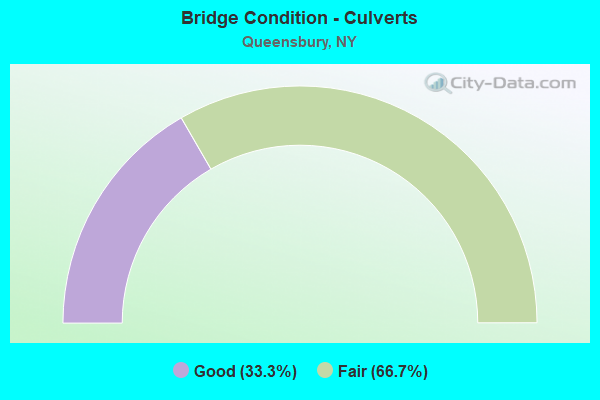
- Bridge Condition - Culverts
- 33.3%Good
- 66.7%Fair
Find on map >> Show street view
Structure Number: 100663, Location: 0.6 MI N JCT 9L + HICKSRD (Lat: 43.358444, Lng: -73.620108), Route carried "on" structure: State highway 9L, Year Built: 2008, Status: Open, Structure Length: 1.37m (4.49ft), Average Daily Traffic: 4,431 (year 2020), Truck Traffic: 7%, Average Future Daily Traffic: 5,382 (year 2040), Design Load: HL 93, Features Intersected: HALFWAY CREEK
Minimum Vertical Clearance: 30+ m (98+ ft), Kilometerpoint: 6.146, Lanes on structure: 2, Base Highway Network: Yes, Owner: State Highway Agency, Approaching Roadway Width: 9.8m (32.2ft), Material/Design: Prestressed concrete, Design/Construction: Slab, Number Of Spans In Main Unit: 1, Length of Maximum Span: 12.8m (42.0ft), Curb-To-Curb Width: 9.8m (32.2ft), Out-to-Out Width: 10.8m (35.4ft)
Condition: Deck: Satisfactory, Superstructure: Very good, Substructure: Very good, Channel: Good, Inventory Rating: 59.9 metric tons, Method Used To Determine Inventory Rating: Load Factor (LF), Structural Evaluation: Equal to present desirable criteria, Deck Geometry: Meets minimum limits, Waterway Adequacy: Superior to present desirable criteria, Approach Roadway Alignment: Equal to present desirable criteria, Length Of Structure Improvement: 1.37m (4.49ft), Designated Inspection Frequency: Every 24 months, Inspection Date: June 2020, Bridge Improvement Cost: $459,000, Roadway Improvement Cost: $269,000, Total Project Cost: $727,000 ( Estimate for 2021), Wearing Surface/Protective System: Wearing Surface: Integral Concrete
Find on map >> Show street view
Structure Number: 100664, Location: 4.8 MI NE JCT RTES 9 & 9L (Lat: 43.442175, Lng: -73.653283), Route carried "on" structure: State highway 9L, Year Built: 1931, Status: Open, Structure Length: 0.82m (2.69ft), Average Daily Traffic: 1,358 (year 2017), Truck Traffic: 10%, Average Future Daily Traffic: 1,416 (year 2040), Features Intersected: INLET TO DUNHAMS BAY
Minimum Vertical Clearance: 30+ m (98+ ft), Kilometerpoint: 22.156, Lanes on structure: 2, Base Highway Network: Yes, Owner: State Highway Agency, Approaching Roadway Width: 8.2m (26.9ft), Material/Design: Steel, Design/Construction: Stringer/Multi-beam, Number Of Spans In Main Unit: 1, Length of Maximum Span: 7.9m (25.9ft), Curb-To-Curb Width: 7.9m (25.9ft), Out-to-Out Width: 8.7m (28.5ft)
Condition: Deck: Poor, Superstructure: Fair, Substructure: Poor, Channel: Satisfactory, Operating Rating: 63.5 metric tons, Method Used To Determine Operating Rating: Load Factor (LF), Inventory Rating: 38.1 metric tons, Method Used To Determine Inventory Rating: Load Factor (LF), Structural Evaluation: Meets minimum limits, Deck Geometry: Meets minimum limits, Waterway Adequacy: Superior to present desirable criteria, Approach Roadway Alignment: Equal to present desirable criteria, Length Of Structure Improvement: 0.82m (2.69ft), Designated Inspection Frequency: Every 24 months, Underwater Inspection Frequency: Every 60 months, Inspection Date: September 2021, Underwater Inspection Date: May 2020, Bridge Improvement Cost: $300,000, Roadway Improvement Cost: $176,000, Total Project Cost: $476,000 ( Estimate for 2021), Deck Structure Type: Concrete Cast-file-Place, Wearing Surface/Protective System: Wearing Surface: Bituminous
Find on map >> Show street view
Structure Number: 1033461, Location: JCT I87 & CR 28 (Lat: 43.297522, Lng: -73.679225), Route carried "on" structure: Interstate 87, Year Built: 1960, Year Reconstructed: 2017, Status: Open, Structure Length: 4.18m (13.71ft), Average Daily Traffic: 21,989 (year 2014), Truck Traffic: 9%, Average Future Daily Traffic: 30,785 (year 2034), Design Load: HS 20, Features Intersected: CORINTH RD-C R 28
Minimum Vertical Clearance: 30+ m (98+ ft), Kilometerpoint: 3.910, Lanes on structure: 3, Lanes under structure: 4, Base Highway Network: Yes, Owner: State Highway Agency, Approaching Roadway Width: 15.8m (51.8ft), Skew: 2 degrees, Material/Design: Steel, Design/Construction: Stringer/Multi-beam, Number Of Spans In Main Unit: 3, Length of Maximum Span: 14.9m (48.9ft), Curb-To-Curb Width: 13.3m (43.6ft), Out-to-Out Width: 14.3m (46.9ft)
Condition: Deck: Satisfactory, Superstructure: Good, Substructure: Very good, Operating Rating: 78.9 metric tons, Method Used To Determine Operating Rating: Load Factor (LF), Inventory Rating: 48.1 metric tons, Method Used To Determine Inventory Rating: Load Factor (LF), Structural Evaluation: Better than present minimum criteria, Deck Geometry: High priority of replacement, Underclear: High priority of corrective action, Approach Roadway Alignment: Equal to present desirable criteria, Length Of Structure Improvement: 4.17m (13.68ft), Designated Inspection Frequency: Every 24 months, Inspection Date: July 2021, Bridge Improvement Cost: $1,337,000, Roadway Improvement Cost: $783,000, Total Project Cost: $2,120,000 ( Estimate for 2021), Deck Structure Type: Concrete Cast-file-Place, Wearing Surface/Protective System: Wearing Surface: Integral Concrete
Find on map >> Show street view
Structure Number: 1033462, Location: JCT I87 & CR 28 (Lat: 43.297569, Lng: -73.678942), Route carried "on" structure: Interstate 87, Year Built: 1960, Year Reconstructed: 2017, Status: Open, Structure Length: 4.18m (13.71ft), Average Daily Traffic: 16,527 (year 2019), Truck Traffic: 18%, Average Future Daily Traffic: 26,189 (year 2040), Design Load: HS 20, Features Intersected: CORINTH RD-C R 28
Minimum Vertical Clearance: 30+ m (98+ ft), Kilometerpoint: 3.910, Lanes on structure: 3, Lanes under structure: 4, Base Highway Network: Yes, Owner: State Highway Agency, Approaching Roadway Width: 15.8m (51.8ft), Skew: 2 degrees, Material/Design: Steel, Design/Construction: Stringer/Multi-beam, Number Of Spans In Main Unit: 3, Length of Maximum Span: 14.9m (48.9ft), Curb-To-Curb Width: 13.3m (43.6ft), Out-to-Out Width: 14.3m (46.9ft)
Condition: Deck: Satisfactory, Superstructure: Good, Substructure: Very good, Operating Rating: 78.9 metric tons, Method Used To Determine Operating Rating: Load Factor (LF), Inventory Rating: 48.1 metric tons, Method Used To Determine Inventory Rating: Load Factor (LF), Structural Evaluation: Better than present minimum criteria, Deck Geometry: High priority of replacement, Underclear: High priority of corrective action, Approach Roadway Alignment: Equal to present desirable criteria, Length Of Structure Improvement: 4.17m (13.68ft), Designated Inspection Frequency: Every 24 months, Inspection Date: July 2021, Bridge Improvement Cost: $1,337,000, Roadway Improvement Cost: $783,000, Total Project Cost: $2,120,000 ( Estimate for 2021), Deck Structure Type: Concrete Cast-file-Place, Wearing Surface/Protective System: Wearing Surface: Integral Concrete
Find on map >> Show street view
Structure Number: 1033471, Location: JCT I87 & LUZERNE RD (Lat: 43.302539, Lng: -73.677853), Route carried "on" structure: Interstate 87, Year Built: 1960, Year Reconstructed: 2019, Status: Open, Structure Length: 4.05m (13.29ft), Average Daily Traffic: 21,989 (year 2014), Truck Traffic: 9%, Average Future Daily Traffic: 30,785 (year 2034), Design Load: H 20, Features Intersected: LUZERNE ROAD
Minimum Vertical Clearance: 30+ m (98+ ft), Kilometerpoint: 4.473, Lanes on structure: 3, Lanes under structure: 2, Base Highway Network: Yes, Owner: State Highway Agency, Approaching Roadway Width: 13.7m (44.9ft), Skew: 1 degrees, Material/Design: Steel, Design/Construction: Stringer/Multi-beam, Number Of Spans In Main Unit: 3, Length of Maximum Span: 18.8m (61.7ft), Curb-To-Curb Width: 13.5m (44.3ft), Out-to-Out Width: 14.4m (47.2ft)
Condition: Deck: Satisfactory, Superstructure: Good, Substructure: Good, Operating Rating: 72.6 metric tons, Method Used To Determine Operating Rating: Load Factor (LF), Inventory Rating: 43.5 metric tons, Method Used To Determine Inventory Rating: Load Factor (LF), Structural Evaluation: Better than present minimum criteria, Deck Geometry: High priority of replacement, Underclear: Somewhat better than minimum adequacy, Approach Roadway Alignment: Equal to present desirable criteria, Length Of Structure Improvement: 4.05m (13.29ft), Designated Inspection Frequency: Every 24 months, Inspection Date: May 2020, Bridge Improvement Cost: $1,306,000, Roadway Improvement Cost: $765,000, Total Project Cost: $2,070,000 ( Estimate for 2021), Deck Structure Type: Concrete Cast-file-Place, Wearing Surface/Protective System: Wearing Surface: Epoxy Overlay
Find on map >> Show street view
Structure Number: 1033472, Location: JCT I87 & LUZERNE RD (Lat: 43.302558, Lng: -73.677575), Route carried "on" structure: Interstate 87, Year Built: 1960, Year Reconstructed: 2019, Status: Open, Structure Length: 4.05m (13.29ft), Average Daily Traffic: 15,818 (year 2019), Truck Traffic: 18%, Average Future Daily Traffic: 25,066 (year 2040), Design Load: H 20, Features Intersected: LUZERNE ROAD
Minimum Vertical Clearance: 30+ m (98+ ft), Kilometerpoint: 4.473, Lanes on structure: 3, Lanes under structure: 2, Base Highway Network: Yes, Owner: State Highway Agency, Approaching Roadway Width: 18.0m (59.1ft), Skew: 1 degrees, Material/Design: Steel, Design/Construction: Stringer/Multi-beam, Number Of Spans In Main Unit: 3, Length of Maximum Span: 18.8m (61.7ft), Curb or Sidewalk Widths: Left: 0.5m (1.6ft), Right: 0.5m (1.6ft), Curb-To-Curb Width: 17.1m (56.1ft), Out-to-Out Width: 18.0m (59.1ft)
Condition: Deck: Satisfactory, Superstructure: Good, Substructure: Good, Operating Rating: 72.6 metric tons, Method Used To Determine Operating Rating: Load Factor (LF), Inventory Rating: 43.5 metric tons, Method Used To Determine Inventory Rating: Load Factor (LF), Structural Evaluation: Better than present minimum criteria, Deck Geometry: Equal to present minimum criteria, Underclear: Somewhat better than minimum adequacy, Approach Roadway Alignment: Equal to present desirable criteria, Length Of Structure Improvement: 4.05m (13.29ft), Designated Inspection Frequency: Every 24 months, Inspection Date: May 2020, Bridge Improvement Cost: $1,635,000, Roadway Improvement Cost: $957,000, Total Project Cost: $2,592,000 ( Estimate for 2021), Deck Structure Type: Concrete Cast-file-Place, Wearing Surface/Protective System: Wearing Surface: Epoxy Overlay
Find on map >> Show street view
Structure Number: 103348, Location: JCT I87 & SHERMAN AVE (Lat: 43.309211, Lng: -73.676019), Route carried "on" structure: Other road , Year Built: 1960, Year Reconstructed: 2018, Status: Open, Structure Length: 6.77m (22.21ft), Average Daily Traffic: 3,979 (year 2020), Truck Traffic: 3%, Average Future Daily Traffic: 4,833 (year 2040), Design Load: H 20, Features Intersected: 87I 87I17101033, RTE I87, Facility Carried by Structure: SHERMAN AVE
Minimum Vertical Clearance: 30+ m (98+ ft), Kilometerpoint: 7.594, Lanes on structure: 2, Lanes under structure: 6, Owner: State Highway Agency, Approaching Roadway Width: 10.7m (35.1ft), Skew: 1 degrees, Material/Design: Steel, Design/Construction: Stringer/Multi-beam, Number Of Spans In Main Unit: 4, Length of Maximum Span: 21.0m (68.9ft), Curb or Sidewalk Widths: Left: 0.5m (1.6ft), Right: 0.5m (1.6ft), Curb-To-Curb Width: 9.1m (29.9ft), Out-to-Out Width: 10.7m (35.1ft)
Condition: Deck: Good, Superstructure: Good, Substructure: Good, Operating Rating: 58.1 metric tons, Method Used To Determine Operating Rating: Load Factor (LF), Inventory Rating: 42.6 metric tons, Method Used To Determine Inventory Rating: Load Factor (LF), Structural Evaluation: Better than present minimum criteria, Deck Geometry: Meets minimum limits, Underclear: High priority of corrective action, Approach Roadway Alignment: Equal to present desirable criteria, Length Of Structure Improvement: 6.76m (22.18ft), Designated Inspection Frequency: Every 24 months, Inspection Date: October 2020, Bridge Improvement Cost: $1,518,000, Roadway Improvement Cost: $889,000, Total Project Cost: $2,406,000 ( Estimate for 2021), Deck Structure Type: Concrete Cast-file-Place, Wearing Surface/Protective System: Wearing Surface: Integral Concrete
Find on map >> Show street view
Structure Number: 1033491, Location: 1 MI S JCT I87 & 254 (Lat: 43.317361, Lng: -73.675850), Route carried "on" structure: Interstate 87, Year Built: 1960, Year Reconstructed: 2016, Status: Open, Structure Length: 4.08m (13.39ft), Average Daily Traffic: 21,989 (year 2014), Truck Traffic: 9%, Average Future Daily Traffic: 22,212 (year 2035), Design Load: HS 20, Features Intersected: DIXON ROAD
Minimum Vertical Clearance: 30+ m (98+ ft), Kilometerpoint: 6.146, Lanes on structure: 3, Lanes under structure: 2, Base Highway Network: Yes, Owner: State Highway Agency, Approaching Roadway Width: 15.8m (51.8ft), Skew: 2 degrees, Material/Design: Steel, Design/Construction: Stringer/Multi-beam, Number Of Spans In Main Unit: 3, Length of Maximum Span: 14.9m (48.9ft), Curb-To-Curb Width: 13.7m (44.9ft), Out-to-Out Width: 14.6m (47.9ft)
Condition: Deck: Good, Superstructure: Good, Substructure: Good, Operating Rating: 71.7 metric tons, Method Used To Determine Operating Rating: Load Factor (LF), Inventory Rating: 42.6 metric tons, Method Used To Determine Inventory Rating: Load Factor (LF), Structural Evaluation: Better than present minimum criteria, Deck Geometry: High priority of corrective action, Underclear: Somewhat better than minimum adequacy, Approach Roadway Alignment: Equal to present desirable criteria, Length Of Structure Improvement: 4.08m (13.39ft), Designated Inspection Frequency: Every 24 months, Inspection Date: August 2020, Bridge Improvement Cost: $1,391,000, Roadway Improvement Cost: $815,000, Total Project Cost: $2,206,000 ( Estimate for 2021), Deck Structure Type: Concrete Cast-file-Place, Wearing Surface/Protective System: Wearing Surface: Integral Concrete
Find on map >> Show street view
Structure Number: 1033492, Location: 1 MI S JCT I87 & SH 254 (Lat: 43.317356, Lng: -73.675425), Route carried "on" structure: Interstate 87, Year Built: 1960, Year Reconstructed: 2016, Status: Open, Structure Length: 4.08m (13.39ft), Average Daily Traffic: 15,818 (year 2019), Truck Traffic: 18%, Average Future Daily Traffic: 25,066 (year 2040), Design Load: HS 20, Features Intersected: DIXON RD
Minimum Vertical Clearance: 30+ m (98+ ft), Kilometerpoint: 6.146, Lanes on structure: 3, Lanes under structure: 2, Base Highway Network: Yes, Owner: State Highway Agency, Approaching Roadway Width: 15.8m (51.8ft), Skew: 1 degrees, Material/Design: Steel, Design/Construction: Stringer/Multi-beam, Number Of Spans In Main Unit: 3, Length of Maximum Span: 14.9m (48.9ft), Curb-To-Curb Width: 13.7m (44.9ft), Out-to-Out Width: 14.6m (47.9ft)
Condition: Deck: Good, Superstructure: Good, Substructure: Good, Operating Rating: 71.7 metric tons, Method Used To Determine Operating Rating: Load Factor (LF), Inventory Rating: 42.6 metric tons, Method Used To Determine Inventory Rating: Load Factor (LF), Structural Evaluation: Better than present minimum criteria, Deck Geometry: High priority of corrective action, Underclear: Somewhat better than minimum adequacy, Approach Roadway Alignment: Equal to present desirable criteria, Length Of Structure Improvement: 4.08m (13.39ft), Designated Inspection Frequency: Every 24 months, Inspection Date: August 2020, Bridge Improvement Cost: $1,393,000, Roadway Improvement Cost: $815,000, Total Project Cost: $2,208,000 ( Estimate for 2021), Deck Structure Type: Concrete Cast-file-Place, Wearing Surface/Protective System: Wearing Surface: Integral Concrete
Find on map >> Show street view
Structure Number: 10335, Location: EXIT 19 OF I87 (Lat: 43.329747, Lng: -73.684194), Route carried "on" structure: State highway 254, Year Built: 1998, Status: Open, Structure Length: 8.87m (29.10ft), Average Daily Traffic: 25,754 (year 2020), Truck Traffic: 3%, Average Future Daily Traffic: 25,875 (year 2040), Design Load: HS 25 or greater, Features Intersected: 87I 87I17101048 NB, RTE
Minimum Vertical Clearance: 30+ m (98+ ft), Kilometerpoint: 0.097, Lanes on structure: 4, Lanes under structure: 6, Base Highway Network: Yes, Owner: State Highway Agency, Approaching Roadway Width: 21.0m (68.9ft), Skew: 1 degrees, Material/Design: Steel continuous, Design/Construction: Stringer/Multi-beam, Number Of Spans In Main Unit: 2, Length of Maximum Span: 43.5m (142.7ft), Curb or Sidewalk Widths: Left: 1.5m (4.9ft), Right: 1.5m (4.9ft), Curb-To-Curb Width: 21.0m (68.9ft), Out-to-Out Width: 24.7m (81.0ft)
Condition: Deck: Satisfactory, Superstructure: Good, Substructure: Good, Operating Rating: 68.0 metric tons, Method Used To Determine Operating Rating: Load Factor (LF), Inventory Rating: 36.3 metric tons, Method Used To Determine Inventory Rating: Load Factor (LF), Structural Evaluation: Better than present minimum criteria, Deck Geometry: Superior to present desirable criteria, Underclear: High priority of corrective action, Approach Roadway Alignment: Equal to present desirable criteria, Length Of Structure Improvement: 8.86m (29.07ft), Designated Inspection Frequency: Every 24 months, Inspection Date: May 2020, Bridge Improvement Cost: $4,750,000, Roadway Improvement Cost: $2,782,000, Total Project Cost: $7,532,000 ( Estimate for 2021), Deck Structure Type: Concrete Cast-file-Place, Wearing Surface/Protective System: Wearing Surface: Integral Concrete, Deck Protection: Epoxy Coated Reinforcing
Find on map >> Show street view
Structure Number: 103351, Location: 2.4 MI N JCT I87 & 254 (Lat: 43.359222, Lng: -73.704397), Route carried "on" structure: County highway 149, Year Built: 1960, Year Reconstructed: 1992, Status: Open, Structure Length: 4.66m (15.29ft), Average Daily Traffic: 8,374 (year 2020), Truck Traffic: 11%, Average Future Daily Traffic: 8,413 (year 2040), Design Load: H 20, Features Intersected: RTE I87
Minimum Vertical Clearance: 30+ m (98+ ft), Kilometerpoint: 0.048, Lanes on structure: 2, Lanes under structure: 3, Base Highway Network: Yes, Owner: State Highway Agency, Approaching Roadway Width: 9.1m (29.9ft), Material/Design: Steel, Design/Construction: Stringer/Multi-beam, Number Of Spans In Main Unit: 3, Length of Maximum Span: 17.3m (56.8ft), Curb or Sidewalk Widths: Left: 0.5m (1.6ft), Right: 0.5m (1.6ft), Curb-To-Curb Width: 9.1m (29.9ft), Out-to-Out Width: 10.7m (35.1ft)
Condition: Deck: Fair, Superstructure: Satisfactory, Substructure: Satisfactory, Operating Rating: 52.6 metric tons, Method Used To Determine Operating Rating: Load Factor (LF), Inventory Rating: 40.8 metric tons, Method Used To Determine Inventory Rating: Load Factor (LF), Structural Evaluation: Equal to present minimum criteria, Deck Geometry: High priority of corrective action, Underclear: Meets minimum limits, Approach Roadway Alignment: Equal to present desirable criteria, Length Of Structure Improvement: 4.66m (15.29ft), Designated Inspection Frequency: Every 24 months, Inspection Date: August 2020, Bridge Improvement Cost: $1,132,000, Roadway Improvement Cost: $663,000, Total Project Cost: $1,795,000 ( Estimate for 2021), Deck Structure Type: Concrete Cast-file-Place, Wearing Surface/Protective System: Wearing Surface: Integral Concrete
Find on map >> Show street view
Structure Number: 106903, Location: 0.6 MI SE JCT 9 & 254 (Lat: 43.325903, Lng: -73.664314), Route carried "on" structure: US 9, Year Built: 1971, Year Reconstructed: 2009, Status: Open, Structure Length: 0.91m (2.99ft), Average Daily Traffic: 9,692 (year 2018), Truck Traffic: 2%, Average Future Daily Traffic: 9,737 (year 2040), Features Intersected: HALFWAY CREEK
Minimum Vertical Clearance: 30+ m (98+ ft), Kilometerpoint: 2.961, Lanes on structure: 4, Base Highway Network: Yes, Owner: State Highway Agency, Approaching Roadway Width: 16.5m (54.1ft), Skew: 20 degrees, Material/Design: Steel, Design/Construction: Culvert, Number Of Spans In Main Unit: 4, Length of Maximum Span: 1.8m (5.9ft), Curb or Sidewalk Widths: Left: 1.5m (4.9ft), Right: 1.5m (4.9ft)
Condition: Channel: Fair, Culverts: Good, Operating Rating: 73.8 metric tons, Method Used To Determine Operating Rating: Field evaluation and documented engineering judgment, Inventory Rating: 32.7 metric tons, Method Used To Determine Inventory Rating: Field evaluation and documented engineering judgment, Structural Evaluation: Better than present minimum criteria, Waterway Adequacy: Superior to present desirable criteria, Approach Roadway Alignment: Equal to present desirable criteria, Length Of Structure Improvement: 0.91m (2.99ft), Designated Inspection Frequency: Every 24 months, Inspection Date: June 2020, Bridge Improvement Cost: $265,000, Roadway Improvement Cost: $155,000, Total Project Cost: $421,000 ( Estimate for 2021), Wearing Surface/Protective System: Wearing Surface: Bituminous
Find on map >> Show street view
Structure Number: 109586, Location: 2.5 MI N JCT I87 & 254 (Lat: 43.359136, Lng: -73.703478), Route carried "on" structure: State highway 149, Year Built: 1960, Year Reconstructed: 1992, Status: Open, Structure Length: 4.27m (14.01ft), Average Daily Traffic: 8,374 (year 2020), Truck Traffic: 11%, Average Future Daily Traffic: 8,413 (year 2040), Design Load: H 20, Features Intersected: RTE I87
Minimum Vertical Clearance: 30+ m (98+ ft), Kilometerpoint: 0.129, Lanes on structure: 2, Lanes under structure: 3, Base Highway Network: Yes, Owner: State Highway Agency, Approaching Roadway Width: 9.1m (29.9ft), Material/Design: Steel, Design/Construction: Stringer/Multi-beam, Number Of Spans In Main Unit: 3, Length of Maximum Span: 17.3m (56.8ft), Curb or Sidewalk Widths: Left: 0.5m (1.6ft), Right: 0.5m (1.6ft), Curb-To-Curb Width: 9.1m (29.9ft), Out-to-Out Width: 10.7m (35.1ft)
Condition: Deck: Satisfactory, Superstructure: Satisfactory, Substructure: Satisfactory, Operating Rating: 53.5 metric tons, Method Used To Determine Operating Rating: Load Factor (LF), Inventory Rating: 31.8 metric tons, Method Used To Determine Inventory Rating: Load Factor (LF), Structural Evaluation: Equal to present minimum criteria, Deck Geometry: High priority of corrective action, Underclear: High priority of corrective action, Approach Roadway Alignment: Equal to present desirable criteria, Length Of Structure Improvement: 4.26m (13.98ft), Designated Inspection Frequency: Every 24 months, Inspection Date: August 2020, Bridge Improvement Cost: $1,025,000, Roadway Improvement Cost: $601,000, Total Project Cost: $1,626,000 ( Estimate for 2021), Deck Structure Type: Concrete Cast-file-Place, Wearing Surface/Protective System: Wearing Surface: Integral Concrete
Find on map >> Show street view
Structure Number: 336032, Location: 1 MI E JCT US 9 & SH 254 (Lat: 43.332617, Lng: -73.652922), Route carried "on" structure: County highway , Year Built: 1975, Status: Open, Structure Length: 0.91m (2.99ft), Average Daily Traffic: 15,076 (year 2011), Truck Traffic: 6%, Average Future Daily Traffic: 18,314 (year 2040), Design Load: HS 20, Features Intersected: HALFWAY CREEK, Facility Carried by Structure: COUNTY ROAD 7
Minimum Vertical Clearance: 30+ m (98+ ft), Kilometerpoint: 0.837, Lanes on structure: 5, Owner: County Highway Agency, Approaching Roadway Width: 19.8m (65.0ft), Skew: 21 degrees, Material/Design: Steel, Design/Construction: Culvert, Number Of Spans In Main Unit: 3, Length of Maximum Span: 2.4m (7.9ft), Curb or Sidewalk Widths: Left: 1.9m (6.2ft), Right: 1.9m (6.2ft)
Condition: Channel: Fair, Culverts: Fair, Operating Rating: 73.5 metric tons, Method Used To Determine Operating Rating: Field evaluation and documented engineering judgment, Inventory Rating: 19.6 metric tons, Method Used To Determine Inventory Rating: Field evaluation and documented engineering judgment, Structural Evaluation: Meets minimum limits, Waterway Adequacy: Meets minimum limits, Approach Roadway Alignment: Better than present minimum criteria, Length Of Structure Improvement: 0.91m (2.99ft), Designated Inspection Frequency: Every 24 months, Inspection Date: June 2021, Bridge Improvement Cost: $319,000, Roadway Improvement Cost: $187,000, Total Project Cost: $506,000 ( Estimate for 2021)
Find on map >> Show street view
Structure Number: 406061, Location: JCT RTE 254 & FEEDER C (Lat: 43.310922, Lng: -73.606856), Route carried "on" structure: State highway 254, Year Built: 1952, Status: Open, Structure Length: 1.40m (4.59ft), Average Daily Traffic: 10,246 (year 2017), Truck Traffic: 4%, Average Future Daily Traffic: 12,446 (year 2040), Design Load: H 20, Features Intersected: GLENS FALLS FEEDER CANAL
Minimum Vertical Clearance: 30+ m (98+ ft), Kilometerpoint: 7.578, Lanes on structure: 4, Base Highway Network: Yes, Owner: State Highway Agency, Approaching Roadway Width: 13.4m (44.0ft), Skew: 6 degrees, Material/Design: Steel, Design/Construction: Culvert, Number Of Spans In Main Unit: 1, Length of Maximum Span: 13.7m (44.9ft), Curb or Sidewalk Widths: Left: 1.5m (4.9ft), Right: 0.0m
Condition: Channel: Satisfactory, Culverts: Fair, Operating Rating: 55.4 metric tons, Method Used To Determine Operating Rating: Field evaluation and documented engineering judgment, Inventory Rating: 14.3 metric tons, Method Used To Determine Inventory Rating: Field evaluation and documented engineering judgment, Structural Evaluation: High priority of corrective action, Waterway Adequacy: Superior to present desirable criteria, Approach Roadway Alignment: Equal to present desirable criteria, Length Of Structure Improvement: 1.40m (4.59ft), Designated Inspection Frequency: Every 24 months, Inspection Date: April 2020, Bridge Improvement Cost: $391,000, Roadway Improvement Cost: $229,000, Total Project Cost: $620,000 ( Estimate for 2021), Wearing Surface/Protective System: Wearing Surface: Bituminous
Find on map >> Show street view
Structure Number: 441705, Location: .2 MI W JCT SH 32 & SH254 (Lat: 43.309897, Lng: -73.617272), Route carried "on" structure: City street , Year Built: 1930, Year Reconstructed: 2020, Status: Open, Structure Length: 1.77m (5.81ft), Average Daily Traffic: 36 (year 2017), Truck Traffic: 5%, Average Future Daily Traffic: 50 (year 2037), Features Intersected: Bike path, FEEDER CANAL, Facility Carried by Structure: BRAYTON AVENUE
Minimum Vertical Clearance: 30+ m (98+ ft), Kilometerpoint: 0.032, Lanes on structure: 1, Owner: State Highway Agency, Approaching Roadway Width: 4.3m (14.1ft), Navigation Control: Yes ( Vertical Clearance: 999.9m (3,280.5ft), Horizontal Clearance: 4.3m (14.1ft)), Material/Design: Steel, Design/Construction: Stringer/Multi-beam, Number Of Spans In Main Unit: 1, Length of Maximum Span: 15.5m (50.9ft), Curb or Sidewalk Widths: Left: 0.5m (1.6ft), Right: 0.5m (1.6ft), Curb-To-Curb Width: 4.3m (14.1ft), Out-to-Out Width: 5.9m (19.4ft)
Condition: Deck: Very good, Superstructure: Satisfactory, Substructure: Satisfactory, Channel: Very good, Operating Rating: 67.1 metric tons, Method Used To Determine Operating Rating: Load Factor (LF), Inventory Rating: 39.9 metric tons, Method Used To Determine Inventory Rating: Load Factor (LF), Structural Evaluation: Equal to present minimum criteria, Deck Geometry: Equal to present minimum criteria, Waterway Adequacy: Equal to present minimum criteria, Approach Roadway Alignment: Meets minimum limits, Length Of Structure Improvement: 1.76m (5.77ft), Designated Inspection Frequency: Every 24 months, Inspection Date: November 2020, Bridge Improvement Cost: $409,000, Roadway Improvement Cost: $239,000, Total Project Cost: $648,000 ( Estimate for 2021), Deck Structure Type: Concrete Cast-file-Place, Wearing Surface/Protective System: Wearing Surface: Integral Concrete
Find on map >> Show street view
Structure Number: 1033461, Location: JCT I87 & CR 28 (Lat: 43.297522, Lng: -73.679225), Route carried "under" structure: County highway , Year Built: 1960, Structure Length: 0. m, Average Daily Traffic: 3,445 (year 2018), Truck Traffic: 5%, Features Intersected: CORINTH RD-C R 28, Facility Carried by Structure: RTE I87
Minimum Vertical Clearance: 4.60m (15.09ft), Kilometerpoint: 6.838, Lanes on structure: 3, Lanes under structure: 4, Material/Design: Steel, Design/Construction: Stringer/Multi-beam, Length of Maximum Span: 14.9m (48.9ft)
Find on map >> Show street view
Structure Number: 1033462, Location: JCT I87 & CR 28 (Lat: 43.297569, Lng: -73.678942), Route carried "under" structure: County highway , Year Built: 1960, Structure Length: 0. m, Average Daily Traffic: 3,445 (year 2018), Truck Traffic: 5%, Features Intersected: CORINTH RD-C R 28, Facility Carried by Structure: RTE I87
Minimum Vertical Clearance: 4.67m (15.32ft), Kilometerpoint: 6.903, Lanes on structure: 3, Lanes under structure: 4, Material/Design: Steel, Design/Construction: Stringer/Multi-beam, Length of Maximum Span: 14.9m (48.9ft)
Find on map >> Show street view
Structure Number: 1033471, Location: JCT I87 & LUZERNE RD (Lat: 43.302539, Lng: -73.677853), Route carried "under" structure: City street , Year Built: 1960, Structure Length: 0. m, Average Daily Traffic: 1,533 (year 2018), Truck Traffic: 3%, Features Intersected: LUZERNE ROAD, Facility Carried by Structure: RTE I87
Minimum Vertical Clearance: 4.72m (15.49ft), Kilometerpoint: 2.156, Lanes on structure: 3, Lanes under structure: 2, Material/Design: Steel, Design/Construction: Stringer/Multi-beam, Length of Maximum Span: 18.8m (61.7ft)
Find on map >> Show street view
Structure Number: 1033472, Location: JCT I87 & LUZERNE RD (Lat: 43.302558, Lng: -73.677575), Route carried "under" structure: City street , Year Built: 1960, Structure Length: 0. m, Average Daily Traffic: 1,533 (year 2018), Truck Traffic: 3%, Features Intersected: LUZERNE ROAD, Facility Carried by Structure: RTE I87
Minimum Vertical Clearance: 4.67m (15.32ft), Kilometerpoint: 6.613, Lanes on structure: 3, Lanes under structure: 2, Material/Design: Steel, Design/Construction: Stringer/Multi-beam, Length of Maximum Span: 18.8m (61.7ft)
Find on map >> Show street view
Structure Number: 103348, Location: JCT I87 & SHERMAN AVE (Lat: 43.309211, Lng: -73.676019), Route carried "under" structure: Interstate 87, Year Built: 1960, Structure Length: 0. m, Average Daily Traffic: 9,321 (year 1998), Features Intersected: 87I 87I17101033, RTE I87, Facility Carried by Structure: SHERMAN AVE
Minimum Vertical Clearance: 4.74m (15.55ft), Kilometerpoint: 5.278, Lanes on structure: 2, Lanes under structure: 3, Material/Design: Steel, Design/Construction: Stringer/Multi-beam, Length of Maximum Span: 21.0m (68.9ft)
Find on map >> Show street view
Structure Number: 1033491, Location: 1 MI S JCT I87 & 254 (Lat: 43.317361, Lng: -73.675850), Route carried "under" structure: Other road , Year Built: 1960, Structure Length: 0. m, Average Daily Traffic: 1,260 (year 2019), Truck Traffic: 3%, Features Intersected: DIXON ROAD, Facility Carried by Structure: RTE I87
Minimum Vertical Clearance: 4.42m (14.50ft), Kilometerpoint: 0.000, Lanes on structure: 3, Lanes under structure: 2, Material/Design: Steel, Design/Construction: Stringer/Multi-beam, Length of Maximum Span: 14.9m (48.9ft)
Find on map >> Show street view
Structure Number: 1033492, Location: 1 MI S JCT I87 & SH 254 (Lat: 43.317356, Lng: -73.675425), Route carried "under" structure: Other road , Year Built: 1960, Structure Length: 0. m, Average Daily Traffic: 1,260 (year 2019), Truck Traffic: 3%, Features Intersected: DIXON RD, Facility Carried by Structure: RTE I87
Minimum Vertical Clearance: 4.50m (14.76ft), Kilometerpoint: 2.510, Lanes on structure: 3, Lanes under structure: 2, Material/Design: Steel, Design/Construction: Stringer/Multi-beam, Length of Maximum Span: 14.9m (48.9ft)
Find on map >> Show street view
Structure Number: 10335, Location: EXIT 19 OF I87 (Lat: 43.329747, Lng: -73.684194), Route carried "under" structure: Interstate 87, Year Built: 1998, Structure Length: 0. m, Average Daily Traffic: 9,321 (year 1998), Features Intersected: 87I 87I17101048 NB, RTE, Facility Carried by Structure: RTE 254
Minimum Vertical Clearance: 5.10m (16.73ft), Kilometerpoint: 7.868, Lanes on structure: 4, Lanes under structure: 3, Material/Design: Steel continuous, Design/Construction: Stringer/Multi-beam, Length of Maximum Span: 43.5m (142.7ft)
Find on map >> Show street view
Structure Number: 103351, Location: 2.4 MI N JCT I87 & 254 (Lat: 43.359222, Lng: -73.704397), Route carried "under" structure: Interstate 87, Year Built: 1960, Structure Length: 0. m, Average Daily Traffic: 9,321 (year 1998), Features Intersected: RTE I87, Facility Carried by Structure: RTE 149
Minimum Vertical Clearance: 6.01m (19.72ft), Kilometerpoint: 11.762, Lanes on structure: 2, Lanes under structure: 3, Material/Design: Steel, Design/Construction: Stringer/Multi-beam, Length of Maximum Span: 17.3m (56.8ft)
Find on map >> Show street view
Structure Number: 109586, Location: 2.5 MI N JCT I87 & 254 (Lat: 43.359136, Lng: -73.703478), Route carried "under" structure: Interstate 87, Year Built: 1960, Structure Length: 0. m, Average Daily Traffic: 9,321 (year 1998), Features Intersected: RTE I87, Facility Carried by Structure: RTE 149
Minimum Vertical Clearance: 5.05m (16.57ft), Kilometerpoint: 11.762, Lanes on structure: 2, Lanes under structure: 3, Material/Design: Steel, Design/Construction: Stringer/Multi-beam, Length of Maximum Span: 17.3m (56.8ft)
Find on map >> Show street view
Structure Number: 336699, Location: .25 MI.E.JCT.RTE.9&149 (Lat: 43.370186, Lng: -73.694403), Route carried "under" structure: State highway 149, Year Built: 1981, Structure Length: 0. m, Average Daily Traffic: 10,221 (year 2002), Features Intersected: RTE 149, Facility Carried by Structure: COUNTY BIKE PATH
Minimum Vertical Clearance: 5.21m (17.09ft), Kilometerpoint: 1.319, Lanes under structure: 2, Material/Design: Steel, Design/Construction: Truss - Thru, Length of Maximum Span: 27.4m (89.9ft)