Bridge Statistics for Ragland, Alabama (AL)
Condition, Traffic, Stress, Structural Evaluation, Project Costs
- National Bridge Inventory (NBI) Statistics
- 14Number of bridges
- 118ft / 35.6mTotal length
- $10,873,000Total costs
- 23,379Total average daily traffic
- 1,848Total average daily truck traffic
- National Bridge Inventory (NBI) Registered Bridges for Ragland
- No street view available for this location
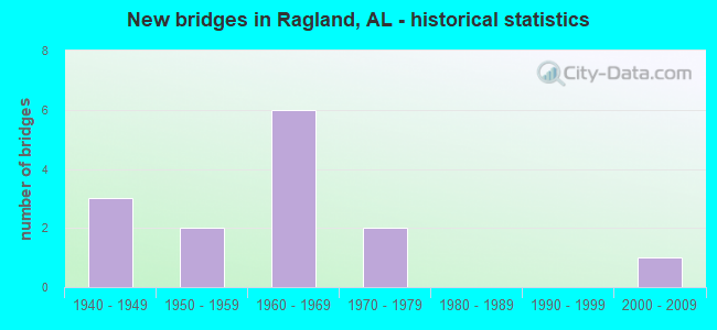
- New bridges - historical statistics
- 31940-1949
- 21950-1959
- 61960-1969
- 21970-1979
- 12000-2009
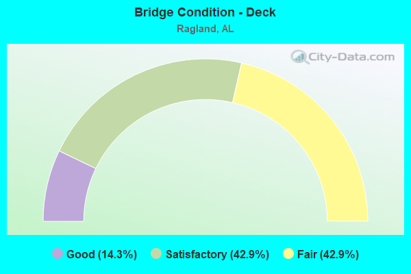
- Bridge Condition - Deck
- 14.3%Good
- 42.9%Satisfactory
- 42.9%Fair

- Bridge Condition - Superstructure
- 42.9%Good
- 57.1%Satisfactory
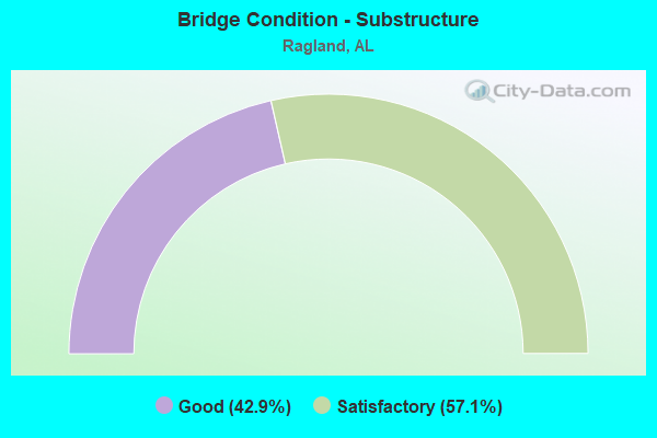
- Bridge Condition - Substructure
- 42.9%Good
- 57.1%Satisfactory
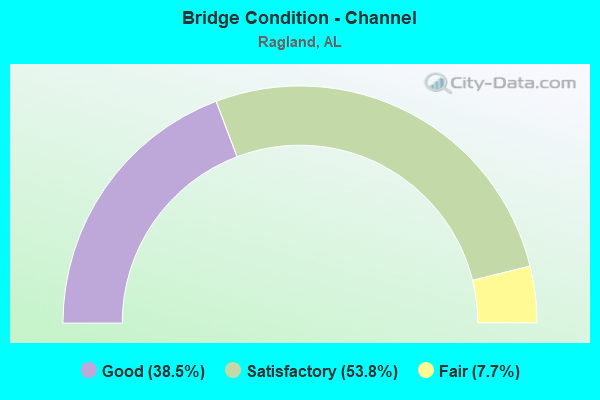
- Bridge Condition - Channel
- 38.5%Good
- 53.8%Satisfactory
- 7.7%Fair
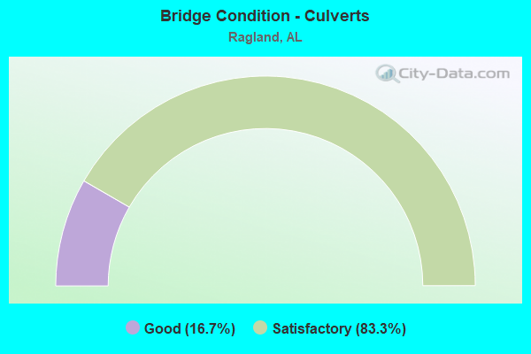
- Bridge Condition - Culverts
- 16.7%Good
- 83.3%Satisfactory
Find on map >> Show street view
Structure Number: 2458, Location: 5.5 MI. NO. US 231 (Lat: 33.703200, Lng: -86.203000), Route carried "on" structure: State highway 144, Year Built: 1940, Status: Open, Structure Length: 1.03m (3.38ft), Average Daily Traffic: 2,578 (year 2021), Truck Traffic: 10%, Average Future Daily Traffic: 3,942 (year 2041), Design Load: H 15, Features Intersected: SHELOR CREEK
Minimum Vertical Clearance: 30+ m (98+ ft), Kilometerpoint: 8.913, Lanes on structure: 2, Owner: State Highway Agency, Approaching Roadway Width: 8.5m (27.9ft), Material/Design: Concrete, Design/Construction: Culvert, Number Of Spans In Main Unit: 3, Length of Maximum Span: 3.0m (9.8ft)
Condition: Channel: Satisfactory, Culverts: Satisfactory, Operating Rating: 84.3 metric tons, Method Used To Determine Operating Rating: Load Factor (LF), Inventory Rating: 50.5 metric tons, Method Used To Determine Inventory Rating: Load Factor (LF), Structural Evaluation: Equal to present minimum criteria, Waterway Adequacy: Equal to present minimum criteria, Approach Roadway Alignment: Equal to present desirable criteria, Length Of Structure Improvement: 1.70m (5.58ft), Designated Inspection Frequency: Every 24 months, Other Special Inspection Frequency: Every 12 months, Inspection Date: April 2021, Other Special Inspection Date: April 2021, Bridge Improvement Cost: $304,000, Roadway Improvement Cost: $30,000, Total Project Cost: $334,000 ( Estimate for 2022), Wearing Surface/Protective System: Wearing Surface: Bituminous
Find on map >> Show street view
Structure Number: 2459, Location: @ RAGLAND FIRE DEPT/CITY (Lat: 33.741111, Lng: -86.155833), Route carried "on" structure: State highway 144, Year Built: 1940, Status: Open, Structure Length: 0.69m (2.26ft), Average Daily Traffic: 3,170 (year 2021), Truck Traffic: 8%, Average Future Daily Traffic: 3,755 (year 2041), Features Intersected: TROUT CREEK
Minimum Vertical Clearance: 30+ m (98+ ft), Kilometerpoint: 16.016, Lanes on structure: 2, Owner: State Highway Agency, Approaching Roadway Width: 8.5m (27.9ft), Skew: 3 degrees, Material/Design: Concrete, Design/Construction: Culvert, Number Of Spans In Main Unit: 2, Length of Maximum Span: 3.0m (9.8ft), Curb or Sidewalk Widths: Left: 0.9m (3.0ft), Right: 0.0m
Condition: Channel: Fair, Culverts: Satisfactory, Operating Rating: 43.5 metric tons, Method Used To Determine Operating Rating: Field evaluation and documented engineering judgment, Inventory Rating: 32.7 metric tons, Method Used To Determine Inventory Rating: Field evaluation and documented engineering judgment, Structural Evaluation: Equal to present minimum criteria, Waterway Adequacy: Equal to present desirable criteria, Approach Roadway Alignment: Equal to present desirable criteria, Length Of Structure Improvement: 1.32m (4.33ft), Designated Inspection Frequency: Every 24 months, Inspection Date: April 2021, Bridge Improvement Cost: $359,000, Roadway Improvement Cost: $36,000, Total Project Cost: $395,000 ( Estimate for 2022), Wearing Surface/Protective System: Wearing Surface: Bituminous
Find on map >> Show street view
Structure Number: 3295, Location: 0 6 E RAGLAND (Lat: 33.749069, Lng: -86.122325), Route carried "on" structure: ServiceCounty highway 61, Year Built: 1948, Status: Posted for load, Structure Length: 0.73m (2.40ft), Average Daily Traffic: 520 (year 1999), Truck Traffic: 10%, Average Future Daily Traffic: 821 (year 2029), Design Load: H 15, Features Intersected: GREEN BRANCH, Facility Carried by Structure: ST CLAIR CO 66
Minimum Vertical Clearance: 30+ m (98+ ft), Kilometerpoint: 0.010, Lanes on structure: 2, Owner: County Highway Agency, Approaching Roadway Width: 8.5m (27.9ft), Material/Design: Steel, Design/Construction: Stringer/Multi-beam, Number Of Spans In Main Unit: 1, Length of Maximum Span: 6.7m (22.0ft), Curb-To-Curb Width: 8.5m (27.9ft), Out-to-Out Width: 8.5m (27.9ft)
Condition: Deck: Satisfactory, Superstructure: Satisfactory, Substructure: Satisfactory, Channel: Good, Operating Rating: 2.7 metric tons, Method Used To Determine Operating Rating: Load Factor (LF), Inventory Rating: 1.8 metric tons, Method Used To Determine Inventory Rating: Load Factor (LF), Structural Evaluation: High priority of replacement, Deck Geometry: Somewhat better than minimum adequacy, Waterway Adequacy: Better than present minimum criteria, Approach Roadway Alignment: Equal to present minimum criteria, Bridge Posting: Required (Relationship of Operating Rating to Maximum Legal Load: > 39.9% below), Length Of Structure Improvement: 1.38m (4.53ft), Designated Inspection Frequency: Every 24 months, Other Special Inspection Frequency: Every 3 months, Inspection Date: October 2021, Other Special Inspection Date: January 2022, Bridge Improvement Cost: $255,000, Roadway Improvement Cost: $26,000, Total Project Cost: $281,000 ( Estimate for 2022), Deck Structure Type: Concrete Cast-file-Place, Wearing Surface/Protective System: Wearing Surface: Bituminous
Find on map >> Show street view
Structure Number: 5281, Location: BOILING SPRINGS RD. (Lat: 33.705025, Lng: -86.102861), Route carried "on" structure: County highway 73, Year Built: 1955, Status: Posted for load, Structure Length: 5.18m (16.99ft), Average Daily Traffic: 1,032 (year 2005), Truck Traffic: 5%, Average Future Daily Traffic: 2,105 (year 2041), Design Load: H 15, Features Intersected: ACKER CREEK, Facility Carried by Structure: 3 MI W AL 77
Minimum Vertical Clearance: 30+ m (98+ ft), Kilometerpoint: 0.010, Lanes on structure: 2, Owner: County Highway Agency, Approaching Roadway Width: 10.4m (34.1ft), Material/Design: Concrete, Design/Construction: Tee Beam, Number Of Spans In Main Unit: 5, Length of Maximum Span: 10.4m (34.1ft), Curb-To-Curb Width: 6.6m (21.7ft), Out-to-Out Width: 7.2m (23.6ft)
Condition: Deck: Satisfactory, Superstructure: Good, Substructure: Satisfactory, Channel: Satisfactory, Operating Rating: 37.6 metric tons, Method Used To Determine Operating Rating: Load Factor (LF), Inventory Rating: 22.6 metric tons, Method Used To Determine Inventory Rating: Load Factor (LF), Structural Evaluation: Equal to present minimum criteria, Deck Geometry: High priority of replacement, Waterway Adequacy: Equal to present minimum criteria, Approach Roadway Alignment: Equal to present minimum criteria, Bridge Posting: Required (Relationship of Operating Rating to Maximum Legal Load: 0.1 - 9.9% below), Length Of Structure Improvement: 6.20m (20.34ft), Designated Inspection Frequency: Every 24 months, Other Special Inspection Frequency: Every 12 months, Inspection Date: May 2021, Other Special Inspection Date: May 2021, Bridge Improvement Cost: $978,000, Roadway Improvement Cost: $98,000, Total Project Cost: $1,076,000 ( Estimate for 2022), Deck Structure Type: Concrete Cast-file-Place
Find on map >> Show street view
Structure Number: 5282, Location: BOILING SPRINGS RD. (Lat: 33.722433, Lng: -86.077597), Route carried "on" structure: County highway 73, Year Built: 1955, Status: Posted for load, Structure Length: 10.36m (33.99ft), Average Daily Traffic: 1,032 (year 2005), Truck Traffic: 5%, Average Future Daily Traffic: 2,105 (year 2041), Design Load: H 15, Features Intersected: CANE CREEK, Facility Carried by Structure: 2 MI W AL 77
Minimum Vertical Clearance: 30+ m (98+ ft), Kilometerpoint: 0.010, Lanes on structure: 2, Owner: County Highway Agency, Approaching Roadway Width: 8.5m (27.9ft), Material/Design: Concrete, Design/Construction: Tee Beam, Number Of Spans In Main Unit: 10, Length of Maximum Span: 10.4m (34.1ft), Curb-To-Curb Width: 6.6m (21.7ft), Out-to-Out Width: 7.1m (23.3ft)
Condition: Deck: Satisfactory, Superstructure: Good, Substructure: Good, Channel: Good, Operating Rating: 41.7 metric tons, Method Used To Determine Operating Rating: Load Factor (LF), Inventory Rating: 25.4 metric tons, Method Used To Determine Inventory Rating: Load Factor (LF), Structural Evaluation: Equal to present minimum criteria, Deck Geometry: High priority of replacement, Waterway Adequacy: Better than present minimum criteria, Approach Roadway Alignment: Equal to present minimum criteria, Bridge Posting: Required (Relationship of Operating Rating to Maximum Legal Load: > 39.9% below), Length Of Structure Improvement: 11.28m (37.01ft), Designated Inspection Frequency: Every 24 months, Other Special Inspection Frequency: Every 12 months, Inspection Date: May 2021, Other Special Inspection Date: April 2021, Bridge Improvement Cost: $1,778,000, Roadway Improvement Cost: $178,000, Total Project Cost: $1,956,000 ( Estimate for 2022), Deck Structure Type: Concrete Cast-file-Place
Find on map >> Show street view
Structure Number: 8027, Location: IN RAGLAND (Lat: 33.717136, Lng: -86.143867), Route carried "on" structure: ServiceCounty highway 69, Year Built: 1963, Status: Open, Structure Length: 3.04m (9.97ft), Average Daily Traffic: 550 (year 1999), Truck Traffic: 10%, Average Future Daily Traffic: 844 (year 2029), Design Load: H 15, Features Intersected: TROUT CREEK, Facility Carried by Structure: ST CLAIR CO HWY 6
Minimum Vertical Clearance: 30+ m (98+ ft), Kilometerpoint: 0.010, Lanes on structure: 2, Owner: County Highway Agency, Approaching Roadway Width: 8.5m (27.9ft), Material/Design: Steel, Design/Construction: Stringer/Multi-beam, Number Of Spans In Main Unit: 3, Length of Maximum Span: 15.2m (49.9ft), Curb-To-Curb Width: 6.7m (22.0ft), Out-to-Out Width: 7.3m (24.0ft)
Condition: Deck: Fair, Superstructure: Satisfactory, Substructure: Satisfactory, Channel: Good, Operating Rating: 51.5 metric tons, Method Used To Determine Operating Rating: Load Factor (LF), Inventory Rating: 30.8 metric tons, Method Used To Determine Inventory Rating: Load Factor (LF), Structural Evaluation: Equal to present minimum criteria, Deck Geometry: Meets minimum limits, Waterway Adequacy: Equal to present desirable criteria, Approach Roadway Alignment: Equal to present minimum criteria, Length Of Structure Improvement: 3.88m (12.73ft), Designated Inspection Frequency: Every 24 months, Inspection Date: March 2021, Bridge Improvement Cost: $639,000, Roadway Improvement Cost: $64,000, Total Project Cost: $703,000 ( Estimate for 2022), Deck Structure Type: Concrete Cast-file-Place
Find on map >> Show street view
Structure Number: 8311, Location: 1 8 MI E FAIRVIEW CHURCH (Lat: 33.736372, Lng: -86.177464), Route carried "on" structure: ServiceCounty highway 29, Year Built: 1964, Status: Open, Structure Length: 5.18m (16.99ft), Average Daily Traffic: 600 (year 1999), Truck Traffic: 15%, Average Future Daily Traffic: 1,407 (year 2029), Design Load: H 15, Features Intersected: TROUT CREEK, Facility Carried by Structure: ST CLAIR CO 26
Minimum Vertical Clearance: 30+ m (98+ ft), Kilometerpoint: 0.010, Lanes on structure: 2, Owner: County Highway Agency, Approaching Roadway Width: 7.3m (24.0ft), Material/Design: Concrete, Design/Construction: Tee Beam, Number Of Spans In Main Unit: 2, Number Of Approach Spans: 3, Length of Maximum Span: 10.4m (34.1ft), Curb-To-Curb Width: 6.7m (22.0ft), Out-to-Out Width: 7.3m (24.0ft)
Condition: Deck: Fair, Superstructure: Satisfactory, Substructure: Good, Channel: Satisfactory, Operating Rating: 42.9 metric tons, Method Used To Determine Operating Rating: Load Factor (LF), Inventory Rating: 25.8 metric tons, Method Used To Determine Inventory Rating: Load Factor (LF), Structural Evaluation: Equal to present minimum criteria, Deck Geometry: Meets minimum limits, Waterway Adequacy: Equal to present desirable criteria, Approach Roadway Alignment: Better than present minimum criteria, Length Of Structure Improvement: 6.20m (20.34ft), Designated Inspection Frequency: Every 24 months, Inspection Date: March 2021, Bridge Improvement Cost: $1,021,000, Roadway Improvement Cost: $102,000, Total Project Cost: $1,123,000 ( Estimate for 2022), Deck Structure Type: Concrete Cast-file-Place
Find on map >> Show street view
Structure Number: 9091, Location: 1.5 MI NW FAIRVIEW CHURCH (Lat: 33.758033, Lng: -86.217506), Route carried "on" structure: ServiceCounty highway 29, Year Built: 1966, Status: Open, Structure Length: 0.78m (2.56ft), Average Daily Traffic: 500 (year 1999), Truck Traffic: 10%, Average Future Daily Traffic: 1,407 (year 2029), Design Load: H 15, Features Intersected: LITTLE TROUT CREEK, Facility Carried by Structure: ST CLAIR CO 26
Minimum Vertical Clearance: 30+ m (98+ ft), Kilometerpoint: 0.010, Lanes on structure: 2, Owner: County Highway Agency, Approaching Roadway Width: 11.6m (38.1ft), Skew: 3 degrees, Material/Design: Concrete continuous, Design/Construction: Culvert, Number Of Spans In Main Unit: 2, Length of Maximum Span: 3.4m (11.2ft), Curb-To-Curb Width: 22.2m (72.8ft), Out-to-Out Width: 22.2m (72.8ft)
Condition: Channel: Good, Culverts: Good, Operating Rating: 88.9 metric tons, Method Used To Determine Operating Rating: Load Factor (LF), Inventory Rating: 88.9 metric tons, Method Used To Determine Inventory Rating: Load Factor (LF), Structural Evaluation: Better than present minimum criteria, Deck Geometry: Superior to present desirable criteria, Waterway Adequacy: Better than present minimum criteria, Approach Roadway Alignment: Better than present minimum criteria, Length Of Structure Improvement: 1.44m (4.72ft), Designated Inspection Frequency: Every 24 months, Inspection Date: Febuary 2021, Bridge Improvement Cost: $698,000, Roadway Improvement Cost: $70,000, Total Project Cost: $768,000 ( Estimate for 2022), Deck Structure Type: Concrete Cast-file-Place
Find on map >> Show street view
Structure Number: 9126, Location: 0 3 MI S MT ZION CHURCH (Lat: 33.802353, Lng: -86.117119), Route carried "on" structure: County highway 64, Year Built: 1966, Status: Posted for load, Structure Length: 5.18m (16.99ft), Average Daily Traffic: 400 (year 1999), Truck Traffic: 5%, Average Future Daily Traffic: 703 (year 2029), Features Intersected: SHOUL CREEK, Facility Carried by Structure: ST CLAIR CO HW 21
Minimum Vertical Clearance: 30+ m (98+ ft), Kilometerpoint: 0.010, Lanes on structure: 2, Owner: County Highway Agency, Approaching Roadway Width: 8.5m (27.9ft), Material/Design: Concrete, Design/Construction: Tee Beam, Number Of Spans In Main Unit: 5, Length of Maximum Span: 10.4m (34.1ft), Curb-To-Curb Width: 6.1m (20.0ft), Out-to-Out Width: 7.3m (24.0ft)
Condition: Deck: Good, Superstructure: Good, Substructure: Good, Channel: Good, Operating Rating: 39.6 metric tons, Method Used To Determine Operating Rating: Allowable Stress (AS), Inventory Rating: 23.3 metric tons, Method Used To Determine Inventory Rating: Allowable Stress (AS), Structural Evaluation: Equal to present minimum criteria, Deck Geometry: Meets minimum limits, Waterway Adequacy: Equal to present desirable criteria, Approach Roadway Alignment: Better than present minimum criteria, Bridge Posting: Required (Relationship of Operating Rating to Maximum Legal Load: 10.0 - 19.9% below), Length Of Structure Improvement: 6.20m (20.34ft), Designated Inspection Frequency: Every 24 months, Other Special Inspection Frequency: Every 12 months, Inspection Date: January 2021, Other Special Inspection Date: January 2022, Bridge Improvement Cost: $1,021,000, Roadway Improvement Cost: $102,000, Total Project Cost: $1,123,000 ( Estimate for 2022), Deck Structure Type: Concrete Cast-file-Place
Find on map >> Show street view
Structure Number: 9354, Location: IN RAGLAND (Lat: 33.742119, Lng: -86.161808), Route carried "on" structure: ServiceCounty highway 29, Year Built: 1967, Status: Open, Structure Length: 0.77m (2.53ft), Average Daily Traffic: 3,157 (year 2012), Truck Traffic: 6%, Average Future Daily Traffic: 4,880 (year 2034), Design Load: H 15, Features Intersected: GREEN BRANCH, Facility Carried by Structure: ST CLAIR CO
Minimum Vertical Clearance: 30+ m (98+ ft), Kilometerpoint: 0.010, Lanes on structure: 2, Owner: County Highway Agency, Approaching Roadway Width: 9.1m (29.9ft), Skew: 4 degrees, Material/Design: Concrete continuous, Design/Construction: Culvert, Number Of Spans In Main Unit: 2, Length of Maximum Span: 3.4m (11.2ft), Curb-To-Curb Width: 9.1m (29.9ft), Out-to-Out Width: 9.1m (29.9ft)
Condition: Channel: Satisfactory, Culverts: Satisfactory, Operating Rating: 88.9 metric tons, Method Used To Determine Operating Rating: Load Factor (LF), Inventory Rating: 88.9 metric tons, Method Used To Determine Inventory Rating: Load Factor (LF), Structural Evaluation: Equal to present minimum criteria, Deck Geometry: Meets minimum limits, Waterway Adequacy: Equal to present desirable criteria, Approach Roadway Alignment: Equal to present desirable criteria, Length Of Structure Improvement: 1.42m (4.66ft), Designated Inspection Frequency: Every 24 months, Inspection Date: January 2021, Bridge Improvement Cost: $860,000, Roadway Improvement Cost: $86,000, Total Project Cost: $946,000 ( Estimate for 2022)
Find on map >> Show street view
Structure Number: 11002, Location: RAGLAND @ PROVIDENCE RD (Lat: 33.743333, Lng: -86.145000), Route carried "on" structure: State highway 144, Year Built: 1973, Status: Open, Structure Length: 0.76m (2.49ft), Average Daily Traffic: 3,260 (year 2021), Truck Traffic: 8%, Average Future Daily Traffic: 3,861 (year 2041), Design Load: HS 20, Features Intersected: CREEK
Minimum Vertical Clearance: 30+ m (98+ ft), Kilometerpoint: 17.400, Lanes on structure: 2, Owner: State Highway Agency, Approaching Roadway Width: 13.4m (44.0ft), Skew: 3 degrees, Material/Design: Concrete, Design/Construction: Culvert, Number Of Spans In Main Unit: 2, Length of Maximum Span: 3.7m (12.1ft)
Condition: Channel: Satisfactory, Culverts: Satisfactory, Operating Rating: 48.7 metric tons, Method Used To Determine Operating Rating: Load Factor (LF), Inventory Rating: 29.2 metric tons, Method Used To Determine Inventory Rating: Load Factor (LF), Structural Evaluation: Equal to present minimum criteria, Waterway Adequacy: Equal to present minimum criteria, Approach Roadway Alignment: Equal to present desirable criteria, Length Of Structure Improvement: 1.41m (4.63ft), Designated Inspection Frequency: Every 24 months, Inspection Date: April 2021, Bridge Improvement Cost: $816,000, Roadway Improvement Cost: $82,000, Total Project Cost: $898,000 ( Estimate for 2022), Wearing Surface/Protective System: Wearing Surface: Bituminous
Find on map >> Show street view
Structure Number: 11003, Location: 200' NO. OLD HWY 26 (Lat: 33.750000, Lng: -86.122222), Route carried "on" structure: State highway 144, Year Built: 1973, Status: Open, Structure Length: 1.01m (3.31ft), Average Daily Traffic: 3,260 (year 2021), Truck Traffic: 8%, Average Future Daily Traffic: 3,861 (year 2041), Design Load: HS 20, Features Intersected: CREEK
Minimum Vertical Clearance: 30+ m (98+ ft), Kilometerpoint: 19.863, Lanes on structure: 2, Owner: State Highway Agency, Approaching Roadway Width: 7.3m (24.0ft), Material/Design: Concrete, Design/Construction: Culvert, Number Of Spans In Main Unit: 3, Length of Maximum Span: 3.0m (9.8ft)
Condition: Channel: Satisfactory, Culverts: Satisfactory, Operating Rating: 88.9 metric tons, Method Used To Determine Operating Rating: Load Factor (LF), Inventory Rating: 88.9 metric tons, Method Used To Determine Inventory Rating: Load Factor (LF), Structural Evaluation: Equal to present minimum criteria, Waterway Adequacy: Better than present minimum criteria, Approach Roadway Alignment: Equal to present desirable criteria, Length Of Structure Improvement: 1.68m (5.51ft), Designated Inspection Frequency: Every 24 months, Inspection Date: April 2021, Bridge Improvement Cost: $1,016,000, Roadway Improvement Cost: $102,000, Total Project Cost: $1,118,000 ( Estimate for 2022), Wearing Surface/Protective System: Wearing Surface: Bituminous
Find on map >> Show street view
Structure Number: 17317, Location: 0.71KM FROM CO. RD. 21 (Lat: 33.804103, Lng: -86.108825), Route carried "on" structure: County highway , Year Built: 1960, Status: Open, Structure Length: 0.88m (2.89ft), Average Daily Traffic: 150 (year 1999), Truck Traffic: 5%, Average Future Daily Traffic: 264 (year 2029), Features Intersected: SHOUL CREEK, Facility Carried by Structure: WALDROP RD.
Minimum Vertical Clearance: 30+ m (98+ ft), Kilometerpoint: 0.710, Lanes on structure: 1, Owner: County Highway Agency, Approaching Roadway Width: 6.1m (20.0ft), Material/Design: Steel, Design/Construction: Stringer/Multi-beam, Number Of Spans In Main Unit: 2, Length of Maximum Span: 4.4m (14.4ft), Curb-To-Curb Width: 3.6m (11.8ft), Out-to-Out Width: 4.2m (13.8ft)
Condition: Deck: Fair, Superstructure: Satisfactory, Substructure: Satisfactory, Channel: Satisfactory, Operating Rating: 88.9 metric tons, Method Used To Determine Operating Rating: Load Factor (LF), Inventory Rating: 88.9 metric tons, Method Used To Determine Inventory Rating: Load Factor (LF), Structural Evaluation: Equal to present minimum criteria, Deck Geometry: High priority of replacement, Waterway Adequacy: Equal to present minimum criteria, Approach Roadway Alignment: Meets minimum limits, Length Of Structure Improvement: 1.55m (5.09ft), Designated Inspection Frequency: Every 24 months, Inspection Date: Febuary 2021, Bridge Improvement Cost: $138,000, Roadway Improvement Cost: $14,000, Total Project Cost: $152,000 ( Estimate for 2022), Deck Structure Type: Concrete Cast-file-Place
Find on map >> Show street view
Structure Number: 20342, Location: WEST OF RAGLAND (Lat: 33.716667, Lng: -86.153578), Route carried "under" structure: US 144, Year Built: 2001, Structure Length: 0. m, Average Daily Traffic: 3,170 (year 2013), Truck Traffic: 8%, Features Intersected: AL 144, Facility Carried by Structure: CONVEYOR BELT
Minimum Vertical Clearance: 5.33m (17.49ft), Kilometerpoint: 14.645, Lanes under structure: 2, Material/Design: Steel, Length of Maximum Span: 30.5m (100.1ft)