Bridge Statistics for Republic, Michigan (MI)
Condition, Traffic, Stress, Structural Evaluation, Project Costs
- National Bridge Inventory (NBI) Statistics
- 10Number of bridges
- 98ft / 29.6mTotal length
- $638,000Total costs
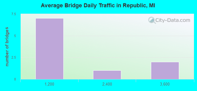
- 10,088Total average daily traffic
- 1,147Total average daily truck traffic
- 11,354Total future (year 2018) average daily traffic
- National Bridge Inventory (NBI) Registered Bridges for Republic
- No street view available for this location
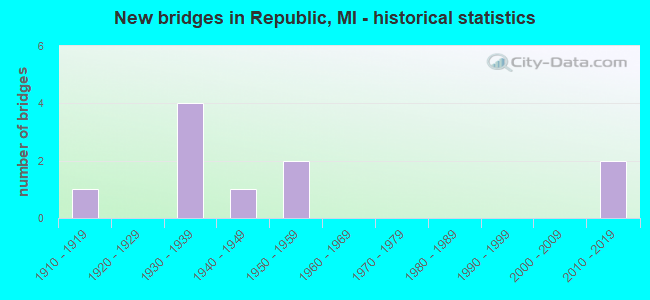
- New bridges - historical statistics
- 11910-1919
- 41930-1939
- 11940-1949
- 21950-1959
- 22010-2019
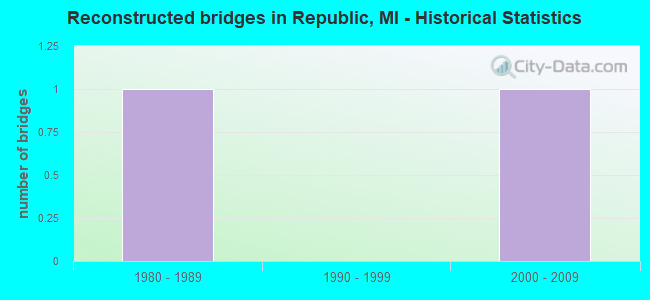
- Reconstructed bridges - Historical Statistics
- 11980-1989
- 01990-1999
- 12000-2009
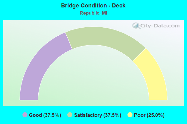
- Bridge Condition - Deck
- 37.5%Good
- 37.5%Satisfactory
- 25.0%Poor
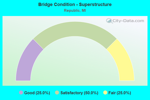
- Bridge Condition - Superstructure
- 25.0%Good
- 50.0%Satisfactory
- 25.0%Fair
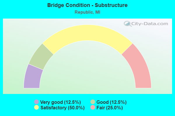
- Bridge Condition - Substructure
- 12.5%Very good
- 12.5%Good
- 50.0%Satisfactory
- 25.0%Fair
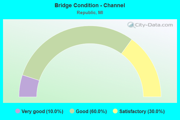
- Bridge Condition - Channel
- 10.0%Very good
- 60.0%Good
- 30.0%Satisfactory
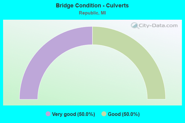
- Bridge Condition - Culverts
- 50.0%Very good
- 50.0%Good
Find on map >> Show street view
Structure Number: 6472, Location: 9.8 MI S OF US-41 (Lat: 46.374842, Lng: -87.991264), Route carried "on" structure: State highway 95, Year Built: 1958, Status: Open, Structure Length: 3.93m (12.89ft), Average Daily Traffic: 3,375 (year 2019), Truck Traffic: 11%, Average Future Daily Traffic: 3,725 (year 2039), Design Load: HS 20, Features Intersected: TROUT FALLS CREEK
Minimum Vertical Clearance: 30.48m (100.00ft), Kilometerpoint: 16.105, Lanes on structure: 2, Base Highway Network: Yes (Inventory Route: 156, Subroute: 10), Owner: State Highway Agency, Approaching Roadway Width: 11.6m (38.1ft), Skew: 1 degrees, Material/Design: Steel, Design/Construction: Stringer/Multi-beam, Number Of Spans In Main Unit: 3, Length of Maximum Span: 13.1m (43.0ft), Curb-To-Curb Width: 9.1m (29.9ft), Out-to-Out Width: 10.8m (35.4ft)
Condition: Deck: Satisfactory, Superstructure: Satisfactory, Substructure: Satisfactory, Channel: Good, Operating Rating: 64.2 metric tons, Method Used To Determine Operating Rating: Load Factor (LF) rating reported by rating factor (RF) method using MS18 loading, Inventory Rating: 38.2 metric tons, Method Used To Determine Inventory Rating: Load Factor (LF) rating reported by rating factor (RF) method using MS18 loading, Structural Evaluation: Equal to present minimum criteria, Deck Geometry: Meets minimum limits, Waterway Adequacy: Better than present minimum criteria, Approach Roadway Alignment: Better than present minimum criteria, Designated Inspection Frequency: Every 24 months, Inspection Date: June 2021, Deck Structure Type: Concrete Cast-file-Place, Wearing Surface/Protective System: Wearing Surface: Latex Concrete
Find on map >> Show street view
Structure Number: 6473, Location: 6.9 MI S OF US-41 (Lat: 46.413353, Lng: -87.993531), Route carried "on" structure: State highway 95, Year Built: 1958, Status: Open, Structure Length: 7.92m (25.98ft), Average Daily Traffic: 3,375 (year 2019), Truck Traffic: 11%, Average Future Daily Traffic: 3,725 (year 2039), Design Load: HS 20, Features Intersected: MICHIGAMME RIVER
Minimum Vertical Clearance: 30.48m (100.00ft), Kilometerpoint: 20.512, Lanes on structure: 2, Base Highway Network: Yes (Inventory Route: 156, Subroute: 10), Owner: State Highway Agency, Approaching Roadway Width: 12.2m (40.0ft), Skew: 2 degrees, Material/Design: Steel, Design/Construction: Stringer/Multi-beam, Number Of Spans In Main Unit: 4, Length of Maximum Span: 19.8m (65.0ft), Curb-To-Curb Width: 9.1m (29.9ft), Out-to-Out Width: 11.4m (37.4ft)
Condition: Deck: Satisfactory, Superstructure: Satisfactory, Substructure: Satisfactory, Channel: Good, Operating Rating: 67.4 metric tons, Method Used To Determine Operating Rating: Load Factor (LF) rating reported by rating factor (RF) method using MS18 loading, Inventory Rating: 40.2 metric tons, Method Used To Determine Inventory Rating: Load Factor (LF) rating reported by rating factor (RF) method using MS18 loading, Structural Evaluation: Equal to present minimum criteria, Deck Geometry: Meets minimum limits, Waterway Adequacy: Equal to present desirable criteria, Approach Roadway Alignment: Better than present minimum criteria, Designated Inspection Frequency: Every 24 months, Inspection Date: June 2021, Deck Structure Type: Concrete Cast-file-Place, Wearing Surface/Protective System: Wearing Surface: Latex Concrete
Find on map >> Show street view
Structure Number: 6474, Location: 3.2 MI S OF US-41 (Lat: 46.451333, Lng: -87.950703), Route carried "on" structure: State highway 95, Year Built: 1942, Status: Open, Structure Length: 1.18m (3.87ft), Average Daily Traffic: 2,378 (year 2007), Truck Traffic: 17%, Average Future Daily Traffic: 2,771 (year 2018), Design Load: H 20, Features Intersected: BLACK RIVER
Minimum Vertical Clearance: 30.48m (100.00ft), Kilometerpoint: 26.000, Lanes on structure: 2, Base Highway Network: Yes (Inventory Route: 156, Subroute: 10), Owner: State Highway Agency, Approaching Roadway Width: 11.6m (38.1ft), Material/Design: Concrete, Design/Construction: Tee Beam, Number Of Spans In Main Unit: 1, Length of Maximum Span: 11.8m (38.7ft), Curb-To-Curb Width: 11.0m (36.1ft), Out-to-Out Width: 14.6m (47.9ft)
Condition: Deck: Good, Superstructure: Satisfactory, Substructure: Satisfactory, Channel: Good, Operating Rating: 59.3 metric tons, Method Used To Determine Operating Rating: Load Factor (LF) rating reported by rating factor (RF) method using MS18 loading, Inventory Rating: 36.0 metric tons, Method Used To Determine Inventory Rating: Load Factor (LF) rating reported by rating factor (RF) method using MS18 loading, Structural Evaluation: Equal to present minimum criteria, Deck Geometry: Somewhat better than minimum adequacy, Waterway Adequacy: Equal to present minimum criteria, Approach Roadway Alignment: Better than present minimum criteria, Designated Inspection Frequency: Every 24 months, Inspection Date: June 2021, Deck Structure Type: Concrete Cast-file-Place, Wearing Surface/Protective System: Wearing Surface: Bituminous
Find on map >> Show street view
Structure Number: 653, Location: IN REPUBLIC (Lat: 46.406342, Lng: -87.981922), Route carried "on" structure: County highway 5211, Year Built: 1911, Year Reconstructed: 1985, Status: Open, Structure Length: 4.48m (14.70ft), Average Daily Traffic: 527 (year 2001), Average Future Daily Traffic: 600 (year 2020), Design Load: HS 20+Mod, Features Intersected: MICHIGAMME RIVER, Facility Carried by Structure: COUNTY RD 601
Minimum Vertical Clearance: 30.48m (100.00ft), Kilometerpoint: 13.187, Lanes on structure: 2, Owner: County Highway Agency, Approaching Roadway Width: 7.3m (24.0ft), Material/Design: Prestressed concrete, Design/Construction: Box Beam or Girders - Multiple, Number Of Spans In Main Unit: 2, Length of Maximum Span: 21.9m (71.9ft), Curb-To-Curb Width: 10.3m (33.8ft), Out-to-Out Width: 10.4m (34.1ft)
Condition: Deck: Satisfactory, Superstructure: Satisfactory, Substructure: Good, Channel: Good, Operating Rating: 39.5 metric tons, Method Used To Determine Operating Rating: Load and Resistance Factor Rating (LRFR) rating reported by rating factor(RF) method using HL-93 loadings, Inventory Rating: 30.5 metric tons, Method Used To Determine Inventory Rating: Load and Resistance Factor Rating (LRFR) rating reported by rating factor(RF) method using HL-93 loadings, Structural Evaluation: Equal to present minimum criteria, Deck Geometry: Equal to present minimum criteria, Waterway Adequacy: Equal to present desirable criteria, Approach Roadway Alignment: Equal to present desirable criteria, Designated Inspection Frequency: Every 24 months, Inspection Date: October 2020, Deck Structure Type: Concrete Cast-file-Place, Wearing Surface/Protective System: Wearing Surface: Bituminous, Deck Protection: Epoxy Coated Reinforcing
Find on map >> Show street view
Structure Number: 6543, Location: 3 MILES N E OF REPUBLIC (Lat: 46.425953, Lng: -87.927967), Route carried "on" structure: County highway 5260, Year Built: 2019, Status: Open, Structure Length: 1.43m (4.69ft), Average Daily Traffic: 44 (year 2019), Truck Traffic: 4%, Average Future Daily Traffic: 68 (year 2039), Design Load: Greater than HL93, Features Intersected: BLACK RIVER, Facility Carried by Structure: COUNTY RD 478
Minimum Vertical Clearance: 30.48m (100.00ft), Kilometerpoint: 2.173, Lanes on structure: 2, Owner: County Highway Agency, Approaching Roadway Width: 8.5m (27.9ft), Material/Design: Concrete, Design/Construction: Culvert, Number Of Spans In Main Unit: 1, Length of Maximum Span: 14.3m (46.9ft), Curb-To-Curb Width: 8.6m (28.2ft), Out-to-Out Width: 9.6m (31.5ft)
Condition: Channel: Very good, Culverts: Very good, Operating Rating: 96.6 metric tons, Method Used To Determine Operating Rating: Load and Resistance Factor Rating (LRFR) rating reported by rating factor(RF) method using HL-93 loadings, Inventory Rating: 71.3 metric tons, Method Used To Determine Inventory Rating: Load and Resistance Factor Rating (LRFR) rating reported by rating factor(RF) method using HL-93 loadings, Structural Evaluation: Equal to present desirable criteria, Deck Geometry: Better than present minimum criteria, Waterway Adequacy: Equal to present desirable criteria, Approach Roadway Alignment: Equal to present minimum criteria, Length Of Structure Improvement: 1.34m (4.40ft), Designated Inspection Frequency: Every 24 months, Inspection Date: October 2021, Bridge Improvement Cost: $95,000, Roadway Improvement Cost: $10,000, Total Project Cost: $112,000, Wearing Surface/Protective System: Wearing Surface: Bituminous
Find on map >> Show street view
Structure Number: 6603, Location: 2 MI S OF REPUBLIC (Lat: 46.377194, Lng: -87.986686), Route carried "on" structure: County highway , Year Built: 1938, Status: Open, Structure Length: 1.03m (3.38ft), Average Daily Traffic: 140 (year 2001), Average Future Daily Traffic: 160 (year 2020), Design Load: HS 20+Mod, Features Intersected: TROUT FALLS CREEK, Facility Carried by Structure: LE ROAD
Minimum Vertical Clearance: 30.48m (100.00ft), Kilometerpoint: 1.728, Lanes on structure: 2, Owner: County Highway Agency, Approaching Roadway Width: 8.5m (27.9ft), Material/Design: Steel, Design/Construction: Stringer/Multi-beam, Number Of Spans In Main Unit: 1, Length of Maximum Span: 9.4m (30.8ft), Curb-To-Curb Width: 7.0m (23.0ft), Out-to-Out Width: 7.8m (25.6ft)
Condition: Deck: Poor, Superstructure: Fair, Substructure: Satisfactory, Channel: Satisfactory, Operating Rating: 97.2 metric tons, Method Used To Determine Operating Rating: Load Factor (LF) rating reported by rating factor (RF) method using MS18 loading, Inventory Rating: 69.3 metric tons, Method Used To Determine Inventory Rating: Load Factor (LF) rating reported by rating factor (RF) method using MS18 loading, Structural Evaluation: Somewhat better than minimum adequacy, Deck Geometry: Meets minimum limits, Waterway Adequacy: Equal to present desirable criteria, Approach Roadway Alignment: Equal to present desirable criteria, Designated Inspection Frequency: Every 24 months, Inspection Date: October 2021, Deck Structure Type: Concrete Cast-file-Place, Wearing Surface/Protective System: Wearing Surface: Bituminous
Find on map >> Show street view
Structure Number: 6604, Location: 0.5 MI SE OF SO REPUBLIC (Lat: 46.358708, Lng: -87.975778), Route carried "on" structure: County highway , Year Built: 1930, Year Reconstructed: 2005, Status: Open, Structure Length: 3.04m (9.97ft), Average Daily Traffic: 126 (year 2000), Average Future Daily Traffic: 150 (year 2020), Design Load: HS 20+Mod, Features Intersected: MICHIGAMME RIVER, Facility Carried by Structure: LI ROAD
Minimum Vertical Clearance: 30.48m (100.00ft), Kilometerpoint: 1.519, Lanes on structure: 2, Owner: County Highway Agency, Approaching Roadway Width: 5.5m (18.0ft), Material/Design: Steel, Design/Construction: Stringer/Multi-beam, Number Of Spans In Main Unit: 2, Length of Maximum Span: 14.6m (47.9ft), Curb-To-Curb Width: 4.9m (16.1ft), Out-to-Out Width: 4.9m (16.1ft)
Condition: Deck: Good, Superstructure: Good, Substructure: Fair, Channel: Good, Operating Rating: 42.0 metric tons, Method Used To Determine Operating Rating: Load Factor (LF), Inventory Rating: 31.0 metric tons, Method Used To Determine Inventory Rating: Load Factor (LF), Structural Evaluation: Somewhat better than minimum adequacy, Deck Geometry: High priority of replacement, Waterway Adequacy: Equal to present desirable criteria, Approach Roadway Alignment: Meets minimum limits, Length Of Structure Improvement: 3.05m (10.01ft), Designated Inspection Frequency: Every 24 months, Inspection Date: October 2021, Bridge Improvement Cost: $386,000, Roadway Improvement Cost: $140,000, Total Project Cost: $526,000, Deck Structure Type: Wood or Timber, Wearing Surface/Protective System: Wearing Surface: Wood or Timber
Find on map >> Show street view
Structure Number: 6605, Location: 1.4 MI N OF SO REPUBLIC (Lat: 46.383200, Lng: -87.978711), Route carried "on" structure: County highway , Year Built: 1934, Status: Open, Structure Length: 4.57m (14.99ft), Average Daily Traffic: 10 (year 2001), Average Future Daily Traffic: 10 (year 2020), Design Load: HS 20+Mod, Features Intersected: MICHIGAMME RIVER, Facility Carried by Structure: LLL ROAD (OLD M95)
Minimum Vertical Clearance: 30.48m (100.00ft), Kilometerpoint: 3.663, Lanes on structure: 2, Owner: County Highway Agency, Approaching Roadway Width: 11.0m (36.1ft), Material/Design: Steel, Design/Construction: Stringer/Multi-beam, Number Of Spans In Main Unit: 3, Length of Maximum Span: 14.6m (47.9ft), Curb or Sidewalk Widths: Left: 0.4m (1.3ft), Right: 0.4m (1.3ft), Curb-To-Curb Width: 7.9m (25.9ft), Out-to-Out Width: 9.4m (30.8ft)
Condition: Deck: Poor, Superstructure: Fair, Substructure: Fair, Channel: Satisfactory, Operating Rating: 54.8 metric tons, Method Used To Determine Operating Rating: Load Factor (LF) rating reported by rating factor (RF) method using MS18 loading, Inventory Rating: 28.5 metric tons, Method Used To Determine Inventory Rating: Load Factor (LF) rating reported by rating factor (RF) method using MS18 loading, Structural Evaluation: Somewhat better than minimum adequacy, Deck Geometry: Equal to present minimum criteria, Waterway Adequacy: Equal to present desirable criteria, Approach Roadway Alignment: Better than present minimum criteria, Designated Inspection Frequency: Every 24 months, Inspection Date: October 2021, Deck Structure Type: Concrete Cast-file-Place, Wearing Surface/Protective System: Wearing Surface: Bituminous
Find on map >> Show street view
Structure Number: 6606, Location: 1.3 MI N OF SO REPUBLIC (Lat: 46.381692, Lng: -87.978511), Route carried "on" structure: County highway , Year Built: 1935, Status: Open, Structure Length: 0.94m (3.08ft), Average Daily Traffic: 30 (year 1994), Average Future Daily Traffic: 50 (year 2020), Design Load: HS 20+Mod, Features Intersected: TROUT FALLS CREEK, Facility Carried by Structure: LLL ROAD
Minimum Vertical Clearance: 30.48m (100.00ft), Kilometerpoint: 3.452, Lanes on structure: 2, Owner: County Highway Agency, Approaching Roadway Width: 8.5m (27.9ft), Material/Design: Concrete, Design/Construction: Culvert, Number Of Spans In Main Unit: 1, Length of Maximum Span: 8.5m (27.9ft), Curb-To-Curb Width: 8.5m (27.9ft), Out-to-Out Width: 14.7m (48.2ft)
Condition: Channel: Satisfactory, Culverts: Good, Operating Rating: 47.6 metric tons, Method Used To Determine Operating Rating: Load Factor (LF), Inventory Rating: 18.2 metric tons, Method Used To Determine Inventory Rating: Load Factor (LF), Structural Evaluation: Somewhat better than minimum adequacy, Deck Geometry: Better than present minimum criteria, Waterway Adequacy: Equal to present desirable criteria, Approach Roadway Alignment: Equal to present desirable criteria, Designated Inspection Frequency: Every 24 months, Inspection Date: October 2021, Deck Structure Type: Concrete Cast-file-Place, Wearing Surface/Protective System: Wearing Surface: Bituminous
Find on map >> Show street view
Structure Number: 14291, Location: 0.75 MI N OF CR 478 (Lat: 46.443650, Lng: -87.935650), Route carried "on" structure: County highway 5211, Year Built: 2018, Status: Open, Structure Length: 1.04m (3.41ft), Average Daily Traffic: 83 (year 2016), Average Future Daily Traffic: 95 (year 2036), Design Load: Greater than HL93, Features Intersected: BLACK RIVER, Facility Carried by Structure: CR 601
Minimum Vertical Clearance: 30.48m (100.00ft), Kilometerpoint: 0.000, Lanes on structure: 1, Owner: County Highway Agency, Approaching Roadway Width: 6.1m (20.0ft), Material/Design: Steel, Design/Construction: Stringer/Multi-beam, Number Of Spans In Main Unit: 1, Length of Maximum Span: 7.7m (25.3ft), Curb-To-Curb Width: 4.1m (13.5ft), Out-to-Out Width: 4.2m (13.8ft)
Condition: Deck: Good, Superstructure: Good, Substructure: Very good, Channel: Good, Operating Rating: 97.2 metric tons, Method Used To Determine Operating Rating: Load and Resistance Factor Rating (LRFR) rating reported by rating factor(RF) method using HL-93 loadings, Inventory Rating: 97.2 metric tons, Method Used To Determine Inventory Rating: Load and Resistance Factor Rating (LRFR) rating reported by rating factor(RF) method using HL-93 loadings, Structural Evaluation: Better than present minimum criteria, Deck Geometry: Somewhat better than minimum adequacy, Waterway Adequacy: Equal to present desirable criteria, Approach Roadway Alignment: Equal to present minimum criteria, Designated Inspection Frequency: Every 24 months, Inspection Date: July 2020, Deck Structure Type: Open Grating