Bridge Statistics for Rhome, Texas (TX)
Condition, Traffic, Stress, Structural Evaluation, Project Costs
- National Bridge Inventory (NBI) Statistics
- 16Number of bridges
- 207ft / 62.9mTotal length
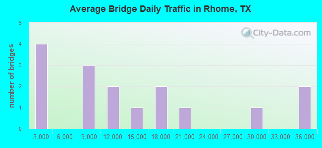
- 206,503Total average daily traffic
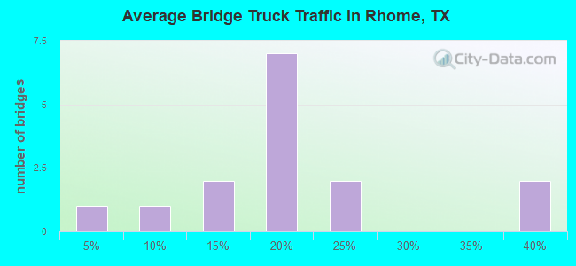
- 43,576Total average daily truck traffic
- National Bridge Inventory (NBI) Registered Bridges for Rhome
- No street view available for this location
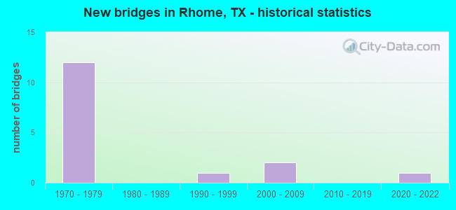
- New bridges - historical statistics
- 121970-1979
- 11990-1999
- 22000-2009
- 12020-2022
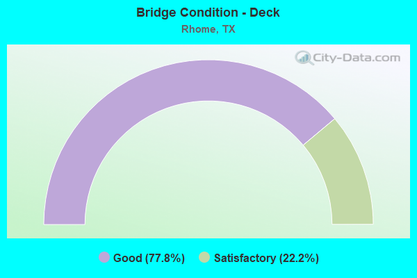
- Bridge Condition - Deck
- 77.8%Good
- 22.2%Satisfactory
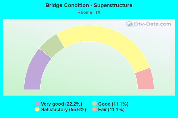
- Bridge Condition - Superstructure
- 22.2%Very good
- 11.1%Good
- 55.6%Satisfactory
- 11.1%Fair
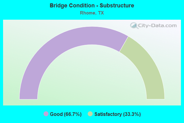
- Bridge Condition - Substructure
- 66.7%Good
- 33.3%Satisfactory
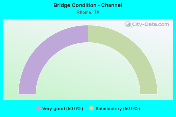
- Bridge Condition - Channel
- 50.0%Very good
- 50.0%Satisfactory
Find on map >> Show street view
Structure Number: 22490001308052, Location: 1.0 MI N OF SH 114 (Lat: 33.069972, Lng: -97.473722), Route carried "on" structure: County highway 274, Year Built: 1972, Status: Open, Structure Length: 5.79m (19.00ft), Average Daily Traffic: 386 (year 2019), Truck Traffic: 16%, Average Future Daily Traffic: 850 (year 2031), Design Load: H 20, Features Intersected: US 81/287
Minimum Vertical Clearance: 30+ m (98+ ft), Kilometerpoint: 48.296, Lanes on structure: 2, Lanes under structure: 4, Owner: State Highway Agency, Approaching Roadway Width: 13.4m (44.0ft), Material/Design: Prestressed concrete, Design/Construction: Stringer/Multi-beam, Number Of Spans In Main Unit: 2, Length of Maximum Span: 28.7m (94.2ft), Curb-To-Curb Width: 13.4m (44.0ft), Out-to-Out Width: 14.1m (46.3ft)
Condition: Deck: Good, Superstructure: Fair, Substructure: Good, Operating Rating: 68.0 metric tons, Method Used To Determine Operating Rating: Load Factor (LF), Inventory Rating: 24.5 metric tons, Method Used To Determine Inventory Rating: Load Factor (LF), Structural Evaluation: Somewhat better than minimum adequacy, Deck Geometry: Superior to present desirable criteria, Underclear: Better than present minimum criteria, Approach Roadway Alignment: Equal to present desirable criteria, Designated Inspection Frequency: Every 24 months, Inspection Date: Febuary 2021, Deck Structure Type: Concrete Cast-file-Place, Wearing Surface/Protective System: Membrane: Other, Deck Protection: Other
Find on map >> Show street view
Structure Number: 22490001308053, Location: AT JCT SH-114 ON US-81 (Lat: 33.055767, Lng: -97.478639), Route carried "on" structure: State highway 114, Year Built: 1972, Status: Open, Structure Length: 7.62m (25.00ft), Average Daily Traffic: 13,793 (year 2020), Truck Traffic: 17%, Average Future Daily Traffic: 14,490 (year 2033), Design Load: HS 20, Features Intersected: US 81/287
Minimum Vertical Clearance: 30+ m (98+ ft), Kilometerpoint: 61.561, Lanes on structure: 2, Lanes under structure: 4, Base Highway Network: Yes, Owner: State Highway Agency, Approaching Roadway Width: 13.4m (44.0ft), Skew: 1 degrees, Material/Design: Prestressed concrete, Design/Construction: Stringer/Multi-beam, Number Of Spans In Main Unit: 2, Number Of Approach Spans: 2, Length of Maximum Span: 25.3m (83.0ft), Curb-To-Curb Width: 13.4m (44.0ft), Out-to-Out Width: 14.1m (46.3ft)
Condition: Deck: Good, Superstructure: Satisfactory, Substructure: Satisfactory, Operating Rating: 65.3 metric tons, Method Used To Determine Operating Rating: Load Factor (LF), Inventory Rating: 29.9 metric tons, Method Used To Determine Inventory Rating: Load Factor (LF), Structural Evaluation: Equal to present minimum criteria, Deck Geometry: Equal to present minimum criteria, Underclear: Better than present minimum criteria, Approach Roadway Alignment: Equal to present desirable criteria, Designated Inspection Frequency: Every 24 months, Inspection Date: Febuary 2021, Deck Structure Type: Concrete Cast-file-Place, Wearing Surface/Protective System: Wearing Surface: Bituminous, Membrane: Other, Deck Protection: Other
Find on map >> Show street view
Structure Number: 22490001308054, Location: AT JCT US-81 & US-287 (Lat: 33.046333, Lng: -97.471622), Route carried "on" structure: ServiceState highway 81, Year Built: 1972, Status: Open, Structure Length: 9.51m (31.20ft), Average Daily Traffic: 2,797 (year 2020), Truck Traffic: 9%, Average Future Daily Traffic: 5,740 (year 2033), Design Load: H 20, Features Intersected: US 81
Minimum Vertical Clearance: 30+ m (98+ ft), Kilometerpoint: 51.000, Lanes on structure: 2, Lanes under structure: 5, Owner: State Highway Agency, Approaching Roadway Width: 13.4m (44.0ft), Skew: 1 degrees, Material/Design: Prestressed concrete, Design/Construction: Stringer/Multi-beam, Number Of Spans In Main Unit: 3, Number Of Approach Spans: 2, Length of Maximum Span: 25.3m (83.0ft), Curb-To-Curb Width: 13.4m (44.0ft), Out-to-Out Width: 14.1m (46.3ft)
Condition: Deck: Good, Superstructure: Satisfactory, Substructure: Satisfactory, Operating Rating: 66.2 metric tons, Method Used To Determine Operating Rating: Load Factor (LF), Inventory Rating: 25.4 metric tons, Method Used To Determine Inventory Rating: Load Factor (LF), Structural Evaluation: Equal to present minimum criteria, Deck Geometry: Better than present minimum criteria, Underclear: Somewhat better than minimum adequacy, Approach Roadway Alignment: Equal to present desirable criteria, Designated Inspection Frequency: Every 24 months, Inspection Date: Febuary 2021, Deck Structure Type: Concrete Cast-file-Place, Wearing Surface/Protective System: Membrane: Other, Deck Protection: Other
Find on map >> Show street view
Structure Number: 224900013081, Location: 1.25 MI S OF SH 114/B114 (Lat: 33.044786, Lng: -97.464758), Route carried "on" structure: State highway 114, Year Built: 1972, Status: Open, Structure Length: 12.80m (41.99ft), Average Daily Traffic: 7,640 (year 2013), Truck Traffic: 15%, Average Future Daily Traffic: 10,700 (year 2033), Design Load: HS 20, Features Intersected: US 81
Minimum Vertical Clearance: 30+ m (98+ ft), Kilometerpoint: 0.887, Lanes on structure: 2, Lanes under structure: 4, Base Highway Network: Yes, Owner: State Highway Agency, Approaching Roadway Width: 12.2m (40.0ft), Skew: 5 degrees, Material/Design: Steel continuous, Design/Construction: Stringer/Multi-beam, Number Of Spans In Main Unit: 2, Number Of Approach Spans: 2, Length of Maximum Span: 41.1m (134.8ft), Curb-To-Curb Width: 12.7m (41.7ft), Out-to-Out Width: 13.4m (44.0ft)
Condition: Deck: Satisfactory, Superstructure: Satisfactory, Substructure: Good, Operating Rating: 68.0 metric tons, Method Used To Determine Operating Rating: Load Factor (LF), Inventory Rating: 40.8 metric tons, Method Used To Determine Inventory Rating: Load Factor (LF), Structural Evaluation: Equal to present minimum criteria, Deck Geometry: Better than present minimum criteria, Underclear: Superior to present desirable criteria, Approach Roadway Alignment: Equal to present desirable criteria, Designated Inspection Frequency: Every 24 months, Inspection Date: Febuary 2021, Deck Structure Type: Concrete Cast-file-Place, Wearing Surface/Protective System: Wearing Surface: Bituminous, Membrane: Other, Deck Protection: Other
Find on map >> Show street view
Structure Number: 22490035301101, Location: 0.4 MI E OF LOOP 506 (Lat: 33.045936, Lng: -97.461964), Route carried "on" structure: State highway 114, Year Built: 1972, Status: Open, Structure Length: 7.62m (25.00ft), Average Daily Traffic: 7,640 (year 2013), Truck Traffic: 15%, Average Future Daily Traffic: 10,700 (year 2033), Design Load: HS 20, Features Intersected: BNSF RR & RAMP O
Minimum Vertical Clearance: 30+ m (98+ ft), Kilometerpoint: 1.175, Lanes on structure: 3, Lanes under structure: 2, Base Highway Network: Yes, Owner: State Highway Agency, Approaching Roadway Width: 15.2m (49.9ft), Skew: 3 degrees, Material/Design: Prestressed concrete, Design/Construction: Stringer/Multi-beam, Number Of Spans In Main Unit: 4, Length of Maximum Span: 18.9m (62.0ft), Curb-To-Curb Width: 15.2m (49.9ft), Out-to-Out Width: 15.9m (52.2ft)
Condition: Deck: Satisfactory, Superstructure: Satisfactory, Substructure: Good, Operating Rating: 68.0 metric tons, Method Used To Determine Operating Rating: Load Factor (LF), Inventory Rating: 37.2 metric tons, Method Used To Determine Inventory Rating: Load Factor (LF), Structural Evaluation: Equal to present minimum criteria, Deck Geometry: Equal to present minimum criteria, Underclear: Somewhat better than minimum adequacy, Approach Roadway Alignment: Equal to present desirable criteria, Designated Inspection Frequency: Every 24 months, Inspection Date: March 2021, Deck Structure Type: Concrete Cast-file-Place, Wearing Surface/Protective System: Membrane: Other, Deck Protection: Other
Find on map >> Show street view
Structure Number: 22490035301102, Location: 0.730 MI FROM BEB OF SEC (Lat: 33.045611, Lng: -97.461500), Route carried "on" structure: State highway 114, Year Built: 1972, Status: Open, Structure Length: 7.62m (25.00ft), Average Daily Traffic: 7,640 (year 2013), Truck Traffic: 15%, Average Future Daily Traffic: 10,700 (year 2033), Design Load: HS 20, Features Intersected: BNSF RR & RAMP O
Minimum Vertical Clearance: 30+ m (98+ ft), Kilometerpoint: 1.175, Lanes on structure: 2, Lanes under structure: 2, Base Highway Network: Yes, Owner: State Highway Agency, Approaching Roadway Width: 12.8m (42.0ft), Skew: 3 degrees, Material/Design: Prestressed concrete, Design/Construction: Stringer/Multi-beam, Number Of Spans In Main Unit: 4, Length of Maximum Span: 18.9m (62.0ft), Curb-To-Curb Width: 12.7m (41.7ft), Out-to-Out Width: 13.4m (44.0ft)
Condition: Deck: Good, Superstructure: Satisfactory, Substructure: Good, Operating Rating: 68.0 metric tons, Method Used To Determine Operating Rating: Load Factor (LF), Inventory Rating: 38.1 metric tons, Method Used To Determine Inventory Rating: Load Factor (LF), Structural Evaluation: Equal to present minimum criteria, Deck Geometry: Better than present minimum criteria, Underclear: Equal to present minimum criteria, Approach Roadway Alignment: Equal to present desirable criteria, Designated Inspection Frequency: Every 24 months, Inspection Date: March 2021, Deck Structure Type: Concrete Cast-file-Place, Wearing Surface/Protective System: Membrane: Other, Deck Protection: Other
Find on map >> Show street view
Structure Number: 22490035301206, Location: .6 MI W OF DENTON CO LINE (Lat: 33.036942, Lng: -97.405258), Route carried "on" structure: State highway 114, Year Built: 2007, Status: Open, Structure Length: 4.79m (15.72ft), Average Daily Traffic: 9,024 (year 2020), Truck Traffic: 14%, Average Future Daily Traffic: 9,870 (year 2033), Design Load: HS 20, Features Intersected: ELIZABETH CREEK
Minimum Vertical Clearance: 30+ m (98+ ft), Kilometerpoint: 6.764, Lanes on structure: 2, Base Highway Network: Yes, Owner: State Highway Agency, Approaching Roadway Width: 11.6m (38.1ft), Skew: 3 degrees, Material/Design: Prestressed concrete, Design/Construction: Stringer/Multi-beam, Number Of Spans In Main Unit: 1, Number Of Approach Spans: 2, Length of Maximum Span: 24.1m (79.1ft), Curb-To-Curb Width: 11.4m (37.4ft), Out-to-Out Width: 12.0m (39.4ft)
Condition: Deck: Good, Superstructure: Very good, Substructure: Good, Channel: Very good, Operating Rating: 54.4 metric tons, Method Used To Determine Operating Rating: Assigned rating based on Load Factor Design (LFD) reported in metric tons, Inventory Rating: 32.7 metric tons, Method Used To Determine Inventory Rating: Assigned rating based on Load Factor Design (LFD) reported in metric tons, Structural Evaluation: Better than present minimum criteria, Deck Geometry: Equal to present minimum criteria, Waterway Adequacy: Superior to present desirable criteria, Approach Roadway Alignment: Equal to present desirable criteria, Designated Inspection Frequency: Every 24 months, Inspection Date: March 2021, Deck Structure Type: Concrete Cast-file-Place, Wearing Surface/Protective System: Membrane: Other, Deck Protection: Epoxy Coated Reinforcing
Find on map >> Show street view
Structure Number: 22490035301207, Location: .6 MI W OF DENTON CO LINE (Lat: 33.036639, Lng: -97.405336), Route carried "on" structure: State highway 114, Year Built: 2005, Status: Open, Structure Length: 4.79m (15.72ft), Average Daily Traffic: 9,310 (year 2020), Truck Traffic: 14%, Average Future Daily Traffic: 9,870 (year 2033), Design Load: HS 20, Features Intersected: ELIZABETH CREEK
Minimum Vertical Clearance: 30+ m (98+ ft), Kilometerpoint: 6.787, Lanes on structure: 2, Base Highway Network: Yes, Owner: State Highway Agency, Approaching Roadway Width: 11.6m (38.1ft), Skew: 3 degrees, Material/Design: Prestressed concrete, Design/Construction: Stringer/Multi-beam, Number Of Spans In Main Unit: 1, Number Of Approach Spans: 2, Length of Maximum Span: 24.1m (79.1ft), Curb-To-Curb Width: 11.4m (37.4ft), Out-to-Out Width: 12.0m (39.4ft)
Condition: Deck: Good, Superstructure: Very good, Substructure: Good, Channel: Very good, Operating Rating: 54.4 metric tons, Method Used To Determine Operating Rating: Assigned rating based on Load Factor Design (LFD) reported in metric tons, Inventory Rating: 32.7 metric tons, Method Used To Determine Inventory Rating: Assigned rating based on Load Factor Design (LFD) reported in metric tons, Structural Evaluation: Better than present minimum criteria, Deck Geometry: Equal to present minimum criteria, Waterway Adequacy: Superior to present desirable criteria, Approach Roadway Alignment: Equal to present desirable criteria, Designated Inspection Frequency: Every 24 months, Inspection Date: March 2021, Deck Structure Type: Concrete Cast-file-Place, Wearing Surface/Protective System: Membrane: Other, Deck Protection: Epoxy Coated Reinforcing
Find on map >> Show street view
Structure Number: 22490AA0272001, Location: 2.2 MI E OF BU 81 (Lat: 33.065542, Lng: -97.438794), Route carried "on" structure: County highway 4733, Year Built: 1997, Status: Open, Structure Length: 1.22m (4.00ft), Average Daily Traffic: 403 (year 2014), Average Future Daily Traffic: 443 (year 2034), Features Intersected: ELIZABETH CREEK
Minimum Vertical Clearance: 30+ m (98+ ft), Kilometerpoint: 3.541, Lanes on structure: 2, Owner: County Highway Agency, Approaching Roadway Width: 6.7m (22.0ft), Material/Design: Steel, Design/Construction: Stringer/Multi-beam, Number Of Spans In Main Unit: 1, Length of Maximum Span: 11.9m (39.0ft), Curb-To-Curb Width: 7.2m (23.6ft), Out-to-Out Width: 7.3m (24.0ft)
Condition: Deck: Good, Superstructure: Good, Substructure: Satisfactory, Channel: Satisfactory, Operating Rating: 32.7 metric tons, Method Used To Determine Operating Rating: Field evaluation and documented engineering judgment, Inventory Rating: 24.5 metric tons, Method Used To Determine Inventory Rating: Field evaluation and documented engineering judgment, Structural Evaluation: Equal to present minimum criteria, Deck Geometry: Meets minimum limits, Waterway Adequacy: Equal to present desirable criteria, Approach Roadway Alignment: Equal to present desirable criteria, Designated Inspection Frequency: Every 24 months, Inspection Date: January 2020, Deck Structure Type: Concrete Cast-file-Place, Wearing Surface/Protective System: Wearing Surface: Bituminous
Find on map >> Show street view
Structure Number: 180610AA0548002, Location: 0.25 Mi N of SH 114 (Lat: 33.040603, Lng: -97.391711), Route carried "on" structure: County highway , Year Built: 2020, Status: Open, Structure Length: 1.13m (3.71ft), Average Daily Traffic: 800 (year 2018), Truck Traffic: 3%, Average Future Daily Traffic: 1,200 (year 2038), Design Load: HL 93, Features Intersected: Trib Elizabeth Creek, Facility Carried by Structure: S County Line Rd
Minimum Vertical Clearance: 30+ m (98+ ft), Kilometerpoint: 0.402, Lanes on structure: 2, Owner: County Highway Agency, Approaching Roadway Width: 7.9m (25.9ft), Skew: 3 degrees, Material/Design: Concrete, Design/Construction: Culvert, Number Of Spans In Main Unit: 3, Length of Maximum Span: 2.7m (8.9ft), Curb-To-Curb Width: 7.9m (25.9ft), Out-to-Out Width: 11.4m (37.4ft)
Condition: Channel: Satisfactory, Culverts: Good, Operating Rating: 54.4 metric tons, Method Used To Determine Operating Rating: Assigned ratings based on Load and Resistance Factor Design (LRFD) reported in metric tons, Inventory Rating: 32.7 metric tons, Method Used To Determine Inventory Rating: Assigned ratings based on Load and Resistance Factor Design (LRFD) reported in metric tons, Structural Evaluation: Better than present minimum criteria, Deck Geometry: Somewhat better than minimum adequacy, Waterway Adequacy: Superior to present desirable criteria, Approach Roadway Alignment: Equal to present desirable criteria, Designated Inspection Frequency: Every 24 months, Inspection Date: August 2020, Deck Structure Type: Concrete Precast Panels, Wearing Surface/Protective System: Wearing Surface: Monolithic Concrete
Find on map >> Show street view
Structure Number: 22490001308052, Location: 1.0 MI N OF SH 114 (Lat: 33.069972, Lng: -97.473722), Route carried "under" structure: US 81, Year Built: 1972, Structure Length: 0. m, Average Daily Traffic: 27,800 (year 2013), Truck Traffic: 35%, Features Intersected: US 81/287, Facility Carried by Structure: COUNTY ROAD 274
Minimum Vertical Clearance: 5.03m (16.50ft), Kilometerpoint: 22.674, Material/Design: Prestressed concrete, Design/Construction: Stringer/Multi-beam, Length of Maximum Span: 28.7m (94.2ft)
Find on map >> Show street view
Structure Number: 22490001308053, Location: AT JCT SH-114 ON US-81 (Lat: 33.055767, Lng: -97.478639), Route carried "under" structure: US 81, Year Built: 1972, Structure Length: 0. m, Average Daily Traffic: 33,940 (year 2011), Truck Traffic: 20%, Features Intersected: US 81/287, Facility Carried by Structure: SH-114
Minimum Vertical Clearance: 6.04m (19.82ft), Kilometerpoint: 24.333, Material/Design: Prestressed concrete, Design/Construction: Stringer/Multi-beam, Length of Maximum Span: 25.3m (83.0ft)
Find on map >> Show street view
Structure Number: 22490001308054, Location: AT JCT US-81 & US-287 (Lat: 33.046333, Lng: -97.471622), Route carried "under" structure: US 81, Year Built: 1972, Structure Length: 0. m, Average Daily Traffic: 19,390 (year 2013), Truck Traffic: 35%, Features Intersected: US 81
Minimum Vertical Clearance: 5.13m (16.83ft), Kilometerpoint: 25.721, Material/Design: Prestressed concrete, Design/Construction: Stringer/Multi-beam, Length of Maximum Span: 25.3m (83.0ft)
Find on map >> Show street view
Structure Number: 224900013081, Location: 1.25 MI S OF SH 114/B114 (Lat: 33.044786, Lng: -97.464758), Route carried "under" structure: US 81, Year Built: 1972, Structure Length: 0. m, Average Daily Traffic: 33,940 (year 2013), Truck Traffic: 20%, Features Intersected: US 81, Facility Carried by Structure: SH 114 EB
Minimum Vertical Clearance: 5.56m (18.24ft), Kilometerpoint: 26.413, Material/Design: Steel continuous, Design/Construction: Stringer/Multi-beam, Length of Maximum Span: 41.1m (134.8ft)
Find on map >> Show street view
Structure Number: 22490035301101, Location: 0.4 MI E OF LOOP 506 (Lat: 33.045900, Lng: -97.461900), Route carried "under" structure: Ramp State highway 114, Year Built: 1972, Structure Length: 0. m, Average Daily Traffic: 16,000 (year 2011), Truck Traffic: 15%, Features Intersected: BNSF RR & RAMP O
Minimum Vertical Clearance: 7.06m (23.16ft), Kilometerpoint: 1.175, Material/Design: Prestressed concrete, Design/Construction: Stringer/Multi-beam, Length of Maximum Span: 18.9m (62.0ft)
Find on map >> Show street view
Structure Number: 22490035301102, Location: 0.730 MI FROM BEB OF SEC (Lat: 33.045600, Lng: -97.461500), Route carried "under" structure: Ramp State highway 114, Year Built: 1972, Structure Length: 0. m, Average Daily Traffic: 16,000 (year 2011), Truck Traffic: 15%, Features Intersected: BNSF RR & RAMP O
Minimum Vertical Clearance: 7.80m (25.59ft), Kilometerpoint: 1.175, Material/Design: Prestressed concrete, Design/Construction: Stringer/Multi-beam, Length of Maximum Span: 18.9m (62.0ft)