Bridge Statistics for Robinson Township, Pennsylvania (PA)
Condition, Traffic, Stress, Structural Evaluation, Project Costs
- National Bridge Inventory (NBI) Statistics
- 51Number of bridges
- 223ft / 67.5mTotal length
- $2,517,000Total costs
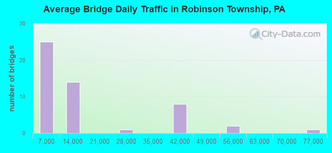
- 731,990Total average daily traffic
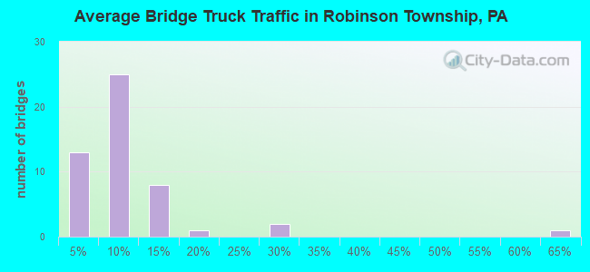
- 68,910Total average daily truck traffic
- National Bridge Inventory (NBI) Registered Bridges for Robinson Township
- No street view available for this location
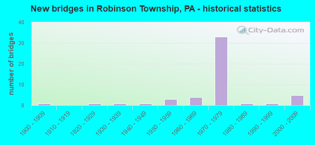
- New bridges - historical statistics
- 11900-1909
- 11920-1929
- 11930-1939
- 11940-1949
- 31950-1959
- 41960-1969
- 331970-1979
- 11980-1989
- 11990-1999
- 52000-2009
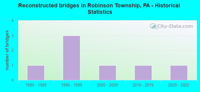
- Reconstructed bridges - Historical Statistics
- 11980-1989
- 31990-1999
- 12000-2009
- 12010-2019
- 12020-2022
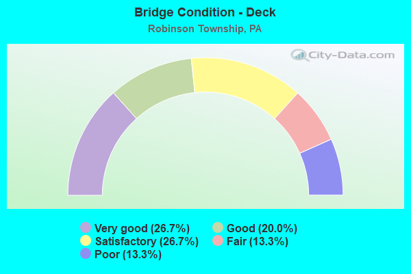
- Bridge Condition - Deck
- 26.7%Very good
- 20.0%Good
- 26.7%Satisfactory
- 13.3%Fair
- 13.3%Poor
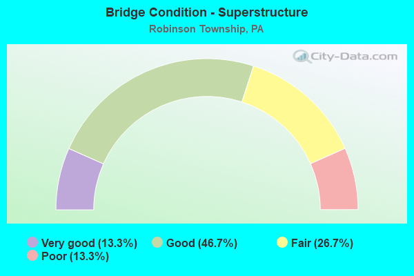
- Bridge Condition - Superstructure
- 13.3%Very good
- 46.7%Good
- 26.7%Fair
- 13.3%Poor
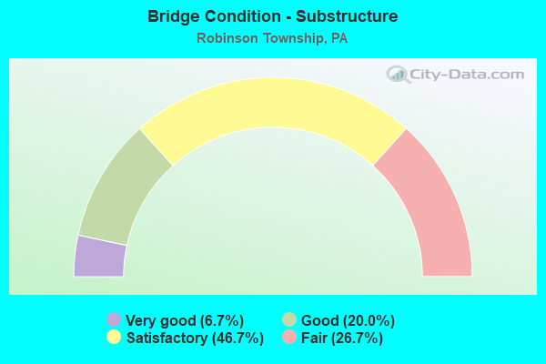
- Bridge Condition - Substructure
- 6.7%Very good
- 20.0%Good
- 46.7%Satisfactory
- 26.7%Fair
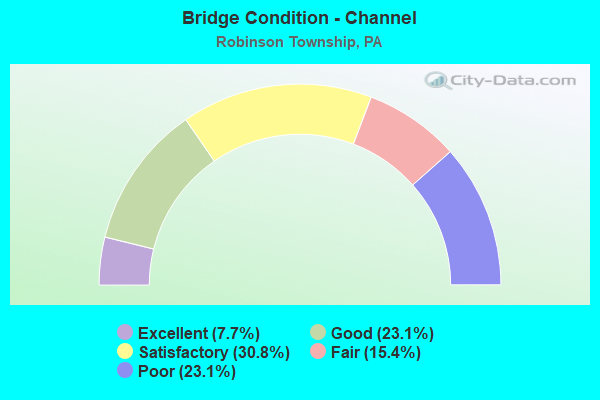
- Bridge Condition - Channel
- 7.7%Excellent
- 23.1%Good
- 30.8%Satisfactory
- 15.4%Fair
- 23.1%Poor
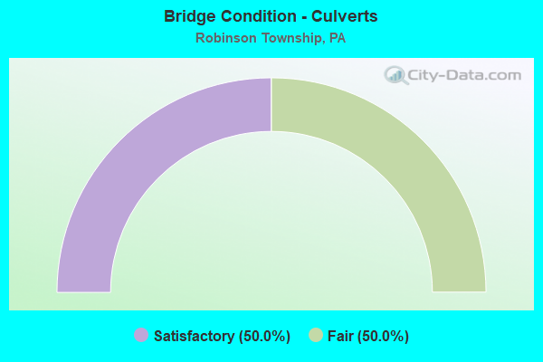
- Bridge Condition - Culverts
- 50.0%Satisfactory
- 50.0%Fair
Find on map >> Show street view
Structure Number: 97, Location: 200'S.W.CAMPBELLS RUN RD. (Lat: 40.422903, Lng: -80.103358), Route carried "on" structure: Interstate 376, Year Built: 1972, Status: Open, Structure Length: 0.67m (2.20ft), Average Daily Traffic: 76,786 (year 2022), Truck Traffic: 9%, Average Future Daily Traffic: 104,466 (year 2032), Design Load: HS 20, Features Intersected: CAMPBELLS RUN, Facility Carried by Structure: PENN LINCOLN PY
Minimum Vertical Clearance: 30+ m (98+ ft), Kilometerpoint: 23.031, Lanes on structure: 5, Base Highway Network: Yes, Owner: State Highway Agency, Approaching Roadway Width: 25.3m (83.0ft), Skew: 33 degrees, Material/Design: Concrete, Design/Construction: Culvert, Number Of Spans In Main Unit: 1, Length of Maximum Span: 6.7m (22.0ft)
Condition: Channel: Satisfactory, Culverts: Satisfactory, Inventory Rating: 99.8 metric tons, Method Used To Determine Inventory Rating: Field evaluation and documented engineering judgment, Structural Evaluation: Equal to present minimum criteria, Waterway Adequacy: Superior to present desirable criteria, Approach Roadway Alignment: Equal to present desirable criteria, Length Of Structure Improvement: 0.70m (2.30ft), Designated Inspection Frequency: Every 24 months, Inspection Date: October 2021
Find on map >> Show street view
Structure Number: 1837, Location: 100' S.E. OF SR 3077 (Lat: 40.466381, Lng: -80.155781), Route carried "on" structure: State highway , Year Built: 1960, Status: Open, Structure Length: 3.69m (12.11ft), Average Daily Traffic: 11,211 (year 2021), Truck Traffic: 2%, Average Future Daily Traffic: 19,330 (year 2032), Design Load: HS 20, Features Intersected: MONT'R TRLWY & MONTOUR R, Facility Carried by Structure: BEAVER GRADE RD
Minimum Vertical Clearance: 30+ m (98+ ft), Kilometerpoint: 3.084, Lanes on structure: 2, Owner: State Highway Agency, Approaching Roadway Width: 11.6m (38.1ft), Skew: 3 degrees, Material/Design: Steel, Design/Construction: Stringer/Multi-beam, Number Of Spans In Main Unit: 2, Length of Maximum Span: 21.3m (69.9ft), Curb or Sidewalk Widths: Left: 0.6m (2.0ft), Right: 0.6m (2.0ft), Curb-To-Curb Width: 11.6m (38.1ft), Out-to-Out Width: 15.8m (51.8ft)
Condition: Deck: Fair, Superstructure: Fair, Substructure: Fair, Channel: Good, Operating Rating: 50.8 metric tons, Method Used To Determine Operating Rating: Load Factor (LF), Inventory Rating: 29.9 metric tons, Method Used To Determine Inventory Rating: Load Factor (LF), Structural Evaluation: Somewhat better than minimum adequacy, Deck Geometry: Somewhat better than minimum adequacy, Waterway Adequacy: Superior to present desirable criteria, Approach Roadway Alignment: Better than present minimum criteria, Length Of Structure Improvement: 3.70m (12.14ft), Designated Inspection Frequency: Every 24 months, Inspection Date: October 2019, Bridge Improvement Cost: $80,000, Roadway Improvement Cost: $235,000, Total Project Cost: $1,078,000, Deck Structure Type: Concrete Cast-file-Place, Wearing Surface/Protective System: Wearing Surface: Bituminous
Find on map >> Show street view
Structure Number: 1841, Location: 1 MI.SW OF NEVILLE ISLE. (Lat: 40.491072, Lng: -80.150231), Route carried "on" structure: State highway , Year Built: 1987, Status: Open, Structure Length: 4.66m (15.29ft), Average Daily Traffic: 1,518 (year 2022), Truck Traffic: 5%, Average Future Daily Traffic: 1,827 (year 2032), Design Load: HS 20, Features Intersected: MONTOUR RUN, Facility Carried by Structure: EWING RD
Minimum Vertical Clearance: 30+ m (98+ ft), Kilometerpoint: 5.515, Lanes on structure: 2, Owner: State Highway Agency, Approaching Roadway Width: 9.4m (30.8ft), Material/Design: Steel, Design/Construction: Stringer/Multi-beam, Number Of Spans In Main Unit: 2, Length of Maximum Span: 22.6m (74.1ft), Curb or Sidewalk Widths: Left: 0.2m (0.7ft), Right: 0.2m (0.7ft), Curb-To-Curb Width: 9.1m (29.9ft), Out-to-Out Width: 9.9m (32.5ft)
Condition: Deck: Satisfactory, Superstructure: Good, Substructure: Satisfactory, Channel: Good, Operating Rating: 88.0 metric tons, Method Used To Determine Operating Rating: Load Factor (LF), Inventory Rating: 52.6 metric tons, Method Used To Determine Inventory Rating: Load Factor (LF), Structural Evaluation: Equal to present minimum criteria, Deck Geometry: Somewhat better than minimum adequacy, Waterway Adequacy: Superior to present desirable criteria, Approach Roadway Alignment: Equal to present minimum criteria, Length Of Structure Improvement: 4.70m (15.42ft), Designated Inspection Frequency: Every 48 months, Inspection Date: May 2021, Deck Structure Type: Concrete Cast-file-Place, Wearing Surface/Protective System: Wearing Surface: Epoxy Overlay, Deck Protection: Epoxy Coated Reinforcing
Find on map >> Show street view
Structure Number: 2191, Location: CM01 .5 MI S/BALDWIN RD (Lat: 40.416608, Lng: -80.099514), Route carried "on" structure: County highway , Year Built: 1938, Status: Open, Structure Length: 1.13m (3.71ft), Average Daily Traffic: 5,401 (year 2019), Truck Traffic: 5%, Average Future Daily Traffic: 6,214 (year 2039), Features Intersected: CAMPBELLS RUN, Facility Carried by Structure: CAMPBELLS RUN RD
Minimum Vertical Clearance: 30+ m (98+ ft), Kilometerpoint: 0.000, Lanes on structure: 2, Owner: County Highway Agency, Approaching Roadway Width: 8.5m (27.9ft), Skew: 4 degrees, Material/Design: Concrete, Design/Construction: Culvert, Number Of Spans In Main Unit: 1, Length of Maximum Span: 11.3m (37.1ft)
Condition: Channel: Poor, Culverts: Fair, Operating Rating: 78.9 metric tons, Method Used To Determine Operating Rating: Load Factor (LF), Inventory Rating: 47.2 metric tons, Method Used To Determine Inventory Rating: Load Factor (LF), Structural Evaluation: Somewhat better than minimum adequacy, Waterway Adequacy: Equal to present desirable criteria, Approach Roadway Alignment: Equal to present desirable criteria, Length Of Structure Improvement: 1.20m (3.94ft), Designated Inspection Frequency: Every 24 months, Inspection Date: April 2021
Find on map >> Show street view
Structure Number: 2192, Location: CM06 .2 MI E/KEINERS LN (Lat: 40.426042, Lng: -80.116806), Route carried "on" structure: County highway , Year Built: 1968, Status: Open, Structure Length: 1.49m (4.89ft), Average Daily Traffic: 6,125 (year 2019), Truck Traffic: 5%, Average Future Daily Traffic: 6,904 (year 2039), Design Load: HS 20, Features Intersected: CAMPBELLS RUN, Facility Carried by Structure: CAMPBELLS RUN RD
Minimum Vertical Clearance: 30+ m (98+ ft), Kilometerpoint: 0.000, Lanes on structure: 2, Owner: County Highway Agency, Approaching Roadway Width: 6.7m (22.0ft), Skew: 4 degrees, Material/Design: Prestressed concrete, Design/Construction: Box Beam or Girders - Multiple, Number Of Spans In Main Unit: 1, Length of Maximum Span: 14.3m (46.9ft), Curb or Sidewalk Widths: Left: 0.2m (0.7ft), Right: 0.2m (0.7ft), Curb-To-Curb Width: 8.2m (26.9ft), Out-to-Out Width: 8.6m (28.2ft)
Condition: Deck: Fair, Superstructure: Poor, Substructure: Fair, Channel: Poor, Operating Rating: 46.3 metric tons, Method Used To Determine Operating Rating: Load Factor (LF), Inventory Rating: 20.9 metric tons, Method Used To Determine Inventory Rating: Load Factor (LF), Structural Evaluation: Meets minimum limits, Deck Geometry: High priority of replacement, Waterway Adequacy: Somewhat better than minimum adequacy, Approach Roadway Alignment: Equal to present desirable criteria, Length Of Structure Improvement: 1.90m (6.23ft), Designated Inspection Frequency: Every 24 months, Inspection Date: April 2021, Bridge Improvement Cost: $7,000, Roadway Improvement Cost: $50,000, Total Project Cost: $93,000, Deck Structure Type: Other, Wearing Surface/Protective System: Wearing Surface: Bituminous
Find on map >> Show street view
Structure Number: 2759, Location: S.B. RP.B O/ PRKY.& LOCAL (Lat: 40.423100, Lng: -80.101722), Route carried "on" structure: Ramp State highway , Year Built: 1973, Year Reconstructed: 2015, Status: Open, Structure Length: 8.14m (26.71ft), Average Daily Traffic: 11,979 (year 2021), Truck Traffic: 8%, Average Future Daily Traffic: 14,244 (year 2032), Design Load: HS 20, Features Intersected: PRKWY&CAMPBELLS RUN RD., Facility Carried by Structure: RAMP B RD
Minimum Vertical Clearance: 30+ m (98+ ft), Kilometerpoint: 0.000, Lanes on structure: 2, Lanes under structure: 8, Base Highway Network: Yes, Owner: State Highway Agency, Approaching Roadway Width: 11.9m (39.0ft), Skew: 6 degrees, Material/Design: Steel, Design/Construction: Stringer/Multi-beam, Number Of Spans In Main Unit: 1, Number Of Approach Spans: 2, Length of Maximum Span: 44.5m (146.0ft), Curb or Sidewalk Widths: Left: 0.2m (0.7ft), Right: 0.2m (0.7ft), Curb-To-Curb Width: 11.9m (39.0ft), Out-to-Out Width: 12.9m (42.3ft)
Condition: Deck: Good, Superstructure: Good, Substructure: Satisfactory, Operating Rating: 68.9 metric tons, Method Used To Determine Operating Rating: Load Factor (LF), Inventory Rating: 41.7 metric tons, Method Used To Determine Inventory Rating: Load Factor (LF), Structural Evaluation: Equal to present minimum criteria, Deck Geometry: Superior to present desirable criteria, Underclear: High priority of corrective action, Approach Roadway Alignment: Better than present minimum criteria, Length Of Structure Improvement: 9.10m (29.86ft), Designated Inspection Frequency: Every 24 months, Inspection Date: June 2020, Bridge Improvement Cost: $48,000, Roadway Improvement Cost: $141,000, Total Project Cost: $646,000, Deck Structure Type: Concrete Cast-file-Place, Wearing Surface/Protective System: Wearing Surface: Monolithic Concrete, Deck Protection: Epoxy Coated Reinforcing
Find on map >> Show street view
Structure Number: 7056, Location: NOCKAMIXON STATE 09G08 (Lat: 40.475528, Lng: -75.226522), Route carried "on" structure: State highway 563, Year Built: 1972, Status: Open, Structure Length: 3.75m (12.30ft), Average Daily Traffic: 4,092 (year 2021), Truck Traffic: 10%, Average Future Daily Traffic: 4,931 (year 2032), Design Load: HS 20, Features Intersected: SAW MILL ROAD, Facility Carried by Structure: MOUNTAIN VIEW ROAD
Minimum Vertical Clearance: 30+ m (98+ ft), Kilometerpoint: 19.320, Lanes on structure: 2, Lanes under structure: 2, Base Highway Network: Yes, Owner: State Highway Agency, Approaching Roadway Width: 13.4m (44.0ft), Skew: 2 degrees, Material/Design: Prestressed concrete, Design/Construction: Stringer/Multi-beam, Number Of Spans In Main Unit: 3, Length of Maximum Span: 16.5m (54.1ft), Curb or Sidewalk Widths: Left: 0.2m (0.7ft), Right: 0.2m (0.7ft), Curb-To-Curb Width: 13.4m (44.0ft), Out-to-Out Width: 14.6m (47.9ft)
Condition: Deck: Very good, Superstructure: Good, Substructure: Good, Operating Rating: 73.5 metric tons, Method Used To Determine Operating Rating: Load Factor (LF), Inventory Rating: 27.2 metric tons, Method Used To Determine Inventory Rating: Load Factor (LF), Structural Evaluation: Equal to present minimum criteria, Deck Geometry: Better than present minimum criteria, Underclear: Meets minimum limits, Approach Roadway Alignment: Equal to present desirable criteria, Length Of Structure Improvement: 4.60m (15.09ft), Designated Inspection Frequency: Every 24 months, Inspection Date: January 2021, Deck Structure Type: Concrete Cast-file-Place, Wearing Surface/Protective System: Wearing Surface: Latex Concrete
Find on map >> Show street view
Structure Number: 829, Location: 0.9 mi S. of SR 4012 (Lat: 41.100272, Lng: -79.860461), Route carried "on" structure: City street , Year Built: 1940, Year Reconstructed: 2005, Status: Open, Structure Length: 1.31m (4.30ft), Average Daily Traffic: 100 (year 2018), Truck Traffic: 9%, Average Future Daily Traffic: 140 (year 2038), Features Intersected: SLIPPERY ROCK CREEK, Facility Carried by Structure: T-506 KOHLMEYER RD
Minimum Vertical Clearance: 30+ m (98+ ft), Kilometerpoint: 0.000, Lanes on structure: 2, Owner: County Highway Agency, Approaching Roadway Width: 3.0m (9.8ft), Material/Design: Steel, Design/Construction: Stringer/Multi-beam, Number Of Spans In Main Unit: 1, Length of Maximum Span: 11.9m (39.0ft), Curb-To-Curb Width: 4.8m (15.7ft), Out-to-Out Width: 5.1m (16.7ft)
Condition: Deck: Satisfactory, Superstructure: Good, Substructure: Satisfactory, Channel: Fair, Inventory Rating: 64.4 metric tons, Method Used To Determine Inventory Rating: Load Factor (LF), Structural Evaluation: Equal to present minimum criteria, Waterway Adequacy: Equal to present desirable criteria, Approach Roadway Alignment: Equal to present desirable criteria, Length Of Structure Improvement: 2.00m (6.56ft), Designated Inspection Frequency: Every 24 months, Inspection Date: Febuary 2020, Bridge Improvement Cost: $2,000, Roadway Improvement Cost: $7,000, Total Project Cost: $30,000, Deck Structure Type: Concrete Cast-file-Place, Wearing Surface/Protective System: Wearing Surface: Monolithic Concrete
Find on map >> Show street view
Structure Number: 21091, Location: 1 MI. S.W. PA 772 (Lat: 40.116861, Lng: -76.233344), Route carried "on" structure: US 222, Year Built: 1972, Status: Open, Structure Length: 7.10m (23.29ft), Average Daily Traffic: 25,696 (year 2020), Truck Traffic: 15%, Average Future Daily Traffic: 33,812 (year 2032), Design Load: HS 20, Features Intersected: COCALICO CREEK
Minimum Vertical Clearance: 30+ m (98+ ft), Kilometerpoint: 56.543, Lanes on structure: 2, Base Highway Network: Yes, Owner: State Highway Agency, Approaching Roadway Width: 11.6m (38.1ft), Skew: 12 degrees, Material/Design: Prestressed concrete, Design/Construction: Box Beam or Girders - Single/Spread, Number Of Spans In Main Unit: 4, Length of Maximum Span: 23.8m (78.1ft), Curb or Sidewalk Widths: Left: 0.2m (0.7ft), Right: 0.2m (0.7ft), Curb-To-Curb Width: 11.9m (39.0ft), Out-to-Out Width: 13.2m (43.3ft)
Condition: Deck: Satisfactory, Superstructure: Fair, Substructure: Fair, Channel: Good, Operating Rating: 58.1 metric tons, Method Used To Determine Operating Rating: Load Factor (LF), Inventory Rating: 22.7 metric tons, Method Used To Determine Inventory Rating: Load Factor (LF), Structural Evaluation: Somewhat better than minimum adequacy, Deck Geometry: Equal to present minimum criteria, Waterway Adequacy: Superior to present desirable criteria, Approach Roadway Alignment: Equal to present desirable criteria, Length Of Structure Improvement: 8.00m (26.25ft), Designated Inspection Frequency: Every 24 months, Inspection Date: August 2020, Bridge Improvement Cost: $50,000, Roadway Improvement Cost: $146,000, Total Project Cost: $670,000, Deck Structure Type: Concrete Cast-file-Place, Wearing Surface/Protective System: Wearing Surface: Latex Concrete
Find on map >> Show street view
Structure Number: 29058, Location: BORO OF MILTON (Lat: 41.020961, Lng: -76.833972), Route carried "on" structure: State highway 147, Year Built: 1971, Year Reconstructed: 2004, Status: Open, Structure Length: 4.72m (15.49ft), Average Daily Traffic: 5,017 (year 2020), Truck Traffic: 27%, Average Future Daily Traffic: 8,555 (year 2032), Design Load: HS 20, Features Intersected: OVER SR 254
Minimum Vertical Clearance: 30+ m (98+ ft), Kilometerpoint: 57.985, Lanes on structure: 2, Lanes under structure: 4, Base Highway Network: Yes, Owner: State Highway Agency, Approaching Roadway Width: 13.4m (44.0ft), Skew: 1 degrees, Material/Design: Prestressed concrete, Design/Construction: Stringer/Multi-beam, Number Of Spans In Main Unit: 3, Length of Maximum Span: 25.6m (84.0ft), Curb or Sidewalk Widths: Left: 0.2m (0.7ft), Right: 0.2m (0.7ft), Curb-To-Curb Width: 13.4m (44.0ft), Out-to-Out Width: 14.6m (47.9ft)
Condition: Deck: Very good, Superstructure: Good, Substructure: Satisfactory, Operating Rating: 69.9 metric tons, Method Used To Determine Operating Rating: Load Factor (LF), Inventory Rating: 36.3 metric tons, Method Used To Determine Inventory Rating: Load Factor (LF), Structural Evaluation: Equal to present minimum criteria, Deck Geometry: Superior to present desirable criteria, Underclear: Better than present minimum criteria, Approach Roadway Alignment: Equal to present desirable criteria, Length Of Structure Improvement: 4.70m (15.42ft), Designated Inspection Frequency: Every 24 months, Inspection Date: December 2021, Deck Structure Type: Concrete Cast-file-Place, Wearing Surface/Protective System: Wearing Surface: Epoxy Overlay
Find on map >> Show street view
Structure Number: 29061, Location: 1.75 MI NORTH OF MILTON (Lat: 41.038597, Lng: -76.840472), Route carried "on" structure: State highway 147, Year Built: 1969, Year Reconstructed: 2003, Status: Open, Structure Length: 1.01m (3.31ft), Average Daily Traffic: 5,017 (year 2020), Truck Traffic: 27%, Average Future Daily Traffic: 8,555 (year 2032), Design Load: HS 20, Features Intersected: MUDDY RUN
Minimum Vertical Clearance: 30+ m (98+ ft), Kilometerpoint: 60.035, Lanes on structure: 2, Base Highway Network: Yes, Owner: State Highway Agency, Approaching Roadway Width: 11.6m (38.1ft), Skew: 11 degrees, Material/Design: Prestressed concrete, Design/Construction: Box Beam or Girders - Single/Spread, Number Of Spans In Main Unit: 1, Length of Maximum Span: 9.8m (32.2ft), Curb or Sidewalk Widths: Left: 0.2m (0.7ft), Right: 0.2m (0.7ft), Curb-To-Curb Width: 11.9m (39.0ft), Out-to-Out Width: 13.4m (44.0ft)
Condition: Deck: Good, Superstructure: Good, Substructure: Good, Channel: Fair, Operating Rating: 77.1 metric tons, Method Used To Determine Operating Rating: Load Factor (LF), Inventory Rating: 42.6 metric tons, Method Used To Determine Inventory Rating: Load Factor (LF), Structural Evaluation: Better than present minimum criteria, Deck Geometry: Better than present minimum criteria, Waterway Adequacy: Superior to present desirable criteria, Approach Roadway Alignment: Equal to present desirable criteria, Length Of Structure Improvement: 1.00m (3.28ft), Designated Inspection Frequency: Every 24 months, Inspection Date: December 2021, Deck Structure Type: Concrete Cast-file-Place, Wearing Surface/Protective System: Wearing Surface: Bituminous, Membrane: Preformed Fabric
Find on map >> Show street view
Structure Number: 2938, Location: WEST OF REBUCK (Lat: 40.717247, Lng: -76.747078), Route carried "on" structure: City street , Year Built: 1960, Year Reconstructed: 1986, Status: Posted for load, Structure Length: 1.25m (4.10ft), Average Daily Traffic: 60 (year 2018), Truck Traffic: 1%, Average Future Daily Traffic: 93 (year 2040), Design Load: HS 20, Features Intersected: SCHWABEN CREEK, Facility Carried by Structure: T-387
Minimum Vertical Clearance: 30+ m (98+ ft), Kilometerpoint: 0.000, Lanes on structure: 1, Owner: County Highway Agency, Approaching Roadway Width: 4.9m (16.1ft), Material/Design: Steel, Design/Construction: Stringer/Multi-beam, Number Of Spans In Main Unit: 1, Length of Maximum Span: 11.3m (37.1ft), Curb or Sidewalk Widths: Left: 0.4m (1.3ft), Right: 0.4m (1.3ft), Curb-To-Curb Width: 5.1m (16.7ft), Out-to-Out Width: 5.5m (18.0ft)
Condition: Deck: Poor, Superstructure: Poor, Substructure: Satisfactory, Channel: Satisfactory, Operating Rating: 19.1 metric tons, Method Used To Determine Operating Rating: Load Factor (LF), Inventory Rating: 10.9 metric tons, Method Used To Determine Inventory Rating: Load Factor (LF), Structural Evaluation: Meets minimum limits, Deck Geometry: High priority of corrective action, Waterway Adequacy: Equal to present desirable criteria, Approach Roadway Alignment: Better than present minimum criteria, Bridge Posting: Required (Relationship of Operating Rating to Maximum Legal Load: > 39.9% below), Length Of Structure Improvement: 1.10m (3.61ft), Designated Inspection Frequency: Every 24 months, Other Special Inspection Frequency: Every 12 months, Inspection Date: May 2020, Other Special Inspection Date: May 2021, Deck Structure Type: Wood or Timber
Find on map >> Show street view
Structure Number: 2939, Location: TREVORTON (Lat: 40.782336, Lng: -76.678150), Route carried "on" structure: City street 80T, Year Built: 1904, Year Reconstructed: 1997, Status: Posted for load, Structure Length: 0.82m (2.69ft), Average Daily Traffic: 400 (year 2017), Truck Traffic: 4%, Average Future Daily Traffic: 618 (year 2039), Design Load: HS 20, Features Intersected: Zerbe Run, Facility Carried by Structure: T-506 (8th Street)
Minimum Vertical Clearance: 30+ m (98+ ft), Kilometerpoint: 0.000, Lanes on structure: 2, Owner: County Highway Agency, Approaching Roadway Width: 6.7m (22.0ft), Material/Design: Steel, Design/Construction: Stringer/Multi-beam, Number Of Spans In Main Unit: 1, Length of Maximum Span: 7.9m (25.9ft), Curb-To-Curb Width: 5.5m (18.0ft), Out-to-Out Width: 5.8m (19.0ft)
Condition: Deck: Poor, Superstructure: Fair, Substructure: Fair, Channel: Satisfactory, Operating Rating: 44.5 metric tons, Method Used To Determine Operating Rating: Load Factor (LF), Inventory Rating: 26.3 metric tons, Method Used To Determine Inventory Rating: Load Factor (LF), Structural Evaluation: Somewhat better than minimum adequacy, Deck Geometry: High priority of corrective action, Waterway Adequacy: Better than present minimum criteria, Approach Roadway Alignment: Equal to present desirable criteria, Bridge Posting: Required (Relationship of Operating Rating to Maximum Legal Load: 10.0 - 19.9% below), Length Of Structure Improvement: 1.00m (3.28ft), Designated Inspection Frequency: Every 24 months, Other Special Inspection Frequency: Every 12 months, Inspection Date: December 2021, Other Special Inspection Date: December 2021, Deck Structure Type: Wood or Timber, Wearing Surface/Protective System: Wearing Surface: Bituminous, Membrane: Preformed Fabric
Find on map >> Show street view
Structure Number: 35533, Location: DAMASCUS TWP .1M W SR1031 (Lat: 41.698169, Lng: -75.079742), Route carried "on" structure: State highway 371, Year Built: 1951, Status: Open, Structure Length: 1.65m (5.41ft), Average Daily Traffic: 1,313 (year 2021), Truck Traffic: 8%, Average Future Daily Traffic: 1,691 (year 2032), Design Load: H 20, Features Intersected: BEAVER DAM CREEK
Minimum Vertical Clearance: 30+ m (98+ ft), Kilometerpoint: 35.080, Lanes on structure: 2, Owner: State Highway Agency, Approaching Roadway Width: 6.7m (22.0ft), Material/Design: Steel, Design/Construction: Stringer/Multi-beam, Number Of Spans In Main Unit: 1, Length of Maximum Span: 15.2m (49.9ft), Curb or Sidewalk Widths: Left: 0.2m (0.7ft), Right: 0.2m (0.7ft), Curb-To-Curb Width: 9.1m (29.9ft), Out-to-Out Width: 9.7m (31.8ft)
Condition: Deck: Satisfactory, Superstructure: Fair, Substructure: Satisfactory, Channel: Poor, Operating Rating: 49.9 metric tons, Method Used To Determine Operating Rating: Load Factor (LF), Inventory Rating: 29.9 metric tons, Method Used To Determine Inventory Rating: Load Factor (LF), Structural Evaluation: Somewhat better than minimum adequacy, Deck Geometry: Somewhat better than minimum adequacy, Waterway Adequacy: Equal to present minimum criteria, Approach Roadway Alignment: Equal to present desirable criteria, Length Of Structure Improvement: 1.60m (5.25ft), Designated Inspection Frequency: Every 24 months, Other Special Inspection Frequency: Every 12 months, Inspection Date: April 2021, Other Special Inspection Date: April 2021, Deck Structure Type: Concrete Cast-file-Place, Wearing Surface/Protective System: Wearing Surface: Bituminous
Find on map >> Show street view
Structure Number: 43031, Location: SETTLERS CABIN INTERCHANG (Lat: 40.439233, Lng: -80.153167), Route carried "on" structure: Ramp State highway , Year Built: 2005, Status: Open, Structure Length: 5.85m (19.19ft), Average Daily Traffic: 7,414 (year 2020), Truck Traffic: 2%, Average Future Daily Traffic: 8,009 (year 2032), Design Load: HS 20, Features Intersected: SR 0376 EB WB, Facility Carried by Structure: RIDGE ROAD
Minimum Vertical Clearance: 5.15m (16.90ft), Kilometerpoint: 0.000, Lanes on structure: 4, Lanes under structure: 10, Owner: State Highway Agency, Approaching Roadway Width: 32.6m (107.0ft), Skew: 21 degrees, Material/Design: Steel, Design/Construction: Stringer/Multi-beam, Number Of Spans In Main Unit: 1, Length of Maximum Span: 57.0m (187.0ft), Curb or Sidewalk Widths: Left: 0.2m (0.7ft), Right: 0.2m (0.7ft), Curb-To-Curb Width: 32.4m (106.3ft), Out-to-Out Width: 33.3m (109.3ft)
Condition: Deck: Good, Superstructure: Good, Substructure: Good, Operating Rating: 59.0 metric tons, Method Used To Determine Operating Rating: Load Factor (LF), Inventory Rating: 35.4 metric tons, Method Used To Determine Inventory Rating: Load Factor (LF), Structural Evaluation: Better than present minimum criteria, Deck Geometry: Superior to present desirable criteria, Underclear: Meets minimum limits, Approach Roadway Alignment: Equal to present desirable criteria, Length Of Structure Improvement: 6.90m (22.64ft), Designated Inspection Frequency: Every 24 months, Inspection Date: May 2021, Deck Structure Type: Concrete Cast-file-Place, Wearing Surface/Protective System: Wearing Surface: Monolithic Concrete, Deck Protection: Epoxy Coated Reinforcing
Find on map >> Show street view
Structure Number: 45198, Location: 79/376 INTERCHANGE (Lat: 40.425039, Lng: -80.107478), Route carried "on" structure: Ramp State highway , Year Built: 2008, Status: Open, Structure Length: 19.63m (64.40ft), Average Daily Traffic: 5,318 (year 2021), Truck Traffic: 13%, Average Future Daily Traffic: 7,011 (year 2032), Design Load: HL 93, Features Intersected: CAMPBELL RUN RD AND RUN, Facility Carried by Structure: SR 8009 RAMP H
Minimum Vertical Clearance: 30+ m (98+ ft), Kilometerpoint: 0.000, Lanes on structure: 1, Lanes under structure: 2, Base Highway Network: Yes, Owner: State Highway Agency, Approaching Roadway Width: 8.8m (28.9ft), Material/Design: Prestressed concrete continuous, Design/Construction: Stringer/Multi-beam, Number Of Spans In Main Unit: 5, Length of Maximum Span: 40.8m (133.9ft), Curb-To-Curb Width: 8.8m (28.9ft), Out-to-Out Width: 9.8m (32.2ft)
Condition: Deck: Very good, Superstructure: Very good, Substructure: Very good, Channel: Excellent, Operating Rating: 62.5 metric tons, Method Used To Determine Operating Rating: Assigned ratings based on Load and Resistance Factor Design (LRFD) reported by rating factor (RF) using HL93 loadings, Inventory Rating: 38.6 metric tons, Method Used To Determine Inventory Rating: Assigned ratings based on Load and Resistance Factor Design (LRFD) reported by rating factor (RF) using HL93 loadings, Structural Evaluation: Equal to present desirable criteria, Deck Geometry: Superior to present desirable criteria, Underclear: Meets minimum limits, Waterway Adequacy: Superior to present desirable criteria, Approach Roadway Alignment: Equal to present minimum criteria, Designated Inspection Frequency: Every 48 months, Inspection Date: June 2018, Deck Structure Type: Concrete Cast-file-Place, Wearing Surface/Protective System: Wearing Surface: Monolithic Concrete, Deck Protection: Epoxy Coated Reinforcing
Find on map >> Show street view
Structure Number: 49133, Location: 1200 ft North of SR 51 (Lat: 40.504517, Lng: -80.138544), Route carried "on" structure: City street , Year Built: 1990, Year Reconstructed: 2020, Status: Open, Structure Length: 0.67m (2.20ft), Average Daily Traffic: 100 (year 2015), Truck Traffic: 4%, Average Future Daily Traffic: 150 (year 2035), Design Load: HL 93, Features Intersected: Moon Run, Facility Carried by Structure: Station St.
Minimum Vertical Clearance: 30+ m (98+ ft), Kilometerpoint: 0.000, Lanes on structure: 2, Owner: Town or Township Highway Agency, Approaching Roadway Width: 7.3m (24.0ft), Material/Design: Prestressed concrete, Design/Construction: Box Beam or Girders - Multiple, Number Of Spans In Main Unit: 1, Length of Maximum Span: 6.1m (20.0ft), Curb or Sidewalk Widths: Left: 0.5m (1.6ft), Right: 0.5m (1.6ft), Curb-To-Curb Width: 7.7m (25.3ft), Out-to-Out Width: 8.6m (28.2ft)
Condition: Deck: Very good, Superstructure: Very good, Substructure: Satisfactory, Channel: Satisfactory, Operating Rating: 90.7 metric tons, Method Used To Determine Operating Rating: Load and Resistance Factor (LRFR), Inventory Rating: 70.8 metric tons, Method Used To Determine Inventory Rating: Load and Resistance Factor (LRFR), Structural Evaluation: Equal to present minimum criteria, Deck Geometry: Equal to present minimum criteria, Waterway Adequacy: High priority of corrective action, Approach Roadway Alignment: Better than present minimum criteria, Designated Inspection Frequency: Every 24 months, Inspection Date: April 2020, Deck Structure Type: Concrete Cast-file-Place, Wearing Surface/Protective System: Wearing Surface: Monolithic Concrete
Find on map >> Show street view
Structure Number: 555, Location: SR 0022/30 OVER SR 0376 (Lat: 40.447239, Lng: -80.166042), Route carried "under" structure: Interstate 376, Year Built: 1950, Structure Length: 0. m, Average Daily Traffic: 50,457 (year 2022), Truck Traffic: 9%, Features Intersected: SR 0376 EB WB, Facility Carried by Structure: SR 22/30
Minimum Vertical Clearance: 4.62m (15.16ft), Kilometerpoint: 17.411, Lanes on structure: 5, Lanes under structure: 3, Material/Design: Steel, Design/Construction: Stringer/Multi-beam, Length of Maximum Span: 26.5m (86.9ft)
Find on map >> Show street view
Structure Number: 555, Location: SR 0022/30 OVER SR 0376 (Lat: 40.447239, Lng: -80.166042), Route carried "under" structure: Interstate 376, Year Built: 1950, Structure Length: 0. m, Average Daily Traffic: 40,445 (year 2022), Truck Traffic: 10%, Features Intersected: SR 0376 EB WB, Facility Carried by Structure: SR 22/30
Minimum Vertical Clearance: 4.62m (15.16ft), Kilometerpoint: 17.413, Lanes on structure: 5, Lanes under structure: 3, Material/Design: Steel, Design/Construction: Stringer/Multi-beam, Length of Maximum Span: 26.5m (86.9ft)
Find on map >> Show street view
Structure Number: 755, Location: OVER TWP.RD.142 (Lat: 40.504892, Lng: -80.144653), Route carried "under" structure: City street , Year Built: 1929, Structure Length: 0. m, Average Daily Traffic: 150 (year 2005), Truck Traffic: 1%, Features Intersected: TWP 142 & MONTOUR RUN, Facility Carried by Structure: CORAOPOLIS BLVD
Minimum Vertical Clearance: 7.54m (24.74ft), Kilometerpoint: 0.000, Lanes on structure: 2, Lanes under structure: 2, Material/Design: Steel, Design/Construction: Girder and Floorbeam System, Length of Maximum Span: 26.8m (87.9ft)
Find on map >> Show street view
Structure Number: 876, Location: I-79 SB OVER RAMP B (Lat: 40.420028, Lng: -80.104289), Route carried "under" structure: Ramp State highway , Year Built: 1973, Structure Length: 0. m, Average Daily Traffic: 11,979 (year 2021), Truck Traffic: 8%, Features Intersected: SR 8009 RAMP B, Facility Carried by Structure: RAYMOND SHAFER HW
Minimum Vertical Clearance: 5.26m (17.26ft), Kilometerpoint: 0.000, Lanes on structure: 3, Lanes under structure: 2, Material/Design: Steel, Design/Construction: Stringer/Multi-beam, Length of Maximum Span: 30.8m (101.0ft)
Find on map >> Show street view
Structure Number: 877, Location: I-79 N.B. OVER 0376 EB-WB (Lat: 40.425422, Lng: -80.106103), Route carried "under" structure: Interstate 376, Year Built: 1973, Structure Length: 0. m, Average Daily Traffic: 38,532 (year 2022), Truck Traffic: 9%, Features Intersected: SR 0022, Facility Carried by Structure: RAYMOND SHAFER HW
Minimum Vertical Clearance: 5.66m (18.57ft), Kilometerpoint: 23.018, Lanes on structure: 3, Lanes under structure: 3, Material/Design: Steel, Design/Construction: Stringer/Multi-beam, Length of Maximum Span: 49.1m (161.1ft)
Find on map >> Show street view
Structure Number: 877, Location: I-79 N.B. OVER 0376 EB-WB (Lat: 40.425422, Lng: -80.106103), Route carried "under" structure: Interstate 376, Year Built: 1973, Structure Length: 0. m, Average Daily Traffic: 38,254 (year 2022), Truck Traffic: 9%, Features Intersected: SR 0022, Facility Carried by Structure: RAYMOND SHAFER HW
Minimum Vertical Clearance: 5.41m (17.75ft), Kilometerpoint: 23.031, Lanes on structure: 3, Lanes under structure: 3, Material/Design: Steel, Design/Construction: Stringer/Multi-beam, Length of Maximum Span: 49.1m (161.1ft)
Find on map >> Show street view
Structure Number: 877, Location: I-79 N.B. OVER 0376 EB-WB (Lat: 40.425422, Lng: -80.106103), Route carried "under" structure: Ramp State highway , Year Built: 1973, Structure Length: 0. m, Average Daily Traffic: 13,342 (year 2016), Truck Traffic: 8%, Features Intersected: SR 0022, Facility Carried by Structure: RAYMOND SHAFER HW
Minimum Vertical Clearance: 5.84m (19.16ft), Kilometerpoint: 0.000, Lanes on structure: 3, Lanes under structure: 1, Material/Design: Steel, Design/Construction: Stringer/Multi-beam, Length of Maximum Span: 49.1m (161.1ft)
Find on map >> Show street view
Structure Number: 877, Location: I-79 N.B. OVER 0376 EB-WB (Lat: 40.425422, Lng: -80.106103), Route carried "under" structure: Ramp State highway , Year Built: 1973, Structure Length: 0. m, Average Daily Traffic: 4,234 (year 2016), Truck Traffic: 8%, Features Intersected: SR 0022, Facility Carried by Structure: RAYMOND SHAFER HW
Minimum Vertical Clearance: 5.28m (17.32ft), Kilometerpoint: 0.000, Lanes on structure: 3, Lanes under structure: 1, Material/Design: Steel, Design/Construction: Stringer/Multi-beam, Length of Maximum Span: 49.1m (161.1ft)
Find on map >> Show street view
Structure Number: 879, Location: I-79 NB O/CAMPBELLS RN RD (Lat: 40.427258, Lng: -80.105914), Route carried "under" structure: County highway , Year Built: 1973, Structure Length: 0. m, Average Daily Traffic: 10,000 (year 1991), Truck Traffic: 1%, Features Intersected: CAMPBELLS RUN RD, Facility Carried by Structure: RAYMOND SHAFER HW
Minimum Vertical Clearance: 5.23m (17.16ft), Kilometerpoint: 0.000, Lanes on structure: 2, Lanes under structure: 2, Material/Design: Prestressed concrete, Design/Construction: Box Beam or Girders - Multiple, Length of Maximum Span: 19.8m (65.0ft)
Find on map >> Show street view
Structure Number: 881, Location: SR79 SB OVER 0376 EB-WB (Lat: 40.425497, Lng: -80.106408), Route carried "under" structure: Interstate 376, Year Built: 1973, Structure Length: 0. m, Average Daily Traffic: 38,254 (year 2022), Truck Traffic: 9%, Features Intersected: SR 0376, Facility Carried by Structure: RAYMOND SHAFER HW
Minimum Vertical Clearance: 5.43m (17.81ft), Kilometerpoint: 23.031, Lanes on structure: 3, Lanes under structure: 3, Material/Design: Steel, Design/Construction: Stringer/Multi-beam, Length of Maximum Span: 48.2m (158.1ft)
Find on map >> Show street view
Structure Number: 881, Location: SR79 SB OVER 0376 EB-WB (Lat: 40.425497, Lng: -80.106408), Route carried "under" structure: Interstate 376, Year Built: 1973, Structure Length: 0. m, Average Daily Traffic: 38,532 (year 2022), Truck Traffic: 9%, Features Intersected: SR 0376, Facility Carried by Structure: RAYMOND SHAFER HW
Minimum Vertical Clearance: 5.64m (18.50ft), Kilometerpoint: 23.018, Lanes on structure: 3, Lanes under structure: 3, Material/Design: Steel, Design/Construction: Stringer/Multi-beam, Length of Maximum Span: 48.2m (158.1ft)
Find on map >> Show street view
Structure Number: 882, Location: I-79 SB O/CAMPBELLS RN RD (Lat: 40.427356, Lng: -80.106289), Route carried "under" structure: County highway , Year Built: 1973, Structure Length: 0. m, Average Daily Traffic: 10,000 (year 1991), Truck Traffic: 1%, Features Intersected: CAMPBELLS RUN RD, Facility Carried by Structure: RAYMOND P SHAFE HY
Minimum Vertical Clearance: 5.26m (17.26ft), Kilometerpoint: 0.000, Lanes on structure: 2, Lanes under structure: 2, Material/Design: Prestressed concrete, Design/Construction: Box Beam or Girders - Multiple, Length of Maximum Span: 20.1m (65.9ft)
Find on map >> Show street view
Structure Number: 886, Location: I-79 NB OVER SR 0060 (Lat: 40.450144, Lng: -80.110747), Route carried "under" structure: State highway 60, Year Built: 1971, Structure Length: 0. m, Average Daily Traffic: 8,756 (year 2022), Truck Traffic: 10%, Features Intersected: SR 0060, Facility Carried by Structure: RAYMOND SHAFER HW
Minimum Vertical Clearance: 5.39m (17.68ft), Kilometerpoint: 9.175, Lanes on structure: 2, Lanes under structure: 7, Material/Design: Prestressed concrete continuous, Design/Construction: Stringer/Multi-beam, Length of Maximum Span: 32.6m (107.0ft)
Find on map >> Show street view
Structure Number: 887, Location: I-79 SB OVER SR 0376 (Lat: 40.450147, Lng: -80.111081), Route carried "under" structure: State highway 60, Year Built: 1971, Structure Length: 0. m, Average Daily Traffic: 8,756 (year 2022), Truck Traffic: 10%, Features Intersected: SR 0060, Facility Carried by Structure: RAYMOND SHAFER HW
Minimum Vertical Clearance: 5.21m (17.09ft), Kilometerpoint: 9.175, Lanes on structure: 3, Lanes under structure: 7, Material/Design: Prestressed concrete continuous, Design/Construction: Stringer/Multi-beam, Length of Maximum Span: 32.6m (107.0ft)
Find on map >> Show street view
Structure Number: 894, Location: GROVETON-I79 NB OVER TR51 (Lat: 40.503617, Lng: -80.137217), Route carried "under" structure: State highway 51, Year Built: 1974, Structure Length: 0. m, Average Daily Traffic: 4,309 (year 2020), Truck Traffic: 4%, Features Intersected: SR 0051 AT GROVETON, Facility Carried by Structure: RAYMOND SHAFER HW
Minimum Vertical Clearance: 4.60m (15.09ft), Kilometerpoint: 46.420, Lanes on structure: 2, Lanes under structure: 4, Material/Design: Steel, Design/Construction: Stringer/Multi-beam, Length of Maximum Span: 32.6m (107.0ft)
Find on map >> Show street view
Structure Number: 894, Location: GROVETON-I79 NB OVER TR51 (Lat: 40.503617, Lng: -80.137217), Route carried "under" structure: State highway 51, Year Built: 1974, Structure Length: 0. m, Average Daily Traffic: 3,901 (year 2020), Truck Traffic: 6%, Features Intersected: SR 0051 AT GROVETON, Facility Carried by Structure: RAYMOND SHAFER HW
Minimum Vertical Clearance: 4.60m (15.09ft), Kilometerpoint: 46.420, Lanes on structure: 2, Lanes under structure: 4, Material/Design: Steel, Design/Construction: Stringer/Multi-beam, Length of Maximum Span: 32.6m (107.0ft)
Find on map >> Show street view
Structure Number: 896, Location: GROVETON-I79 SB OVER SR51 (Lat: 40.503653, Lng: -80.137583), Route carried "under" structure: State highway 51, Year Built: 1974, Structure Length: 0. m, Average Daily Traffic: 4,309 (year 2020), Truck Traffic: 4%, Features Intersected: SR 0051 AT GROVETON, Facility Carried by Structure: RAYMOND SHAFER HW
Minimum Vertical Clearance: 6.77m (22.21ft), Kilometerpoint: 46.420, Lanes on structure: 2, Lanes under structure: 5, Material/Design: Steel continuous, Design/Construction: Stringer/Multi-beam, Length of Maximum Span: 31.7m (104.0ft)
Find on map >> Show street view
Structure Number: 896, Location: GROVETON-I79 SB OVER SR51 (Lat: 40.503653, Lng: -80.137583), Route carried "under" structure: State highway 51, Year Built: 1974, Structure Length: 0. m, Average Daily Traffic: 3,901 (year 2020), Truck Traffic: 6%, Features Intersected: SR 0051 AT GROVETON, Facility Carried by Structure: RAYMOND SHAFER HW
Minimum Vertical Clearance: 6.77m (22.21ft), Kilometerpoint: 46.420, Lanes on structure: 2, Lanes under structure: 5, Material/Design: Steel continuous, Design/Construction: Stringer/Multi-beam, Length of Maximum Span: 31.7m (104.0ft)
Find on map >> Show street view
Structure Number: 897, Location: Neville Island Bridge (Lat: 40.506472, Lng: -80.137122), Route carried "under" structure: State highway 65, Year Built: 1976, Structure Length: 0. m, Average Daily Traffic: 13,930 (year 2020), Truck Traffic: 6%, Features Intersected: CSX RR,NS RR, OHIO RIVER, Facility Carried by Structure: Neville Island Brg
Minimum Vertical Clearance: 4.49m (14.73ft), Kilometerpoint: 12.529, Lanes on structure: 2, Lanes under structure: 2, Material/Design: Steel, Design/Construction: Arch - Thru, Length of Maximum Span: 228.6m (750.0ft)
Find on map >> Show street view
Structure Number: 897, Location: Neville Island Bridge (Lat: 40.506472, Lng: -80.137122), Route carried "under" structure: Ramp State highway , Year Built: 1976, Structure Length: 0. m, Average Daily Traffic: 2,409 (year 2021), Truck Traffic: 7%, Features Intersected: CSX RR,NS RR, OHIO RIVER, Facility Carried by Structure: Neville Island Brg
Minimum Vertical Clearance: 4.50m (14.76ft), Kilometerpoint: 0.000, Lanes on structure: 2, Lanes under structure: 1, Material/Design: Steel, Design/Construction: Arch - Thru, Length of Maximum Span: 228.6m (750.0ft)
Find on map >> Show street view
Structure Number: 897, Location: Neville Island Bridge (Lat: 40.506472, Lng: -80.137122), Route carried "under" structure: State highway 65, Year Built: 1976, Structure Length: 0. m, Average Daily Traffic: 13,127 (year 2020), Truck Traffic: 7%, Features Intersected: CSX RR,NS RR, OHIO RIVER, Facility Carried by Structure: Neville Island Brg
Minimum Vertical Clearance: 4.49m (14.73ft), Kilometerpoint: 12.392, Lanes on structure: 2, Lanes under structure: 2, Material/Design: Steel, Design/Construction: Arch - Thru, Length of Maximum Span: 228.6m (750.0ft)
Find on map >> Show street view
Structure Number: 897, Location: Neville Island Bridge (Lat: 40.506472, Lng: -80.137122), Route carried "under" structure: Ramp State highway , Year Built: 1976, Structure Length: 0. m, Average Daily Traffic: 2,622 (year 2021), Truck Traffic: 7%, Features Intersected: CSX RR,NS RR, OHIO RIVER, Facility Carried by Structure: Neville Island Brg
Minimum Vertical Clearance: 12.55m (41.17ft), Kilometerpoint: 0.000, Lanes on structure: 2, Lanes under structure: 2, Material/Design: Steel, Design/Construction: Arch - Thru, Length of Maximum Span: 228.6m (750.0ft)
Find on map >> Show street view
Structure Number: 897, Location: Neville Island Bridge (Lat: 40.506472, Lng: -80.137122), Route carried "under" structure: Ramp State highway , Year Built: 1976, Structure Length: 0. m, Average Daily Traffic: 1,943 (year 2021), Truck Traffic: 7%, Features Intersected: CSX RR,NS RR, OHIO RIVER, Facility Carried by Structure: Neville Island Brg
Minimum Vertical Clearance: 4.44m (14.57ft), Kilometerpoint: 0.000, Lanes on structure: 2, Lanes under structure: 1, Material/Design: Steel, Design/Construction: Arch - Thru, Length of Maximum Span: 228.6m (750.0ft)
Find on map >> Show street view
Structure Number: 971, Location: 1000' EAST OF SR 0079 (Lat: 40.422744, Lng: -80.102478), Route carried "under" structure: County highway , Year Built: 1973, Structure Length: 0. m, Average Daily Traffic: 1 (year 2005), Truck Traffic: 1%, Features Intersected: CAMPBELLS RUN ROAD, Facility Carried by Structure: PARKWAY WEST
Minimum Vertical Clearance: 4.42m (14.50ft), Kilometerpoint: 0.000, Lanes on structure: 4, Lanes under structure: 2, Material/Design: Steel, Design/Construction: Stringer/Multi-beam, Length of Maximum Span: 17.1m (56.1ft)
Find on map >> Show street view
Structure Number: 2756, Location: 79/376 INTERCHANGE (Lat: 40.422219, Lng: -80.100267), Route carried "under" structure: County highway , Year Built: 1973, Structure Length: 0. m, Average Daily Traffic: 8,000 (year 2003), Truck Traffic: 64%, Features Intersected: CAMPBELL RUN ROAD, Facility Carried by Structure: RAMP A TO 376 EB
Minimum Vertical Clearance: 17.02m (55.84ft), Kilometerpoint: 0.000, Lanes on structure: 1, Lanes under structure: 2, Material/Design: Prestressed concrete, Design/Construction: Stringer/Multi-beam, Length of Maximum Span: 24.7m (81.0ft)
Find on map >> Show street view
Structure Number: 2759, Location: S.B. RP.B O/ PRKY.& LOCAL (Lat: 40.423100, Lng: -80.101722), Route carried "under" structure: Interstate 376, Year Built: 1973, Structure Length: 0. m, Average Daily Traffic: 38,532 (year 2022), Truck Traffic: 9%, Features Intersected: PRKWY&CAMPBELLS RUN RD., Facility Carried by Structure: RAMP B RD
Minimum Vertical Clearance: 5.28m (17.32ft), Kilometerpoint: 23.018, Lanes on structure: 2, Lanes under structure: 3, Material/Design: Steel, Design/Construction: Stringer/Multi-beam, Length of Maximum Span: 44.5m (146.0ft)
Find on map >> Show street view
Structure Number: 2759, Location: S.B. RP.B O/ PRKY.& LOCAL (Lat: 40.423100, Lng: -80.101722), Route carried "under" structure: County highway , Year Built: 1973, Structure Length: 0. m, Average Daily Traffic: 5,000 (year 1991), Truck Traffic: 1%, Features Intersected: PRKWY&CAMPBELLS RUN RD., Facility Carried by Structure: RAMP B RD
Minimum Vertical Clearance: 9.91m (32.51ft), Kilometerpoint: 0.000, Lanes on structure: 2, Lanes under structure: 2, Material/Design: Steel, Design/Construction: Stringer/Multi-beam, Length of Maximum Span: 44.5m (146.0ft)
Find on map >> Show street view
Structure Number: 2759, Location: S.B. RP.B O/ PRKY.& LOCAL (Lat: 40.423100, Lng: -80.101722), Route carried "under" structure: Interstate 376, Year Built: 1973, Structure Length: 0. m, Average Daily Traffic: 38,254 (year 2022), Truck Traffic: 9%, Features Intersected: PRKWY&CAMPBELLS RUN RD., Facility Carried by Structure: RAMP B RD
Minimum Vertical Clearance: 5.28m (17.32ft), Kilometerpoint: 23.031, Lanes on structure: 2, Lanes under structure: 3, Material/Design: Steel, Design/Construction: Stringer/Multi-beam, Length of Maximum Span: 44.5m (146.0ft)
Find on map >> Show street view
Structure Number: 276, Location: PARKWAY RAMP TO I79 N.B. (Lat: 40.424169, Lng: -80.102928), Route carried "under" structure: County highway , Year Built: 1971, Structure Length: 0. m, Average Daily Traffic: 4,000 (year 1991), Truck Traffic: 1%, Features Intersected: BALDWIN RD {6014-02}, Facility Carried by Structure: RAMP F RD
Minimum Vertical Clearance: 4.40m (14.44ft), Kilometerpoint: 0.000, Lanes on structure: 1, Lanes under structure: 2, Material/Design: Prestressed concrete continuous, Design/Construction: Box Beam or Girders - Single/Spread, Length of Maximum Span: 14.9m (48.9ft)
Find on map >> Show street view
Structure Number: 43031, Location: SETTLERS CABIN INTERCHANG (Lat: 40.439233, Lng: -80.153167), Route carried "under" structure: Interstate 376, Year Built: 2005, Structure Length: 0. m, Average Daily Traffic: 50,457 (year 2022), Truck Traffic: 9%, Features Intersected: SR 0376 EB WB, Facility Carried by Structure: RIDGE ROAD
Minimum Vertical Clearance: 5.43m (17.81ft), Kilometerpoint: 18.216, Lanes on structure: 4, Lanes under structure: 5, Material/Design: Steel, Design/Construction: Stringer/Multi-beam, Length of Maximum Span: 57.0m (187.0ft)
Find on map >> Show street view
Structure Number: 43031, Location: SETTLERS CABIN INTERCHANG (Lat: 40.439233, Lng: -80.153167), Route carried "under" structure: Interstate 376, Year Built: 2005, Structure Length: 0. m, Average Daily Traffic: 40,445 (year 2022), Truck Traffic: 10%, Features Intersected: SR 0376 EB WB, Facility Carried by Structure: RIDGE ROAD
Minimum Vertical Clearance: 5.43m (17.81ft), Kilometerpoint: 18.208, Lanes on structure: 4, Lanes under structure: 5, Material/Design: Steel, Design/Construction: Stringer/Multi-beam, Length of Maximum Span: 57.0m (187.0ft)
Find on map >> Show street view
Structure Number: 45198, Location: 79/376 INTERCHANGE (Lat: 40.425039, Lng: -80.107478), Route carried "under" structure: County highway , Year Built: 2008, Structure Length: 0. m, Average Daily Traffic: 100 (year 2017), Features Intersected: CAMPBELL RUN RD AND RUN, Facility Carried by Structure: SR 8009 RAMP H
Minimum Vertical Clearance: 5.92m (19.42ft), Kilometerpoint: 0.000, Lanes on structure: 1, Lanes under structure: 2, Material/Design: Prestressed concrete continuous, Design/Construction: Stringer/Multi-beam, Length of Maximum Span: 40.8m (133.9ft)