Bridge Statistics for Rogersville, Tennessee (TN)
Condition, Traffic, Stress, Structural Evaluation, Project Costs
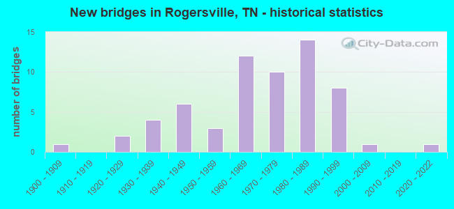
- New bridges - historical statistics
- 11900-1909
- 21920-1929
- 41930-1939
- 61940-1949
- 31950-1959
- 121960-1969
- 101970-1979
- 141980-1989
- 81990-1999
- 12000-2009
- 12020-2022
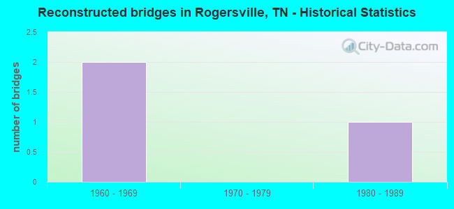
- Reconstructed bridges - Historical Statistics
- 21960-1969
- 01970-1979
- 11980-1989
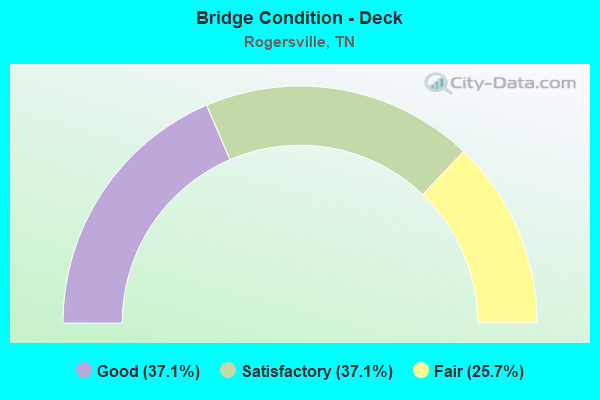
- Bridge Condition - Deck
- 37.1%Good
- 37.1%Satisfactory
- 25.7%Fair
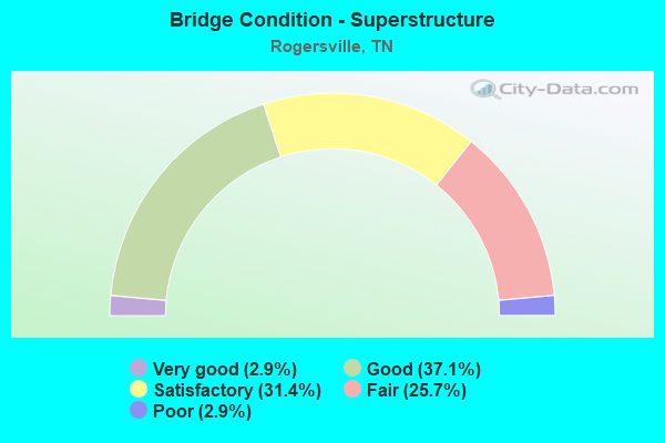
- Bridge Condition - Superstructure
- 2.9%Very good
- 37.1%Good
- 31.4%Satisfactory
- 25.7%Fair
- 2.9%Poor
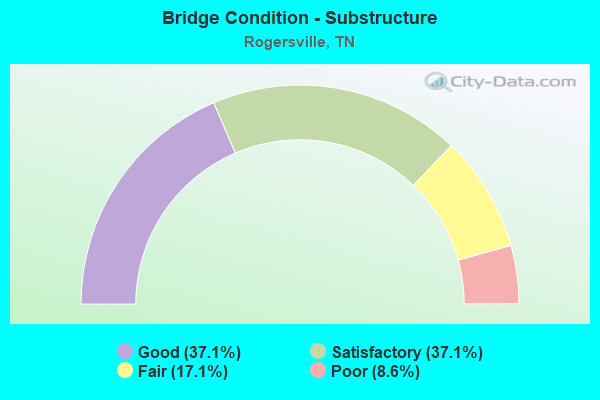
- Bridge Condition - Substructure
- 37.1%Good
- 37.1%Satisfactory
- 17.1%Fair
- 8.6%Poor
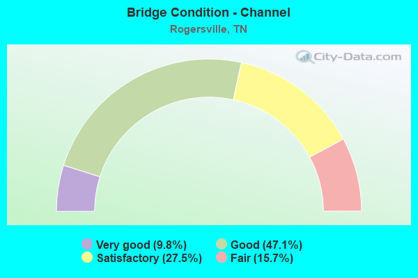
- Bridge Condition - Channel
- 9.8%Very good
- 47.1%Good
- 27.5%Satisfactory
- 15.7%Fair
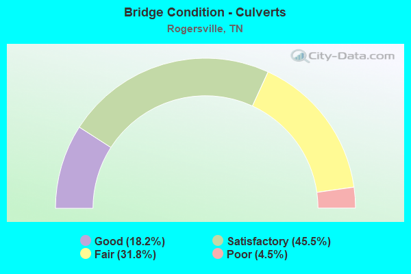
- Bridge Condition - Culverts
- 18.2%Good
- 45.5%Satisfactory
- 31.8%Fair
- 4.5%Poor
Find on map >> Show street view
Structure Number: 37025450001, Location: 4.5 M N OF SR70 AT GREENE (Lat: 36.397933, Lng: -82.928733), Route carried "on" structure: County highway 2545, Year Built: 1965, Year Reconstructed: 1972, Status: Posted for load, Structure Length: 4.05m (13.29ft), Average Daily Traffic: 261 (year 2020), Truck Traffic: 3%, Average Future Daily Traffic: 418 (year 2041), Features Intersected: CHEROKEE LAKE-BEECH CR.
Minimum Vertical Clearance: 30+ m (98+ ft), Kilometerpoint: 2.543, Lanes on structure: 2, Owner: County Highway Agency, Approaching Roadway Width: 6.1m (20.0ft), Material/Design: Steel continuous, Design/Construction: Stringer/Multi-beam, Number Of Spans In Main Unit: 3, Length of Maximum Span: 14.9m (48.9ft), Curb-To-Curb Width: 4.9m (16.1ft), Out-to-Out Width: 5.4m (17.7ft)
Condition: Deck: Satisfactory, Superstructure: Satisfactory, Substructure: Satisfactory, Channel: Satisfactory, Operating Rating: 31.5 metric tons, Method Used To Determine Operating Rating: Load Factor (LF), Inventory Rating: 18.9 metric tons, Method Used To Determine Inventory Rating: Load Factor (LF), Structural Evaluation: Somewhat better than minimum adequacy, Deck Geometry: High priority of replacement, Waterway Adequacy: Equal to present minimum criteria, Approach Roadway Alignment: Equal to present minimum criteria, Bridge Posting: Required (Relationship of Operating Rating to Maximum Legal Load: 0.1 - 9.9% below), Length Of Structure Improvement: 4.05m (13.29ft), Designated Inspection Frequency: Every 24 months, Underwater Inspection Frequency: Every 60 months, Inspection Date: June 2021, Underwater Inspection Date: October 2021, Bridge Improvement Cost: $373,000, Roadway Improvement Cost: $38,000, Total Project Cost: $560,000 ( Estimate for 2021), Deck Structure Type: Concrete Cast-file-Place, Wearing Surface/Protective System: Wearing Surface: Monolithic Concrete
Find on map >> Show street view
Structure Number: 37026020007, Location: 6.5 M NE OF SR70-US11W JC (Lat: 36.514783, Lng: -82.936850), Route carried "on" structure: County highway 2602, Year Built: 1978, Status: Open, Structure Length: 1.40m (4.59ft), Average Daily Traffic: 758 (year 2020), Truck Traffic: 3%, Average Future Daily Traffic: 1,072 (year 2039), Design Load: H 15, Features Intersected: FISHER CREEK
Minimum Vertical Clearance: 30+ m (98+ ft), Kilometerpoint: 19.586, Lanes on structure: 2, Owner: County Highway Agency, Approaching Roadway Width: 6.7m (22.0ft), Skew: 4 degrees, Material/Design: Steel, Design/Construction: Culvert, Number Of Spans In Main Unit: 2, Length of Maximum Span: 3.4m (11.2ft)
Condition: Channel: Fair, Culverts: Fair, Operating Rating: 51.3 metric tons, Method Used To Determine Operating Rating: Load Factor (LF), Inventory Rating: 30.6 metric tons, Method Used To Determine Inventory Rating: Load Factor (LF), Structural Evaluation: Somewhat better than minimum adequacy, Waterway Adequacy: Somewhat better than minimum adequacy, Approach Roadway Alignment: Equal to present minimum criteria, Designated Inspection Frequency: Every 24 months, Inspection Date: June 2021
Find on map >> Show street view
Structure Number: 37026020009, Location: 5.5 M NE OF US11W-SR70 JC (Lat: 36.497083, Lng: -82.938800), Route carried "on" structure: County highway 2602, Year Built: 1977, Status: Posted for load, Structure Length: 1.04m (3.41ft), Average Daily Traffic: 758 (year 2020), Truck Traffic: 3%, Average Future Daily Traffic: 1,072 (year 2039), Design Load: HS 15, Features Intersected: FISHER CREEK
Minimum Vertical Clearance: 30+ m (98+ ft), Kilometerpoint: 21.710, Lanes on structure: 2, Owner: County Highway Agency, Approaching Roadway Width: 6.7m (22.0ft), Material/Design: Steel, Design/Construction: Culvert, Number Of Spans In Main Unit: 2, Length of Maximum Span: 4.3m (14.1ft)
Condition: Channel: Fair, Culverts: Fair, Operating Rating: 29.7 metric tons, Method Used To Determine Operating Rating: Load Factor (LF), Inventory Rating: 18.9 metric tons, Method Used To Determine Inventory Rating: Load Factor (LF), Structural Evaluation: Somewhat better than minimum adequacy, Waterway Adequacy: Somewhat better than minimum adequacy, Approach Roadway Alignment: Equal to present minimum criteria, Bridge Posting: Required (Relationship of Operating Rating to Maximum Legal Load: 0.1 - 9.9% below), Length Of Structure Improvement: 1.04m (3.41ft), Designated Inspection Frequency: Every 24 months, Inspection Date: June 2021, Bridge Improvement Cost: $174,000, Roadway Improvement Cost: $18,000, Total Project Cost: $262,000 ( Estimate for 2019)
Find on map >> Show street view
Structure Number: 37026020011, Location: 2.8 M NE OF US11W-SR70 JC (Lat: 36.464917, Lng: -82.973050), Route carried "on" structure: County highway 2602, Year Built: 1984, Status: Open, Structure Length: 1.01m (3.31ft), Average Daily Traffic: 758 (year 2020), Truck Traffic: 3%, Average Future Daily Traffic: 1,072 (year 2039), Design Load: HS 20+Mod, Features Intersected: CANEY CREEK
Minimum Vertical Clearance: 30+ m (98+ ft), Kilometerpoint: 26.957, Lanes on structure: 2, Owner: County Highway Agency, Approaching Roadway Width: 6.7m (22.0ft), Material/Design: Concrete continuous, Design/Construction: Culvert, Number Of Spans In Main Unit: 2, Length of Maximum Span: 4.6m (15.1ft), Curb-To-Curb Width: 7.3m (24.0ft), Out-to-Out Width: 8.0m (26.2ft)
Condition: Channel: Fair, Culverts: Satisfactory, Operating Rating: 61.2 metric tons, Method Used To Determine Operating Rating: Load Factor (LF), Inventory Rating: 32.4 metric tons, Method Used To Determine Inventory Rating: Load Factor (LF), Structural Evaluation: Equal to present minimum criteria, Deck Geometry: Meets minimum limits, Waterway Adequacy: Better than present minimum criteria, Approach Roadway Alignment: Equal to present desirable criteria, Designated Inspection Frequency: Every 24 months, Inspection Date: May 2021, Wearing Surface/Protective System: Wearing Surface: Bituminous
Find on map >> Show street view
Structure Number: 370A0430001, Location: 1.5 M NW OF US11W-SR66 JC (Lat: 36.402800, Lng: -83.047017), Route carried "on" structure: County highway 43, Year Built: 1974, Status: Open, Structure Length: 1.01m (3.31ft), Average Daily Traffic: 140 (year 2022), Truck Traffic: 2%, Average Future Daily Traffic: 224 (year 2039), Design Load: H 15, Features Intersected: CANEY CREEK
Minimum Vertical Clearance: 30+ m (98+ ft), Kilometerpoint: 3.550, Lanes on structure: 2, Owner: County Highway Agency, Approaching Roadway Width: 4.9m (16.1ft), Material/Design: Concrete, Design/Construction: Slab, Number Of Spans In Main Unit: 1, Length of Maximum Span: 9.1m (29.9ft), Curb-To-Curb Width: 5.5m (18.0ft), Out-to-Out Width: 6.1m (20.0ft)
Condition: Deck: Satisfactory, Superstructure: Satisfactory, Substructure: Satisfactory, Channel: Satisfactory, Operating Rating: 36.0 metric tons, Method Used To Determine Operating Rating: Field evaluation and documented engineering judgment, Inventory Rating: 24.3 metric tons, Method Used To Determine Inventory Rating: Field evaluation and documented engineering judgment, Structural Evaluation: Equal to present minimum criteria, Deck Geometry: High priority of corrective action, Waterway Adequacy: Better than present minimum criteria, Approach Roadway Alignment: Equal to present minimum criteria, Length Of Structure Improvement: 1.01m (3.31ft), Designated Inspection Frequency: Every 24 months, Inspection Date: June 2021, Bridge Improvement Cost: $97,000, Roadway Improvement Cost: $10,000, Total Project Cost: $146,000 ( Estimate for 2019), Deck Structure Type: Concrete Cast-file-Place, Wearing Surface/Protective System: Wearing Surface: Monolithic Concrete
Find on map >> Show street view
Structure Number: 370A0440001, Location: N OF US11W-W OF ROGERSVIL (Lat: 36.395750, Lng: -83.068117), Route carried "on" structure: County highway 44, Year Built: 1987, Status: Open, Structure Length: 1.89m (6.20ft), Average Daily Traffic: 130 (year 2022), Truck Traffic: 2%, Average Future Daily Traffic: 208 (year 2039), Design Load: HS 20, Features Intersected: BRANCH
Minimum Vertical Clearance: 30+ m (98+ ft), Kilometerpoint: 2.247, Lanes on structure: 2, Owner: County Highway Agency, Approaching Roadway Width: 4.6m (15.1ft), Skew: 1 degrees, Material/Design: Concrete continuous, Design/Construction: Culvert, Number Of Spans In Main Unit: 3, Length of Maximum Span: 6.1m (20.0ft), Curb-To-Curb Width: 7.3m (24.0ft), Out-to-Out Width: 8.5m (27.9ft)
Condition: Channel: Good, Culverts: Fair, Operating Rating: 89.1 metric tons, Method Used To Determine Operating Rating: Load Factor (LF), Inventory Rating: 32.4 metric tons, Method Used To Determine Inventory Rating: Load Factor (LF), Structural Evaluation: Somewhat better than minimum adequacy, Deck Geometry: Somewhat better than minimum adequacy, Waterway Adequacy: Better than present minimum criteria, Approach Roadway Alignment: Equal to present minimum criteria, Designated Inspection Frequency: Every 24 months, Inspection Date: June 2021, Deck Structure Type: Concrete Cast-file-Place, Wearing Surface/Protective System: Wearing Surface: Monolithic Concrete
Find on map >> Show street view
Structure Number: 370A1800001, Location: 1.5 M NE OF SR66-US11W JT (Lat: 36.422450, Lng: -83.019783), Route carried "on" structure: County highway 180, Year Built: 1974, Status: Open, Structure Length: 1.01m (3.31ft), Average Daily Traffic: 290 (year 2022), Truck Traffic: 2%, Average Future Daily Traffic: 464 (year 2039), Design Load: H 15, Features Intersected: CANEY CREEK
Minimum Vertical Clearance: 30+ m (98+ ft), Kilometerpoint: 9.307, Lanes on structure: 2, Owner: County Highway Agency, Approaching Roadway Width: 4.9m (16.1ft), Material/Design: Concrete, Design/Construction: Slab, Number Of Spans In Main Unit: 1, Length of Maximum Span: 9.1m (29.9ft), Curb-To-Curb Width: 5.5m (18.0ft), Out-to-Out Width: 6.1m (20.0ft)
Condition: Deck: Good, Superstructure: Good, Substructure: Good, Channel: Satisfactory, Operating Rating: 56.7 metric tons, Method Used To Determine Operating Rating: Load Factor (LF), Inventory Rating: 32.4 metric tons, Method Used To Determine Inventory Rating: Load Factor (LF), Structural Evaluation: Better than present minimum criteria, Deck Geometry: High priority of corrective action, Waterway Adequacy: Better than present minimum criteria, Approach Roadway Alignment: Equal to present minimum criteria, Designated Inspection Frequency: Every 24 months, Inspection Date: June 2021, Deck Structure Type: Concrete Cast-file-Place, Wearing Surface/Protective System: Wearing Surface: Monolithic Concrete
Find on map >> Show street view
Structure Number: 370A1830001, Location: 1 M N OF US11W-SR66 JCT (Lat: 36.414767, Lng: -83.024383), Route carried "on" structure: County highway 183, Year Built: 1987, Status: Open, Structure Length: 1.80m (5.91ft), Average Daily Traffic: 530 (year 2022), Truck Traffic: 2%, Average Future Daily Traffic: 848 (year 2039), Design Load: HS 20, Features Intersected: CANEY CREEK
Minimum Vertical Clearance: 30+ m (98+ ft), Kilometerpoint: 1.112, Lanes on structure: 2, Owner: County Highway Agency, Approaching Roadway Width: 5.5m (18.0ft), Skew: 5 degrees, Material/Design: Concrete continuous, Design/Construction: Culvert, Number Of Spans In Main Unit: 3, Length of Maximum Span: 3.7m (12.1ft), Curb-To-Curb Width: 7.3m (24.0ft), Out-to-Out Width: 8.5m (27.9ft)
Condition: Channel: Fair, Culverts: Fair, Operating Rating: 45.0 metric tons, Method Used To Determine Operating Rating: Load Factor (LF), Inventory Rating: 26.1 metric tons, Method Used To Determine Inventory Rating: Load Factor (LF), Structural Evaluation: Somewhat better than minimum adequacy, Deck Geometry: Meets minimum limits, Waterway Adequacy: Equal to present minimum criteria, Approach Roadway Alignment: Equal to present minimum criteria, Length Of Structure Improvement: 1.80m (5.91ft), Designated Inspection Frequency: Every 24 months, Inspection Date: June 2021, Bridge Improvement Cost: $278,000, Roadway Improvement Cost: $28,000, Total Project Cost: $418,000 ( Estimate for 2019), Deck Structure Type: Concrete Cast-file-Place, Wearing Surface/Protective System: Wearing Surface: Monolithic Concrete
Find on map >> Show street view
Structure Number: 370A1830003, Location: N OF ROGERSVILLE (Lat: 36.416767, Lng: -83.020900), Route carried "on" structure: County highway 183, Year Built: 1982, Status: Open, Structure Length: 1.16m (3.81ft), Average Daily Traffic: 530 (year 2022), Truck Traffic: 2%, Average Future Daily Traffic: 848 (year 2039), Design Load: HS 20+Mod, Features Intersected: CANEY CREEK
Minimum Vertical Clearance: 30+ m (98+ ft), Kilometerpoint: 1.506, Lanes on structure: 2, Owner: County Highway Agency, Approaching Roadway Width: 6.7m (22.0ft), Skew: 2 degrees, Material/Design: Steel, Design/Construction: Stringer/Multi-beam, Number Of Spans In Main Unit: 1, Length of Maximum Span: 10.7m (35.1ft), Curb-To-Curb Width: 7.3m (24.0ft), Out-to-Out Width: 7.9m (25.9ft)
Condition: Deck: Satisfactory, Superstructure: Good, Substructure: Satisfactory, Channel: Good, Operating Rating: 81.9 metric tons, Method Used To Determine Operating Rating: Load Factor (LF), Inventory Rating: 32.4 metric tons, Method Used To Determine Inventory Rating: Load Factor (LF), Structural Evaluation: Equal to present minimum criteria, Deck Geometry: Meets minimum limits, Waterway Adequacy: Somewhat better than minimum adequacy, Approach Roadway Alignment: Equal to present desirable criteria, Designated Inspection Frequency: Every 24 months, Inspection Date: June 2021, Deck Structure Type: Concrete Cast-file-Place, Wearing Surface/Protective System: Wearing Surface: Monolithic Concrete
Find on map >> Show street view
Structure Number: 370A1850001, Location: 1.5 M W OF SR70-US11W JCT (Lat: 36.427150, Lng: -83.010167), Route carried "on" structure: County highway 185, Year Built: 2006, Status: Open, Structure Length: 0.91m (2.99ft), Average Daily Traffic: 360 (year 2022), Truck Traffic: 2%, Average Future Daily Traffic: 576 (year 2039), Features Intersected: CANEY CREEK
Minimum Vertical Clearance: 30+ m (98+ ft), Kilometerpoint: 0.105, Lanes on structure: 2, Owner: County Highway Agency, Approaching Roadway Width: 6.4m (21.0ft), Material/Design: Concrete continuous, Design/Construction: Culvert, Number Of Spans In Main Unit: 2, Length of Maximum Span: 4.3m (14.1ft)
Condition: Channel: Good, Culverts: Good, Operating Rating: 44.1 metric tons, Method Used To Determine Operating Rating: Load Factor (LF), Inventory Rating: 32.4 metric tons, Method Used To Determine Inventory Rating: Load Factor (LF), Structural Evaluation: Better than present minimum criteria, Waterway Adequacy: Better than present minimum criteria, Approach Roadway Alignment: Equal to present desirable criteria, Designated Inspection Frequency: Every 24 months, Inspection Date: June 2021, Wearing Surface/Protective System: Wearing Surface: Bituminous, Deck Protection: Epoxy Coated Reinforcing
Find on map >> Show street view
Structure Number: 370A1850003, Location: OFF SR70 N OF ROGERSVILLE (Lat: 36.441917, Lng: -82.991650), Route carried "on" structure: County highway 185, Year Built: 1984, Status: Open, Structure Length: 0.98m (3.22ft), Average Daily Traffic: 200 (year 2022), Truck Traffic: 2%, Average Future Daily Traffic: 320 (year 2039), Design Load: HS 20+Mod, Features Intersected: CANEY CREEK
Minimum Vertical Clearance: 30+ m (98+ ft), Kilometerpoint: 3.396, Lanes on structure: 2, Owner: County Highway Agency, Approaching Roadway Width: 6.1m (20.0ft), Material/Design: Prestressed concrete, Design/Construction: Box Beam or Girders - Multiple, Number Of Spans In Main Unit: 2, Length of Maximum Span: 4.6m (15.1ft), Curb-To-Curb Width: 6.7m (22.0ft), Out-to-Out Width: 7.9m (25.9ft)
Condition: Deck: Good, Superstructure: Good, Substructure: Good, Channel: Good, Operating Rating: 44.1 metric tons, Method Used To Determine Operating Rating: Assigned rating based on Load Factor Design (LFD) reported in metric tons, Inventory Rating: 32.4 metric tons, Method Used To Determine Inventory Rating: Assigned rating based on Load Factor Design (LFD) reported in metric tons, Structural Evaluation: Better than present minimum criteria, Deck Geometry: Meets minimum limits, Waterway Adequacy: Better than present minimum criteria, Approach Roadway Alignment: Equal to present desirable criteria, Designated Inspection Frequency: Every 24 months, Inspection Date: May 2021, Deck Structure Type: Concrete Cast-file-Place, Wearing Surface/Protective System: Wearing Surface: Monolithic Concrete
Find on map >> Show street view
Structure Number: 370A2000001, Location: E OF SR70-N OF ROGERSVILL (Lat: 36.460383, Lng: -82.978983), Route carried "on" structure: County highway 200, Year Built: 1993, Status: Open, Structure Length: 0.70m (2.30ft), Average Daily Traffic: 100 (year 2022), Truck Traffic: 2%, Average Future Daily Traffic: 160 (year 2039), Design Load: HS 20, Features Intersected: CANEY CREEK
Minimum Vertical Clearance: 30+ m (98+ ft), Kilometerpoint: 0.011, Lanes on structure: 2, Owner: County Highway Agency, Approaching Roadway Width: 6.7m (22.0ft), Material/Design: Concrete continuous, Design/Construction: Culvert, Number Of Spans In Main Unit: 2, Length of Maximum Span: 3.0m (9.8ft), Curb-To-Curb Width: 6.7m (22.0ft), Out-to-Out Width: 8.8m (28.9ft)
Condition: Channel: Good, Culverts: Satisfactory, Operating Rating: 68.4 metric tons, Method Used To Determine Operating Rating: Load Factor (LF), Inventory Rating: 32.4 metric tons, Method Used To Determine Inventory Rating: Load Factor (LF), Structural Evaluation: Equal to present minimum criteria, Deck Geometry: Somewhat better than minimum adequacy, Waterway Adequacy: Equal to present minimum criteria, Approach Roadway Alignment: Equal to present desirable criteria, Designated Inspection Frequency: Every 24 months, Inspection Date: May 2021, Deck Structure Type: Concrete Cast-file-Place, Wearing Surface/Protective System: Wearing Surface: Monolithic Concrete, Deck Protection: Epoxy Coated Reinforcing
Find on map >> Show street view
Structure Number: 370A2220001, Location: 3.5 M E OF SR70-SR94 JCT. (Lat: 36.489917, Lng: -82.940233), Route carried "on" structure: County highway 222, Year Built: 1984, Status: Open, Structure Length: 1.31m (4.30ft), Average Daily Traffic: 170 (year 2022), Truck Traffic: 2%, Average Future Daily Traffic: 272 (year 2039), Design Load: HS 20+Mod, Features Intersected: FISHER CREEK
Minimum Vertical Clearance: 30+ m (98+ ft), Kilometerpoint: 0.476, Lanes on structure: 2, Owner: County Highway Agency, Approaching Roadway Width: 6.1m (20.0ft), Skew: 3 degrees, Material/Design: Prestressed concrete, Design/Construction: Box Beam or Girders - Multiple, Number Of Spans In Main Unit: 2, Length of Maximum Span: 6.1m (20.0ft), Curb-To-Curb Width: 6.7m (22.0ft), Out-to-Out Width: 7.9m (25.9ft)
Condition: Deck: Good, Superstructure: Good, Substructure: Good, Channel: Good, Operating Rating: 85.5 metric tons, Method Used To Determine Operating Rating: Assigned rating based on Load Factor Design (LFD) reported in metric tons, Inventory Rating: 51.3 metric tons, Method Used To Determine Inventory Rating: Assigned rating based on Load Factor Design (LFD) reported in metric tons, Structural Evaluation: Better than present minimum criteria, Deck Geometry: Meets minimum limits, Waterway Adequacy: Better than present minimum criteria, Approach Roadway Alignment: Equal to present desirable criteria, Designated Inspection Frequency: Every 24 months, Inspection Date: June 2021, Deck Structure Type: Concrete Cast-file-Place, Wearing Surface/Protective System: Wearing Surface: Bituminous
Find on map >> Show street view
Structure Number: 370A2760001, Location: NW OF SR346 AT CHURCH HIL (Lat: 36.468867, Lng: -82.945800), Route carried "on" structure: County highway 276, Year Built: 1997, Status: Open, Structure Length: 1.68m (5.51ft), Average Daily Traffic: 390 (year 2022), Truck Traffic: 2%, Average Future Daily Traffic: 624 (year 2039), Design Load: HS 20, Features Intersected: BIG CREEK
Minimum Vertical Clearance: 30+ m (98+ ft), Kilometerpoint: 0.089, Lanes on structure: 2, Owner: County Highway Agency, Approaching Roadway Width: 6.1m (20.0ft), Skew: 2 degrees, Material/Design: Concrete continuous, Design/Construction: Culvert, Number Of Spans In Main Unit: 3, Length of Maximum Span: 5.2m (17.1ft), Curb-To-Curb Width: 6.1m (20.0ft), Out-to-Out Width: 7.3m (24.0ft)
Condition: Channel: Good, Culverts: Fair, Operating Rating: 54.9 metric tons, Method Used To Determine Operating Rating: Load Factor (LF), Inventory Rating: 32.4 metric tons, Method Used To Determine Inventory Rating: Load Factor (LF), Structural Evaluation: Somewhat better than minimum adequacy, Deck Geometry: Meets minimum limits, Waterway Adequacy: Somewhat better than minimum adequacy, Approach Roadway Alignment: Equal to present minimum criteria, Length Of Structure Improvement: 1.68m (5.51ft), Designated Inspection Frequency: Every 24 months, Inspection Date: June 2021, Bridge Improvement Cost: $100,000, Roadway Improvement Cost: $11,000, Total Project Cost: $151,000 ( Estimate for 2019), Deck Structure Type: Concrete Cast-file-Place, Wearing Surface/Protective System: Wearing Surface: Monolithic Concrete, Deck Protection: Epoxy Coated Reinforcing
Find on map >> Show street view
Structure Number: 370A2830001, Location: 1.9 M E OF US11W-SR70 JCT (Lat: 36.425317, Lng: -82.951450), Route carried "on" structure: County highway 283, Year Built: 1935, Status: Posted for load, Structure Length: 2.07m (6.79ft), Average Daily Traffic: 300 (year 2022), Truck Traffic: 2%, Average Future Daily Traffic: 480 (year 2040), Features Intersected: BIG CREEK
Minimum Vertical Clearance: 30+ m (98+ ft), Kilometerpoint: 0.280, Lanes on structure: 2, Owner: County Highway Agency, Approaching Roadway Width: 4.9m (16.1ft), Material/Design: Steel continuous, Design/Construction: Stringer/Multi-beam, Number Of Spans In Main Unit: 4, Length of Maximum Span: 5.2m (17.1ft), Curb-To-Curb Width: 6.4m (21.0ft), Out-to-Out Width: 7.2m (23.6ft)
Condition: Deck: Satisfactory, Superstructure: Fair, Substructure: Fair, Channel: Satisfactory, Operating Rating: 29.7 metric tons, Method Used To Determine Operating Rating: Load Factor (LF), Inventory Rating: 16.2 metric tons, Method Used To Determine Inventory Rating: Load Factor (LF), Structural Evaluation: Somewhat better than minimum adequacy, Deck Geometry: Meets minimum limits, Waterway Adequacy: Equal to present minimum criteria, Approach Roadway Alignment: Equal to present minimum criteria, Bridge Posting: Required (Relationship of Operating Rating to Maximum Legal Load: 0.1 - 9.9% below), Length Of Structure Improvement: 2.07m (6.79ft), Designated Inspection Frequency: Every 24 months, Inspection Date: June 2021, Bridge Improvement Cost: $122,000, Roadway Improvement Cost: $13,000, Total Project Cost: $184,000 ( Estimate for 2020), Deck Structure Type: Concrete Cast-file-Place, Wearing Surface/Protective System: Wearing Surface: Bituminous
Find on map >> Show street view
Structure Number: 370A7140003, Location: 1.5 M NW OF SR66-SR70 JCT (Lat: 36.369100, Lng: -83.006233), Route carried "on" structure: County highway 714, Year Built: 1950, Status: Posted for load, Structure Length: 3.29m (10.79ft), Average Daily Traffic: 1,600 (year 2022), Truck Traffic: 2%, Average Future Daily Traffic: 2,560 (year 2039), Design Load: H 20, Features Intersected: HONEYCUTT CREEK
Minimum Vertical Clearance: 30+ m (98+ ft), Kilometerpoint: 0.779, Lanes on structure: 2, Owner: County Highway Agency, Approaching Roadway Width: 6.4m (21.0ft), Material/Design: Concrete continuous, Design/Construction: Frame, Number Of Spans In Main Unit: 3, Length of Maximum Span: 20.1m (65.9ft), Curb-To-Curb Width: 5.5m (18.0ft), Out-to-Out Width: 6.5m (21.3ft)
Condition: Deck: Satisfactory, Superstructure: Satisfactory, Substructure: Satisfactory, Channel: Satisfactory, Operating Rating: 36.0 metric tons, Method Used To Determine Operating Rating: Field evaluation and documented engineering judgment, Inventory Rating: 24.3 metric tons, Method Used To Determine Inventory Rating: Field evaluation and documented engineering judgment, Structural Evaluation: Equal to present minimum criteria, Deck Geometry: High priority of replacement, Waterway Adequacy: Better than present minimum criteria, Approach Roadway Alignment: Equal to present minimum criteria, Length Of Structure Improvement: 3.29m (10.79ft), Designated Inspection Frequency: Every 24 months, Inspection Date: July 2021, Bridge Improvement Cost: $379,000, Roadway Improvement Cost: $38,000, Total Project Cost: $569,000 ( Estimate for 2019), Wearing Surface/Protective System: Wearing Surface: Bituminous
Find on map >> Show street view
Structure Number: 370A7270001, Location: 0.7 M E OF SR66-SR70 JCT. (Lat: 36.349900, Lng: -83.009217), Route carried "on" structure: County highway 727, Year Built: 1993, Status: Open, Structure Length: 4.24m (13.91ft), Average Daily Traffic: 250 (year 2022), Truck Traffic: 2%, Average Future Daily Traffic: 400 (year 2039), Design Load: HS 20, Features Intersected: SOUTHERN RAILWAY
Minimum Vertical Clearance: 30+ m (98+ ft), Kilometerpoint: 0.050, Lanes on structure: 2, Owner: County Highway Agency, Approaching Roadway Width: 7.0m (23.0ft), Material/Design: Prestressed concrete continuous, Design/Construction: Stringer/Multi-beam, Number Of Spans In Main Unit: 3, Length of Maximum Span: 17.4m (57.1ft), Curb-To-Curb Width: 6.2m (20.3ft), Out-to-Out Width: 7.3m (24.0ft)
Condition: Deck: Good, Superstructure: Good, Substructure: Good, Operating Rating: 52.2 metric tons, Method Used To Determine Operating Rating: Load Factor (LF), Inventory Rating: 22.5 metric tons, Method Used To Determine Inventory Rating: Load Factor (LF), Structural Evaluation: Equal to present minimum criteria, Deck Geometry: Meets minimum limits, Underclear: Better than present minimum criteria, Approach Roadway Alignment: Equal to present minimum criteria, Length Of Structure Improvement: 4.24m (13.91ft), Designated Inspection Frequency: Every 24 months, Inspection Date: June 2021, Bridge Improvement Cost: $232,000, Roadway Improvement Cost: $24,000, Total Project Cost: $349,000 ( Estimate for 2019), Deck Structure Type: Concrete Precast Panels, Wearing Surface/Protective System: Wearing Surface: Monolithic Concrete, Deck Protection: Epoxy Coated Reinforcing
Find on map >> Show street view
Structure Number: 370A7270003, Location: 0.5 M SE OF SR66-SR70 JCT (Lat: 36.349550, Lng: -83.012233), Route carried "on" structure: County highway 727, Year Built: 1993, Status: Open, Structure Length: 1.62m (5.31ft), Average Daily Traffic: 250 (year 2022), Truck Traffic: 2%, Average Future Daily Traffic: 400 (year 2039), Design Load: HS 20, Features Intersected: HONEYCUTT CREEK
Minimum Vertical Clearance: 30+ m (98+ ft), Kilometerpoint: 0.344, Lanes on structure: 2, Owner: County Highway Agency, Approaching Roadway Width: 7.3m (24.0ft), Skew: 4 degrees, Material/Design: Concrete continuous, Design/Construction: Culvert, Number Of Spans In Main Unit: 3, Length of Maximum Span: 5.2m (17.1ft)
Condition: Channel: Good, Culverts: Satisfactory, Operating Rating: 68.4 metric tons, Method Used To Determine Operating Rating: Load Factor (LF), Inventory Rating: 32.4 metric tons, Method Used To Determine Inventory Rating: Load Factor (LF), Structural Evaluation: Equal to present minimum criteria, Waterway Adequacy: Better than present minimum criteria, Approach Roadway Alignment: Equal to present minimum criteria, Designated Inspection Frequency: Every 24 months, Inspection Date: June 2021
Find on map >> Show street view
Structure Number: 370A7420003, Location: 1.6 M SE OF SR66-SR70 JCT (Lat: 36.339583, Lng: -83.002400), Route carried "on" structure: County highway 742, Year Built: 1999, Status: Open, Structure Length: 0.99m (3.25ft), Average Daily Traffic: 140 (year 2022), Truck Traffic: 2%, Average Future Daily Traffic: 224 (year 2039), Design Load: HS 20, Features Intersected: HONEYCUTT CREEK
Minimum Vertical Clearance: 30+ m (98+ ft), Kilometerpoint: 1.543, Lanes on structure: 2, Owner: County Highway Agency, Approaching Roadway Width: 4.9m (16.1ft), Material/Design: Concrete continuous, Design/Construction: Culvert, Number Of Spans In Main Unit: 2, Length of Maximum Span: 4.6m (15.1ft), Curb-To-Curb Width: 6.7m (22.0ft), Out-to-Out Width: 8.3m (27.2ft)
Condition: Channel: Good, Culverts: Good, Operating Rating: 89.1 metric tons, Method Used To Determine Operating Rating: Load Factor (LF), Inventory Rating: 32.4 metric tons, Method Used To Determine Inventory Rating: Load Factor (LF), Structural Evaluation: Better than present minimum criteria, Deck Geometry: Meets minimum limits, Waterway Adequacy: Better than present minimum criteria, Approach Roadway Alignment: Equal to present desirable criteria, Designated Inspection Frequency: Every 24 months, Inspection Date: June 2021, Deck Structure Type: Concrete Cast-file-Place, Wearing Surface/Protective System: Wearing Surface: Monolithic Concrete, Deck Protection: Epoxy Coated Reinforcing
Find on map >> Show street view
Structure Number: 370A8540001, Location: 3.9 M W OF SR66-SR113 JCT (Lat: 36.354900, Lng: -83.088917), Route carried "on" structure: County highway 854, Year Built: 1954, Status: Open, Structure Length: 0.79m (2.59ft), Average Daily Traffic: 170 (year 2022), Truck Traffic: 2%, Average Future Daily Traffic: 272 (year 2039), Design Load: H 15, Features Intersected: WAR CREEK
Minimum Vertical Clearance: 30+ m (98+ ft), Kilometerpoint: 0.686, Lanes on structure: 2, Owner: County Highway Agency, Approaching Roadway Width: 7.3m (24.0ft), Skew: 3 degrees, Material/Design: Concrete continuous, Design/Construction: Culvert, Number Of Spans In Main Unit: 2, Length of Maximum Span: 4.0m (13.1ft)
Condition: Channel: Good, Culverts: Satisfactory, Operating Rating: 36.0 metric tons, Method Used To Determine Operating Rating: Load Factor (LF), Inventory Rating: 19.8 metric tons, Method Used To Determine Inventory Rating: Load Factor (LF), Structural Evaluation: Somewhat better than minimum adequacy, Waterway Adequacy: Better than present minimum criteria, Approach Roadway Alignment: Equal to present desirable criteria, Designated Inspection Frequency: Every 24 months, Inspection Date: June 2021
Find on map >> Show street view
Structure Number: 370A8610001, Location: 1.1 M NW OF SR66-SR70 JCT (Lat: 36.359817, Lng: -83.036850), Route carried "on" structure: County highway 861, Year Built: 1987, Status: Open, Structure Length: 1.28m (4.20ft), Average Daily Traffic: 560 (year 2022), Truck Traffic: 2%, Average Future Daily Traffic: 896 (year 2039), Design Load: HS 20, Features Intersected: ROBERTSON CREEK
Minimum Vertical Clearance: 30+ m (98+ ft), Kilometerpoint: 3.615, Lanes on structure: 2, Owner: County Highway Agency, Approaching Roadway Width: 6.7m (22.0ft), Material/Design: Prestressed concrete, Design/Construction: Box Beam or Girders - Multiple, Number Of Spans In Main Unit: 1, Length of Maximum Span: 12.2m (40.0ft), Curb-To-Curb Width: 7.4m (24.3ft), Out-to-Out Width: 8.6m (28.2ft)
Condition: Deck: Good, Superstructure: Good, Substructure: Fair, Channel: Satisfactory, Operating Rating: 45.9 metric tons, Method Used To Determine Operating Rating: Load Factor (LF), Inventory Rating: 27.0 metric tons, Method Used To Determine Inventory Rating: Load Factor (LF), Structural Evaluation: Somewhat better than minimum adequacy, Deck Geometry: Meets minimum limits, Waterway Adequacy: Equal to present minimum criteria, Approach Roadway Alignment: Equal to present desirable criteria, Length Of Structure Improvement: 1.28m (4.20ft), Designated Inspection Frequency: Every 24 months, Inspection Date: June 2021, Bridge Improvement Cost: $65,000, Roadway Improvement Cost: $7,000, Total Project Cost: $98,000 ( Estimate for 2019), Deck Structure Type: Concrete Cast-file-Place, Wearing Surface/Protective System: Wearing Surface: Monolithic Concrete
Find on map >> Show street view
Structure Number: 370A9220001, Location: IN ROGERSVILLE (Lat: 36.400417, Lng: -83.011067), Route carried "on" structure: City street 922, Year Built: 2021, Status: Open, Structure Length: 0.83m (2.72ft), Average Daily Traffic: 2,760 (year 2022), Truck Traffic: 2%, Average Future Daily Traffic: 4,416 (year 2042), Design Load: HL 93, Features Intersected: CROCKETT CREEK
Minimum Vertical Clearance: 30+ m (98+ ft), Kilometerpoint: 0.426, Lanes on structure: 2, Owner: City or Municipal Highway Agency, Approaching Roadway Width: 8.2m (26.9ft), Skew: 4 degrees, Material/Design: Concrete, Design/Construction: Culvert, Number Of Spans In Main Unit: 1, Length of Maximum Span: 7.7m (25.3ft), Curb-To-Curb Width: 8.2m (26.9ft), Out-to-Out Width: 12.2m (40.0ft)
Condition: Channel: Good, Culverts: Good, Operating Rating: 54.1 metric tons, Method Used To Determine Operating Rating: Assigned ratings based on Load and Resistance Factor Design (LRFD) reported by rating factor (RF) using HL93 loadings, Inventory Rating: 32.4 metric tons, Method Used To Determine Inventory Rating: Assigned ratings based on Load and Resistance Factor Design (LRFD) reported by rating factor (RF) using HL93 loadings, Structural Evaluation: Better than present minimum criteria, Deck Geometry: High priority of corrective action, Waterway Adequacy: Equal to present desirable criteria, Approach Roadway Alignment: Equal to present desirable criteria, Designated Inspection Frequency: Every 24 months, Inspection Date: July 2021, Deck Structure Type: Concrete Cast-file-Place, Wearing Surface/Protective System: Wearing Surface: Bituminous, Deck Protection: Epoxy Coated Reinforcing
Find on map >> Show street view
Structure Number: 370A9430001, Location: S OF MAIN ST IN ROGERSVIL (Lat: 36.405133, Lng: -83.005833), Route carried "on" structure: City street 943, Year Built: 1995, Status: Open, Structure Length: 0.76m (2.49ft), Average Daily Traffic: 2,130 (year 2022), Truck Traffic: 2%, Average Future Daily Traffic: 3,408 (year 2039), Design Load: HS 20, Features Intersected: CROCKETT CREEK
Minimum Vertical Clearance: 30+ m (98+ ft), Kilometerpoint: 0.216, Lanes on structure: 2, Owner: City or Municipal Highway Agency, Approaching Roadway Width: 10.1m (33.1ft), Material/Design: Concrete continuous, Design/Construction: Culvert, Number Of Spans In Main Unit: 2, Length of Maximum Span: 3.7m (12.1ft), Curb or Sidewalk Widths: Left: 1.8m (5.9ft), Right: 1.8m (5.9ft), Curb-To-Curb Width: 11.0m (36.1ft), Out-to-Out Width: 14.6m (47.9ft)
Condition: Channel: Satisfactory, Culverts: Satisfactory, Operating Rating: 38.7 metric tons, Method Used To Determine Operating Rating: Load Factor (LF), Inventory Rating: 22.5 metric tons, Method Used To Determine Inventory Rating: Load Factor (LF), Structural Evaluation: Equal to present minimum criteria, Deck Geometry: Somewhat better than minimum adequacy, Waterway Adequacy: Equal to present minimum criteria, Approach Roadway Alignment: Equal to present desirable criteria, Designated Inspection Frequency: Every 24 months, Inspection Date: June 2021, Deck Structure Type: Concrete Cast-file-Place, Wearing Surface/Protective System: Wearing Surface: Monolithic Concrete, Deck Protection: Epoxy Coated Reinforcing
Find on map >> Show street view
Structure Number: 370B0260001, Location: IN ROGERSVILLE (Lat: 36.390167, Lng: -83.030200), Route carried "on" structure: City street 26, Year Built: 1960, Status: Posted for load, Structure Length: 0.67m (2.20ft), Average Daily Traffic: 300 (year 2022), Truck Traffic: 2%, Average Future Daily Traffic: 480 (year 2040), Features Intersected: CROCKETT CREEK
Minimum Vertical Clearance: 30+ m (98+ ft), Kilometerpoint: 0.383, Lanes on structure: 2, Owner: City or Municipal Highway Agency, Approaching Roadway Width: 4.9m (16.1ft), Material/Design: Steel, Design/Construction: Stringer/Multi-beam, Number Of Spans In Main Unit: 1, Length of Maximum Span: 6.1m (20.0ft), Curb-To-Curb Width: 5.6m (18.4ft), Out-to-Out Width: 6.1m (20.0ft)
Condition: Deck: Fair, Superstructure: Fair, Substructure: Fair, Channel: Fair, Operating Rating: 12.6 metric tons, Method Used To Determine Operating Rating: Load Factor (LF), Inventory Rating: 4.5 metric tons, Method Used To Determine Inventory Rating: Load Factor (LF), Structural Evaluation: High priority of replacement, Deck Geometry: High priority of corrective action, Waterway Adequacy: Equal to present minimum criteria, Approach Roadway Alignment: Equal to present desirable criteria, Bridge Posting: Required (Relationship of Operating Rating to Maximum Legal Load: 10.0 - 19.9% below), Length Of Structure Improvement: 1.30m (4.27ft), Designated Inspection Frequency: Every 24 months, Inspection Date: June 2021, Bridge Improvement Cost: $269,000, Roadway Improvement Cost: $27,000, Total Project Cost: $404,000 ( Estimate for 2020), Deck Structure Type: Concrete Cast-file-Place, Wearing Surface/Protective System: Wearing Surface: Bituminous
Find on map >> Show street view
Structure Number: 37S23650001, Location: MELINDA FERRY RD (Lat: 36.369683, Lng: -83.081767), Route carried "on" structure: State highway 344, Year Built: 1985, Status: Open, Structure Length: 21.15m (69.39ft), Average Daily Traffic: 1,860 (year 2020), Truck Traffic: 4%, Average Future Daily Traffic: 3,232 (year 2040), Design Load: HS 20, Features Intersected: HOLSTON RIVER
Minimum Vertical Clearance: 30+ m (98+ ft), Kilometerpoint: 6.116, Lanes on structure: 2, Owner: State Highway Agency, Approaching Roadway Width: 7.3m (24.0ft), Material/Design: Steel continuous, Design/Construction: Stringer/Multi-beam, Number Of Spans In Main Unit: 2, Number Of Approach Spans: 4, Length of Maximum Span: 61.0m (200.1ft), Curb-To-Curb Width: 8.7m (28.5ft), Out-to-Out Width: 9.8m (32.2ft)
Condition: Deck: Good, Superstructure: Fair, Substructure: Satisfactory, Channel: Good, Operating Rating: 33.4 metric tons, Method Used To Determine Operating Rating: Load and Resistance Factor Rating (LRFR) rating reported by rating factor(RF) method using HL-93 loadings, Inventory Rating: 19.1 metric tons, Method Used To Determine Inventory Rating: Load and Resistance Factor Rating (LRFR) rating reported by rating factor(RF) method using HL-93 loadings, Structural Evaluation: Somewhat better than minimum adequacy, Deck Geometry: Somewhat better than minimum adequacy, Waterway Adequacy: Superior to present desirable criteria, Approach Roadway Alignment: Equal to present desirable criteria, Length Of Structure Improvement: 21.15m (69.39ft), Designated Inspection Frequency: Every 24 months, Underwater Inspection Frequency: Every 60 months, Inspection Date: August 2020, Underwater Inspection Date: August 2017, Bridge Improvement Cost: $5,601,000, Roadway Improvement Cost: $561,000, Total Project Cost: $8,402,000 ( Estimate for 2020), Deck Structure Type: Concrete Cast-file-Place, Wearing Surface/Protective System: Wearing Surface: Monolithic Concrete
Find on map >> Show street view
Structure Number: 37S23660001, Location: 4.3 M NE OF US11W-SR70 JC (Lat: 36.477450, Lng: -82.938417), Route carried "on" structure: County highway 1364, Year Built: 1941, Status: Open, Structure Length: 2.62m (8.60ft), Average Daily Traffic: 1,181 (year 2020), Truck Traffic: 3%, Average Future Daily Traffic: 1,680 (year 2039), Design Load: H 15, Features Intersected: BIG CREEK
Minimum Vertical Clearance: 30+ m (98+ ft), Kilometerpoint: 3.138, Lanes on structure: 2, Owner: County Highway Agency, Approaching Roadway Width: 7.3m (24.0ft), Material/Design: Concrete, Design/Construction: Tee Beam, Number Of Spans In Main Unit: 2, Length of Maximum Span: 12.8m (42.0ft), Curb-To-Curb Width: 6.1m (20.0ft), Out-to-Out Width: 7.3m (24.0ft)
Condition: Deck: Satisfactory, Superstructure: Satisfactory, Substructure: Satisfactory, Channel: Satisfactory, Operating Rating: 43.2 metric tons, Method Used To Determine Operating Rating: Load Factor (LF), Inventory Rating: 26.1 metric tons, Method Used To Determine Inventory Rating: Load Factor (LF), Structural Evaluation: Equal to present minimum criteria, Deck Geometry: High priority of replacement, Waterway Adequacy: Better than present minimum criteria, Approach Roadway Alignment: Equal to present desirable criteria, Length Of Structure Improvement: 2.62m (8.60ft), Designated Inspection Frequency: Every 24 months, Inspection Date: June 2021, Bridge Improvement Cost: $252,000, Roadway Improvement Cost: $26,000, Total Project Cost: $379,000 ( Estimate for 2019), Deck Structure Type: Concrete Cast-file-Place, Wearing Surface/Protective System: Wearing Surface: Bituminous
Find on map >> Show street view
Structure Number: 37S23670001, Location: 0.2 M FM MCKINNEY RD (Lat: 36.417933, Lng: -82.952133), Route carried "on" structure: State highway 347, Year Built: 1941, Status: Posted for load, Structure Length: 2.62m (8.60ft), Average Daily Traffic: 982 (year 2020), Truck Traffic: 5%, Average Future Daily Traffic: 1,571 (year 2041), Features Intersected: BIG CREEK
Minimum Vertical Clearance: 30+ m (98+ ft), Kilometerpoint: 5.182, Lanes on structure: 2, Owner: State Highway Agency, Approaching Roadway Width: 6.4m (21.0ft), Skew: 3 degrees, Material/Design: Steel, Design/Construction: Stringer/Multi-beam, Number Of Spans In Main Unit: 2, Length of Maximum Span: 12.5m (41.0ft), Curb-To-Curb Width: 6.1m (20.0ft), Out-to-Out Width: 7.0m (23.0ft)
Condition: Deck: Fair, Superstructure: Poor, Substructure: Fair, Channel: Satisfactory, Operating Rating: 13.9 metric tons, Method Used To Determine Operating Rating: Load and Resistance Factor Rating (LRFR) rating reported by rating factor(RF) method using HL-93 loadings, Inventory Rating: 10.7 metric tons, Method Used To Determine Inventory Rating: Load and Resistance Factor Rating (LRFR) rating reported by rating factor(RF) method using HL-93 loadings, Structural Evaluation: High priority of corrective action, Deck Geometry: High priority of corrective action, Waterway Adequacy: Better than present minimum criteria, Approach Roadway Alignment: Equal to present minimum criteria, Bridge Posting: Required (Relationship of Operating Rating to Maximum Legal Load: 0.1 - 9.9% below), Length Of Structure Improvement: 2.62m (8.60ft), Designated Inspection Frequency: Every 24 months, Inspection Date: September 2020, Bridge Improvement Cost: $198,000, Roadway Improvement Cost: $20,000, Total Project Cost: $298,000 ( Estimate for 2021), Deck Structure Type: Concrete Cast-file-Place, Wearing Surface/Protective System: Wearing Surface: Bituminous, Membrane: Preformed Fabric
Find on map >> Show street view
Structure Number: 37S23670003, Location: .97 M E OF TUNNEL HILL RD (Lat: 36.418717, Lng: -82.937300), Route carried "on" structure: State highway 347, Year Built: 1972, Status: Open, Structure Length: 47.61m (156.20ft), Average Daily Traffic: 982 (year 2020), Truck Traffic: 5%, Average Future Daily Traffic: 1,744 (year 2040), Design Load: HS 20, Features Intersected: HOLSTON RIVER
Minimum Vertical Clearance: 30+ m (98+ ft), Kilometerpoint: 6.856, Lanes on structure: 2, Owner: State Highway Agency, Approaching Roadway Width: 6.7m (22.0ft), Material/Design: Steel continuous, Design/Construction: Stringer/Multi-beam, Number Of Spans In Main Unit: 3, Number Of Approach Spans: 13, Length of Maximum Span: 46.0m (150.9ft), Curb-To-Curb Width: 8.0m (26.2ft), Out-to-Out Width: 9.3m (30.5ft)
Condition: Deck: Fair, Superstructure: Fair, Substructure: Fair, Channel: Good, Operating Rating: 39.6 metric tons, Method Used To Determine Operating Rating: Load Factor (LF), Inventory Rating: 23.4 metric tons, Method Used To Determine Inventory Rating: Load Factor (LF), Structural Evaluation: Somewhat better than minimum adequacy, Deck Geometry: Somewhat better than minimum adequacy, Waterway Adequacy: Equal to present desirable criteria, Approach Roadway Alignment: Equal to present minimum criteria, Length Of Structure Improvement: 47.61m (156.20ft), Designated Inspection Frequency: Every 24 months, Underwater Inspection Frequency: Every 60 months, Inspection Date: September 2020, Underwater Inspection Date: August 2017, Bridge Improvement Cost: $2,478,000, Roadway Improvement Cost: $248,000, Total Project Cost: $3,718,000 ( Estimate for 2020), Deck Structure Type: Concrete Cast-file-Place, Wearing Surface/Protective System: Wearing Surface: Bituminous, Membrane: Built-up
Find on map >> Show street view
Structure Number: 37SR0010001, Location: .47 M E OF SR31 (Lat: 36.344883, Lng: -83.220000), Route carried "on" structure: County highway 85, Year Built: 1941, Status: Open, Structure Length: 0.70m (2.30ft), Average Daily Traffic: 7,510 (year 2018), Truck Traffic: 2%, Average Future Daily Traffic: 12,016 (year 2039), Design Load: H 15, Features Intersected: MOORESBURG CREEK
Minimum Vertical Clearance: 30+ m (98+ ft), Kilometerpoint: 1.622, Lanes on structure: 2, Owner: County Highway Agency, Approaching Roadway Width: 9.1m (29.9ft), Material/Design: Concrete continuous, Design/Construction: Culvert, Number Of Spans In Main Unit: 2, Length of Maximum Span: 3.4m (11.2ft)
Condition: Channel: Good, Culverts: Satisfactory, Operating Rating: 36.0 metric tons, Method Used To Determine Operating Rating: Field evaluation and documented engineering judgment, Inventory Rating: 24.3 metric tons, Method Used To Determine Inventory Rating: Field evaluation and documented engineering judgment, Structural Evaluation: Equal to present minimum criteria, Waterway Adequacy: Better than present minimum criteria, Approach Roadway Alignment: Equal to present desirable criteria, Length Of Structure Improvement: 0.70m (2.30ft), Designated Inspection Frequency: Every 24 months, Inspection Date: November 2021, Bridge Improvement Cost: $166,000, Roadway Improvement Cost: $17,000, Total Project Cost: $250,000 ( Estimate for 2019)
Find on map >> Show street view
Structure Number: 37SR0010005, Location: W OF ROGERSVILLE (Lat: 36.385700, Lng: -83.101483), Route carried "on" structure: County highway 5, Year Built: 1942, Status: Open, Structure Length: 5.24m (17.19ft), Average Daily Traffic: 420 (year 2018), Truck Traffic: 2%, Average Future Daily Traffic: 672 (year 2041), Design Load: H 15, Features Intersected: CLOUD CREEK
Minimum Vertical Clearance: 30+ m (98+ ft), Kilometerpoint: 3.019, Lanes on structure: 2, Owner: County Highway Agency, Approaching Roadway Width: 7.0m (23.0ft), Material/Design: Concrete, Design/Construction: Tee Beam, Number Of Spans In Main Unit: 4, Length of Maximum Span: 13.1m (43.0ft), Curb-To-Curb Width: 7.3m (24.0ft), Out-to-Out Width: 9.2m (30.2ft)
Condition: Deck: Fair, Superstructure: Satisfactory, Substructure: Poor, Channel: Satisfactory, Operating Rating: 49.5 metric tons, Method Used To Determine Operating Rating: Load Factor (LF), Inventory Rating: 29.7 metric tons, Method Used To Determine Inventory Rating: Load Factor (LF), Structural Evaluation: Meets minimum limits, Deck Geometry: Meets minimum limits, Waterway Adequacy: Better than present minimum criteria, Approach Roadway Alignment: Equal to present desirable criteria, Length Of Structure Improvement: 5.24m (17.19ft), Designated Inspection Frequency: Every 24 months, Underwater Inspection Frequency: Every 60 months, Inspection Date: June 2021, Underwater Inspection Date: July 2020, Bridge Improvement Cost: $181,000, Roadway Improvement Cost: $19,000, Total Project Cost: $272,000 ( Estimate for 2021), Deck Structure Type: Concrete Cast-file-Place, Wearing Surface/Protective System: Wearing Surface: Bituminous
Find on map >> Show street view
Structure Number: 37SR0010007, Location: W OF ROGERSVILLE (Lat: 36.385800, Lng: -83.082950), Route carried "on" structure: County highway 5, Year Built: 1937, Status: Posted for load, Structure Length: 3.60m (11.81ft), Average Daily Traffic: 260 (year 2022), Truck Traffic: 2%, Average Future Daily Traffic: 416 (year 2041), Design Load: H 15, Features Intersected: CANEY CREEK
Minimum Vertical Clearance: 30+ m (98+ ft), Kilometerpoint: 4.719, Lanes on structure: 2, Owner: County Highway Agency, Approaching Roadway Width: 9.1m (29.9ft), Material/Design: Concrete, Design/Construction: Tee Beam, Number Of Spans In Main Unit: 3, Length of Maximum Span: 11.9m (39.0ft), Curb-To-Curb Width: 7.3m (24.0ft), Out-to-Out Width: 8.3m (27.2ft)
Condition: Deck: Fair, Superstructure: Fair, Substructure: Poor, Channel: Satisfactory, Operating Rating: 45.0 metric tons, Method Used To Determine Operating Rating: Load Factor (LF), Inventory Rating: 27.0 metric tons, Method Used To Determine Inventory Rating: Load Factor (LF), Structural Evaluation: Meets minimum limits, Deck Geometry: Somewhat better than minimum adequacy, Waterway Adequacy: Better than present minimum criteria, Approach Roadway Alignment: Equal to present desirable criteria, Length Of Structure Improvement: 4.51m (14.80ft), Designated Inspection Frequency: Every 24 months, Inspection Date: June 2021, Bridge Improvement Cost: $853,000, Roadway Improvement Cost: $86,000, Total Project Cost: $1,280,000 ( Estimate for 2021), Deck Structure Type: Concrete Cast-file-Place, Wearing Surface/Protective System: Wearing Surface: Bituminous
Find on map >> Show street view
Structure Number: 37SR0010009, Location: 1.7 M SE OF ROGERSVILLE (Lat: 36.400850, Lng: -83.021867), Route carried "on" structure: State highway 66, Year Built: 1994, Status: Open, Structure Length: 5.24m (17.19ft), Average Daily Traffic: 1,367 (year 2020), Truck Traffic: 3%, Average Future Daily Traffic: 2,320 (year 2040), Design Load: HS 20, Features Intersected: SR 1
Minimum Vertical Clearance: 30+ m (98+ ft), Kilometerpoint: 20.197, Lanes on structure: 2, Lanes under structure: 4, Owner: State Highway Agency, Approaching Roadway Width: 13.4m (44.0ft), Material/Design: Prestressed concrete continuous, Design/Construction: Box Beam or Girders - Multiple, Number Of Spans In Main Unit: 3, Length of Maximum Span: 29.0m (95.1ft), Curb-To-Curb Width: 14.3m (46.9ft), Out-to-Out Width: 15.2m (49.9ft)
Condition: Deck: Satisfactory, Superstructure: Good, Substructure: Good, Operating Rating: 44.7 metric tons, Method Used To Determine Operating Rating: Load and Resistance Factor Rating (LRFR) rating reported by rating factor(RF) method using HL-93 loadings, Inventory Rating: 22.4 metric tons, Method Used To Determine Inventory Rating: Load and Resistance Factor Rating (LRFR) rating reported by rating factor(RF) method using HL-93 loadings, Structural Evaluation: Somewhat better than minimum adequacy, Deck Geometry: Superior to present desirable criteria, Underclear: Equal to present minimum criteria, Approach Roadway Alignment: Equal to present desirable criteria, Designated Inspection Frequency: Every 24 months, Inspection Date: August 2020, Deck Structure Type: Other, Wearing Surface/Protective System: Wearing Surface: Bituminous
Find on map >> Show street view
Structure Number: 37SR0010013, Location: NORTH OF ROGERSVILLE (Lat: 36.461167, Lng: -82.936733), Route carried "on" structure: US 11, Year Built: 1976, Status: Open, Structure Length: 3.78m (12.40ft), Average Daily Traffic: 9,502 (year 2020), Truck Traffic: 11%, Average Future Daily Traffic: 16,704 (year 2040), Design Load: HS 20, Features Intersected: BIG CREEK, Facility Carried by Structure: FAP 1 RT LN
Minimum Vertical Clearance: 30+ m (98+ ft), Kilometerpoint: 35.036, Lanes on structure: 2, Base Highway Network: Yes, Owner: State Highway Agency, Approaching Roadway Width: 11.6m (38.1ft), Skew: 10 degrees, Material/Design: Prestressed concrete continuous, Design/Construction: Stringer/Multi-beam, Number Of Spans In Main Unit: 3, Length of Maximum Span: 12.5m (41.0ft), Curb or Sidewalk Widths: Left: 0.0m, Right: 2.4m (7.9ft), Curb-To-Curb Width: 12.4m (40.7ft), Out-to-Out Width: 13.4m (44.0ft)
Condition: Deck: Good, Superstructure: Good, Substructure: Good, Channel: Good, Operating Rating: 49.5 metric tons, Method Used To Determine Operating Rating: Load Factor (LF), Inventory Rating: 20.7 metric tons, Method Used To Determine Inventory Rating: Load Factor (LF), Structural Evaluation: Somewhat better than minimum adequacy, Deck Geometry: Better than present minimum criteria, Waterway Adequacy: Equal to present desirable criteria, Approach Roadway Alignment: Equal to present desirable criteria, Designated Inspection Frequency: Every 24 months, Inspection Date: August 2020, Deck Structure Type: Concrete Precast Panels, Wearing Surface/Protective System: Wearing Surface: Bituminous
Find on map >> Show street view
Structure Number: 37SR0010014, Location: N. OF ROGERSVILLE (Lat: 36.461417, Lng: -82.936850), Route carried "on" structure: US 11, Year Built: 1976, Status: Open, Structure Length: 3.81m (12.50ft), Average Daily Traffic: 9,502 (year 2020), Truck Traffic: 11%, Average Future Daily Traffic: 16,704 (year 2040), Design Load: HS 20, Features Intersected: BIG CREEK, Facility Carried by Structure: FAP 1 LT LN
Minimum Vertical Clearance: 30+ m (98+ ft), Kilometerpoint: 35.036, Lanes on structure: 2, Base Highway Network: Yes, Owner: State Highway Agency, Approaching Roadway Width: 11.6m (38.1ft), Skew: 10 degrees, Material/Design: Prestressed concrete continuous, Design/Construction: Stringer/Multi-beam, Number Of Spans In Main Unit: 3, Length of Maximum Span: 12.8m (42.0ft), Curb or Sidewalk Widths: Left: 0.0m, Right: 1.2m (3.9ft), Curb-To-Curb Width: 12.3m (40.4ft), Out-to-Out Width: 13.6m (44.6ft)
Condition: Deck: Good, Superstructure: Good, Substructure: Good, Channel: Good, Operating Rating: 49.5 metric tons, Method Used To Determine Operating Rating: Load Factor (LF), Inventory Rating: 20.7 metric tons, Method Used To Determine Inventory Rating: Load Factor (LF), Structural Evaluation: Somewhat better than minimum adequacy, Deck Geometry: Better than present minimum criteria, Waterway Adequacy: Equal to present desirable criteria, Approach Roadway Alignment: Equal to present desirable criteria, Designated Inspection Frequency: Every 24 months, Inspection Date: August 2020, Deck Structure Type: Concrete Precast Panels, Wearing Surface/Protective System: Wearing Surface: Bituminous
Find on map >> Show street view
Structure Number: 37SR0010027, Location: 1.2 M SE OF CHURCH HILL (Lat: 36.519283, Lng: -82.745083), Route carried "on" structure: US 11, Year Built: 1968, Status: Open, Structure Length: 1.01m (3.31ft), Average Daily Traffic: 15,194 (year 2020), Truck Traffic: 9%, Average Future Daily Traffic: 31,440 (year 2040), Design Load: HS 20, Features Intersected: HORD CREEK, Facility Carried by Structure: FAP 1
Minimum Vertical Clearance: 30+ m (98+ ft), Kilometerpoint: 53.479, Lanes on structure: 4, Base Highway Network: Yes, Owner: State Highway Agency, Approaching Roadway Width: 23.2m (76.1ft), Skew: 26 degrees, Material/Design: Concrete continuous, Design/Construction: Culvert, Number Of Spans In Main Unit: 3, Length of Maximum Span: 3.4m (11.2ft)
Condition: Channel: Fair, Culverts: Fair, Operating Rating: 36.0 metric tons, Method Used To Determine Operating Rating: Field evaluation and documented engineering judgment, Inventory Rating: 24.3 metric tons, Method Used To Determine Inventory Rating: Field evaluation and documented engineering judgment, Structural Evaluation: Somewhat better than minimum adequacy, Waterway Adequacy: Better than present minimum criteria, Approach Roadway Alignment: Equal to present desirable criteria, Length Of Structure Improvement: 1.68m (5.51ft), Designated Inspection Frequency: Every 24 months, Inspection Date: August 2020, Bridge Improvement Cost: $683,000, Roadway Improvement Cost: $69,000, Total Project Cost: $1,025,000 ( Estimate for 2020)
Find on map >> Show street view
Structure Number: 37SR0010039, Location: NEAR ROGERSVILLE (Lat: 36.426383, Lng: -82.983683), Route carried "on" structure: US 11, Year Built: 1974, Status: Open, Structure Length: 3.72m (12.20ft), Average Daily Traffic: 12,194 (year 2020), Truck Traffic: 9%, Average Future Daily Traffic: 22,976 (year 2040), Design Load: HS 20, Features Intersected: SR 70, Facility Carried by Structure: FAP 1
Minimum Vertical Clearance: 30+ m (98+ ft), Kilometerpoint: 29.226, Lanes on structure: 2, Lanes under structure: 2, Base Highway Network: Yes, Owner: State Highway Agency, Approaching Roadway Width: 11.6m (38.1ft), Skew: 12 degrees, Material/Design: Prestressed concrete continuous, Design/Construction: Stringer/Multi-beam, Number Of Spans In Main Unit: 3, Length of Maximum Span: 14.0m (45.9ft), Curb-To-Curb Width: 12.4m (40.7ft), Out-to-Out Width: 13.6m (44.6ft)
Condition: Deck: Good, Superstructure: Good, Substructure: Good, Operating Rating: 45.9 metric tons, Method Used To Determine Operating Rating: Load Factor (LF), Inventory Rating: 18.9 metric tons, Method Used To Determine Inventory Rating: Load Factor (LF), Structural Evaluation: Meets minimum limits, Deck Geometry: Better than present minimum criteria, Underclear: Meets minimum limits, Approach Roadway Alignment: Equal to present desirable criteria, Length Of Structure Improvement: 3.72m (12.20ft), Designated Inspection Frequency: Every 24 months, Inspection Date: August 2020, Bridge Improvement Cost: $809,000, Roadway Improvement Cost: $81,000, Total Project Cost: $1,214,000 ( Estimate for 2020), Deck Structure Type: Concrete Cast-file-Place, Wearing Surface/Protective System: Wearing Surface: Bituminous
Find on map >> Show street view
Structure Number: 37SR001004, Location: NEAR ROGERSVILLE (Lat: 36.426500, Lng: -82.983717), Route carried "on" structure: US 11, Year Built: 1966, Year Reconstructed: 1974, Status: Open, Structure Length: 3.54m (11.61ft), Average Daily Traffic: 12,194 (year 2020), Truck Traffic: 9%, Average Future Daily Traffic: 22,976 (year 2040), Design Load: HS 20, Features Intersected: SR 70, Facility Carried by Structure: FAP 1
Minimum Vertical Clearance: 30+ m (98+ ft), Kilometerpoint: 29.226, Lanes on structure: 2, Lanes under structure: 2, Base Highway Network: Yes, Owner: State Highway Agency, Approaching Roadway Width: 11.6m (38.1ft), Skew: 12 degrees, Material/Design: Prestressed concrete continuous, Design/Construction: Stringer/Multi-beam, Number Of Spans In Main Unit: 3, Length of Maximum Span: 14.3m (46.9ft), Curb-To-Curb Width: 12.2m (40.0ft), Out-to-Out Width: 13.4m (44.0ft)
Condition: Deck: Good, Superstructure: Good, Substructure: Good, Operating Rating: 35.0 metric tons, Method Used To Determine Operating Rating: Load and Resistance Factor Rating (LRFR) rating reported by rating factor(RF) method using HL-93 loadings, Inventory Rating: 26.9 metric tons, Method Used To Determine Inventory Rating: Load and Resistance Factor Rating (LRFR) rating reported by rating factor(RF) method using HL-93 loadings, Structural Evaluation: Equal to present minimum criteria, Deck Geometry: Better than present minimum criteria, Underclear: Meets minimum limits, Approach Roadway Alignment: Equal to present desirable criteria, Designated Inspection Frequency: Every 24 months, Inspection Date: August 2020, Deck Structure Type: Concrete Cast-file-Place, Wearing Surface/Protective System: Wearing Surface: Bituminous
Find on map >> Show street view
Structure Number: 37SR0010041, Location: NEAR ROGERSVILLE (Lat: 36.391133, Lng: -83.099067), Route carried "on" structure: US 11, Year Built: 1983, Status: Open, Structure Length: 12.56m (41.21ft), Average Daily Traffic: 7,507 (year 2020), Truck Traffic: 9%, Average Future Daily Traffic: 15,264 (year 2040), Design Load: HS 20, Features Intersected: CLOUDS CREEK, Facility Carried by Structure: FAP 1 RT LN
Minimum Vertical Clearance: 30+ m (98+ ft), Kilometerpoint: 16.560, Lanes on structure: 2, Base Highway Network: Yes, Owner: State Highway Agency, Approaching Roadway Width: 11.6m (38.1ft), Skew: 14 degrees, Material/Design: Prestressed concrete continuous, Design/Construction: Box Beam or Girders - Single/Spread, Number Of Spans In Main Unit: 5, Length of Maximum Span: 24.1m (79.1ft), Curb-To-Curb Width: 12.3m (40.4ft), Out-to-Out Width: 13.4m (44.0ft)
Condition: Deck: Good, Superstructure: Satisfactory, Substructure: Good, Channel: Very good, Operating Rating: 49.6 metric tons, Method Used To Determine Operating Rating: Load and Resistance Factor Rating (LRFR) rating reported by rating factor(RF) method using HL-93 loadings, Inventory Rating: 32.4 metric tons, Method Used To Determine Inventory Rating: Load and Resistance Factor Rating (LRFR) rating reported by rating factor(RF) method using HL-93 loadings, Structural Evaluation: Equal to present minimum criteria, Deck Geometry: Better than present minimum criteria, Waterway Adequacy: Superior to present desirable criteria, Approach Roadway Alignment: Equal to present desirable criteria, Designated Inspection Frequency: Every 24 months, Inspection Date: August 2020, Deck Structure Type: Concrete Precast Panels, Wearing Surface/Protective System: Wearing Surface: Monolithic Concrete, Deck Protection: Epoxy Coated Reinforcing
Find on map >> Show street view
Structure Number: 37SR0010042, Location: NEAR ROGERSVILLE (Lat: 36.391300, Lng: -83.099283), Route carried "on" structure: US 11, Year Built: 1983, Status: Open, Structure Length: 12.56m (41.21ft), Average Daily Traffic: 7,507 (year 2020), Truck Traffic: 9%, Average Future Daily Traffic: 15,264 (year 2040), Design Load: HS 20, Features Intersected: CLOUDS CREEK, Facility Carried by Structure: FAP 1 LF LN
Minimum Vertical Clearance: 30+ m (98+ ft), Kilometerpoint: 16.560, Lanes on structure: 2, Base Highway Network: Yes, Owner: State Highway Agency, Approaching Roadway Width: 11.6m (38.1ft), Skew: 14 degrees, Material/Design: Prestressed concrete continuous, Design/Construction: Box Beam or Girders - Single/Spread, Number Of Spans In Main Unit: 5, Length of Maximum Span: 24.1m (79.1ft), Curb-To-Curb Width: 12.3m (40.4ft), Out-to-Out Width: 13.4m (44.0ft)
Condition: Deck: Good, Superstructure: Satisfactory, Substructure: Satisfactory, Channel: Very good, Operating Rating: 49.6 metric tons, Method Used To Determine Operating Rating: Load and Resistance Factor Rating (LRFR) rating reported by rating factor(RF) method using HL-93 loadings, Inventory Rating: 32.4 metric tons, Method Used To Determine Inventory Rating: Load and Resistance Factor Rating (LRFR) rating reported by rating factor(RF) method using HL-93 loadings, Structural Evaluation: Equal to present minimum criteria, Deck Geometry: Better than present minimum criteria, Waterway Adequacy: Superior to present desirable criteria, Approach Roadway Alignment: Equal to present desirable criteria, Designated Inspection Frequency: Every 24 months, Inspection Date: August 2020, Deck Structure Type: Concrete Precast Panels, Wearing Surface/Protective System: Wearing Surface: Monolithic Concrete, Deck Protection: Epoxy Coated Reinforcing
Find on map >> Show street view
Structure Number: 37SR0010043, Location: 1.22 M N OF SR344 (Lat: 36.384333, Lng: -83.089100), Route carried "on" structure: US 11, Year Built: 1983, Status: Open, Structure Length: 7.53m (24.70ft), Average Daily Traffic: 7,507 (year 2020), Truck Traffic: 9%, Average Future Daily Traffic: 15,264 (year 2040), Design Load: HS 20, Features Intersected: CANEY CREEK, Facility Carried by Structure: FAP 1 RT LN
Minimum Vertical Clearance: 30+ m (98+ ft), Kilometerpoint: 17.816, Lanes on structure: 2, Base Highway Network: Yes, Owner: State Highway Agency, Approaching Roadway Width: 11.6m (38.1ft), Material/Design: Prestressed concrete continuous, Design/Construction: Box Beam or Girders - Single/Spread, Number Of Spans In Main Unit: 3, Length of Maximum Span: 23.8m (78.1ft), Curb-To-Curb Width: 12.3m (40.4ft), Out-to-Out Width: 13.4m (44.0ft)
Condition: Deck: Satisfactory, Superstructure: Satisfactory, Substructure: Good, Channel: Very good, Operating Rating: 57.6 metric tons, Method Used To Determine Operating Rating: Load Factor (LF), Inventory Rating: 32.4 metric tons, Method Used To Determine Inventory Rating: Load Factor (LF), Structural Evaluation: Equal to present minimum criteria, Deck Geometry: Better than present minimum criteria, Waterway Adequacy: Superior to present desirable criteria, Approach Roadway Alignment: Equal to present desirable criteria, Designated Inspection Frequency: Every 24 months, Underwater Inspection Frequency: Every 60 months, Inspection Date: September 2020, Underwater Inspection Date: October 2019, Deck Structure Type: Concrete Precast Panels, Wearing Surface/Protective System: Wearing Surface: Monolithic Concrete, Deck Protection: Epoxy Coated Reinforcing