Bridge Statistics for Rose Hill, Kansas (KS)
Condition, Traffic, Stress, Structural Evaluation, Project Costs
- National Bridge Inventory (NBI) Statistics
- 24Number of bridges
- 105ft / 31.6mTotal length
- $911,000Total costs
- 16,880Total average daily traffic
- 869Total average daily truck traffic
- 19,194Total future (year 2038) average daily traffic
- National Bridge Inventory (NBI) Registered Bridges for Rose Hill
- No street view available for this location
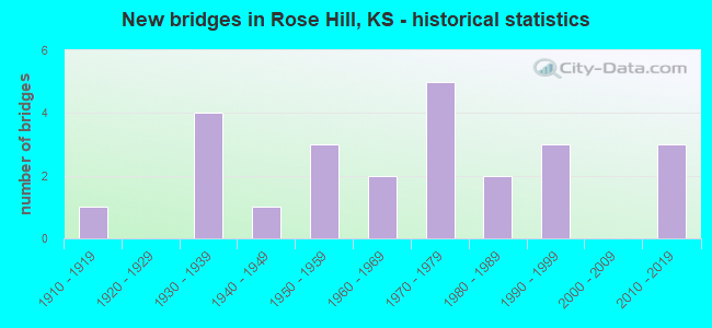
- New bridges - historical statistics
- 11910-1919
- 41930-1939
- 11940-1949
- 31950-1959
- 21960-1969
- 51970-1979
- 21980-1989
- 31990-1999
- 32010-2019
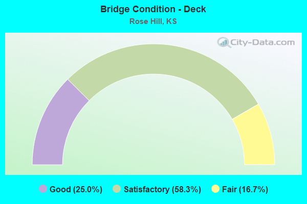
- Bridge Condition - Deck
- 25.0%Good
- 58.3%Satisfactory
- 16.7%Fair
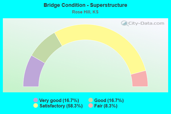
- Bridge Condition - Superstructure
- 16.7%Very good
- 16.7%Good
- 58.3%Satisfactory
- 8.3%Fair
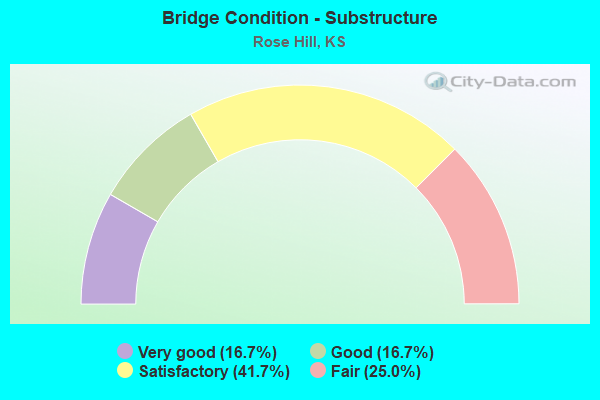
- Bridge Condition - Substructure
- 16.7%Very good
- 16.7%Good
- 41.7%Satisfactory
- 25.0%Fair
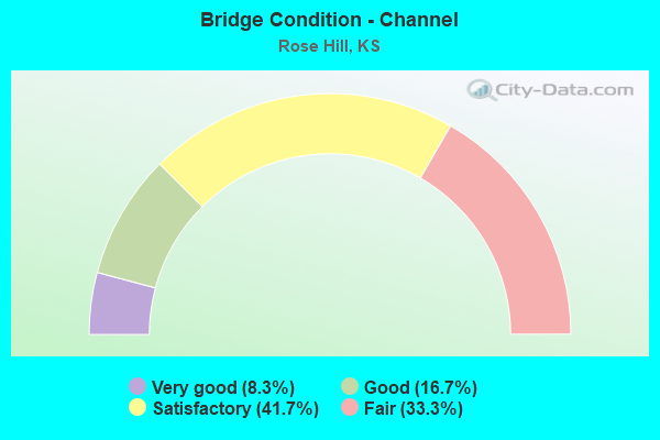
- Bridge Condition - Channel
- 8.3%Very good
- 16.7%Good
- 41.7%Satisfactory
- 33.3%Fair
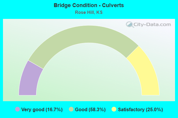
- Bridge Condition - Culverts
- 16.7%Very good
- 58.3%Good
- 25.0%Satisfactory
Find on map >> Show street view
Structure Number: 8051, Location: 3.0N 0.9W OF ROSEHILL (Lat: 37.606650, Lng: -97.150964), Route carried "on" structure: County highway 82, Year Built: 1941, Year Reconstructed: 1996, Status: Open, Structure Length: 0.62m (2.03ft), Average Daily Traffic: 4,400 (year 0000), Truck Traffic: 5%, Average Future Daily Traffic: 4,044 (year 2040), Design Load: H 15, Features Intersected: EIGHT MILE CREEK, Facility Carried by Structure: SW 150th
Minimum Vertical Clearance: 30.47m (99.97ft), Kilometerpoint: 0.000, Lanes on structure: 1, Owner: County Highway Agency, Approaching Roadway Width: 6.7m (22.0ft), Material/Design: Concrete, Design/Construction: Culvert, Number Of Spans In Main Unit: 2, Length of Maximum Span: 3.0m (9.8ft)
Condition: Channel: Satisfactory, Culverts: Good, Operating Rating: 25.9 metric tons, Method Used To Determine Operating Rating: Load Factor (LF), Inventory Rating: 15.5 metric tons, Method Used To Determine Inventory Rating: Load Factor (LF), Structural Evaluation: Meets minimum limits, Waterway Adequacy: Equal to present minimum criteria, Approach Roadway Alignment: Equal to present desirable criteria, Designated Inspection Frequency: Every 24 months, Inspection Date: January 2021
Find on map >> Show street view
Structure Number: 812, Location: 5.4W 0.0N DOUGLASS (Lat: 37.519361, Lng: -97.121339), Route carried "on" structure: County highway 89, Year Built: 2010, Status: Open, Structure Length: 1.31m (4.30ft), Average Daily Traffic: 2,110 (year 0000), Truck Traffic: 10%, Average Future Daily Traffic: 2,189 (year 2040), Design Load: HS 20, Features Intersected: TRIB TO POLECAT CREEK, Facility Carried by Structure: SW 210th
Minimum Vertical Clearance: 30.47m (99.97ft), Kilometerpoint: 0.000, Lanes on structure: 2, Owner: County Highway Agency, Approaching Roadway Width: 13.4m (44.0ft), Skew: 3 degrees, Material/Design: Concrete, Design/Construction: Culvert, Number Of Spans In Main Unit: 3, Length of Maximum Span: 4.2m (13.8ft), Curb-To-Curb Width: 21.9m (71.9ft), Out-to-Out Width: 22.3m (73.2ft)
Condition: Channel: Good, Culverts: Good, Operating Rating: 90.5 metric tons, Method Used To Determine Operating Rating: Load Factor (LF), Inventory Rating: 82.3 metric tons, Method Used To Determine Inventory Rating: Load Factor (LF), Structural Evaluation: Better than present minimum criteria, Deck Geometry: Superior to present desirable criteria, Waterway Adequacy: Equal to present minimum criteria, Approach Roadway Alignment: Equal to present desirable criteria, Designated Inspection Frequency: Every 24 months, Inspection Date: January 2021
Find on map >> Show street view
Structure Number: 8128, Location: 4.9W Douglass (Lat: 37.519367, Lng: -97.121511), Route carried "on" structure: County highway , Year Built: 2010, Status: Open, Structure Length: 0.75m (2.46ft), Average Daily Traffic: 1,900 (year 2019), Truck Traffic: 10%, Average Future Daily Traffic: 3,100 (year 2040), Design Load: HS 20, Features Intersected: Br. Polecat Creek, Facility Carried by Structure: SW 210th
Minimum Vertical Clearance: 30.47m (99.97ft), Kilometerpoint: 0.000, Lanes on structure: 2, Owner: County Highway Agency, Approaching Roadway Width: 12.1m (39.7ft), Material/Design: Concrete, Design/Construction: Culvert, Number Of Spans In Main Unit: 2, Length of Maximum Span: 3.7m (12.1ft), Curb-To-Curb Width: 21.9m (71.9ft), Out-to-Out Width: 22.4m (73.5ft)
Condition: Channel: Good, Culverts: Good, Inventory Rating: 11.1 metric tons, Method Used To Determine Inventory Rating: Load Factor (LF), Structural Evaluation: High priority of corrective action, Deck Geometry: Superior to present desirable criteria, Waterway Adequacy: Better than present minimum criteria, Approach Roadway Alignment: Equal to present desirable criteria, Designated Inspection Frequency: Every 24 months, Inspection Date: January 2021, Deck Structure Type: Concrete Cast-file-Place
Find on map >> Show street view
Structure Number: 87125, Location: 79thS, 0.3 E of 143rdE (Lat: 37.548383, Lng: -97.182667), Route carried "on" structure: County highway 81, Year Built: 1950, Status: Posted for load, Structure Length: 0.79m (2.59ft), Average Daily Traffic: 1,777 (year 2018), Truck Traffic: 2%, Average Future Daily Traffic: 2,168 (year 2038), Features Intersected: POLECAT CREEK
Minimum Vertical Clearance: 30.47m (99.97ft), Kilometerpoint: 0.000, Lanes on structure: 2, Owner: County Highway Agency, Approaching Roadway Width: 8.5m (27.9ft), Material/Design: Steel, Design/Construction: Stringer/Multi-beam, Number Of Spans In Main Unit: 1, Length of Maximum Span: 7.3m (24.0ft), Curb-To-Curb Width: 8.0m (26.2ft), Out-to-Out Width: 8.7m (28.5ft)
Condition: Deck: Satisfactory, Superstructure: Satisfactory, Substructure: Satisfactory, Channel: Fair, Operating Rating: 39.0 metric tons, Method Used To Determine Operating Rating: Load Factor (LF), Inventory Rating: 23.3 metric tons, Method Used To Determine Inventory Rating: Load Factor (LF), Structural Evaluation: Equal to present minimum criteria, Deck Geometry: Meets minimum limits, Waterway Adequacy: Equal to present minimum criteria, Approach Roadway Alignment: Equal to present minimum criteria, Designated Inspection Frequency: Every 24 months, Inspection Date: September 2020, Deck Structure Type: Concrete Cast-file-Place, Wearing Surface/Protective System: Wearing Surface: Bituminous
Find on map >> Show street view
Structure Number: 87126, Location: 79thS, 0.8 E of 143rdE (Lat: 37.548397, Lng: -97.156164), Route carried "on" structure: County highway 81, Year Built: 1950, Status: Posted for load, Structure Length: 1.04m (3.41ft), Average Daily Traffic: 1,777 (year 2018), Truck Traffic: 2%, Average Future Daily Traffic: 2,168 (year 2038), Features Intersected: TRIB. TO POLECAT CREEK
Minimum Vertical Clearance: 30.47m (99.97ft), Kilometerpoint: 0.000, Lanes on structure: 2, Owner: County Highway Agency, Approaching Roadway Width: 8.5m (27.9ft), Skew: 2 degrees, Material/Design: Steel, Design/Construction: Stringer/Multi-beam, Number Of Spans In Main Unit: 1, Length of Maximum Span: 9.4m (30.8ft), Curb-To-Curb Width: 8.1m (26.6ft), Out-to-Out Width: 8.7m (28.5ft)
Condition: Deck: Fair, Superstructure: Satisfactory, Substructure: Satisfactory, Channel: Fair, Operating Rating: 31.1 metric tons, Method Used To Determine Operating Rating: Load Factor (LF), Inventory Rating: 18.6 metric tons, Method Used To Determine Inventory Rating: Load Factor (LF), Structural Evaluation: Somewhat better than minimum adequacy, Deck Geometry: Meets minimum limits, Waterway Adequacy: Equal to present minimum criteria, Approach Roadway Alignment: Equal to present minimum criteria, Length Of Structure Improvement: 5.49m (18.01ft), Designated Inspection Frequency: Every 24 months, Inspection Date: September 2020, Bridge Improvement Cost: $650,000, Roadway Improvement Cost: $100,000, Total Project Cost: $750,000 ( Estimate for 2018), Deck Structure Type: Concrete Cast-file-Place, Wearing Surface/Protective System: Wearing Surface: Bituminous
Find on map >> Show street view
Structure Number: 80841006288, Location: 1.0W 3.2N OF ROSE HILL (Lat: 37.608942, Lng: -97.152992), Route carried "on" structure: County highway , Year Built: 1933, Status: Posted for load, Structure Length: 0.97m (3.18ft), Average Daily Traffic: 150 (year 2021), Truck Traffic: 1%, Average Future Daily Traffic: 150 (year 2040), Features Intersected: EIGHT MILE CREEK, Facility Carried by Structure: SW County Line Rd.
Minimum Vertical Clearance: 30.47m (99.97ft), Kilometerpoint: 0.000, Lanes on structure: 2, Owner: County Highway Agency, Approaching Roadway Width: 6.7m (22.0ft), Material/Design: Steel, Design/Construction: Stringer/Multi-beam, Number Of Spans In Main Unit: 1, Length of Maximum Span: 9.3m (30.5ft), Curb-To-Curb Width: 6.1m (20.0ft), Out-to-Out Width: 6.1m (20.0ft)
Condition: Deck: Satisfactory, Superstructure: Satisfactory, Substructure: Satisfactory, Channel: Satisfactory, Operating Rating: 12.7 metric tons, Method Used To Determine Operating Rating: Load Factor (LF), Inventory Rating: 7.4 metric tons, Method Used To Determine Inventory Rating: Load Factor (LF), Structural Evaluation: High priority of corrective action, Deck Geometry: Meets minimum limits, Waterway Adequacy: Equal to present minimum criteria, Approach Roadway Alignment: Equal to present desirable criteria, Bridge Posting: Required (Relationship of Operating Rating to Maximum Legal Load: > 39.9% below), Designated Inspection Frequency: Every 24 months, Inspection Date: January 2021, Deck Structure Type: Corrugated Steel, Wearing Surface/Protective System: Wearing Surface: Bituminous
Find on map >> Show street view
Structure Number: 80841006409, Location: 1.0W 3.0S OF ROSE HILL (Lat: 37.521128, Lng: -97.153033), Route carried "on" structure: County highway , Year Built: 1998, Status: Open, Structure Length: 0.64m (2.10ft), Average Daily Traffic: 75 (year 2021), Average Future Daily Traffic: 75 (year 2040), Design Load: HS 20, Features Intersected: SMALL STREAM, Facility Carried by Structure: SW County Line Rd.
Minimum Vertical Clearance: 30.47m (99.97ft), Kilometerpoint: 0.000, Lanes on structure: 2, Owner: County Highway Agency, Approaching Roadway Width: 7.0m (23.0ft), Material/Design: Concrete, Design/Construction: Culvert, Number Of Spans In Main Unit: 2, Length of Maximum Span: 3.0m (9.8ft), Curb-To-Curb Width: 8.5m (27.9ft), Out-to-Out Width: 9.0m (29.5ft)
Condition: Channel: Fair, Culverts: Good, Operating Rating: 70.2 metric tons, Method Used To Determine Operating Rating: Load Factor (LF), Inventory Rating: 42.1 metric tons, Method Used To Determine Inventory Rating: Load Factor (LF), Structural Evaluation: Better than present minimum criteria, Deck Geometry: Better than present minimum criteria, Waterway Adequacy: Somewhat better than minimum adequacy, Approach Roadway Alignment: Equal to present desirable criteria, Designated Inspection Frequency: Every 24 months, Inspection Date: January 2021
Find on map >> Show street view
Structure Number: 8084170642, Location: 2.0S 0.3W OF ROSE HILL (Lat: 37.519314, Lng: -97.140597), Route carried "on" structure: County highway 802, Year Built: 1980, Status: Posted for load, Structure Length: 3.70m (12.14ft), Average Daily Traffic: 1,000 (year 0000), Truck Traffic: 1%, Average Future Daily Traffic: 1,000 (year 2040), Design Load: H 20, Features Intersected: POLE CAT CREEK, Facility Carried by Structure: SW 210th
Minimum Vertical Clearance: 30.47m (99.97ft), Kilometerpoint: 0.000, Lanes on structure: 2, Owner: County Highway Agency, Approaching Roadway Width: 7.3m (24.0ft), Material/Design: Prestressed concrete continuous, Design/Construction: Tee Beam, Number Of Spans In Main Unit: 3, Length of Maximum Span: 12.2m (40.0ft), Curb-To-Curb Width: 9.1m (29.9ft), Out-to-Out Width: 9.7m (31.8ft)
Condition: Deck: Good, Superstructure: Good, Substructure: Good, Channel: Satisfactory, Operating Rating: 24.7 metric tons, Method Used To Determine Operating Rating: Load Factor (LF), Inventory Rating: 14.8 metric tons, Method Used To Determine Inventory Rating: Load Factor (LF), Structural Evaluation: Meets minimum limits, Deck Geometry: Equal to present minimum criteria, Waterway Adequacy: Equal to present desirable criteria, Approach Roadway Alignment: Equal to present desirable criteria, Bridge Posting: Required (Relationship of Operating Rating to Maximum Legal Load: > 39.9% below), Designated Inspection Frequency: Every 24 months, Inspection Date: January 2021, Deck Structure Type: Concrete Cast-file-Place, Wearing Surface/Protective System: Wearing Surface: Integral Concrete
Find on map >> Show street view
Structure Number: 8084190632, Location: 2.0N OF ROSE HILL (Lat: 37.592244, Lng: -97.137536), Route carried "on" structure: County highway , Year Built: 1963, Status: Open, Structure Length: 1.31m (4.30ft), Average Daily Traffic: 150 (year 2021), Truck Traffic: 1%, Average Future Daily Traffic: 150 (year 2040), Features Intersected: EIGHT MILE CREEK, Facility Carried by Structure: SW 160th
Minimum Vertical Clearance: 30.47m (99.97ft), Kilometerpoint: 0.000, Lanes on structure: 2, Owner: County Highway Agency, Approaching Roadway Width: 7.3m (24.0ft), Material/Design: Concrete, Design/Construction: Culvert, Number Of Spans In Main Unit: 4, Length of Maximum Span: 3.0m (9.8ft), Curb-To-Curb Width: 9.1m (29.9ft), Out-to-Out Width: 9.8m (32.2ft)
Condition: Channel: Fair, Culverts: Good, Operating Rating: 50.8 metric tons, Method Used To Determine Operating Rating: Load Factor (LF), Inventory Rating: 30.5 metric tons, Method Used To Determine Inventory Rating: Load Factor (LF), Structural Evaluation: Better than present minimum criteria, Deck Geometry: Equal to present minimum criteria, Waterway Adequacy: Equal to present minimum criteria, Approach Roadway Alignment: Equal to present desirable criteria, Designated Inspection Frequency: Every 24 months, Inspection Date: January 2021
Find on map >> Show street view
Structure Number: 8084320632, Location: 0.2E 2.0N OF ROSE HILL (Lat: 37.592292, Lng: -97.130775), Route carried "on" structure: County highway , Year Built: 1936, Status: Posted for load, Structure Length: 0.80m (2.62ft), Average Daily Traffic: 125 (year 0000), Truck Traffic: 1%, Average Future Daily Traffic: 125 (year 2040), Features Intersected: SMALL STREAM, Facility Carried by Structure: SW 160th
Minimum Vertical Clearance: 30.47m (99.97ft), Kilometerpoint: 0.000, Lanes on structure: 2, Owner: County Highway Agency, Approaching Roadway Width: 6.7m (22.0ft), Material/Design: Steel, Design/Construction: Stringer/Multi-beam, Number Of Spans In Main Unit: 1, Length of Maximum Span: 7.9m (25.9ft), Curb-To-Curb Width: 7.2m (23.6ft), Out-to-Out Width: 7.3m (24.0ft)
Condition: Deck: Satisfactory, Superstructure: Satisfactory, Substructure: Satisfactory, Channel: Fair, Operating Rating: 23.5 metric tons, Method Used To Determine Operating Rating: Load Factor (LF), Inventory Rating: 14.1 metric tons, Method Used To Determine Inventory Rating: Load Factor (LF), Structural Evaluation: Meets minimum limits, Deck Geometry: Meets minimum limits, Waterway Adequacy: Equal to present minimum criteria, Approach Roadway Alignment: Equal to present desirable criteria, Bridge Posting: Required (Relationship of Operating Rating to Maximum Legal Load: 10.0 - 19.9% below), Designated Inspection Frequency: Every 24 months, Inspection Date: January 2021, Deck Structure Type: Corrugated Steel, Wearing Surface/Protective System: Wearing Surface: Bituminous
Find on map >> Show street view
Structure Number: 808437064, Location: 0.7E 2.0S OF ROSE HILL (Lat: 37.533983, Lng: -97.122594), Route carried "on" structure: County highway , Year Built: 1934, Status: Open, Structure Length: 0.88m (2.89ft), Average Daily Traffic: 75 (year 2021), Average Future Daily Traffic: 75 (year 2040), Features Intersected: POLE CAT CREEK, Facility Carried by Structure: SW 200th
Minimum Vertical Clearance: 30.47m (99.97ft), Kilometerpoint: 0.000, Lanes on structure: 2, Owner: County Highway Agency, Approaching Roadway Width: 7.0m (23.0ft), Material/Design: Concrete continuous, Design/Construction: Slab, Number Of Spans In Main Unit: 3, Length of Maximum Span: 2.4m (7.9ft), Curb-To-Curb Width: 7.3m (24.0ft), Out-to-Out Width: 8.1m (26.6ft)
Condition: Deck: Satisfactory, Superstructure: Satisfactory, Substructure: Satisfactory, Channel: Satisfactory, Operating Rating: 31.7 metric tons, Method Used To Determine Operating Rating: Load Factor (LF), Inventory Rating: 19.0 metric tons, Method Used To Determine Inventory Rating: Load Factor (LF), Structural Evaluation: Somewhat better than minimum adequacy, Deck Geometry: Equal to present minimum criteria, Waterway Adequacy: Equal to present minimum criteria, Approach Roadway Alignment: Equal to present desirable criteria, Designated Inspection Frequency: Every 24 months, Inspection Date: January 2021, Deck Structure Type: Concrete Cast-file-Place, Wearing Surface/Protective System: Wearing Surface: Gravel
Find on map >> Show street view
Structure Number: 8084390644, Location: 4.0S 0.9E OF ROSE HILL (Lat: 37.504789, Lng: -97.120175), Route carried "on" structure: County highway , Year Built: 1994, Status: Open, Structure Length: 3.47m (11.38ft), Average Daily Traffic: 25 (year 0000), Average Future Daily Traffic: 25 (year 2040), Design Load: HS 20, Features Intersected: POLECAT CREEK, Facility Carried by Structure: SW 220th
Minimum Vertical Clearance: 30.47m (99.97ft), Kilometerpoint: 0.000, Lanes on structure: 2, Owner: County Highway Agency, Approaching Roadway Width: 6.7m (22.0ft), Skew: 3 degrees, Material/Design: Concrete continuous, Design/Construction: Slab, Number Of Spans In Main Unit: 3, Length of Maximum Span: 13.7m (44.9ft), Curb-To-Curb Width: 8.5m (27.9ft), Out-to-Out Width: 9.1m (29.9ft)
Condition: Deck: Good, Superstructure: Very good, Substructure: Very good, Channel: Satisfactory, Operating Rating: 80.1 metric tons, Method Used To Determine Operating Rating: Load Factor (LF), Inventory Rating: 47.7 metric tons, Method Used To Determine Inventory Rating: Load Factor (LF), Structural Evaluation: Equal to present desirable criteria, Deck Geometry: Better than present minimum criteria, Waterway Adequacy: Better than present minimum criteria, Approach Roadway Alignment: Equal to present desirable criteria, Designated Inspection Frequency: Every 24 months, Inspection Date: January 2021, Deck Structure Type: Concrete Cast-file-Place, Wearing Surface/Protective System: Wearing Surface: Monolithic Concrete
Find on map >> Show street view
Structure Number: 80845006327, Location: 1.0E 1.3N OF ROSE HILL (Lat: 37.579989, Lng: -97.116911), Route carried "on" structure: County highway , Year Built: 1975, Status: Posted for load, Structure Length: 0.73m (2.40ft), Average Daily Traffic: 175 (year 2021), Truck Traffic: 1%, Average Future Daily Traffic: 175 (year 2040), Features Intersected: EIGHT MILE CREEK, Facility Carried by Structure: SW Prairie Crk Rd.
Minimum Vertical Clearance: 30.47m (99.97ft), Kilometerpoint: 0.000, Lanes on structure: 2, Owner: County Highway Agency, Approaching Roadway Width: 6.1m (20.0ft), Material/Design: Steel, Design/Construction: Stringer/Multi-beam, Number Of Spans In Main Unit: 1, Length of Maximum Span: 7.0m (23.0ft), Curb-To-Curb Width: 6.1m (20.0ft), Out-to-Out Width: 6.1m (20.0ft)
Condition: Deck: Satisfactory, Superstructure: Satisfactory, Substructure: Fair, Channel: Fair, Operating Rating: 14.0 metric tons, Method Used To Determine Operating Rating: Load Factor (LF), Inventory Rating: 8.4 metric tons, Method Used To Determine Inventory Rating: Load Factor (LF), Structural Evaluation: High priority of corrective action, Deck Geometry: Meets minimum limits, Waterway Adequacy: Meets minimum limits, Approach Roadway Alignment: Equal to present minimum criteria, Bridge Posting: Required (Relationship of Operating Rating to Maximum Legal Load: > 39.9% below), Designated Inspection Frequency: Every 24 months, Inspection Date: January 2021, Deck Structure Type: Corrugated Steel, Wearing Surface/Protective System: Wearing Surface: Integral Concrete
Find on map >> Show street view
Structure Number: 80845006329, Location: 1.0E 1.1N OF ROSE HILL (Lat: 37.578167, Lng: -97.116867), Route carried "on" structure: County highway , Year Built: 1979, Status: Open, Structure Length: 0.80m (2.62ft), Average Daily Traffic: 175 (year 2021), Truck Traffic: 1%, Average Future Daily Traffic: 175 (year 2040), Design Load: H 20, Features Intersected: SMALL STREAM, Facility Carried by Structure: SW Prairie Crk Rd.
Minimum Vertical Clearance: 30.47m (99.97ft), Kilometerpoint: 0.000, Lanes on structure: 2, Owner: County Highway Agency, Approaching Roadway Width: 7.3m (24.0ft), Skew: 4 degrees, Material/Design: Concrete, Design/Construction: Culvert, Number Of Spans In Main Unit: 2, Length of Maximum Span: 4.1m (13.5ft), Curb-To-Curb Width: 9.1m (29.9ft), Out-to-Out Width: 9.6m (31.5ft)
Condition: Channel: Good, Culverts: Good, Operating Rating: 40.0 metric tons, Method Used To Determine Operating Rating: Load Factor (LF), Inventory Rating: 24.0 metric tons, Method Used To Determine Inventory Rating: Load Factor (LF), Structural Evaluation: Equal to present minimum criteria, Deck Geometry: Equal to present minimum criteria, Waterway Adequacy: Equal to present minimum criteria, Approach Roadway Alignment: Equal to present desirable criteria, Designated Inspection Frequency: Every 24 months, Inspection Date: January 2021
Find on map >> Show street view
Structure Number: 8084530632, Location: 1.3E 2.0N OF ROSE HILL (Lat: 37.592225, Lng: -97.111622), Route carried "on" structure: County highway , Year Built: 1958, Status: Open, Structure Length: 0.76m (2.49ft), Average Daily Traffic: 175 (year 2021), Truck Traffic: 1%, Average Future Daily Traffic: 175 (year 2040), Design Load: H 15, Features Intersected: SMALL STREAM, Facility Carried by Structure: SW 160th
Minimum Vertical Clearance: 30.47m (99.97ft), Kilometerpoint: 0.000, Lanes on structure: 2, Owner: County Highway Agency, Approaching Roadway Width: 6.7m (22.0ft), Material/Design: Concrete, Design/Construction: Culvert, Number Of Spans In Main Unit: 3, Length of Maximum Span: 2.4m (7.9ft), Curb-To-Curb Width: 9.1m (29.9ft), Out-to-Out Width: 9.8m (32.2ft)
Condition: Channel: Satisfactory, Culverts: Satisfactory, Operating Rating: 27.3 metric tons, Method Used To Determine Operating Rating: Load Factor (LF), Inventory Rating: 16.3 metric tons, Method Used To Determine Inventory Rating: Load Factor (LF), Structural Evaluation: Somewhat better than minimum adequacy, Deck Geometry: Equal to present minimum criteria, Waterway Adequacy: Equal to present minimum criteria, Approach Roadway Alignment: Equal to present desirable criteria, Bridge Posting: Required (Relationship of Operating Rating to Maximum Legal Load: 20.0 - 29.9% below), Designated Inspection Frequency: Every 24 months, Inspection Date: January 2021, Wearing Surface/Protective System: Wearing Surface: Gravel
Find on map >> Show street view
Structure Number: 8084710634, Location: 2.1E 1.0N OF ROSE HILL (Lat: 37.577750, Lng: -97.098489), Route carried "on" structure: County highway , Year Built: 1986, Status: Open, Structure Length: 1.55m (5.09ft), Average Daily Traffic: 150 (year 2021), Truck Traffic: 1%, Average Future Daily Traffic: 150 (year 2040), Design Load: H 15, Features Intersected: EIGHT MILE CREEK, Facility Carried by Structure: SW 170th
Minimum Vertical Clearance: 30.47m (99.97ft), Kilometerpoint: 0.000, Lanes on structure: 2, Owner: County Highway Agency, Approaching Roadway Width: 6.7m (22.0ft), Material/Design: Steel, Design/Construction: Girder and Floorbeam System, Number Of Spans In Main Unit: 1, Length of Maximum Span: 14.9m (48.9ft), Curb-To-Curb Width: 8.1m (26.6ft), Out-to-Out Width: 8.3m (27.2ft)
Condition: Deck: Good, Superstructure: Very good, Substructure: Very good, Channel: Satisfactory, Operating Rating: 37.2 metric tons, Method Used To Determine Operating Rating: Load Factor (LF), Inventory Rating: 22.2 metric tons, Method Used To Determine Inventory Rating: Load Factor (LF), Structural Evaluation: Equal to present minimum criteria, Deck Geometry: Somewhat better than minimum adequacy, Waterway Adequacy: Better than present minimum criteria, Approach Roadway Alignment: Somewhat better than minimum adequacy, Designated Inspection Frequency: Every 24 months, Critical Feature Inspection Frequency: Every 24 months, Inspection Date: January 2021, Critical Feature Inspection Date: June 2021, Deck Structure Type: Corrugated Steel, Wearing Surface/Protective System: Wearing Surface: Monolithic Concrete
Find on map >> Show street view
Structure Number: 8084770636, Location: 2.7E OF ROSE HILL (Lat: 37.563003, Lng: -97.085267), Route carried "on" structure: County highway 804, Year Built: 1934, Status: Posted for load, Structure Length: 2.56m (8.40ft), Average Daily Traffic: 200 (year 2021), Truck Traffic: 2%, Average Future Daily Traffic: 300 (year 2040), Features Intersected: EIGHT MILE CREEK, Facility Carried by Structure: SW 180th
Minimum Vertical Clearance: 30.47m (99.97ft), Kilometerpoint: 0.000, Lanes on structure: 2, Owner: County Highway Agency, Approaching Roadway Width: 5.7m (18.7ft), Material/Design: Steel, Design/Construction: Truss - Thru, Number Of Spans In Main Unit: 1, Number Of Approach Spans: 1, Length of Maximum Span: 18.3m (60.0ft), Curb-To-Curb Width: 6.1m (20.0ft), Out-to-Out Width: 6.5m (21.3ft)
Condition: Deck: Satisfactory, Superstructure: Satisfactory, Substructure: Good, Channel: Satisfactory, Operating Rating: 29.4 metric tons, Method Used To Determine Operating Rating: Load Factor (LF), Inventory Rating: 17.6 metric tons, Method Used To Determine Inventory Rating: Load Factor (LF), Structural Evaluation: Somewhat better than minimum adequacy, Deck Geometry: Meets minimum limits, Waterway Adequacy: Better than present minimum criteria, Approach Roadway Alignment: Better than present minimum criteria, Designated Inspection Frequency: Every 24 months, Critical Feature Inspection Frequency: Every 24 months, Inspection Date: January 2021, Critical Feature Inspection Date: June 2021, Deck Structure Type: Concrete Cast-file-Place, Wearing Surface/Protective System: Wearing Surface: Monolithic Concrete
Find on map >> Show street view
Structure Number: 80849006363, Location: 3.0E 0.3S OF ROSE HILL (Lat: 37.558878, Lng: -97.080344), Route carried "on" structure: County highway , Year Built: 1918, Status: Open, Structure Length: 1.07m (3.51ft), Average Daily Traffic: 175 (year 0000), Truck Traffic: 1%, Average Future Daily Traffic: 175 (year 2040), Features Intersected: EIGHT MILE CREEK, Facility Carried by Structure: SW Indianola Rd.
Minimum Vertical Clearance: 30.47m (99.97ft), Kilometerpoint: 0.000, Lanes on structure: 2, Owner: County Highway Agency, Approaching Roadway Width: 6.4m (21.0ft), Material/Design: Concrete, Design/Construction: Tee Beam, Number Of Spans In Main Unit: 1, Length of Maximum Span: 10.4m (34.1ft), Curb-To-Curb Width: 5.0m (16.4ft), Out-to-Out Width: 5.5m (18.0ft)
Condition: Deck: Fair, Superstructure: Fair, Substructure: Fair, Channel: Fair, Operating Rating: 34.8 metric tons, Method Used To Determine Operating Rating: Load Factor (LF), Inventory Rating: 20.9 metric tons, Method Used To Determine Inventory Rating: Load Factor (LF), Structural Evaluation: Somewhat better than minimum adequacy, Deck Geometry: High priority of replacement, Waterway Adequacy: Equal to present minimum criteria, Approach Roadway Alignment: Equal to present desirable criteria, Length Of Structure Improvement: 1.07m (3.51ft), Designated Inspection Frequency: Every 24 months, Inspection Date: January 2021, Bridge Improvement Cost: $60,000, Roadway Improvement Cost: $8,000, Total Project Cost: $75,000, Deck Structure Type: Concrete Cast-file-Place, Wearing Surface/Protective System: Wearing Surface: Monolithic Concrete
Find on map >> Show street view
Structure Number: 8084950638, Location: 3.5W 2.0N OF DOUGLASS (Lat: 37.548436, Lng: -97.072614), Route carried "on" structure: County highway , Year Built: 1970, Status: Posted for load, Structure Length: 1.08m (3.54ft), Average Daily Traffic: 125 (year 2021), Truck Traffic: 1%, Average Future Daily Traffic: 125 (year 2040), Features Intersected: EIGHT MILE CREEK, Facility Carried by Structure: SW 190th
Minimum Vertical Clearance: 30.47m (99.97ft), Kilometerpoint: 0.000, Lanes on structure: 2, Owner: County Highway Agency, Approaching Roadway Width: 7.5m (24.6ft), Material/Design: Steel, Design/Construction: Stringer/Multi-beam, Number Of Spans In Main Unit: 1, Length of Maximum Span: 10.4m (34.1ft), Curb-To-Curb Width: 5.9m (19.4ft), Out-to-Out Width: 6.2m (20.3ft)
Condition: Deck: Satisfactory, Superstructure: Good, Substructure: Fair, Channel: Fair, Operating Rating: 8.2 metric tons, Method Used To Determine Operating Rating: Load Factor (LF), Inventory Rating: 4.9 metric tons, Method Used To Determine Inventory Rating: Load Factor (LF), Structural Evaluation: High priority of corrective action, Deck Geometry: High priority of corrective action, Waterway Adequacy: Equal to present minimum criteria, Approach Roadway Alignment: Equal to present desirable criteria, Bridge Posting: Required (Relationship of Operating Rating to Maximum Legal Load: > 39.9% below), Length Of Structure Improvement: 1.34m (4.40ft), Designated Inspection Frequency: Every 24 months, Inspection Date: January 2021, Bridge Improvement Cost: $57,000, Roadway Improvement Cost: $6,000, Total Project Cost: $86,000, Deck Structure Type: Corrugated Steel, Wearing Surface/Protective System: Wearing Surface: Bituminous
Find on map >> Show street view
Structure Number: 870839006346, Location: 143rd E, 0.3 N of 71st S (Lat: 37.567939, Lng: -97.171111), Route carried "on" structure: County highway 2485, Year Built: 2016, Status: Open, Structure Length: 2.28m (7.48ft), Average Daily Traffic: 779 (year 2018), Truck Traffic: 12%, Average Future Daily Traffic: 950 (year 2038), Design Load: HL 93, Features Intersected: TRIB. TO POLECAT CREEK, Facility Carried by Structure: LOCAL RD 143rd E
Minimum Vertical Clearance: 30.47m (99.97ft), Kilometerpoint: 0.000, Lanes on structure: 2, Owner: County Highway Agency, Approaching Roadway Width: 6.7m (22.0ft), Skew: 4 degrees, Material/Design: Concrete, Design/Construction: Culvert, Number Of Spans In Main Unit: 5, Length of Maximum Span: 4.3m (14.1ft), Curb-To-Curb Width: 15.9m (52.2ft), Out-to-Out Width: 16.3m (53.5ft)
Condition: Channel: Very good, Culverts: Very good, Operating Rating: 43.5 metric tons, Method Used To Determine Operating Rating: Load and Resistance Factor (LRFR), Inventory Rating: 32.7 metric tons, Method Used To Determine Inventory Rating: Load and Resistance Factor (LRFR), Structural Evaluation: Equal to present desirable criteria, Deck Geometry: Superior to present desirable criteria, Waterway Adequacy: Equal to present desirable criteria, Approach Roadway Alignment: Equal to present desirable criteria, Designated Inspection Frequency: Every 24 months, Inspection Date: September 2020, Deck Structure Type: Concrete Cast-file-Place, Wearing Surface/Protective System: Wearing Surface: Bituminous, Deck Protection: Epoxy Coated Reinforcing
Find on map >> Show street view
Structure Number: 870839006366, Location: 143rdE, 0.4 N of 79thS (Lat: 37.554347, Lng: -97.171164), Route carried "on" structure: County highway , Year Built: 1970, Status: Posted for load, Structure Length: 0.82m (2.69ft), Average Daily Traffic: 631 (year 2018), Truck Traffic: 5%, Average Future Daily Traffic: 770 (year 2038), Features Intersected: POLECAT CREEK, Facility Carried by Structure: 143rd
Minimum Vertical Clearance: 30.47m (99.97ft), Kilometerpoint: 0.000, Lanes on structure: 2, Owner: County Highway Agency, Approaching Roadway Width: 7.8m (25.6ft), Material/Design: Steel, Design/Construction: Culvert, Number Of Spans In Main Unit: 3, Length of Maximum Span: 2.7m (8.9ft), Curb-To-Curb Width: 7.9m (25.9ft), Out-to-Out Width: 7.9m (25.9ft)
Condition: Channel: Satisfactory, Culverts: Satisfactory, Operating Rating: 27.4 metric tons, Method Used To Determine Operating Rating: Load Factor (LF), Inventory Rating: 16.3 metric tons, Method Used To Determine Inventory Rating: Load Factor (LF), Structural Evaluation: Meets minimum limits, Deck Geometry: Somewhat better than minimum adequacy, Waterway Adequacy: Equal to present minimum criteria, Approach Roadway Alignment: Equal to present minimum criteria, Bridge Posting: Required (Relationship of Operating Rating to Maximum Legal Load: 20.0 - 29.9% below), Designated Inspection Frequency: Every 24 months, Inspection Date: September 2020, Deck Structure Type: Other, Wearing Surface/Protective System: Wearing Surface: Bituminous
Find on map >> Show street view
Structure Number: 870839006369, Location: 143rdE, 0.04 N of 79thS (Lat: 37.548889, Lng: -97.171111), Route carried "on" structure: County highway , Year Built: 1992, Status: Open, Structure Length: 0.76m (2.49ft), Average Daily Traffic: 631 (year 2018), Truck Traffic: 5%, Average Future Daily Traffic: 770 (year 2038), Design Load: HS 20, Features Intersected: TRIB. TO POLECAT CREEK, Facility Carried by Structure: 143rd
Minimum Vertical Clearance: 30.47m (99.97ft), Kilometerpoint: 0.000, Lanes on structure: 2, Owner: County Highway Agency, Approaching Roadway Width: 8.5m (27.9ft), Material/Design: Concrete, Design/Construction: Culvert, Number Of Spans In Main Unit: 3, Length of Maximum Span: 2.4m (7.9ft), Curb-To-Curb Width: 8.5m (27.9ft), Out-to-Out Width: 9.0m (29.5ft)
Condition: Channel: Good, Culverts: Very good, Operating Rating: 64.2 metric tons, Method Used To Determine Operating Rating: Load Factor (LF), Inventory Rating: 38.5 metric tons, Method Used To Determine Inventory Rating: Load Factor (LF), Structural Evaluation: Equal to present desirable criteria, Deck Geometry: Somewhat better than minimum adequacy, Waterway Adequacy: Equal to present desirable criteria, Approach Roadway Alignment: Better than present minimum criteria, Designated Inspection Frequency: Every 24 months, Inspection Date: September 2020, Other Special Inspection Date: Febuary 2021, Deck Structure Type: Concrete Cast-file-Place, Wearing Surface/Protective System: Wearing Surface: Bituminous
Find on map >> Show street view
Structure Number: 87083950636, Location: 71stS, 0.5 E of 143rdE (Lat: 37.562928, Lng: -97.178947), Route carried "on" structure: County highway , Year Built: 1968, Status: Open, Structure Length: 1.31m (4.30ft), Average Daily Traffic: 50 (year 2018), Average Future Daily Traffic: 80 (year 2038), Features Intersected: POLECAT CREEK, Facility Carried by Structure: 71st
Minimum Vertical Clearance: 30.47m (99.97ft), Kilometerpoint: 0.000, Lanes on structure: 2, Owner: County Highway Agency, Approaching Roadway Width: 7.5m (24.6ft), Material/Design: Concrete, Design/Construction: Culvert, Number Of Spans In Main Unit: 4, Length of Maximum Span: 3.4m (11.2ft), Curb-To-Curb Width: 10.9m (35.8ft), Out-to-Out Width: 11.4m (37.4ft)
Condition: Channel: Satisfactory, Culverts: Good, Operating Rating: 22.5 metric tons, Method Used To Determine Operating Rating: Load Factor (LF), Inventory Rating: 17.1 metric tons, Method Used To Determine Inventory Rating: Load Factor (LF), Structural Evaluation: Somewhat better than minimum adequacy, Deck Geometry: Superior to present desirable criteria, Waterway Adequacy: Better than present minimum criteria, Approach Roadway Alignment: Equal to present desirable criteria, Designated Inspection Frequency: Every 24 months, Inspection Date: September 2020, Deck Structure Type: Concrete Cast-file-Place, Wearing Surface/Protective System: Wearing Surface: Gravel
Find on map >> Show street view
Structure Number: 870839706365, Location: 75thS, 0.7 E of 143rdE (Lat: 37.555667, Lng: -97.176058), Route carried "on" structure: County highway , Year Built: 1978, Status: Open, Structure Length: 1.65m (5.41ft), Average Daily Traffic: 50 (year 2018), Average Future Daily Traffic: 80 (year 2038), Features Intersected: POLECAT CREEK, Facility Carried by Structure: 75th
Minimum Vertical Clearance: 30.47m (99.97ft), Kilometerpoint: 0.000, Lanes on structure: 2, Owner: County Highway Agency, Approaching Roadway Width: 7.8m (25.6ft), Material/Design: Concrete, Design/Construction: Culvert, Number Of Spans In Main Unit: 5, Length of Maximum Span: 3.4m (11.2ft), Curb-To-Curb Width: 9.7m (31.8ft), Out-to-Out Width: 10.2m (33.5ft)
Condition: Channel: Very good, Culverts: Satisfactory, Operating Rating: 22.5 metric tons, Method Used To Determine Operating Rating: Load Factor (LF), Inventory Rating: 17.1 metric tons, Method Used To Determine Inventory Rating: Load Factor (LF), Structural Evaluation: Somewhat better than minimum adequacy, Deck Geometry: Better than present minimum criteria, Waterway Adequacy: Better than present minimum criteria, Approach Roadway Alignment: Equal to present desirable criteria, Designated Inspection Frequency: Every 24 months, Inspection Date: September 2020, Deck Structure Type: Concrete Cast-file-Place, Wearing Surface/Protective System: Wearing Surface: Gravel