Bridge Statistics for Roseland, New Jersey (NJ)
Condition, Traffic, Stress, Structural Evaluation, Project Costs
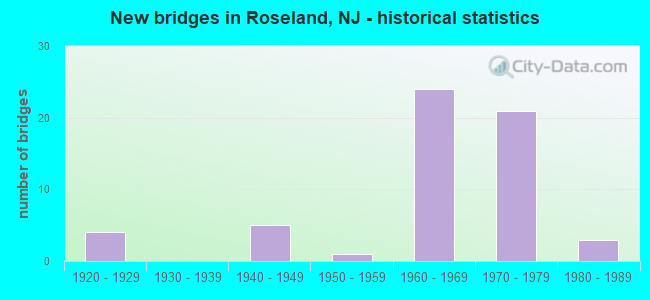
- New bridges - historical statistics
- 41920-1929
- 51940-1949
- 11950-1959
- 241960-1969
- 211970-1979
- 31980-1989
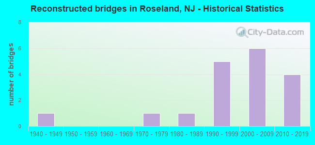
- Reconstructed bridges - Historical Statistics
- 11940-1949
- 01950-1959
- 01960-1969
- 11970-1979
- 11980-1989
- 51990-1999
- 62000-2009
- 42010-2019

- Bridge Condition - Deck
- 2.7%Excellent
- 8.1%Very good
- 21.6%Good
- 40.5%Satisfactory
- 13.5%Fair
- 13.5%Poor
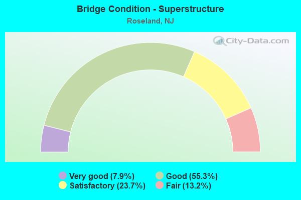
- Bridge Condition - Superstructure
- 7.9%Very good
- 55.3%Good
- 23.7%Satisfactory
- 13.2%Fair
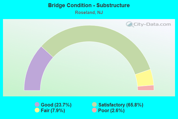
- Bridge Condition - Substructure
- 23.7%Good
- 65.8%Satisfactory
- 7.9%Fair
- 2.6%Poor
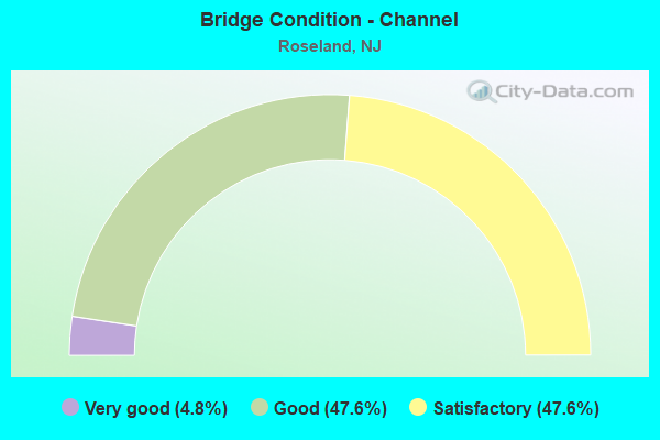
- Bridge Condition - Channel
- 4.8%Very good
- 47.6%Good
- 47.6%Satisfactory
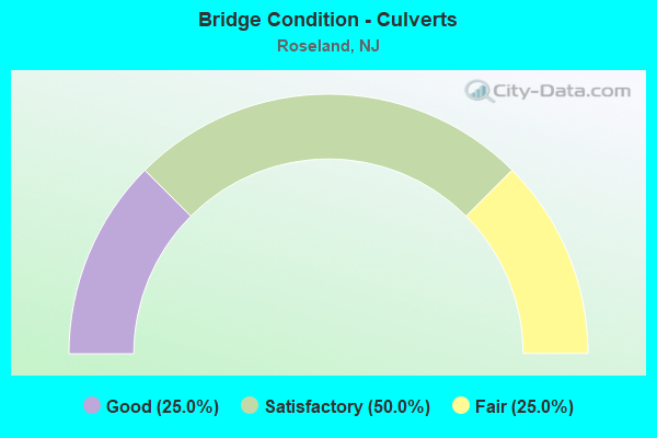
- Bridge Condition - Culverts
- 25.0%Good
- 50.0%Satisfactory
- 25.0%Fair
Find on map >> Show street view
Structure Number: 700015, Location: 0.11 miles north of CR611 (Lat: 40.822381, Lng: -74.324939), Route carried "on" structure: County highway 609, Year Built: 1973, Year Reconstructed: 2010, Status: Open, Structure Length: 0.76m (2.49ft), Average Daily Traffic: 26,905 (year 2021), Truck Traffic: 4%, Average Future Daily Traffic: 32,265 (year 2041), Design Load: HS 20, Features Intersected: S. Br. of Foulerton's Br, Facility Carried by Structure: Eisenhower Pkwy
Minimum Vertical Clearance: 30+ m (98+ ft), Kilometerpoint: 6.180, Lanes on structure: 4, Base Highway Network: Yes, Owner: County Highway Agency, Approaching Roadway Width: 20.2m (66.3ft), Skew: 20 degrees, Material/Design: Concrete, Design/Construction: Slab, Number Of Spans In Main Unit: 1, Length of Maximum Span: 7.3m (24.0ft), Curb or Sidewalk Widths: Left: 2.7m (8.9ft), Right: 2.7m (8.9ft), Curb-To-Curb Width: 20.2m (66.3ft), Out-to-Out Width: 30.5m (100.1ft)
Condition: Deck: Good, Superstructure: Good, Substructure: Satisfactory, Channel: Good, Operating Rating: 89.8 metric tons, Method Used To Determine Operating Rating: Load Factor (LF), Inventory Rating: 53.5 metric tons, Method Used To Determine Inventory Rating: Load Factor (LF), Structural Evaluation: Equal to present minimum criteria, Deck Geometry: Better than present minimum criteria, Waterway Adequacy: Equal to present desirable criteria, Approach Roadway Alignment: Equal to present desirable criteria, Designated Inspection Frequency: Every 24 months, Inspection Date: August 2021, Deck Structure Type: Concrete Cast-file-Place, Wearing Surface/Protective System: Wearing Surface: Monolithic Concrete, Deck Protection: Epoxy Coated Reinforcing
Find on map >> Show street view
Structure Number: 700091, Location: 0.46 MI. East of I-280 (Lat: 40.820839, Lng: -74.306850), Route carried "on" structure: County highway 611, Year Built: 1980, Status: Open, Structure Length: 0.67m (2.20ft), Average Daily Traffic: 10,317 (year 2019), Truck Traffic: 4%, Average Future Daily Traffic: 12,380 (year 2039), Design Load: HS 20, Features Intersected: Foulerton's Brook, Facility Carried by Structure: Eagle Rock Avenue
Minimum Vertical Clearance: 30+ m (98+ ft), Kilometerpoint: 7.838, Lanes on structure: 4, Owner: County Highway Agency, Approaching Roadway Width: 18.3m (60.0ft), Material/Design: Concrete, Design/Construction: Culvert, Number Of Spans In Main Unit: 1, Length of Maximum Span: 6.7m (22.0ft), Curb or Sidewalk Widths: Left: 0.0m, Right: 2.3m (7.5ft), Curb-To-Curb Width: 18.3m (60.0ft), Out-to-Out Width: 26.1m (85.6ft)
Condition: Channel: Good, Culverts: Satisfactory, Operating Rating: 37.2 metric tons, Method Used To Determine Operating Rating: Load Factor (LF), Inventory Rating: 21.8 metric tons, Method Used To Determine Inventory Rating: Load Factor (LF), Structural Evaluation: Somewhat better than minimum adequacy, Deck Geometry: Somewhat better than minimum adequacy, Waterway Adequacy: Equal to present minimum criteria, Approach Roadway Alignment: Better than present minimum criteria, Designated Inspection Frequency: Every 24 months, Inspection Date: August 2021
Find on map >> Show street view
Structure Number: 700092, Location: 0.16 miles east of CR 611 (Lat: 40.818581, Lng: -74.305700), Route carried "on" structure: City street , Year Built: 1980, Status: Open, Structure Length: 0.61m (2.00ft), Average Daily Traffic: 8,219 (year 2021), Truck Traffic: 3%, Average Future Daily Traffic: 9,863 (year 2041), Design Load: HS 20, Features Intersected: Foulerton's Brook, Facility Carried by Structure: Becker Farm Road
Minimum Vertical Clearance: 30+ m (98+ ft), Kilometerpoint: 0.257, Lanes on structure: 5, Owner: County Highway Agency, Approaching Roadway Width: 19.9m (65.3ft), Material/Design: Concrete, Design/Construction: Culvert, Number Of Spans In Main Unit: 1, Length of Maximum Span: 6.1m (20.0ft), Curb or Sidewalk Widths: Left: 1.2m (3.9ft), Right: 0.0m, Curb-To-Curb Width: 19.9m (65.3ft), Out-to-Out Width: 31.7m (104.0ft)
Condition: Channel: Very good, Culverts: Fair, Operating Rating: 40.8 metric tons, Method Used To Determine Operating Rating: Load Factor (LF), Inventory Rating: 24.9 metric tons, Method Used To Determine Inventory Rating: Load Factor (LF), Structural Evaluation: Somewhat better than minimum adequacy, Deck Geometry: Meets minimum limits, Waterway Adequacy: Better than present minimum criteria, Approach Roadway Alignment: Equal to present desirable criteria, Designated Inspection Frequency: Every 24 months, Inspection Date: August 2021
Find on map >> Show street view
Structure Number: 700093, Location: 900 FT NW. OF RT 527 (Lat: 40.817511, Lng: -74.303031), Route carried "on" structure: City street , Year Built: 1979, Status: Open, Structure Length: 0.61m (2.00ft), Average Daily Traffic: 2,757 (year 2021), Truck Traffic: 1%, Average Future Daily Traffic: 3,388 (year 2041), Design Load: H 20, Features Intersected: Foulerton's Brook, Facility Carried by Structure: ADP Boulevard
Minimum Vertical Clearance: 30+ m (98+ ft), Kilometerpoint: 0.000, Lanes on structure: 3, Owner: County Highway Agency, Approaching Roadway Width: 13.7m (44.9ft), Skew: 1 degrees, Material/Design: Concrete, Design/Construction: Culvert, Number Of Spans In Main Unit: 1, Length of Maximum Span: 6.1m (20.0ft), Curb or Sidewalk Widths: Left: 1.2m (3.9ft), Right: 0.0m, Curb-To-Curb Width: 13.7m (44.9ft), Out-to-Out Width: 26.2m (86.0ft)
Condition: Channel: Good, Culverts: Satisfactory, Operating Rating: 84.4 metric tons, Method Used To Determine Operating Rating: Load Factor (LF), Inventory Rating: 49.9 metric tons, Method Used To Determine Inventory Rating: Load Factor (LF), Structural Evaluation: Equal to present minimum criteria, Deck Geometry: Somewhat better than minimum adequacy, Waterway Adequacy: Better than present minimum criteria, Approach Roadway Alignment: Equal to present desirable criteria, Designated Inspection Frequency: Every 24 months, Inspection Date: August 2021
Find on map >> Show street view
Structure Number: 70025A, Location: .46 M.N OF 280/527 INTER. (Lat: 40.816189, Lng: -74.301731), Route carried "on" structure: County highway 527, Year Built: 1975, Year Reconstructed: 1979, Status: Open, Structure Length: 0.79m (2.59ft), Average Daily Traffic: 13,386 (year 2020), Truck Traffic: 4%, Average Future Daily Traffic: 16,331 (year 2040), Design Load: HS 20, Features Intersected: FOULERTON BROOK, Facility Carried by Structure: N. LIVINGSTON AV
Minimum Vertical Clearance: 30+ m (98+ ft), Kilometerpoint: 126.543, Lanes on structure: 8, Owner: County Highway Agency, Approaching Roadway Width: 34.1m (111.9ft), Skew: 20 degrees, Material/Design: Prestressed concrete, Design/Construction: Slab, Number Of Spans In Main Unit: 1, Length of Maximum Span: 7.0m (23.0ft), Curb or Sidewalk Widths: Left: 3.2m (10.5ft), Right: 2.5m (8.2ft), Curb-To-Curb Width: 34.1m (111.9ft), Out-to-Out Width: 40.4m (132.5ft)
Condition: Deck: Fair, Superstructure: Satisfactory, Substructure: Satisfactory, Channel: Satisfactory, Operating Rating: 55.3 metric tons, Method Used To Determine Operating Rating: Load Factor (LF), Inventory Rating: 33.6 metric tons, Method Used To Determine Inventory Rating: Load Factor (LF), Structural Evaluation: Equal to present minimum criteria, Deck Geometry: Equal to present minimum criteria, Waterway Adequacy: Equal to present minimum criteria, Approach Roadway Alignment: Equal to present desirable criteria, Designated Inspection Frequency: Every 24 months, Inspection Date: August 2020, Deck Structure Type: Concrete Precast Panels, Wearing Surface/Protective System: Wearing Surface: Bituminous, Membrane: Other
Find on map >> Show street view
Structure Number: 72815, Location: 0.05MI E OF 280-Pass R JT (Lat: 40.829939, Lng: -74.328939), Route carried "on" structure: Interstate 280, Year Built: 1972, Status: Open, Structure Length: 1.80m (5.91ft), Average Daily Traffic: 40,110 (year 2020), Truck Traffic: 9%, Average Future Daily Traffic: 47,960 (year 2020), Design Load: HS 20, Features Intersected: Proposed Essex CO.PK.RD
Minimum Vertical Clearance: 30.45m (99.90ft), Kilometerpoint: 5.423, Lanes on structure: 2, Base Highway Network: Yes, Owner: State Highway Agency, Approaching Roadway Width: 11.9m (39.0ft), Material/Design: Steel, Design/Construction: Stringer/Multi-beam, Number Of Spans In Main Unit: 1, Length of Maximum Span: 16.8m (55.1ft), Curb-To-Curb Width: 11.9m (39.0ft), Out-to-Out Width: 13.4m (44.0ft)
Condition: Deck: Poor, Superstructure: Good, Substructure: Good, Operating Rating: 87.1 metric tons, Method Used To Determine Operating Rating: Load Factor (LF), Inventory Rating: 51.7 metric tons, Method Used To Determine Inventory Rating: Load Factor (LF), Structural Evaluation: Better than present minimum criteria, Deck Geometry: Equal to present minimum criteria, Approach Roadway Alignment: Equal to present desirable criteria, Length Of Structure Improvement: 1.80m (5.91ft), Designated Inspection Frequency: Every 24 months, Inspection Date: May 2020, Bridge Improvement Cost: $621,000, Roadway Improvement Cost: $85,000, Total Project Cost: $812,000 ( Estimate for 2020), Deck Structure Type: Concrete Cast-file-Place, Wearing Surface/Protective System: Wearing Surface: Bituminous
Find on map >> Show street view
Structure Number: 728151, Location: 0.2 MI E OF 280-PSSC R JT (Lat: 40.830131, Lng: -74.328600), Route carried "on" structure: Interstate 280, Year Built: 1972, Year Reconstructed: 2018, Status: Open, Structure Length: 1.83m (6.00ft), Average Daily Traffic: 38,180 (year 2020), Truck Traffic: 9%, Average Future Daily Traffic: 52,580 (year 2040), Design Load: HL 93, Features Intersected: PROPOSED ESSEX CO.PK.RD.
Minimum Vertical Clearance: 30+ m (98+ ft), Kilometerpoint: 5.423, Lanes on structure: 2, Base Highway Network: Yes, Owner: State Highway Agency, Approaching Roadway Width: 12.4m (40.7ft), Material/Design: Steel, Design/Construction: Stringer/Multi-beam, Number Of Spans In Main Unit: 1, Length of Maximum Span: 16.8m (55.1ft), Curb-To-Curb Width: 12.4m (40.7ft), Out-to-Out Width: 13.5m (44.3ft)
Condition: Deck: Excellent, Superstructure: Good, Substructure: Good, Operating Rating: 75.8 metric tons, Method Used To Determine Operating Rating: Load and Resistance Factor Rating (LRFR) rating reported by rating factor(RF) method using HL-93 loadings, Inventory Rating: 71.0 metric tons, Method Used To Determine Inventory Rating: Load and Resistance Factor Rating (LRFR) rating reported by rating factor(RF) method using HL-93 loadings, Structural Evaluation: Better than present minimum criteria, Deck Geometry: Better than present minimum criteria, Approach Roadway Alignment: Equal to present desirable criteria, Length Of Structure Improvement: 1.80m (5.91ft), Designated Inspection Frequency: Every 24 months, Inspection Date: May 2020, Bridge Improvement Cost: $454,000, Roadway Improvement Cost: $45,000, Total Project Cost: $550,000 ( Estimate for 2016), Deck Structure Type: Concrete Cast-file-Place, Wearing Surface/Protective System: Deck Protection: Epoxy Coated Reinforcing
Find on map >> Show street view
Structure Number: 728152, Location: AT I-280 EXIT 4 (Lat: 40.825150, Lng: -74.321461), Route carried "on" structure: County highway 609, Year Built: 1970, Year Reconstructed: 1996, Status: Open, Structure Length: 6.61m (21.69ft), Average Daily Traffic: 23,340 (year 2021), Truck Traffic: 4%, Average Future Daily Traffic: 28,010 (year 2041), Design Load: HS 20+Mod, Features Intersected: I-280, Facility Carried by Structure: EISENHOWER PKWY
Minimum Vertical Clearance: 30+ m (98+ ft), Kilometerpoint: 6.630, Lanes on structure: 4, Lanes under structure: 7, Base Highway Network: Yes, Owner: State Highway Agency, Approaching Roadway Width: 23.2m (76.1ft), Skew: 20 degrees, Material/Design: Steel, Design/Construction: Stringer/Multi-beam, Number Of Spans In Main Unit: 2, Length of Maximum Span: 32.0m (105.0ft), Curb or Sidewalk Widths: Left: 0.5m (1.6ft), Right: 0.5m (1.6ft), Curb-To-Curb Width: 23.2m (76.1ft), Out-to-Out Width: 29.0m (95.1ft)
Condition: Deck: Satisfactory, Superstructure: Good, Substructure: Fair, Operating Rating: 64.4 metric tons, Method Used To Determine Operating Rating: Load Factor (LF), Inventory Rating: 38.1 metric tons, Method Used To Determine Inventory Rating: Load Factor (LF), Structural Evaluation: Somewhat better than minimum adequacy, Deck Geometry: Superior to present desirable criteria, Underclear: Meets minimum limits, Approach Roadway Alignment: Better than present minimum criteria, Designated Inspection Frequency: Every 24 months, Inspection Date: March 2021, Deck Structure Type: Concrete Cast-file-Place, Wearing Surface/Protective System: Wearing Surface: Latex Concrete
Find on map >> Show street view
Structure Number: 728155, Location: 0.24 Miles East of Exit 4 (Lat: 40.822811, Lng: -74.318639), Route carried "on" structure: Interstate 280, Year Built: 1970, Year Reconstructed: 2008, Status: Open, Structure Length: 3.54m (11.61ft), Average Daily Traffic: 40,764 (year 2020), Truck Traffic: 9%, Average Future Daily Traffic: 57,065 (year 2040), Design Load: HL 93, Features Intersected: Passaic Avenue (CR 613)
Minimum Vertical Clearance: 30+ m (98+ ft), Kilometerpoint: 6.614, Lanes on structure: 4, Lanes under structure: 2, Base Highway Network: Yes, Owner: State Highway Agency, Approaching Roadway Width: 17.4m (57.1ft), Skew: 1 degrees, Material/Design: Steel, Design/Construction: Stringer/Multi-beam, Number Of Spans In Main Unit: 1, Length of Maximum Span: 35.1m (115.2ft), Curb-To-Curb Width: 16.3m (53.5ft), Out-to-Out Width: 17.4m (57.1ft)
Condition: Deck: Good, Superstructure: Good, Substructure: Satisfactory, Operating Rating: 33.7 metric tons, Method Used To Determine Operating Rating: Load and Resistance Factor Rating (LRFR) rating reported by rating factor(RF) method using HL-93 loadings, Inventory Rating: 25.9 metric tons, Method Used To Determine Inventory Rating: Load and Resistance Factor Rating (LRFR) rating reported by rating factor(RF) method using HL-93 loadings, Structural Evaluation: Equal to present minimum criteria, Deck Geometry: High priority of replacement, Underclear: Equal to present minimum criteria, Approach Roadway Alignment: Better than present minimum criteria, Length Of Structure Improvement: 3.54m (11.61ft), Designated Inspection Frequency: Every 24 months, Inspection Date: April 2020, Bridge Improvement Cost: $377,000, Roadway Improvement Cost: $103,000, Total Project Cost: $648,000 ( Estimate for 2020), Deck Structure Type: Concrete Precast Panels, Wearing Surface/Protective System: Wearing Surface: Bituminous, Membrane: Other, Deck Protection: Epoxy Coated Reinforcing
Find on map >> Show street view
Structure Number: 728156, Location: 0.8 MI E OF 280-PSSC R JT (Lat: 40.823111, Lng: -74.318231), Route carried "on" structure: Interstate 280, Year Built: 1968, Status: Open, Structure Length: 3.20m (10.50ft), Average Daily Traffic: 82,730 (year 2020), Truck Traffic: 9%, Average Future Daily Traffic: 99,276 (year 2040), Design Load: HS 20, Features Intersected: PASSAIC AVE (CO RT 613)
Minimum Vertical Clearance: 30+ m (98+ ft), Kilometerpoint: 6.614, Lanes on structure: 3, Lanes under structure: 2, Base Highway Network: Yes, Owner: State Highway Agency, Approaching Roadway Width: 15.5m (50.9ft), Skew: 1 degrees, Material/Design: Steel, Design/Construction: Stringer/Multi-beam, Number Of Spans In Main Unit: 1, Length of Maximum Span: 30.8m (101.0ft), Curb or Sidewalk Widths: Left: 0.5m (1.6ft), Right: 0.5m (1.6ft), Curb-To-Curb Width: 15.5m (50.9ft), Out-to-Out Width: 17.1m (56.1ft)
Condition: Deck: Satisfactory, Superstructure: Satisfactory, Substructure: Satisfactory, Operating Rating: 50.8 metric tons, Method Used To Determine Operating Rating: Load Factor (LF), Inventory Rating: 29.9 metric tons, Method Used To Determine Inventory Rating: Load Factor (LF), Structural Evaluation: Equal to present minimum criteria, Deck Geometry: Somewhat better than minimum adequacy, Underclear: Meets minimum limits, Approach Roadway Alignment: Equal to present desirable criteria, Designated Inspection Frequency: Every 24 months, Inspection Date: July 2020, Deck Structure Type: Concrete Cast-file-Place, Wearing Surface/Protective System: Wearing Surface: Latex Concrete
Find on map >> Show street view
Structure Number: 728157, Location: 0.4 Mile East of CR 609 (Lat: 40.820781, Lng: -74.317150), Route carried "on" structure: Interstate 280, Year Built: 1968, Year Reconstructed: 2006, Status: Open, Structure Length: 3.41m (11.19ft), Average Daily Traffic: 41,150 (year 2021), Truck Traffic: 9%, Average Future Daily Traffic: 49,380 (year 2041), Design Load: HS 25 or greater, Features Intersected: MORRISTOWN & ERIE RR
Minimum Vertical Clearance: 30+ m (98+ ft), Kilometerpoint: 6.872, Lanes on structure: 3, Base Highway Network: Yes, Owner: State Highway Agency, Approaching Roadway Width: 15.5m (50.9ft), Material/Design: Steel, Design/Construction: Stringer/Multi-beam, Number Of Spans In Main Unit: 3, Length of Maximum Span: 12.2m (40.0ft), Curb-To-Curb Width: 16.1m (52.8ft), Out-to-Out Width: 17.1m (56.1ft)
Condition: Deck: Good, Superstructure: Good, Substructure: Satisfactory, Inventory Rating: 72.6 metric tons, Method Used To Determine Inventory Rating: Load Factor (LF), Structural Evaluation: Equal to present minimum criteria, Deck Geometry: Equal to present minimum criteria, Underclear: Meets minimum limits, Approach Roadway Alignment: Equal to present desirable criteria, Designated Inspection Frequency: Every 24 months, Inspection Date: March 2021, Deck Structure Type: Concrete Precast Panels, Wearing Surface/Protective System: Deck Protection: Epoxy Coated Reinforcing
Find on map >> Show street view
Structure Number: 728158, Location: 0.7 MI. WEST OF CR 527 (Lat: 40.820889, Lng: -74.316819), Route carried "on" structure: Interstate 280, Year Built: 1968, Year Reconstructed: 1997, Status: Open, Structure Length: 3.41m (11.19ft), Average Daily Traffic: 41,150 (year 2021), Truck Traffic: 9%, Average Future Daily Traffic: 49,380 (year 2041), Design Load: HS 20+Mod, Features Intersected: MORRISTOWN & ERIE RR
Minimum Vertical Clearance: 30+ m (98+ ft), Kilometerpoint: 6.872, Lanes on structure: 3, Base Highway Network: Yes, Owner: State Highway Agency, Approaching Roadway Width: 15.5m (50.9ft), Material/Design: Steel, Design/Construction: Stringer/Multi-beam, Number Of Spans In Main Unit: 3, Length of Maximum Span: 12.2m (40.0ft), Curb or Sidewalk Widths: Left: 0.5m (1.6ft), Right: 0.5m (1.6ft), Curb-To-Curb Width: 15.5m (50.9ft), Out-to-Out Width: 17.1m (56.1ft)
Condition: Deck: Satisfactory, Superstructure: Satisfactory, Substructure: Satisfactory, Operating Rating: 76.2 metric tons, Method Used To Determine Operating Rating: Load Factor (LF), Inventory Rating: 45.4 metric tons, Method Used To Determine Inventory Rating: Load Factor (LF), Structural Evaluation: Equal to present minimum criteria, Deck Geometry: Somewhat better than minimum adequacy, Underclear: Meets minimum limits, Approach Roadway Alignment: Equal to present desirable criteria, Designated Inspection Frequency: Every 24 months, Inspection Date: March 2021, Deck Structure Type: Concrete Cast-file-Place, Wearing Surface/Protective System: Wearing Surface: Latex Concrete
Find on map >> Show street view
Structure Number: 728159, Location: 0.5 MI WEST OF CR 527 (Lat: 40.818689, Lng: -74.315681), Route carried "on" structure: Interstate 280, Year Built: 1968, Year Reconstructed: 2007, Status: Open, Structure Length: 3.93m (12.89ft), Average Daily Traffic: 40,400 (year 2021), Truck Traffic: 9%, Average Future Daily Traffic: 48,500 (year 2041), Design Load: HS 20+Mod, Features Intersected: (CR 611) EAGLE ROCK AVE
Minimum Vertical Clearance: 30+ m (98+ ft), Kilometerpoint: 7.145, Lanes on structure: 3, Lanes under structure: 4, Base Highway Network: Yes, Owner: State Highway Agency, Approaching Roadway Width: 15.5m (50.9ft), Skew: 2 degrees, Material/Design: Steel, Design/Construction: Stringer/Multi-beam, Number Of Spans In Main Unit: 3, Length of Maximum Span: 21.9m (71.9ft), Curb-To-Curb Width: 16.1m (52.8ft), Out-to-Out Width: 17.1m (56.1ft)
Condition: Deck: Good, Superstructure: Fair, Substructure: Satisfactory, Inventory Rating: 56.2 metric tons, Method Used To Determine Inventory Rating: Load Factor (LF), Structural Evaluation: Somewhat better than minimum adequacy, Deck Geometry: Equal to present minimum criteria, Underclear: Meets minimum limits, Approach Roadway Alignment: Equal to present desirable criteria, Designated Inspection Frequency: Every 24 months, Inspection Date: March 2021, Deck Structure Type: Other, Wearing Surface/Protective System: Wearing Surface: Bituminous, Membrane: Other, Deck Protection: Epoxy Coated Reinforcing
Find on map >> Show street view
Structure Number: 72816, Location: 0.57 MI E OF I-280 EXIT 4 (Lat: 40.818581, Lng: -74.315081), Route carried "on" structure: Interstate I-280, Year Built: 1968, Status: Open, Structure Length: 3.90m (12.80ft), Average Daily Traffic: 81,079 (year 2020), Truck Traffic: 9%, Average Future Daily Traffic: 97,294 (year 2040), Design Load: HS 20, Features Intersected: Eagle Rock Ave. (CR 611)
Minimum Vertical Clearance: 30+ m (98+ ft), Kilometerpoint: 7.145, Lanes on structure: 3, Lanes under structure: 4, Base Highway Network: Yes, Owner: State Highway Agency, Approaching Roadway Width: 15.5m (50.9ft), Skew: 2 degrees, Material/Design: Steel, Design/Construction: Stringer/Multi-beam, Number Of Spans In Main Unit: 3, Length of Maximum Span: 20.7m (67.9ft), Curb or Sidewalk Widths: Left: 0.5m (1.6ft), Right: 0.5m (1.6ft), Curb-To-Curb Width: 15.5m (50.9ft), Out-to-Out Width: 17.1m (56.1ft)
Condition: Deck: Satisfactory, Superstructure: Good, Substructure: Satisfactory, Operating Rating: 89.8 metric tons, Method Used To Determine Operating Rating: Load Factor (LF), Inventory Rating: 89.8 metric tons, Method Used To Determine Inventory Rating: Load Factor (LF), Structural Evaluation: Equal to present minimum criteria, Deck Geometry: Somewhat better than minimum adequacy, Underclear: High priority of corrective action, Approach Roadway Alignment: Equal to present desirable criteria, Designated Inspection Frequency: Every 24 months, Inspection Date: April 2020, Roadway Improvement Cost: $29,000, Total Project Cost: $35,000 ( Estimate for 2020), Deck Structure Type: Concrete Cast-file-Place, Wearing Surface/Protective System: Wearing Surface: Monolithic Concrete
Find on map >> Show street view
Structure Number: 72915, Location: AT I-280/CR 527 JCT (Lat: 40.812969, Lng: -74.309569), Route carried "on" structure: Interstate 280, Year Built: 1968, Status: Open, Structure Length: 5.24m (17.19ft), Average Daily Traffic: 41,150 (year 2021), Truck Traffic: 9%, Average Future Daily Traffic: 49,380 (year 2041), Design Load: HS 20+Mod, Features Intersected: LIVINGSTON AVE (CR 527)
Minimum Vertical Clearance: 30+ m (98+ ft), Kilometerpoint: 7.966, Lanes on structure: 4, Lanes under structure: 6, Base Highway Network: Yes, Owner: State Highway Agency, Approaching Roadway Width: 15.8m (51.8ft), Skew: 2 degrees, Material/Design: Steel, Design/Construction: Stringer/Multi-beam, Number Of Spans In Main Unit: 2, Length of Maximum Span: 26.5m (86.9ft), Curb or Sidewalk Widths: Left: 0.5m (1.6ft), Right: 0.5m (1.6ft), Curb-To-Curb Width: 15.8m (51.8ft), Out-to-Out Width: 17.4m (57.1ft)
Condition: Deck: Fair, Superstructure: Good, Substructure: Satisfactory, Operating Rating: 58.1 metric tons, Method Used To Determine Operating Rating: Load Factor (LF), Inventory Rating: 34.5 metric tons, Method Used To Determine Inventory Rating: Load Factor (LF), Structural Evaluation: Equal to present minimum criteria, Deck Geometry: High priority of replacement, Underclear: Equal to present minimum criteria, Approach Roadway Alignment: Equal to present desirable criteria, Length Of Structure Improvement: 5.24m (17.19ft), Designated Inspection Frequency: Every 24 months, Inspection Date: March 2021, Bridge Improvement Cost: $774,000, Roadway Improvement Cost: $50,000, Total Project Cost: $1,160,000 ( Estimate for 2021), Deck Structure Type: Concrete Cast-file-Place
Find on map >> Show street view
Structure Number: 729151, Location: AT I-280/CR 527 JCT (Lat: 40.813131, Lng: -74.309239), Route carried "on" structure: Interstate 280, Year Built: 1968, Status: Open, Structure Length: 5.30m (17.39ft), Average Daily Traffic: 41,150 (year 2021), Truck Traffic: 9%, Average Future Daily Traffic: 49,380 (year 2041), Design Load: HS 20+Mod, Features Intersected: LIVINGSTON AVE (CR 527)
Minimum Vertical Clearance: 30+ m (98+ ft), Kilometerpoint: 7.966, Lanes on structure: 4, Lanes under structure: 6, Base Highway Network: Yes, Owner: State Highway Agency, Approaching Roadway Width: 15.8m (51.8ft), Skew: 2 degrees, Material/Design: Steel, Design/Construction: Stringer/Multi-beam, Number Of Spans In Main Unit: 2, Length of Maximum Span: 26.5m (86.9ft), Curb or Sidewalk Widths: Left: 0.5m (1.6ft), Right: 0.5m (1.6ft), Curb-To-Curb Width: 15.8m (51.8ft), Out-to-Out Width: 17.4m (57.1ft)
Condition: Deck: Satisfactory, Superstructure: Good, Substructure: Satisfactory, Operating Rating: 44.5 metric tons, Method Used To Determine Operating Rating: Load Factor (LF), Inventory Rating: 26.3 metric tons, Method Used To Determine Inventory Rating: Load Factor (LF), Structural Evaluation: Equal to present minimum criteria, Deck Geometry: High priority of replacement, Underclear: Equal to present minimum criteria, Approach Roadway Alignment: Equal to present desirable criteria, Length Of Structure Improvement: 5.30m (17.39ft), Designated Inspection Frequency: Every 24 months, Inspection Date: March 2021, Bridge Improvement Cost: $783,000, Roadway Improvement Cost: $50,000, Total Project Cost: $1,173,000 ( Estimate for 2021), Deck Structure Type: Concrete Cast-file-Place
Find on map >> Show street view
Structure Number: 729152, Location: AT I-280-CR 634 JCT (Lat: 40.806681, Lng: -74.287281), Route carried "on" structure: County highway 634, Year Built: 1968, Status: Open, Structure Length: 6.61m (21.69ft), Average Daily Traffic: 13,600 (year 2021), Truck Traffic: 4%, Average Future Daily Traffic: 16,300 (year 2041), Design Load: HS 20+Mod, Features Intersected: I-280
Minimum Vertical Clearance: 30+ m (98+ ft), Kilometerpoint: 1.593, Lanes on structure: 2, Lanes under structure: 8, Owner: State Highway Agency, Approaching Roadway Width: 14.0m (45.9ft), Skew: 1 degrees, Material/Design: Steel, Design/Construction: Stringer/Multi-beam, Number Of Spans In Main Unit: 2, Length of Maximum Span: 32.0m (105.0ft), Curb or Sidewalk Widths: Left: 1.8m (5.9ft), Right: 1.8m (5.9ft), Curb-To-Curb Width: 14.0m (45.9ft), Out-to-Out Width: 18.3m (60.0ft)
Condition: Deck: Fair, Superstructure: Fair, Substructure: Satisfactory, Operating Rating: 57.2 metric tons, Method Used To Determine Operating Rating: Load Factor (LF), Inventory Rating: 33.6 metric tons, Method Used To Determine Inventory Rating: Load Factor (LF), Structural Evaluation: Somewhat better than minimum adequacy, Deck Geometry: Superior to present desirable criteria, Underclear: High priority of corrective action, Approach Roadway Alignment: Equal to present desirable criteria, Length Of Structure Improvement: 6.61m (21.69ft), Designated Inspection Frequency: Every 24 months, Inspection Date: March 2021, Bridge Improvement Cost: $835,000, Roadway Improvement Cost: $170,000, Total Project Cost: $1,326,000 ( Estimate for 2021), Deck Structure Type: Concrete Cast-file-Place
Find on map >> Show street view
Structure Number: 1400431, Location: 1MI E OF I-80 & I-280 JCT (Lat: 40.859061, Lng: -74.348139), Route carried "on" structure: City street , Year Built: 1922, Status: Open, Structure Length: 1.31m (4.30ft), Average Daily Traffic: 12,995 (year 2021), Truck Traffic: 3%, Average Future Daily Traffic: 15,856 (year 2041), Design Load: H 20, Features Intersected: TRIB TO ROCKAWAY RIVER, Facility Carried by Structure: OLD BLOOMFIELD AVE
Minimum Vertical Clearance: 30+ m (98+ ft), Kilometerpoint: 2.543, Lanes on structure: 2, Owner: County Highway Agency, Approaching Roadway Width: 8.8m (28.9ft), Material/Design: Concrete, Design/Construction: Arch - Deck, Number Of Spans In Main Unit: 1, Length of Maximum Span: 13.1m (43.0ft), Curb-To-Curb Width: 8.9m (29.2ft), Out-to-Out Width: 10.0m (32.8ft)
Condition: Superstructure: Fair, Substructure: Satisfactory, Channel: Satisfactory, Operating Rating: 38.1 metric tons, Method Used To Determine Operating Rating: Field evaluation and documented engineering judgment, Inventory Rating: 22.7 metric tons, Method Used To Determine Inventory Rating: Field evaluation and documented engineering judgment, Structural Evaluation: Somewhat better than minimum adequacy, Deck Geometry: High priority of replacement, Waterway Adequacy: Superior to present desirable criteria, Approach Roadway Alignment: Equal to present desirable criteria, Length Of Structure Improvement: 1.31m (4.30ft), Designated Inspection Frequency: Every 24 months, Inspection Date: July 2021, Bridge Improvement Cost: $638,000, Roadway Improvement Cost: $160,000, Total Project Cost: $1,595,000 ( Estimate for 2021)
Find on map >> Show street view
Structure Number: 1400432, Location: 1MI E OF I-80 & I-280 JCT (Lat: 40.859031, Lng: -74.347400), Route carried "on" structure: City street , Year Built: 1921, Year Reconstructed: 1993, Status: Open, Structure Length: 2.41m (7.91ft), Average Daily Traffic: 12,995 (year 2021), Truck Traffic: 3%, Average Future Daily Traffic: 15,856 (year 2041), Design Load: HS 20+Mod, Features Intersected: ROCKAWAY RIVER, Facility Carried by Structure: OLD BLOOMFIELD AVE
Minimum Vertical Clearance: 30+ m (98+ ft), Kilometerpoint: 2.607, Lanes on structure: 2, Owner: County Highway Agency, Approaching Roadway Width: 9.8m (32.2ft), Material/Design: Prestressed concrete, Design/Construction: Box Beam or Girders - Multiple, Number Of Spans In Main Unit: 1, Length of Maximum Span: 22.6m (74.1ft), Curb-To-Curb Width: 9.9m (32.5ft), Out-to-Out Width: 11.0m (36.1ft)
Condition: Deck: Satisfactory, Superstructure: Good, Substructure: Satisfactory, Channel: Satisfactory, Operating Rating: 77.1 metric tons, Method Used To Determine Operating Rating: Load Factor (LF), Inventory Rating: 46.3 metric tons, Method Used To Determine Inventory Rating: Load Factor (LF), Structural Evaluation: Equal to present minimum criteria, Deck Geometry: Meets minimum limits, Waterway Adequacy: Superior to present desirable criteria, Approach Roadway Alignment: Equal to present desirable criteria, Designated Inspection Frequency: Every 24 months, Inspection Date: July 2021, Deck Structure Type: Concrete Cast-file-Place, Wearing Surface/Protective System: Wearing Surface: Monolithic Concrete, Deck Protection: Epoxy Coated Reinforcing
Find on map >> Show street view
Structure Number: 1400433, Location: 0.09 MI. NORTH OF US 46 (Lat: 40.859831, Lng: -74.327789), Route carried "on" structure: City street , Year Built: 1921, Status: Posted for load, Structure Length: 3.75m (12.30ft), Average Daily Traffic: 322 (year 2021), Truck Traffic: 1%, Average Future Daily Traffic: 386 (year 2041), Features Intersected: BRANCH OFPASSAIC RIVER, Facility Carried by Structure: OLD BLOOMFIELD AVE
Minimum Vertical Clearance: 30+ m (98+ ft), Kilometerpoint: 0.000, Lanes on structure: 2, Owner: County Highway Agency, Approaching Roadway Width: 9.1m (29.9ft), Material/Design: Steel, Design/Construction: Stringer/Multi-beam, Number Of Spans In Main Unit: 4, Length of Maximum Span: 8.8m (28.9ft), Curb-To-Curb Width: 9.3m (30.5ft), Out-to-Out Width: 10.0m (32.8ft)
Condition: Deck: Poor, Superstructure: Fair, Substructure: Fair, Channel: Satisfactory, Operating Rating: 35.4 metric tons, Method Used To Determine Operating Rating: Load Factor (LF), Inventory Rating: 20.9 metric tons, Method Used To Determine Inventory Rating: Load Factor (LF), Structural Evaluation: Somewhat better than minimum adequacy, Deck Geometry: Equal to present minimum criteria, Waterway Adequacy: Better than present minimum criteria, Approach Roadway Alignment: Better than present minimum criteria, Length Of Structure Improvement: 3.75m (12.30ft), Designated Inspection Frequency: Every 24 months, Other Special Inspection Frequency: Every 12 months, Inspection Date: August 2021, Other Special Inspection Date: August 2021, Bridge Improvement Cost: $1,134,000, Roadway Improvement Cost: $56,000, Total Project Cost: $1,717,000 ( Estimate for 2021), Deck Structure Type: Concrete Cast-file-Place, Wearing Surface/Protective System: Wearing Surface: Bituminous
Find on map >> Show street view
Structure Number: 1400443, Location: 0.6MI NW CR609&CR611 JCT (Lat: 40.827631, Lng: -74.335181), Route carried "on" structure: County highway 611, Year Built: 1952, Year Reconstructed: 2015, Status: Open, Structure Length: 5.12m (16.80ft), Average Daily Traffic: 19,022 (year 2021), Truck Traffic: 4%, Average Future Daily Traffic: 23,210 (year 2041), Design Load: HL 93, Features Intersected: PASSAIC RIVER
Minimum Vertical Clearance: 30+ m (98+ ft), Kilometerpoint: 0.000, Lanes on structure: 3, Owner: County Highway Agency, Approaching Roadway Width: 12.2m (40.0ft), Skew: 2 degrees, Material/Design: Prestressed concrete, Design/Construction: Box Beam or Girders - Multiple, Number Of Spans In Main Unit: 2, Length of Maximum Span: 24.4m (80.1ft), Curb or Sidewalk Widths: Left: 1.6m (5.2ft), Right: 1.6m (5.2ft), Curb-To-Curb Width: 12.2m (40.0ft), Out-to-Out Width: 16.6m (54.5ft)
Condition: Deck: Satisfactory, Superstructure: Very good, Substructure: Good, Channel: Satisfactory, Operating Rating: 73.5 metric tons, Method Used To Determine Operating Rating: Load and Resistance Factor Rating (LRFR) rating reported by rating factor(RF) method using HL-93 loadings, Inventory Rating: 59.6 metric tons, Method Used To Determine Inventory Rating: Load and Resistance Factor Rating (LRFR) rating reported by rating factor(RF) method using HL-93 loadings, Structural Evaluation: Better than present minimum criteria, Deck Geometry: Meets minimum limits, Waterway Adequacy: Equal to present desirable criteria, Approach Roadway Alignment: Better than present minimum criteria, Designated Inspection Frequency: Every 24 months, Inspection Date: August 2021, Deck Structure Type: Concrete Cast-file-Place, Wearing Surface/Protective System: Wearing Surface: Monolithic Concrete, Deck Protection: Epoxy Coated Reinforcing
Find on map >> Show street view
Structure Number: 1410157, Location: 1 48 MI W OF PASSAIC RIV (Lat: 40.858039, Lng: -74.347931), Route carried "on" structure: US 46, Year Built: 1940, Year Reconstructed: 2005, Status: Open, Structure Length: 3.93m (12.89ft), Average Daily Traffic: 46,967 (year 2021), Truck Traffic: 4%, Average Future Daily Traffic: 57,309 (year 2041), Features Intersected: ROCKAWAY RIVER
Minimum Vertical Clearance: 30+ m (98+ ft), Kilometerpoint: 81.063, Lanes on structure: 7, Base Highway Network: Yes, Owner: State Highway Agency, Approaching Roadway Width: 34.1m (111.9ft), Skew: 30 degrees, Material/Design: Steel, Design/Construction: Stringer/Multi-beam, Number Of Spans In Main Unit: 3, Length of Maximum Span: 12.5m (41.0ft), Curb or Sidewalk Widths: Left: 1.8m (5.9ft), Right: 1.8m (5.9ft), Curb-To-Curb Width: 34.1m (111.9ft), Out-to-Out Width: 39.2m (128.6ft)
Condition: Deck: Satisfactory, Superstructure: Satisfactory, Substructure: Satisfactory, Channel: Satisfactory, Operating Rating: 57.2 metric tons, Method Used To Determine Operating Rating: Load Factor (LF), Inventory Rating: 33.6 metric tons, Method Used To Determine Inventory Rating: Load Factor (LF), Structural Evaluation: Equal to present minimum criteria, Deck Geometry: Superior to present desirable criteria, Waterway Adequacy: Equal to present minimum criteria, Approach Roadway Alignment: Equal to present desirable criteria, Designated Inspection Frequency: Every 24 months, Underwater Inspection Frequency: Every 48 months, Inspection Date: March 2021, Underwater Inspection Date: April 2019, Deck Structure Type: Concrete Cast-file-Place, Wearing Surface/Protective System: Wearing Surface: Latex Concrete
Find on map >> Show street view
Structure Number: 1410158, Location: 0.4 MI.WEST OF PASSAIC RI (Lat: 40.859111, Lng: -74.327739), Route carried "on" structure: US 46, Year Built: 1940, Status: Open, Structure Length: 3.47m (11.38ft), Average Daily Traffic: 46,966 (year 2021), Truck Traffic: 4%, Average Future Daily Traffic: 57,308 (year 2041), Features Intersected: BR PASSAIC RIVER
Minimum Vertical Clearance: 30+ m (98+ ft), Kilometerpoint: 82.769, Lanes on structure: 4, Base Highway Network: Yes, Owner: State Highway Agency, Approaching Roadway Width: 19.8m (65.0ft), Skew: 30 degrees, Material/Design: Steel, Design/Construction: Stringer/Multi-beam, Number Of Spans In Main Unit: 3, Length of Maximum Span: 11.0m (36.1ft), Curb or Sidewalk Widths: Left: 1.4m (4.6ft), Right: 1.5m (4.9ft), Curb-To-Curb Width: 19.6m (64.3ft), Out-to-Out Width: 29.5m (96.8ft)
Condition: Deck: Satisfactory, Superstructure: Satisfactory, Substructure: Satisfactory, Channel: Good, Operating Rating: 59.9 metric tons, Method Used To Determine Operating Rating: Load Factor (LF), Inventory Rating: 35.4 metric tons, Method Used To Determine Inventory Rating: Load Factor (LF), Structural Evaluation: Equal to present minimum criteria, Deck Geometry: Better than present minimum criteria, Waterway Adequacy: Equal to present minimum criteria, Approach Roadway Alignment: Better than present minimum criteria, Designated Inspection Frequency: Every 24 months, Inspection Date: March 2021, Deck Structure Type: Concrete Cast-file-Place, Wearing Surface/Protective System: Wearing Surface: Latex Concrete
Find on map >> Show street view
Structure Number: 1410159, Location: 1.5 MI EAST OF ROCKAWAYRI (Lat: 40.862119, Lng: -74.321411), Route carried "on" structure: US 46, Year Built: 1940, Year Reconstructed: 1996, Status: Open, Structure Length: 8.66m (28.41ft), Average Daily Traffic: 36,897 (year 2021), Truck Traffic: 4%, Average Future Daily Traffic: 45,022 (year 2041), Design Load: HS 20, Features Intersected: PASSAIC RIVER
Minimum Vertical Clearance: 30+ m (98+ ft), Kilometerpoint: 83.444, Lanes on structure: 4, Base Highway Network: Yes, Owner: State Highway Agency, Approaching Roadway Width: 19.8m (65.0ft), Skew: 22 degrees, Material/Design: Steel, Design/Construction: Stringer/Multi-beam, Number Of Spans In Main Unit: 4, Length of Maximum Span: 21.0m (68.9ft), Curb-To-Curb Width: 23.1m (75.8ft), Out-to-Out Width: 29.0m (95.1ft)
Condition: Deck: Good, Superstructure: Satisfactory, Substructure: Poor, Channel: Satisfactory, Inventory Rating: 59.0 metric tons, Method Used To Determine Inventory Rating: Load Factor (LF), Structural Evaluation: Meets minimum limits, Deck Geometry: Superior to present desirable criteria, Waterway Adequacy: Superior to present desirable criteria, Approach Roadway Alignment: Equal to present desirable criteria, Length Of Structure Improvement: 8.66m (28.41ft), Designated Inspection Frequency: Every 24 months, Underwater Inspection Frequency: Every 24 months, Inspection Date: March 2021, Underwater Inspection Date: April 2021, Bridge Improvement Cost: $12,661,000, Roadway Improvement Cost: $1,266,000, Total Project Cost: $18,725,000 ( Estimate for 2021), Deck Structure Type: Concrete Cast-file-Place, Wearing Surface/Protective System: Wearing Surface: Monolithic Concrete, Deck Protection: Epoxy Coated Reinforcing
Find on map >> Show street view
Structure Number: 1414178, Location: I-280 INTERCHANGE (Lat: 40.860331, Lng: -74.364619), Route carried "on" structure: Interstate 80, Year Built: 1973, Status: Open, Structure Length: 5.43m (17.81ft), Average Daily Traffic: 53,400 (year 2020), Truck Traffic: 9%, Average Future Daily Traffic: 64,100 (year 2040), Design Load: HS 20+Mod, Features Intersected: US 46 WB
Minimum Vertical Clearance: 30+ m (98+ ft), Kilometerpoint: 74.834, Lanes on structure: 4, Lanes under structure: 3, Base Highway Network: Yes, Owner: State Highway Agency, Approaching Roadway Width: 20.9m (68.6ft), Skew: 34 degrees, Material/Design: Steel, Design/Construction: Stringer/Multi-beam, Number Of Spans In Main Unit: 3, Length of Maximum Span: 24.7m (81.0ft), Curb or Sidewalk Widths: Left: 0.3m (1.0ft), Right: 0.0m, Curb-To-Curb Width: 20.9m (68.6ft), Out-to-Out Width: 23.2m (76.1ft)
Condition: Deck: Satisfactory, Superstructure: Satisfactory, Substructure: Fair, Operating Rating: 79.8 metric tons, Method Used To Determine Operating Rating: Load Factor (LF), Inventory Rating: 48.1 metric tons, Method Used To Determine Inventory Rating: Load Factor (LF), Structural Evaluation: Somewhat better than minimum adequacy, Deck Geometry: Better than present minimum criteria, Underclear: Equal to present minimum criteria, Approach Roadway Alignment: Equal to present desirable criteria, Designated Inspection Frequency: Every 24 months, Inspection Date: July 2020, Deck Structure Type: Concrete Cast-file-Place, Wearing Surface/Protective System: Wearing Surface: Latex Concrete, Deck Protection: Cathodic Protection
Find on map >> Show street view
Structure Number: 141515, Location: 0.08 MI EAST OF RTE 46 (Lat: 40.861231, Lng: -74.362911), Route carried "on" structure: Interstate 80, Year Built: 1973, Status: Open, Structure Length: 3.20m (10.50ft), Average Daily Traffic: 24,645 (year 2020), Truck Traffic: 9%, Average Future Daily Traffic: 30,072 (year 2040), Design Load: HS 20+Mod, Features Intersected: EDWARDS ROAD
Minimum Vertical Clearance: 30+ m (98+ ft), Kilometerpoint: 74.963, Lanes on structure: 4, Lanes under structure: 2, Base Highway Network: Yes, Owner: State Highway Agency, Approaching Roadway Width: 20.7m (67.9ft), Skew: 3 degrees, Material/Design: Steel, Design/Construction: Stringer/Multi-beam, Number Of Spans In Main Unit: 1, Length of Maximum Span: 30.8m (101.0ft), Curb or Sidewalk Widths: Left: 0.2m (0.7ft), Right: 0.2m (0.7ft), Curb-To-Curb Width: 20.7m (67.9ft), Out-to-Out Width: 21.9m (71.9ft)
Condition: Deck: Satisfactory, Superstructure: Good, Substructure: Satisfactory, Operating Rating: 78.0 metric tons, Method Used To Determine Operating Rating: Load Factor (LF), Inventory Rating: 46.3 metric tons, Method Used To Determine Inventory Rating: Load Factor (LF), Structural Evaluation: Equal to present minimum criteria, Deck Geometry: Equal to present minimum criteria, Underclear: Somewhat better than minimum adequacy, Approach Roadway Alignment: Equal to present desirable criteria, Designated Inspection Frequency: Every 24 months, Inspection Date: May 2020, Deck Structure Type: Concrete Cast-file-Place, Wearing Surface/Protective System: Wearing Surface: Latex Concrete, Deck Protection: Cathodic Protection
Find on map >> Show street view
Structure Number: 1415151, Location: 0.1 MI EAST OF NJ 46 (Lat: 40.861511, Lng: -74.363189), Route carried "on" structure: Interstate 80, Year Built: 1973, Status: Open, Structure Length: 3.20m (10.50ft), Average Daily Traffic: 50,170 (year 2020), Truck Traffic: 9%, Average Future Daily Traffic: 60,204 (year 2040), Design Load: HS 20+Mod, Features Intersected: EDWARDS ROAD
Minimum Vertical Clearance: 30+ m (98+ ft), Kilometerpoint: 74.963, Lanes on structure: 4, Lanes under structure: 2, Base Highway Network: Yes, Owner: State Highway Agency, Approaching Roadway Width: 19.8m (65.0ft), Skew: 2 degrees, Material/Design: Steel, Design/Construction: Stringer/Multi-beam, Number Of Spans In Main Unit: 1, Length of Maximum Span: 30.5m (100.1ft), Curb or Sidewalk Widths: Left: 0.2m (0.7ft), Right: 0.2m (0.7ft), Curb-To-Curb Width: 19.7m (64.6ft), Out-to-Out Width: 20.9m (68.6ft)
Condition: Deck: Good, Superstructure: Good, Substructure: Satisfactory, Operating Rating: 68.9 metric tons, Method Used To Determine Operating Rating: Load Factor (LF), Inventory Rating: 40.8 metric tons, Method Used To Determine Inventory Rating: Load Factor (LF), Structural Evaluation: Equal to present minimum criteria, Deck Geometry: Equal to present minimum criteria, Underclear: Somewhat better than minimum adequacy, Approach Roadway Alignment: Equal to present desirable criteria, Designated Inspection Frequency: Every 24 months, Inspection Date: May 2020, Deck Structure Type: Concrete Cast-file-Place, Wearing Surface/Protective System: Wearing Surface: Bituminous, Deck Protection: Cathodic Protection
Find on map >> Show street view
Structure Number: 1415152, Location: 0.84 MI EAST OF US 46 WB (Lat: 40.862061, Lng: -74.348961), Route carried "on" structure: Interstate 80, Year Built: 1966, Status: Open, Structure Length: 7.04m (23.10ft), Average Daily Traffic: 57,339 (year 2021), Truck Traffic: 9%, Average Future Daily Traffic: 69,966 (year 2041), Design Load: HS 20+Mod, Features Intersected: ROCKAWAY RIVER
Minimum Vertical Clearance: 30+ m (98+ ft), Kilometerpoint: 76.186, Lanes on structure: 3, Base Highway Network: Yes, Owner: State Highway Agency, Approaching Roadway Width: 15.5m (50.9ft), Skew: 3 degrees, Material/Design: Steel continuous, Design/Construction: Stringer/Multi-beam, Number Of Spans In Main Unit: 3, Length of Maximum Span: 25.9m (85.0ft), Curb-To-Curb Width: 15.5m (50.9ft), Out-to-Out Width: 17.1m (56.1ft)
Condition: Deck: Fair, Superstructure: Satisfactory, Substructure: Satisfactory, Channel: Good, Operating Rating: 79.8 metric tons, Method Used To Determine Operating Rating: Load Factor (LF), Inventory Rating: 48.1 metric tons, Method Used To Determine Inventory Rating: Load Factor (LF), Structural Evaluation: Equal to present minimum criteria, Deck Geometry: Somewhat better than minimum adequacy, Waterway Adequacy: Superior to present desirable criteria, Approach Roadway Alignment: Equal to present desirable criteria, Designated Inspection Frequency: Every 24 months, Underwater Inspection Frequency: Every 48 months, Inspection Date: April 2021, Underwater Inspection Date: April 2021, Deck Structure Type: Concrete Cast-file-Place, Wearing Surface/Protective System: Wearing Surface: Latex Concrete, Deck Protection: Cathodic Protection
Find on map >> Show street view
Structure Number: 1415153, Location: 0.84 MI E OF US 46 WB (Lat: 40.862311, Lng: -74.349111), Route carried "on" structure: Interstate 80, Year Built: 1968, Status: Open, Structure Length: 7.04m (23.10ft), Average Daily Traffic: 55,331 (year 2021), Truck Traffic: 9%, Average Future Daily Traffic: 67,514 (year 2041), Design Load: HS 20+Mod, Features Intersected: ROCKAWAY RIVER
Minimum Vertical Clearance: 30+ m (98+ ft), Kilometerpoint: 76.186, Lanes on structure: 3, Base Highway Network: Yes, Owner: State Highway Agency, Approaching Roadway Width: 15.5m (50.9ft), Skew: 3 degrees, Material/Design: Steel continuous, Design/Construction: Stringer/Multi-beam, Number Of Spans In Main Unit: 3, Length of Maximum Span: 25.9m (85.0ft), Curb-To-Curb Width: 15.5m (50.9ft), Out-to-Out Width: 17.1m (56.1ft)
Condition: Deck: Satisfactory, Superstructure: Good, Substructure: Satisfactory, Channel: Good, Operating Rating: 79.8 metric tons, Method Used To Determine Operating Rating: Load Factor (LF), Inventory Rating: 48.1 metric tons, Method Used To Determine Inventory Rating: Load Factor (LF), Structural Evaluation: Equal to present minimum criteria, Deck Geometry: Somewhat better than minimum adequacy, Waterway Adequacy: Superior to present desirable criteria, Approach Roadway Alignment: Equal to present desirable criteria, Designated Inspection Frequency: Every 24 months, Underwater Inspection Frequency: Every 48 months, Inspection Date: April 2021, Underwater Inspection Date: May 2019, Deck Structure Type: Concrete Cast-file-Place, Wearing Surface/Protective System: Wearing Surface: Latex Concrete, Deck Protection: Cathodic Protection
Find on map >> Show street view
Structure Number: 1415154, Location: 0.2 MILES NORTH OF US 46 (Lat: 40.861361, Lng: -74.343100), Route carried "on" structure: County highway 621, Year Built: 1965, Year Reconstructed: 1995, Status: Open, Structure Length: 6.19m (20.31ft), Average Daily Traffic: 14,854 (year 2021), Truck Traffic: 4%, Average Future Daily Traffic: 18,123 (year 2041), Design Load: HS 20, Features Intersected: I-80
Minimum Vertical Clearance: 30+ m (98+ ft), Kilometerpoint: 0.338, Lanes on structure: 2, Lanes under structure: 6, Owner: State Highway Agency, Approaching Roadway Width: 9.1m (29.9ft), Skew: 2 degrees, Material/Design: Steel continuous, Design/Construction: Stringer/Multi-beam, Number Of Spans In Main Unit: 2, Length of Maximum Span: 30.5m (100.1ft), Curb or Sidewalk Widths: Left: 1.8m (5.9ft), Right: 1.8m (5.9ft), Curb-To-Curb Width: 9.1m (29.9ft), Out-to-Out Width: 13.4m (44.0ft)
Condition: Deck: Poor, Superstructure: Good, Substructure: Satisfactory, Operating Rating: 43.5 metric tons, Method Used To Determine Operating Rating: Load Factor (LF), Inventory Rating: 25.4 metric tons, Method Used To Determine Inventory Rating: Load Factor (LF), Structural Evaluation: Equal to present minimum criteria, Deck Geometry: Meets minimum limits, Underclear: Meets minimum limits, Approach Roadway Alignment: Equal to present desirable criteria, Designated Inspection Frequency: Every 24 months, Inspection Date: March 2021, Deck Structure Type: Concrete Cast-file-Place, Wearing Surface/Protective System: Wearing Surface: Latex Concrete
Find on map >> Show street view
Structure Number: 1415155, Location: 1.3 MILES E OF US 46 (Lat: 40.861489, Lng: -74.339850), Route carried "on" structure: Interstate 80, Year Built: 1967, Status: Open, Structure Length: 2.62m (8.60ft), Average Daily Traffic: 53,941 (year 2021), Truck Traffic: 9%, Average Future Daily Traffic: 64,729 (year 2041), Design Load: HS 20+Mod, Features Intersected: HOOK MOUNTAIN ROAD
Minimum Vertical Clearance: 30+ m (98+ ft), Kilometerpoint: 76.975, Lanes on structure: 3, Lanes under structure: 2, Base Highway Network: Yes, Owner: State Highway Agency, Approaching Roadway Width: 15.5m (50.9ft), Skew: 1 degrees, Material/Design: Prestressed concrete, Design/Construction: Stringer/Multi-beam, Number Of Spans In Main Unit: 1, Length of Maximum Span: 24.4m (80.1ft), Curb or Sidewalk Widths: Left: 0.5m (1.6ft), Right: 0.5m (1.6ft), Curb-To-Curb Width: 15.5m (50.9ft), Out-to-Out Width: 17.1m (56.1ft)
Condition: Deck: Satisfactory, Superstructure: Good, Substructure: Good, Operating Rating: 68.0 metric tons, Method Used To Determine Operating Rating: Load Factor (LF), Inventory Rating: 29.9 metric tons, Method Used To Determine Inventory Rating: Load Factor (LF), Structural Evaluation: Better than present minimum criteria, Deck Geometry: Somewhat better than minimum adequacy, Underclear: Better than present minimum criteria, Approach Roadway Alignment: Equal to present desirable criteria, Designated Inspection Frequency: Every 24 months, Inspection Date: July 2021, Deck Structure Type: Concrete Cast-file-Place, Wearing Surface/Protective System: Wearing Surface: Latex Concrete, Deck Protection: Cathodic Protection
Find on map >> Show street view
Structure Number: 1415156, Location: 1.3 MI EAST OF RTE 46 (Lat: 40.861861, Lng: -74.339700), Route carried "on" structure: Interstate 80, Year Built: 1967, Status: Open, Structure Length: 2.62m (8.60ft), Average Daily Traffic: 27,681 (year 2020), Truck Traffic: 9%, Average Future Daily Traffic: 33,776 (year 2040), Design Load: HS 20+Mod, Features Intersected: HOOK MTN. ROAD
Minimum Vertical Clearance: 30+ m (98+ ft), Kilometerpoint: 76.975, Lanes on structure: 3, Lanes under structure: 2, Base Highway Network: Yes, Owner: State Highway Agency, Approaching Roadway Width: 15.5m (50.9ft), Skew: 1 degrees, Material/Design: Prestressed concrete, Design/Construction: Stringer/Multi-beam, Number Of Spans In Main Unit: 1, Length of Maximum Span: 24.4m (80.1ft), Curb or Sidewalk Widths: Left: 0.5m (1.6ft), Right: 0.5m (1.6ft), Curb-To-Curb Width: 15.5m (50.9ft), Out-to-Out Width: 17.1m (56.1ft)
Condition: Deck: Good, Superstructure: Good, Substructure: Satisfactory, Operating Rating: 62.6 metric tons, Method Used To Determine Operating Rating: Load Factor (LF), Inventory Rating: 25.4 metric tons, Method Used To Determine Inventory Rating: Load Factor (LF), Structural Evaluation: Equal to present minimum criteria, Deck Geometry: Somewhat better than minimum adequacy, Underclear: Somewhat better than minimum adequacy, Approach Roadway Alignment: Equal to present minimum criteria, Designated Inspection Frequency: Every 24 months, Inspection Date: April 2020, Deck Structure Type: Concrete Cast-file-Place, Wearing Surface/Protective System: Wearing Surface: Latex Concrete, Deck Protection: Cathodic Protection
Find on map >> Show street view
Structure Number: 141815, Location: 1.55 MI EAST OF I-80 (Lat: 40.848039, Lng: -74.353039), Route carried "on" structure: City street 632, Year Built: 1970, Year Reconstructed: 1995, Status: Open, Structure Length: 6.04m (19.82ft), Average Daily Traffic: 7,660 (year 2021), Truck Traffic: 4%, Average Future Daily Traffic: 9,192 (year 2041), Design Load: HS 20, Features Intersected: I-280, Facility Carried by Structure: NEW ROAD
Minimum Vertical Clearance: 30+ m (98+ ft), Kilometerpoint: 0.032, Lanes on structure: 4, Lanes under structure: 6, Owner: State Highway Agency, Approaching Roadway Width: 14.0m (45.9ft), Material/Design: Steel, Design/Construction: Stringer/Multi-beam, Number Of Spans In Main Unit: 2, Length of Maximum Span: 29.9m (98.1ft), Curb or Sidewalk Widths: Left: 1.8m (5.9ft), Right: 1.8m (5.9ft), Curb-To-Curb Width: 14.0m (45.9ft), Out-to-Out Width: 18.3m (60.0ft)
Condition: Deck: Poor, Superstructure: Good, Substructure: Good, Operating Rating: 85.3 metric tons, Method Used To Determine Operating Rating: Load Factor (LF), Inventory Rating: 50.8 metric tons, Method Used To Determine Inventory Rating: Load Factor (LF), Structural Evaluation: Better than present minimum criteria, Deck Geometry: High priority of replacement, Underclear: High priority of corrective action, Approach Roadway Alignment: Equal to present minimum criteria, Length Of Structure Improvement: 6.04m (19.82ft), Designated Inspection Frequency: Every 24 months, Inspection Date: June 2021, Bridge Improvement Cost: $4,340,000, Roadway Improvement Cost: $325,000, Total Project Cost: $5,589,000 ( Estimate for 2021), Deck Structure Type: Concrete Cast-file-Place, Wearing Surface/Protective System: Wearing Surface: Bituminous
Find on map >> Show street view
Structure Number: 1418151, Location: 1.4 MI SE OF 280-80 JCT (Lat: 40.845019, Lng: -74.348831), Route carried "on" structure: Interstate 280, Year Built: 1970, Year Reconstructed: 2012, Status: Open, Structure Length: 6.10m (20.01ft), Average Daily Traffic: 26,100 (year 2020), Truck Traffic: 9%, Average Future Daily Traffic: 31,400 (year 2040), Design Load: HL 93, Features Intersected: WHIPPANY RIVER
Minimum Vertical Clearance: 30+ m (98+ ft), Kilometerpoint: 3.026, Lanes on structure: 2, Base Highway Network: Yes, Owner: State Highway Agency, Approaching Roadway Width: 12.5m (41.0ft), Skew: 4 degrees, Material/Design: Steel, Design/Construction: Stringer/Multi-beam, Number Of Spans In Main Unit: 2, Length of Maximum Span: 29.6m (97.1ft), Curb-To-Curb Width: 12.5m (41.0ft), Out-to-Out Width: 13.5m (44.3ft)
Condition: Deck: Very good, Superstructure: Good, Substructure: Good, Channel: Good, Operating Rating: 59.3 metric tons, Method Used To Determine Operating Rating: Load and Resistance Factor Rating (LRFR) rating reported by rating factor(RF) method using HL-93 loadings, Inventory Rating: 45.7 metric tons, Method Used To Determine Inventory Rating: Load and Resistance Factor Rating (LRFR) rating reported by rating factor(RF) method using HL-93 loadings, Structural Evaluation: Better than present minimum criteria, Deck Geometry: Better than present minimum criteria, Waterway Adequacy: Superior to present desirable criteria, Approach Roadway Alignment: Equal to present desirable criteria, Designated Inspection Frequency: Every 24 months, Inspection Date: June 2020, Deck Structure Type: Concrete Cast-file-Place, Wearing Surface/Protective System: Deck Protection: Epoxy Coated Reinforcing
Find on map >> Show street view
Structure Number: 1418152, Location: 1.4 MI SE OF 280-80 JCT (Lat: 40.844911, Lng: -74.347619), Route carried "on" structure: Interstate 280, Year Built: 1970, Year Reconstructed: 2015, Status: Open, Structure Length: 6.13m (20.11ft), Average Daily Traffic: 26,100 (year 2020), Truck Traffic: 9%, Average Future Daily Traffic: 31,400 (year 2040), Design Load: HL 93, Features Intersected: WHIPPANY RIVER
Minimum Vertical Clearance: 30+ m (98+ ft), Kilometerpoint: 3.026, Lanes on structure: 2, Base Highway Network: Yes, Owner: State Highway Agency, Approaching Roadway Width: 12.5m (41.0ft), Skew: 4 degrees, Material/Design: Steel, Design/Construction: Stringer/Multi-beam, Number Of Spans In Main Unit: 2, Length of Maximum Span: 29.6m (97.1ft), Curb-To-Curb Width: 12.5m (41.0ft), Out-to-Out Width: 13.5m (44.3ft)
Condition: Deck: Very good, Superstructure: Good, Substructure: Good, Channel: Satisfactory, Operating Rating: 72.6 metric tons, Method Used To Determine Operating Rating: Load and Resistance Factor Rating (LRFR) rating reported by rating factor(RF) method using HL-93 loadings, Inventory Rating: 56.1 metric tons, Method Used To Determine Inventory Rating: Load and Resistance Factor Rating (LRFR) rating reported by rating factor(RF) method using HL-93 loadings, Structural Evaluation: Better than present minimum criteria, Deck Geometry: Better than present minimum criteria, Waterway Adequacy: Superior to present desirable criteria, Approach Roadway Alignment: Equal to present desirable criteria, Designated Inspection Frequency: Every 24 months, Inspection Date: June 2020, Deck Structure Type: Concrete Cast-file-Place, Wearing Surface/Protective System: Deck Protection: Epoxy Coated Reinforcing
Find on map >> Show street view
Structure Number: 1418154, Location: 0.55 MI W OF EISNHWR PKWY (Lat: 40.830569, Lng: -74.330069), Route carried "on" structure: Interstate 280, Year Built: 1968, Status: Open, Structure Length: 6.49m (21.29ft), Average Daily Traffic: 38,615 (year 2021), Truck Traffic: 9%, Average Future Daily Traffic: 47,118 (year 2041), Design Load: HS 20, Features Intersected: PASSAIC RIVER
Minimum Vertical Clearance: 30+ m (98+ ft), Kilometerpoint: 5.343, Lanes on structure: 2, Base Highway Network: Yes, Owner: State Highway Agency, Approaching Roadway Width: 11.9m (39.0ft), Material/Design: Steel, Design/Construction: Stringer/Multi-beam, Number Of Spans In Main Unit: 2, Length of Maximum Span: 31.1m (102.0ft), Curb-To-Curb Width: 11.9m (39.0ft), Out-to-Out Width: 13.5m (44.3ft)
Condition: Deck: Fair, Superstructure: Good, Substructure: Satisfactory, Channel: Satisfactory, Inventory Rating: 58.1 metric tons, Method Used To Determine Inventory Rating: Load Factor (LF), Structural Evaluation: Equal to present minimum criteria, Deck Geometry: Equal to present minimum criteria, Waterway Adequacy: Superior to present desirable criteria, Approach Roadway Alignment: Equal to present desirable criteria, Length Of Structure Improvement: 7.10m (23.29ft), Designated Inspection Frequency: Every 24 months, Inspection Date: March 2021, Bridge Improvement Cost: $991,000, Total Project Cost: $991,000 ( Estimate for 2021), Deck Structure Type: Concrete Cast-file-Place, Wearing Surface/Protective System: Wearing Surface: Bituminous
Find on map >> Show street view
Structure Number: 1418155, Location: AT 280-PASSAIC R JCT (Lat: 40.830431, Lng: -74.329131), Route carried "on" structure: Interstate 280, Year Built: 1968, Status: Open, Structure Length: 6.49m (21.29ft), Average Daily Traffic: 41,151 (year 2021), Truck Traffic: 9%, Average Future Daily Traffic: 49,381 (year 2041), Design Load: HS 20, Features Intersected: PASSAIC RIVER
Minimum Vertical Clearance: 30+ m (98+ ft), Kilometerpoint: 5.327, Lanes on structure: 2, Base Highway Network: Yes, Owner: State Highway Agency, Approaching Roadway Width: 12.2m (40.0ft), Material/Design: Steel, Design/Construction: Stringer/Multi-beam, Number Of Spans In Main Unit: 2, Length of Maximum Span: 31.4m (103.0ft), Curb-To-Curb Width: 12.3m (40.4ft), Out-to-Out Width: 13.4m (44.0ft)
Condition: Deck: Very good, Superstructure: Good, Substructure: Good, Channel: Good, Operating Rating: 69.9 metric tons, Method Used To Determine Operating Rating: Load Factor (LF), Inventory Rating: 41.7 metric tons, Method Used To Determine Inventory Rating: Load Factor (LF), Structural Evaluation: Better than present minimum criteria, Deck Geometry: Better than present minimum criteria, Waterway Adequacy: Superior to present desirable criteria, Approach Roadway Alignment: Equal to present desirable criteria, Length Of Structure Improvement: 6.49m (21.29ft), Designated Inspection Frequency: Every 24 months, Inspection Date: April 2021, Bridge Improvement Cost: $2,495,000, Roadway Improvement Cost: $212,000, Total Project Cost: $3,113,000 ( Estimate for 2017), Deck Structure Type: Concrete Cast-file-Place, Wearing Surface/Protective System: Wearing Surface: Bituminous
Find on map >> Show street view
Structure Number: 143015, Location: 2.2MI E OF 80-280 JCT. (Lat: 40.859581, Lng: -74.325081), Route carried "on" structure: State highway 159, Year Built: 1940, Year Reconstructed: 2009, Status: Open, Structure Length: 3.23m (10.60ft), Average Daily Traffic: 12,137 (year 2019), Truck Traffic: 4%, Average Future Daily Traffic: 14,564 (year 2039), Design Load: HL 93, Features Intersected: U.S.ROUTE 46 EASTBOUND
Minimum Vertical Clearance: 30+ m (98+ ft), Kilometerpoint: 0.113, Lanes on structure: 1, Lanes under structure: 2, Base Highway Network: Yes, Owner: State Highway Agency, Approaching Roadway Width: 7.9m (25.9ft), Skew: 6 degrees, Material/Design: Steel, Design/Construction: Stringer/Multi-beam, Number Of Spans In Main Unit: 1, Length of Maximum Span: 29.9m (98.1ft), Curb-To-Curb Width: 8.4m (27.6ft), Out-to-Out Width: 9.7m (31.8ft)
Condition: Deck: Good, Superstructure: Very good, Substructure: Satisfactory, Operating Rating: 83.9 metric tons, Method Used To Determine Operating Rating: Load and Resistance Factor Rating (LRFR) rating reported by rating factor(RF) method using HL-93 loadings, Inventory Rating: 64.8 metric tons, Method Used To Determine Inventory Rating: Load and Resistance Factor Rating (LRFR) rating reported by rating factor(RF) method using HL-93 loadings, Structural Evaluation: Equal to present minimum criteria, Deck Geometry: High priority of replacement, Underclear: Meets minimum limits, Approach Roadway Alignment: Equal to present minimum criteria, Designated Inspection Frequency: Every 24 months, Inspection Date: June 2021, Deck Structure Type: Concrete Cast-file-Place, Wearing Surface/Protective System: Wearing Surface: Monolithic Concrete, Deck Protection: Epoxy Coated Reinforcing
Find on map >> Show street view
Structure Number: 1430151, Location: .25 MI.E.OF NJ159 & US 46 (Lat: 40.858831, Lng: -74.320861), Route carried "on" structure: State highway 159, Year Built: 1921, Year Reconstructed: 1940, Status: Open, Structure Length: 1.10m (3.61ft), Average Daily Traffic: 2,744 (year 2021), Truck Traffic: 4%, Average Future Daily Traffic: 3,293 (year 2041), Features Intersected: BRANCH OF PASSAIC RIVER
Minimum Vertical Clearance: 30+ m (98+ ft), Kilometerpoint: 0.467, Lanes on structure: 4, Base Highway Network: Yes, Owner: State Highway Agency, Approaching Roadway Width: 20.1m (65.9ft), Skew: 30 degrees, Material/Design: Steel, Design/Construction: Stringer/Multi-beam, Number Of Spans In Main Unit: 1, Length of Maximum Span: 9.8m (32.2ft), Curb or Sidewalk Widths: Left: 1.8m (5.9ft), Right: 1.8m (5.9ft), Curb-To-Curb Width: 20.1m (65.9ft), Out-to-Out Width: 28.9m (94.8ft)
Condition: Deck: Poor, Superstructure: Satisfactory, Substructure: Satisfactory, Channel: Satisfactory, Operating Rating: 62.6 metric tons, Method Used To Determine Operating Rating: Load Factor (LF), Inventory Rating: 37.2 metric tons, Method Used To Determine Inventory Rating: Load Factor (LF), Structural Evaluation: Equal to present minimum criteria, Deck Geometry: Better than present minimum criteria, Waterway Adequacy: Equal to present minimum criteria, Approach Roadway Alignment: Equal to present desirable criteria, Length Of Structure Improvement: 1.10m (3.61ft), Designated Inspection Frequency: Every 24 months, Inspection Date: May 2021, Bridge Improvement Cost: $547,000, Roadway Improvement Cost: $56,000, Total Project Cost: $796,000 ( Estimate for 2021), Deck Structure Type: Concrete Cast-file-Place, Wearing Surface/Protective System: Wearing Surface: Bituminous