Bridge Statistics for Rowlesburg, West Virginia (WV)
Condition, Traffic, Stress, Structural Evaluation, Project Costs
- National Bridge Inventory (NBI) Statistics
- 14Number of bridges
- 217ft / 65.6mTotal length
- $6,887,000Total costs
- 6,050Total average daily traffic
- 773Total average daily truck traffic
- National Bridge Inventory (NBI) Registered Bridges for Rowlesburg
- No street view available for this location
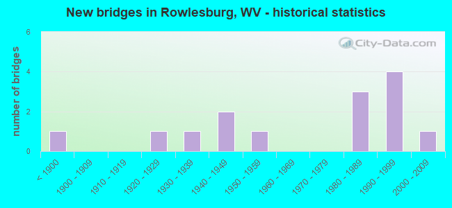
- New bridges - historical statistics
- 1Before 1900
- 11920-1929
- 11930-1939
- 21940-1949
- 11950-1959
- 31980-1989
- 41990-1999
- 12000-2009
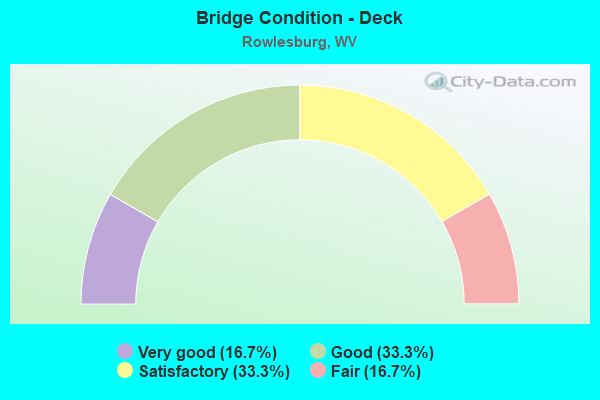
- Bridge Condition - Deck
- 16.7%Very good
- 33.3%Good
- 33.3%Satisfactory
- 16.7%Fair
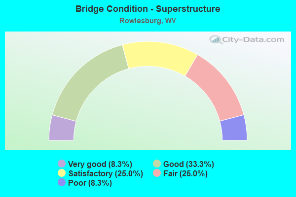
- Bridge Condition - Superstructure
- 8.3%Very good
- 33.3%Good
- 25.0%Satisfactory
- 25.0%Fair
- 8.3%Poor
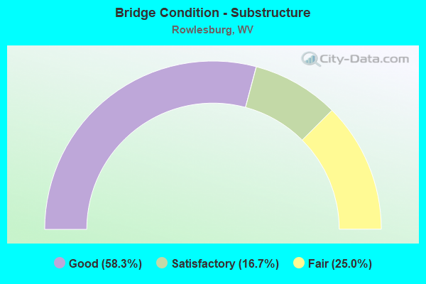
- Bridge Condition - Substructure
- 58.3%Good
- 16.7%Satisfactory
- 25.0%Fair
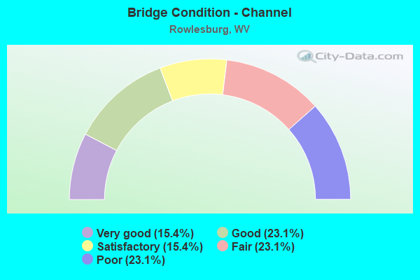
- Bridge Condition - Channel
- 15.4%Very good
- 23.1%Good
- 15.4%Satisfactory
- 23.1%Fair
- 23.1%Poor
Find on map >> Show street view
Structure Number: 39A109, Location: 0.02 MI EAST CO RT 50/13 (Lat: 39.319869, Lng: -79.656731), Route carried "on" structure: US 5000, Year Built: 1932, Year Reconstructed: 1987, Status: Posted for load, Structure Length: 14.02m (46.00ft), Average Daily Traffic: 900 (year 2019), Truck Traffic: 13%, Average Future Daily Traffic: 1,080 (year 2041), Design Load: HS 20, Features Intersected: CHEAT RIVER, Facility Carried by Structure: US ROUTE 50
Minimum Vertical Clearance: 4.29m (14.07ft), Kilometerpoint: 25.943, Lanes on structure: 2, Base Highway Network: Yes, Owner: State Highway Agency, Approaching Roadway Width: 7.6m (24.9ft), Skew: 3 degrees, Material/Design: Steel, Design/Construction: Truss - Thru, Number Of Spans In Main Unit: 3, Length of Maximum Span: 45.8m (150.3ft), Curb-To-Curb Width: 8.7m (28.5ft), Out-to-Out Width: 9.6m (31.5ft)
Condition: Deck: Satisfactory, Superstructure: Fair, Substructure: Fair, Channel: Fair, Operating Rating: 61.7 metric tons, Method Used To Determine Operating Rating: Load Factor (LF), Inventory Rating: 37.2 metric tons, Method Used To Determine Inventory Rating: Load Factor (LF), Structural Evaluation: Somewhat better than minimum adequacy, Deck Geometry: Meets minimum limits, Waterway Adequacy: Equal to present desirable criteria, Approach Roadway Alignment: Equal to present minimum criteria, Length Of Structure Improvement: 14.87m (48.79ft), Designated Inspection Frequency: Every 24 months, Critical Feature Inspection Frequency: Every 24 months, Underwater Inspection Frequency: Every 60 months, Inspection Date: October 2021, Critical Feature Inspection Date: October 2021, Underwater Inspection Date: July 2018, Bridge Improvement Cost: $1,933,000, Roadway Improvement Cost: $1,197,000, Total Project Cost: $3,884,000 ( Estimate for 2022), Deck Structure Type: Concrete Cast-file-Place, Wearing Surface/Protective System: Deck Protection: Epoxy Coated Reinforcing
Find on map >> Show street view
Structure Number: 39A116, Location: 0.13 MI NORTH WV RT 72 (Lat: 39.349500, Lng: -79.668100), Route carried "on" structure: County highway 5100, Year Built: 1987, Status: Open, Structure Length: 15.30m (50.20ft), Average Daily Traffic: 250 (year 2019), Truck Traffic: 7%, Average Future Daily Traffic: 350 (year 2041), Design Load: HS 25 or greater, Features Intersected: CHEAT RIVER, Facility Carried by Structure: PRESTON CO RT 51
Minimum Vertical Clearance: 30+ m (98+ ft), Kilometerpoint: 0.209, Lanes on structure: 2, Owner: State Highway Agency, Approaching Roadway Width: 8.5m (27.9ft), Material/Design: Steel continuous, Design/Construction: Stringer/Multi-beam, Number Of Spans In Main Unit: 3, Number Of Approach Spans: 2, Length of Maximum Span: 34.1m (111.9ft), Curb or Sidewalk Widths: Left: 0.0m, Right: 1.2m (3.9ft), Curb-To-Curb Width: 8.5m (27.9ft), Out-to-Out Width: 10.5m (34.4ft)
Condition: Deck: Fair, Superstructure: Good, Substructure: Fair, Channel: Good, Operating Rating: 88.0 metric tons, Method Used To Determine Operating Rating: Load Factor (LF), Inventory Rating: 52.6 metric tons, Method Used To Determine Inventory Rating: Load Factor (LF), Structural Evaluation: Somewhat better than minimum adequacy, Deck Geometry: Equal to present minimum criteria, Waterway Adequacy: Better than present minimum criteria, Approach Roadway Alignment: Better than present minimum criteria, Designated Inspection Frequency: Every 24 months, Underwater Inspection Frequency: Every 60 months, Inspection Date: September 2021, Underwater Inspection Date: July 2019, Deck Structure Type: Concrete Cast-file-Place, Wearing Surface/Protective System: Deck Protection: Epoxy Coated Reinforcing
Find on map >> Show street view
Structure Number: 39A118, Location: 0.03 MI EAST WV RT 72 (Lat: 39.319361, Lng: -79.687981), Route carried "on" structure: US 5000, Year Built: 1947, Status: Open, Structure Length: 4.50m (14.76ft), Average Daily Traffic: 1,200 (year 2018), Truck Traffic: 14%, Average Future Daily Traffic: 1,750 (year 2038), Design Load: HS 15, Features Intersected: BUFFALO CREEK, Facility Carried by Structure: US ROUTE 50
Minimum Vertical Clearance: 30+ m (98+ ft), Kilometerpoint: 22.772, Lanes on structure: 2, Base Highway Network: Yes, Owner: State Highway Agency, Approaching Roadway Width: 9.1m (29.9ft), Skew: 4 degrees, Material/Design: Concrete, Design/Construction: Tee Beam, Number Of Spans In Main Unit: 2, Number Of Approach Spans: 1, Length of Maximum Span: 14.4m (47.2ft), Curb or Sidewalk Widths: Left: 0.3m (1.0ft), Right: 0.3m (1.0ft), Curb-To-Curb Width: 8.5m (27.9ft), Out-to-Out Width: 9.8m (32.2ft)
Condition: Deck: Fair, Superstructure: Fair, Substructure: Fair, Channel: Good, Operating Rating: 32.7 metric tons, Method Used To Determine Operating Rating: Load and Resistance Factor (LRFR), Inventory Rating: 25.4 metric tons, Method Used To Determine Inventory Rating: Load and Resistance Factor (LRFR), Structural Evaluation: Somewhat better than minimum adequacy, Deck Geometry: Somewhat better than minimum adequacy, Waterway Adequacy: Equal to present minimum criteria, Approach Roadway Alignment: Better than present minimum criteria, Length Of Structure Improvement: 5.58m (18.31ft), Designated Inspection Frequency: Every 24 months, Inspection Date: May 2020, Bridge Improvement Cost: $517,000, Roadway Improvement Cost: $484,000, Total Project Cost: $1,174,000 ( Estimate for 2020), Deck Structure Type: Concrete Cast-file-Place, Wearing Surface/Protective System: Wearing Surface: Bituminous
Find on map >> Show street view
Structure Number: 39A121, Location: 1.21 MI WEST WV RT 72 (Lat: 39.320869, Lng: -79.714131), Route carried "on" structure: US 5000, Year Built: 1988, Status: Open, Structure Length: 1.97m (6.46ft), Average Daily Traffic: 1,200 (year 2018), Truck Traffic: 14%, Average Future Daily Traffic: 1,750 (year 2038), Design Load: HS 20, Features Intersected: FLAG RUN, Facility Carried by Structure: US ROUTE 50
Minimum Vertical Clearance: 30+ m (98+ ft), Kilometerpoint: 20.471, Lanes on structure: 2, Base Highway Network: Yes, Owner: State Highway Agency, Approaching Roadway Width: 11.6m (38.1ft), Skew: 4 degrees, Material/Design: Steel, Design/Construction: Stringer/Multi-beam, Number Of Spans In Main Unit: 1, Length of Maximum Span: 18.0m (59.1ft), Curb-To-Curb Width: 10.6m (34.8ft), Out-to-Out Width: 11.7m (38.4ft)
Condition: Deck: Good, Superstructure: Good, Substructure: Good, Channel: Satisfactory, Operating Rating: 88.9 metric tons, Method Used To Determine Operating Rating: Load Factor (LF), Inventory Rating: 59.0 metric tons, Method Used To Determine Inventory Rating: Load Factor (LF), Structural Evaluation: Better than present minimum criteria, Deck Geometry: Equal to present minimum criteria, Waterway Adequacy: Equal to present desirable criteria, Approach Roadway Alignment: Equal to present minimum criteria, Designated Inspection Frequency: Every 48 months, Inspection Date: April 2020, Deck Structure Type: Concrete Cast-file-Place, Wearing Surface/Protective System: Deck Protection: Epoxy Coated Reinforcing
Find on map >> Show street view
Structure Number: 39A125, Location: 0.01 MI NORTH CO RT 51 (Lat: 39.385681, Lng: -79.620231), Route carried "on" structure: County highway 5103, Year Built: 1981, Year Reconstructed: 1988, Status: Open, Structure Length: 1.16m (3.81ft), Average Daily Traffic: 10 (year 2019), Average Future Daily Traffic: 14 (year 2041), Design Load: HS 20, Features Intersected: SALTLICK CREEK, Facility Carried by Structure: PRESTON CO RT 51/3
Minimum Vertical Clearance: 30+ m (98+ ft), Kilometerpoint: 0.016, Lanes on structure: 1, Owner: State Highway Agency, Approaching Roadway Width: 3.0m (9.8ft), Material/Design: Steel, Design/Construction: Stringer/Multi-beam, Number Of Spans In Main Unit: 1, Length of Maximum Span: 10.0m (32.8ft), Curb-To-Curb Width: 4.2m (13.8ft), Out-to-Out Width: 4.3m (14.1ft)
Condition: Deck: Very good, Superstructure: Fair, Substructure: Good, Channel: Poor, Operating Rating: 48.1 metric tons, Method Used To Determine Operating Rating: Load Factor (LF), Inventory Rating: 28.1 metric tons, Method Used To Determine Inventory Rating: Load Factor (LF), Structural Evaluation: Somewhat better than minimum adequacy, Deck Geometry: Somewhat better than minimum adequacy, Waterway Adequacy: Equal to present minimum criteria, Approach Roadway Alignment: Equal to present minimum criteria, Length Of Structure Improvement: 1.77m (5.81ft), Designated Inspection Frequency: Every 24 months, Inspection Date: December 2020, Bridge Improvement Cost: $193,000, Roadway Improvement Cost: $161,000, Total Project Cost: $428,000 ( Estimate for 2021), Deck Structure Type: Wood or Timber
Find on map >> Show street view
Structure Number: 39A142, Location: 0.03 MI NORTH CO RT 72/6 (Lat: 39.316931, Lng: -79.693669), Route carried "on" structure: State highway 7200, Year Built: 1940, Status: Open, Structure Length: 1.32m (4.33ft), Average Daily Traffic: 700 (year 2018), Truck Traffic: 14%, Average Future Daily Traffic: 925 (year 2038), Design Load: HS 25 or greater, Features Intersected: FLAG RUN, Facility Carried by Structure: WV ROUTE 72
Minimum Vertical Clearance: 30+ m (98+ ft), Kilometerpoint: 9.640, Lanes on structure: 2, Owner: State Highway Agency, Approaching Roadway Width: 7.3m (24.0ft), Skew: 1 degrees, Material/Design: Concrete, Design/Construction: Tee Beam, Number Of Spans In Main Unit: 1, Length of Maximum Span: 12.2m (40.0ft), Curb-To-Curb Width: 7.1m (23.3ft), Out-to-Out Width: 8.2m (26.9ft)
Condition: Deck: Satisfactory, Superstructure: Satisfactory, Substructure: Satisfactory, Channel: Fair, Operating Rating: 88.9 metric tons, Method Used To Determine Operating Rating: Field evaluation and documented engineering judgment, Inventory Rating: 40.8 metric tons, Method Used To Determine Inventory Rating: Field evaluation and documented engineering judgment, Structural Evaluation: Equal to present minimum criteria, Deck Geometry: Meets minimum limits, Waterway Adequacy: Equal to present minimum criteria, Approach Roadway Alignment: Equal to present desirable criteria, Length Of Structure Improvement: 2.07m (6.79ft), Designated Inspection Frequency: Every 24 months, Inspection Date: May 2020, Bridge Improvement Cost: $262,000, Roadway Improvement Cost: $228,000, Total Project Cost: $593,000 ( Estimate for 2020), Deck Structure Type: Concrete Cast-file-Place, Wearing Surface/Protective System: Wearing Surface: Latex Concrete
Find on map >> Show street view
Structure Number: 39A149, Location: 0.01 MI EAST WV RT 72 (Lat: 39.288711, Lng: -79.704100), Route carried "on" structure: County highway 7203, Year Built: 1993, Status: Open, Structure Length: 1.69m (5.54ft), Average Daily Traffic: 50 (year 2019), Average Future Daily Traffic: 70 (year 2041), Design Load: HS 25 or greater, Features Intersected: BUFFALO CREEK, Facility Carried by Structure: PRESTON CO RT 72/3
Minimum Vertical Clearance: 30+ m (98+ ft), Kilometerpoint: 0.016, Lanes on structure: 2, Owner: State Highway Agency, Approaching Roadway Width: 4.9m (16.1ft), Skew: 2 degrees, Material/Design: Prestressed concrete, Design/Construction: Box Beam or Girders - Multiple, Number Of Spans In Main Unit: 1, Length of Maximum Span: 16.5m (54.1ft), Curb-To-Curb Width: 6.3m (20.7ft), Out-to-Out Width: 6.5m (21.3ft)
Condition: Deck: Satisfactory, Superstructure: Satisfactory, Substructure: Good, Channel: Very good, Operating Rating: 88.9 metric tons, Method Used To Determine Operating Rating: Load Factor (LF), Inventory Rating: 66.2 metric tons, Method Used To Determine Inventory Rating: Load Factor (LF), Structural Evaluation: Equal to present minimum criteria, Deck Geometry: Somewhat better than minimum adequacy, Waterway Adequacy: Better than present minimum criteria, Approach Roadway Alignment: Better than present minimum criteria, Designated Inspection Frequency: Every 48 months, Inspection Date: May 2021, Deck Structure Type: Other, Wearing Surface/Protective System: Deck Protection: Epoxy Coated Reinforcing
Find on map >> Show street view
Structure Number: 39A16, Location: 0.03 MI NORTH CO RT 51 (Lat: 39.386839, Lng: -79.629661), Route carried "on" structure: County highway 8600, Year Built: 1996, Status: Posted for load, Structure Length: 3.76m (12.34ft), Average Daily Traffic: 10 (year 2018), Average Future Daily Traffic: 13 (year 2041), Design Load: H 10, Features Intersected: SALTLICK CREEK, Facility Carried by Structure: PRESTON CO RT 86
Minimum Vertical Clearance: 8.33m (27.33ft), Kilometerpoint: 0.048, Lanes on structure: 1, Owner: State Highway Agency, Approaching Roadway Width: 3.0m (9.8ft), Skew: 9 degrees, Material/Design: Wood or Timber, Design/Construction: Stringer/Multi-beam, Number Of Spans In Main Unit: 1, Number Of Approach Spans: 2, Length of Maximum Span: 15.5m (50.9ft), Curb or Sidewalk Widths: Left: 0.1m (0.3ft), Right: 0.1m (0.3ft), Curb-To-Curb Width: 3.7m (12.1ft), Out-to-Out Width: 4.0m (13.1ft)
Condition: Deck: Satisfactory, Superstructure: Satisfactory, Substructure: Satisfactory, Channel: Satisfactory, Operating Rating: 20.9 metric tons, Method Used To Determine Operating Rating: Allowable Stress (AS), Inventory Rating: 13.6 metric tons, Method Used To Determine Inventory Rating: Allowable Stress (AS), Structural Evaluation: Meets minimum limits, Deck Geometry: Meets minimum limits, Waterway Adequacy: Better than present minimum criteria, Approach Roadway Alignment: Meets minimum limits, Bridge Posting: Required (Relationship of Operating Rating to Maximum Legal Load: > 39.9% below), Designated Inspection Frequency: Every 24 months, Critical Feature Inspection Frequency: Every 24 months, Inspection Date: December 2020, Critical Feature Inspection Date: December 2020, Deck Structure Type: Wood or Timber
Find on map >> Show street view
Structure Number: 39A18, Location: 0.70 MI EAST CO RT 51 (Lat: 39.384250, Lng: -79.600650), Route carried "on" structure: County highway 5109, Year Built: 1950, Year Reconstructed: 1992, Status: Posted for load, Structure Length: 1.07m (3.51ft), Average Daily Traffic: 10 (year 2018), Average Future Daily Traffic: 13 (year 2038), Features Intersected: WOLF RUN, Facility Carried by Structure: PRESTON CO RT 51/9
Minimum Vertical Clearance: 30+ m (98+ ft), Kilometerpoint: 1.127, Lanes on structure: 1, Owner: State Highway Agency, Approaching Roadway Width: 3.0m (9.8ft), Skew: 2 degrees, Material/Design: Steel, Design/Construction: Stringer/Multi-beam, Number Of Spans In Main Unit: 1, Length of Maximum Span: 10.3m (33.8ft), Curb-To-Curb Width: 3.4m (11.2ft), Out-to-Out Width: 3.8m (12.5ft)
Condition: Deck: Good, Superstructure: Poor, Substructure: Good, Channel: Poor, Operating Rating: 16.3 metric tons, Method Used To Determine Operating Rating: Load Factor (LF), Inventory Rating: 10.0 metric tons, Method Used To Determine Inventory Rating: Load Factor (LF), Structural Evaluation: High priority of replacement, Deck Geometry: High priority of corrective action, Waterway Adequacy: Meets minimum limits, Approach Roadway Alignment: Better than present minimum criteria, Bridge Posting: Required (Relationship of Operating Rating to Maximum Legal Load: > 39.9% below), Length Of Structure Improvement: 1.74m (5.71ft), Designated Inspection Frequency: Every 24 months, Inspection Date: June 2020, Bridge Improvement Cost: $147,000, Roadway Improvement Cost: $123,000, Total Project Cost: $334,000 ( Estimate for 2020), Deck Structure Type: Wood or Timber
Find on map >> Show street view
Structure Number: 39A185, Location: 1.37 MI EAST CO RT 50/9 (Lat: 39.324269, Lng: -79.722131), Route carried "on" structure: US 5000, Year Built: 1920, Status: Open, Structure Length: 0.69m (2.26ft), Average Daily Traffic: 1,200 (year 2019), Truck Traffic: 13%, Average Future Daily Traffic: 1,440 (year 2041), Features Intersected: FLAG RUN, Facility Carried by Structure: US ROUTE 50
Minimum Vertical Clearance: 30+ m (98+ ft), Kilometerpoint: 19.714, Lanes on structure: 2, Base Highway Network: Yes, Owner: State Highway Agency, Approaching Roadway Width: 8.5m (27.9ft), Material/Design: Concrete continuous, Design/Construction: Culvert, Number Of Spans In Main Unit: 2, Length of Maximum Span: 3.4m (11.2ft)
Condition: Channel: Fair, Culverts: Fair, Operating Rating: 63.5 metric tons, Method Used To Determine Operating Rating: Field evaluation and documented engineering judgment, Inventory Rating: 29.0 metric tons, Method Used To Determine Inventory Rating: Field evaluation and documented engineering judgment, Structural Evaluation: Somewhat better than minimum adequacy, Waterway Adequacy: Superior to present desirable criteria, Approach Roadway Alignment: Better than present minimum criteria, Length Of Structure Improvement: 1.28m (4.20ft), Designated Inspection Frequency: Every 24 months, Inspection Date: July 2021, Bridge Improvement Cost: $233,000, Roadway Improvement Cost: $161,000, Total Project Cost: $474,000 ( Estimate for 2021)
Find on map >> Show street view
Structure Number: 39A195, Location: 0.25 MI NORTH CO RT 51 (Lat: 39.389289, Lng: -79.630311), Route carried "on" structure: County highway 8600, Year Built: 1996, Status: Open, Structure Length: 1.16m (3.81ft), Average Daily Traffic: 10 (year 2017), Average Future Daily Traffic: 13 (year 2037), Design Load: HS 25 or greater, Features Intersected: SPRUCE RUN, Facility Carried by Structure: PRES CO RT 86
Minimum Vertical Clearance: 30+ m (98+ ft), Kilometerpoint: 0.402, Lanes on structure: 1, Owner: State Highway Agency, Approaching Roadway Width: 3.0m (9.8ft), Skew: 3 degrees, Material/Design: Steel, Design/Construction: Stringer/Multi-beam, Number Of Spans In Main Unit: 1, Length of Maximum Span: 10.1m (33.1ft), Curb or Sidewalk Widths: Left: 0.2m (0.7ft), Right: 0.2m (0.7ft), Curb-To-Curb Width: 4.1m (13.5ft), Out-to-Out Width: 4.3m (14.1ft)
Condition: Deck: Very good, Superstructure: Very good, Substructure: Good, Channel: Very good, Operating Rating: 69.8 metric tons, Method Used To Determine Operating Rating: Load Factor (LF), Inventory Rating: 41.7 metric tons, Method Used To Determine Inventory Rating: Load Factor (LF), Structural Evaluation: Better than present minimum criteria, Deck Geometry: Somewhat better than minimum adequacy, Waterway Adequacy: Better than present minimum criteria, Approach Roadway Alignment: Somewhat better than minimum adequacy, Designated Inspection Frequency: Every 48 months, Inspection Date: May 2019, Deck Structure Type: Wood or Timber
Find on map >> Show street view
Structure Number: 39A199, Location: 0.03 MI SOUTH CO RT 53/2 (Lat: 39.382350, Lng: -79.604681), Route carried "on" structure: County highway 5100, Year Built: 1997, Status: Open, Structure Length: 1.34m (4.40ft), Average Daily Traffic: 250 (year 2019), Truck Traffic: 7%, Average Future Daily Traffic: 350 (year 2041), Design Load: HS 25 or greater, Features Intersected: KINSINGER RUN, Facility Carried by Structure: PRESTON CO RT 51
Minimum Vertical Clearance: 30+ m (98+ ft), Kilometerpoint: 8.771, Lanes on structure: 2, Owner: State Highway Agency, Approaching Roadway Width: 6.1m (20.0ft), Skew: 3 degrees, Material/Design: Prestressed concrete, Design/Construction: Box Beam or Girders - Multiple, Number Of Spans In Main Unit: 1, Length of Maximum Span: 12.2m (40.0ft), Curb-To-Curb Width: 7.0m (23.0ft), Out-to-Out Width: 7.5m (24.6ft)
Condition: Deck: Good, Superstructure: Good, Substructure: Good, Channel: Poor, Operating Rating: 86.2 metric tons, Method Used To Determine Operating Rating: Load Factor (LF), Inventory Rating: 51.7 metric tons, Method Used To Determine Inventory Rating: Load Factor (LF), Structural Evaluation: Better than present minimum criteria, Deck Geometry: Meets minimum limits, Waterway Adequacy: Equal to present desirable criteria, Approach Roadway Alignment: Equal to present desirable criteria, Designated Inspection Frequency: Every 24 months, Inspection Date: August 2021, Deck Structure Type: Other, Wearing Surface/Protective System: Wearing Surface: Bituminous, Deck Protection: Epoxy Coated Reinforcing
Find on map >> Show street view
Structure Number: 39A224, Location: 0.01 MI NORTH CO RT 80/2 (Lat: 39.351650, Lng: -79.663161), Route carried "on" structure: County highway 5100, Year Built: 2004, Status: Open, Structure Length: 17.62m (57.81ft), Average Daily Traffic: 250 (year 2018), Truck Traffic: 13%, Average Future Daily Traffic: 325 (year 2038), Design Load: HL 93, Features Intersected: SALTLICK CREEK & CSX RR, Facility Carried by Structure: PRESTON CO RT 51
Minimum Vertical Clearance: 30+ m (98+ ft), Kilometerpoint: 1.191, Lanes on structure: 2, Owner: State Highway Agency, Approaching Roadway Width: 6.7m (22.0ft), Skew: 1 degrees, Material/Design: Prestressed concrete continuous, Design/Construction: Stringer/Multi-beam, Number Of Spans In Main Unit: 3, Number Of Approach Spans: 5, Length of Maximum Span: 30.5m (100.1ft), Curb-To-Curb Width: 8.5m (27.9ft), Out-to-Out Width: 9.3m (30.5ft)
Condition: Deck: Good, Superstructure: Good, Substructure: Good, Channel: Good, Operating Rating: 51.7 metric tons, Method Used To Determine Operating Rating: Load and Resistance Factor (LRFR), Inventory Rating: 39.9 metric tons, Method Used To Determine Inventory Rating: Load and Resistance Factor (LRFR), Structural Evaluation: Better than present minimum criteria, Deck Geometry: Equal to present minimum criteria, Underclear: Better than present minimum criteria, Waterway Adequacy: Superior to present desirable criteria, Approach Roadway Alignment: Meets minimum limits, Designated Inspection Frequency: Every 24 months, Inspection Date: October 2020, Deck Structure Type: Concrete Cast-file-Place, Wearing Surface/Protective System: Wearing Surface: Latex Concrete, Deck Protection: Epoxy Coated Reinforcing
Find on map >> Show street view
Structure Number: 39A205, Location: 0.04 MI NORTH CO RT 51 (Lat: 39.386750, Lng: -79.629561), Route carried "under" structure: County highway 8600, Year Built: 1865, Structure Length: 0. m, Average Daily Traffic: 10 (year 2018), Features Intersected: PRES CO 86 & SALTLICK CK, Facility Carried by Structure: CSX RAILROAD
Minimum Vertical Clearance: 8.33m (27.33ft), Kilometerpoint: 0.064, Lanes under structure: 1, Material/Design: Masonry, Design/Construction: Arch - Deck, Length of Maximum Span: 9.8m (32.2ft)