Bridge Statistics for Russell Springs, Kentucky (KY)
Condition, Traffic, Stress, Structural Evaluation, Project Costs
- National Bridge Inventory (NBI) Statistics
- 26Number of bridges
- 276ft / 84.1mTotal length
- $3,420,000Total costs
- 69,696Total average daily traffic
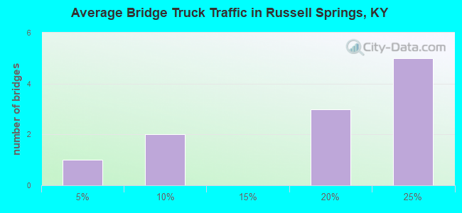
- 8,079Total average daily truck traffic
- National Bridge Inventory (NBI) Registered Bridges for Russell Springs
- No street view available for this location
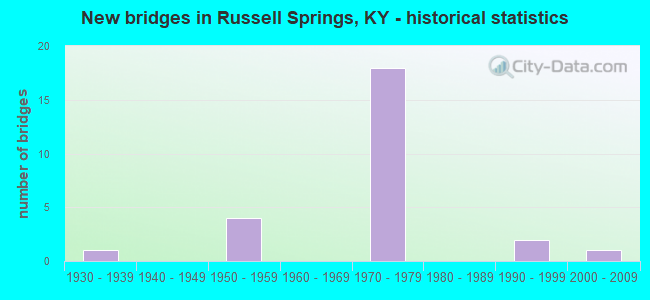
- New bridges - historical statistics
- 11930-1939
- 41950-1959
- 181970-1979
- 21990-1999
- 12000-2009

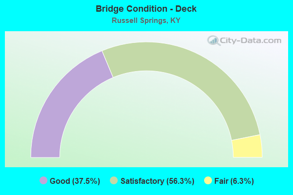
- Bridge Condition - Deck
- 37.5%Good
- 56.3%Satisfactory
- 6.3%Fair
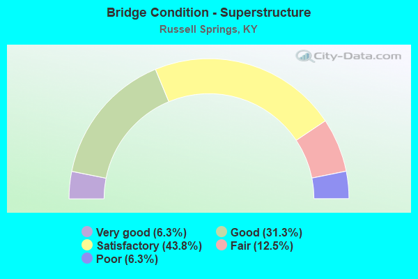
- Bridge Condition - Superstructure
- 6.3%Very good
- 31.3%Good
- 43.8%Satisfactory
- 12.5%Fair
- 6.3%Poor
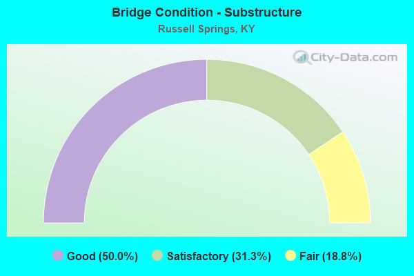
- Bridge Condition - Substructure
- 50.0%Good
- 31.3%Satisfactory
- 18.8%Fair
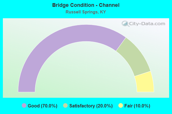
- Bridge Condition - Channel
- 70.0%Good
- 20.0%Satisfactory
- 10.0%Fair
Find on map >> Show street view
Structure Number: 1B00013N, Location: 1.5 MI WEST OF RUSSELL CL (Lat: 37.076111, Lng: -85.158333), Route carried "on" structure: State highway 80, Year Built: 1933, Status: Open, Structure Length: 3.57m (11.71ft), Average Daily Traffic: 2,590 (year 2020), Truck Traffic: 6%, Average Future Daily Traffic: 2,279 (year 2040), Design Load: H 20, Features Intersected: RUSSELL CREEK
Minimum Vertical Clearance: 30+ m (98+ ft), Kilometerpoint: 34.434, Lanes on structure: 2, Owner: State Highway Agency, Approaching Roadway Width: 6.1m (20.0ft), Material/Design: Concrete, Design/Construction: Tee Beam, Number Of Spans In Main Unit: 3, Length of Maximum Span: 11.0m (36.1ft), Curb or Sidewalk Widths: Left: 0.2m (0.7ft), Right: 0.2m (0.7ft), Curb-To-Curb Width: 7.0m (23.0ft), Out-to-Out Width: 7.9m (25.9ft)
Condition: Deck: Satisfactory, Superstructure: Poor, Substructure: Satisfactory, Channel: Good, Operating Rating: 62.4 metric tons, Method Used To Determine Operating Rating: Load Factor (LF), Inventory Rating: 37.5 metric tons, Method Used To Determine Inventory Rating: Load Factor (LF), Structural Evaluation: Meets minimum limits, Deck Geometry: High priority of replacement, Waterway Adequacy: Equal to present desirable criteria, Approach Roadway Alignment: Equal to present desirable criteria, Length Of Structure Improvement: 0.35m (1.15ft), Designated Inspection Frequency: Every 24 months, Inspection Date: July 2021, Bridge Improvement Cost: $370,000, Total Project Cost: $369,000, Deck Structure Type: Concrete Cast-file-Place, Wearing Surface/Protective System: Wearing Surface: Latex Concrete
Find on map >> Show street view
Structure Number: 1B00070N, Location: VIA CR'S 2.5 MI SE-KY 80 (Lat: 37.053611, Lng: -85.163889), Route carried "on" structure: County highway 1160, Year Built: 1972, Status: Open, Structure Length: 6.86m (22.51ft), Average Daily Traffic: 95 (year 2019), Average Future Daily Traffic: 82 (year 2039), Design Load: H 20, Features Intersected: CUMBERLAND PARKWAY, Facility Carried by Structure: PROVIDENCE CHURCH
Minimum Vertical Clearance: 30+ m (98+ ft), Kilometerpoint: 0.151, Lanes on structure: 2, Lanes under structure: 4, Owner: State Highway Agency, Approaching Roadway Width: 6.1m (20.0ft), Skew: 20 degrees, Material/Design: Concrete continuous, Design/Construction: Tee Beam, Number Of Spans In Main Unit: 4, Length of Maximum Span: 18.3m (60.0ft), Curb or Sidewalk Widths: Left: 0.2m (0.7ft), Right: 0.2m (0.7ft), Curb-To-Curb Width: 7.9m (25.9ft), Out-to-Out Width: 9.0m (29.5ft)
Condition: Deck: Satisfactory, Superstructure: Satisfactory, Substructure: Good, Operating Rating: 62.7 metric tons, Method Used To Determine Operating Rating: Load Factor (LF), Inventory Rating: 37.6 metric tons, Method Used To Determine Inventory Rating: Load Factor (LF), Structural Evaluation: Equal to present minimum criteria, Deck Geometry: Equal to present minimum criteria, Underclear: Equal to present minimum criteria, Approach Roadway Alignment: Equal to present desirable criteria, Designated Inspection Frequency: Every 24 months, Inspection Date: July 2021, Deck Structure Type: Concrete Cast-file-Place, Wearing Surface/Protective System: Wearing Surface: Monolithic Concrete
Find on map >> Show street view
Structure Number: 1C00046N, Location: 1.7 MI N JCT KY 80 (Lat: 37.083056, Lng: -85.155833), Route carried "on" structure: County highway 1167, Year Built: 1990, Status: Open, Structure Length: 1.46m (4.79ft), Average Daily Traffic: 86 (year 2019), Average Future Daily Traffic: 74 (year 2039), Design Load: HS 25 or greater, Features Intersected: RUSSELL CREEK, Facility Carried by Structure: GENTRY MILL RD
Minimum Vertical Clearance: 30+ m (98+ ft), Kilometerpoint: 2.430, Lanes on structure: 1, Owner: County Highway Agency, Approaching Roadway Width: 4.6m (15.1ft), Skew: 1 degrees, Material/Design: Prestressed concrete, Design/Construction: Box Beam or Girders - Multiple, Number Of Spans In Main Unit: 1, Length of Maximum Span: 13.7m (44.9ft), Curb-To-Curb Width: 4.6m (15.1ft), Out-to-Out Width: 4.9m (16.1ft)
Condition: Deck: Good, Superstructure: Good, Substructure: Good, Channel: Satisfactory, Operating Rating: 84.3 metric tons, Method Used To Determine Operating Rating: Load Factor (LF), Inventory Rating: 50.6 metric tons, Method Used To Determine Inventory Rating: Load Factor (LF), Structural Evaluation: Better than present minimum criteria, Deck Geometry: Better than present minimum criteria, Waterway Adequacy: Equal to present desirable criteria, Approach Roadway Alignment: High priority of corrective action, Length Of Structure Improvement: 0.15m (0.49ft), Designated Inspection Frequency: Every 24 months, Inspection Date: September 2021, Bridge Improvement Cost: $97,000, Total Project Cost: $97,000, Deck Structure Type: Concrete Precast Panels, Wearing Surface/Protective System: Wearing Surface: Bituminous
Find on map >> Show street view
Structure Number: 1C00047N, Location: .4 MI SE CR 5016 (Lat: 37.120833, Lng: -85.113333), Route carried "on" structure: County highway 1059, Year Built: 1991, Status: Posted for load, Structure Length: 0.67m (2.20ft), Average Daily Traffic: 253 (year 2019), Average Future Daily Traffic: 220 (year 2039), Design Load: HS 20, Features Intersected: SULPHUR CREEK, Facility Carried by Structure: ABRELL RD
Minimum Vertical Clearance: 30+ m (98+ ft), Kilometerpoint: 0.584, Lanes on structure: 1, Owner: County Highway Agency, Approaching Roadway Width: 3.8m (12.5ft), Material/Design: Concrete, Design/Construction: Box Beam or Girders - Multiple, Number Of Spans In Main Unit: 1, Length of Maximum Span: 6.2m (20.3ft), Curb or Sidewalk Widths: Left: 0.2m (0.7ft), Right: 0.2m (0.7ft), Curb-To-Curb Width: 4.0m (13.1ft), Out-to-Out Width: 4.3m (14.1ft)
Condition: Deck: Satisfactory, Superstructure: Fair, Substructure: Fair, Channel: Good, Operating Rating: 26.4 metric tons, Method Used To Determine Operating Rating: Load Factor (LF), Inventory Rating: 15.8 metric tons, Method Used To Determine Inventory Rating: Load Factor (LF), Structural Evaluation: Meets minimum limits, Deck Geometry: High priority of replacement, Waterway Adequacy: Equal to present minimum criteria, Approach Roadway Alignment: Equal to present minimum criteria, Bridge Posting: Required (Relationship of Operating Rating to Maximum Legal Load: > 39.9% below), Designated Inspection Frequency: Every 12 months, Inspection Date: September 2021, Deck Structure Type: Concrete Precast Panels, Wearing Surface/Protective System: Wearing Surface: Bituminous
Find on map >> Show street view
Structure Number: 104B00016N, Location: 1.1 MI N.W. OF JCT KY 80 (Lat: 37.095556, Lng: -85.029722), Route carried "on" structure: State highway 76, Year Built: 1955, Status: Open, Structure Length: 2.93m (9.61ft), Average Daily Traffic: 528 (year 2020), Average Future Daily Traffic: 464 (year 2040), Design Load: H 20, Features Intersected: LITTLE GOOSE CREEK - W.
Minimum Vertical Clearance: 30+ m (98+ ft), Kilometerpoint: 14.734, Lanes on structure: 2, Owner: State Highway Agency, Approaching Roadway Width: 6.4m (21.0ft), Skew: 1 degrees, Material/Design: Concrete, Design/Construction: Tee Beam, Number Of Spans In Main Unit: 2, Length of Maximum Span: 13.7m (44.9ft), Curb or Sidewalk Widths: Left: 0.3m (1.0ft), Right: 0.3m (1.0ft), Curb-To-Curb Width: 5.5m (18.0ft), Out-to-Out Width: 7.9m (25.9ft)
Condition: Deck: Good, Superstructure: Satisfactory, Substructure: Good, Channel: Good, Operating Rating: 70.7 metric tons, Method Used To Determine Operating Rating: Load Factor (LF), Inventory Rating: 42.4 metric tons, Method Used To Determine Inventory Rating: Load Factor (LF), Structural Evaluation: Equal to present minimum criteria, Deck Geometry: High priority of replacement, Waterway Adequacy: Superior to present desirable criteria, Approach Roadway Alignment: Equal to present desirable criteria, Length Of Structure Improvement: 0.29m (0.95ft), Designated Inspection Frequency: Every 24 months, Inspection Date: April 2021, Bridge Improvement Cost: $312,000, Total Project Cost: $312,000, Deck Structure Type: Concrete Cast-file-Place, Wearing Surface/Protective System: Wearing Surface: Latex Concrete
Find on map >> Show street view
Structure Number: 104B00017N, Location: 2.2 MI N.W. OF JCT KY 80 (Lat: 37.088889, Lng: -85.094167), Route carried "on" structure: State highway 1545, Year Built: 1955, Status: Open, Structure Length: 1.62m (5.31ft), Average Daily Traffic: 259 (year 2018), Average Future Daily Traffic: 225 (year 2038), Design Load: H 15, Features Intersected: HUDSON CREEK
Minimum Vertical Clearance: 30+ m (98+ ft), Kilometerpoint: 3.695, Lanes on structure: 2, Owner: State Highway Agency, Approaching Roadway Width: 5.2m (17.1ft), Skew: 3 degrees, Material/Design: Concrete, Design/Construction: Culvert, Number Of Spans In Main Unit: 3, Length of Maximum Span: 4.3m (14.1ft)
Condition: Channel: Good, Culverts: Satisfactory, Operating Rating: 99.8 metric tons, Method Used To Determine Operating Rating: Load Testing, Inventory Rating: 72.6 metric tons, Method Used To Determine Inventory Rating: Load Testing, Structural Evaluation: Equal to present minimum criteria, Waterway Adequacy: Better than present minimum criteria, Approach Roadway Alignment: Equal to present desirable criteria, Designated Inspection Frequency: Every 24 months, Inspection Date: April 2021
Find on map >> Show street view
Structure Number: 104B00018N, Location: .1 MI E OF JCT KY 1729 (Lat: 37.090278, Lng: -85.103611), Route carried "on" structure: State highway 2283, Year Built: 1955, Status: Open, Structure Length: 1.40m (4.59ft), Average Daily Traffic: 492 (year 2018), Average Future Daily Traffic: 428 (year 2038), Design Load: H 15, Features Intersected: WILLIAMS CREEK
Minimum Vertical Clearance: 30+ m (98+ ft), Kilometerpoint: 0.224, Lanes on structure: 2, Owner: State Highway Agency, Approaching Roadway Width: 6.1m (20.0ft), Skew: 3 degrees, Material/Design: Concrete, Design/Construction: Culvert, Number Of Spans In Main Unit: 3, Length of Maximum Span: 3.7m (12.1ft)
Condition: Channel: Good, Culverts: Satisfactory, Operating Rating: 99.8 metric tons, Method Used To Determine Operating Rating: Load Testing, Inventory Rating: 63.3 metric tons, Method Used To Determine Inventory Rating: Load Testing, Structural Evaluation: Equal to present minimum criteria, Waterway Adequacy: Meets minimum limits, Approach Roadway Alignment: Equal to present desirable criteria, Designated Inspection Frequency: Every 24 months, Inspection Date: April 2021
Find on map >> Show street view
Structure Number: 104B00019N, Location: .1 MI N OF JCT KY 2283 (Lat: 37.092778, Lng: -85.106389), Route carried "on" structure: State highway 1729, Year Built: 1959, Status: Open, Structure Length: 2.62m (8.60ft), Average Daily Traffic: 912 (year 2020), Average Future Daily Traffic: 802 (year 2040), Design Load: H 20, Features Intersected: RUSSELL CREEK
Minimum Vertical Clearance: 30+ m (98+ ft), Kilometerpoint: 2.079, Lanes on structure: 2, Owner: State Highway Agency, Approaching Roadway Width: 6.7m (22.0ft), Material/Design: Concrete, Design/Construction: Tee Beam, Number Of Spans In Main Unit: 2, Length of Maximum Span: 12.2m (40.0ft), Curb or Sidewalk Widths: Left: 0.4m (1.3ft), Right: 0.4m (1.3ft), Curb-To-Curb Width: 7.9m (25.9ft), Out-to-Out Width: 9.2m (30.2ft)
Condition: Deck: Good, Superstructure: Satisfactory, Substructure: Good, Channel: Fair, Operating Rating: 73.9 metric tons, Method Used To Determine Operating Rating: Load Factor (LF), Inventory Rating: 44.4 metric tons, Method Used To Determine Inventory Rating: Load Factor (LF), Structural Evaluation: Equal to present minimum criteria, Deck Geometry: Somewhat better than minimum adequacy, Waterway Adequacy: Somewhat better than minimum adequacy, Approach Roadway Alignment: Equal to present minimum criteria, Designated Inspection Frequency: Every 24 months, Inspection Date: April 2021, Deck Structure Type: Concrete Cast-file-Place, Wearing Surface/Protective System: Wearing Surface: Latex Concrete
Find on map >> Show street view
Structure Number: 104B00020N, Location: .8 MI NW OF JCT US 127 (Lat: 37.048333, Lng: -85.083889), Route carried "on" structure: State highway 430, Year Built: 1973, Status: Open, Structure Length: 7.02m (23.03ft), Average Daily Traffic: 4,186 (year 2020), Average Future Daily Traffic: 3,683 (year 2040), Design Load: H 20, Features Intersected: CUMBERLAND PARKWAY
Minimum Vertical Clearance: 30+ m (98+ ft), Kilometerpoint: 1.384, Lanes on structure: 2, Lanes under structure: 4, Owner: State Highway Agency, Approaching Roadway Width: 7.3m (24.0ft), Skew: 20 degrees, Material/Design: Concrete continuous, Design/Construction: Tee Beam, Number Of Spans In Main Unit: 4, Length of Maximum Span: 18.3m (60.0ft), Curb or Sidewalk Widths: Left: 0.2m (0.7ft), Right: 0.2m (0.7ft), Curb-To-Curb Width: 9.1m (29.9ft), Out-to-Out Width: 10.2m (33.5ft)
Condition: Deck: Satisfactory, Superstructure: Good, Substructure: Good, Operating Rating: 72.0 metric tons, Method Used To Determine Operating Rating: Load Factor (LF), Inventory Rating: 43.3 metric tons, Method Used To Determine Inventory Rating: Load Factor (LF), Structural Evaluation: Better than present minimum criteria, Deck Geometry: Meets minimum limits, Underclear: Equal to present minimum criteria, Approach Roadway Alignment: Equal to present desirable criteria, Designated Inspection Frequency: Every 24 months, Inspection Date: April 2021, Deck Structure Type: Concrete Cast-file-Place, Wearing Surface/Protective System: Wearing Surface: Monolithic Concrete
Find on map >> Show street view
Structure Number: 104B00021N, Location: 1 MI SW OF JCT KY 430 (Lat: 37.044722, Lng: -85.099722), Route carried "on" structure: State highway 379, Year Built: 1973, Status: Open, Structure Length: 10.60m (34.78ft), Average Daily Traffic: 2,939 (year 2020), Truck Traffic: 5%, Average Future Daily Traffic: 2,586 (year 2040), Design Load: HS 20+Mod, Features Intersected: CUMBERLAND PARKWAY
Minimum Vertical Clearance: 30+ m (98+ ft), Kilometerpoint: 29.577, Lanes on structure: 2, Lanes under structure: 4, Owner: State Highway Agency, Approaching Roadway Width: 7.3m (24.0ft), Skew: 24 degrees, Material/Design: Concrete continuous, Design/Construction: Tee Beam, Number Of Spans In Main Unit: 4, Length of Maximum Span: 27.4m (89.9ft), Curb or Sidewalk Widths: Left: 0.2m (0.7ft), Right: 0.2m (0.7ft), Curb-To-Curb Width: 9.1m (29.9ft), Out-to-Out Width: 10.2m (33.5ft)
Condition: Deck: Satisfactory, Superstructure: Satisfactory, Substructure: Satisfactory, Operating Rating: 79.7 metric tons, Method Used To Determine Operating Rating: Load Factor (LF), Inventory Rating: 47.8 metric tons, Method Used To Determine Inventory Rating: Load Factor (LF), Structural Evaluation: Equal to present minimum criteria, Deck Geometry: Meets minimum limits, Underclear: Equal to present minimum criteria, Approach Roadway Alignment: Equal to present desirable criteria, Designated Inspection Frequency: Every 24 months, Inspection Date: April 2021, Deck Structure Type: Concrete Cast-file-Place, Wearing Surface/Protective System: Wearing Surface: Latex Concrete
Find on map >> Show street view
Structure Number: 104B00022N, Location: OVR CMBLND PW NTRCH + TP (Lat: 37.051389, Lng: -85.070000), Route carried "on" structure: US 127, Year Built: 1973, Status: Open, Structure Length: 8.20m (26.90ft), Average Daily Traffic: 13,218 (year 2020), Truck Traffic: 4%, Average Future Daily Traffic: 12,424 (year 2040), Design Load: HS 20+Mod, Features Intersected: CUMBERLAND PARKWAY
Minimum Vertical Clearance: 30+ m (98+ ft), Kilometerpoint: 28.392, Lanes on structure: 2, Lanes under structure: 4, Base Highway Network: Yes, Owner: State Highway Agency, Approaching Roadway Width: 15.2m (49.9ft), Skew: 21 degrees, Material/Design: Steel continuous, Design/Construction: Stringer/Multi-beam, Number Of Spans In Main Unit: 4, Length of Maximum Span: 24.4m (80.1ft), Curb or Sidewalk Widths: Left: 0.2m (0.7ft), Right: 0.2m (0.7ft), Curb-To-Curb Width: 14.6m (47.9ft), Out-to-Out Width: 20.0m (65.6ft)
Condition: Deck: Good, Superstructure: Satisfactory, Substructure: Satisfactory, Operating Rating: 64.0 metric tons, Method Used To Determine Operating Rating: Load Factor (LF), Inventory Rating: 38.4 metric tons, Method Used To Determine Inventory Rating: Load Factor (LF), Structural Evaluation: Equal to present minimum criteria, Deck Geometry: Superior to present desirable criteria, Underclear: Better than present minimum criteria, Approach Roadway Alignment: Equal to present desirable criteria, Length Of Structure Improvement: 0.82m (2.69ft), Designated Inspection Frequency: Every 24 months, Inspection Date: April 2021, Bridge Improvement Cost: $2,643,000, Total Project Cost: $2,642,000, Deck Structure Type: Concrete Cast-file-Place, Wearing Surface/Protective System: Wearing Surface: Latex Concrete
Find on map >> Show street view
Structure Number: 104B00023N, Location: .2 MI S OF JCT KY 80 (Lat: 37.070556, Lng: -85.026111), Route carried "on" structure: State highway 910, Year Built: 1973, Status: Open, Structure Length: 6.86m (22.51ft), Average Daily Traffic: 3,403 (year 2019), Average Future Daily Traffic: 2,994 (year 2039), Design Load: H 20, Features Intersected: CUMBERLAND PARKWAY
Minimum Vertical Clearance: 30+ m (98+ ft), Kilometerpoint: 0.447, Lanes on structure: 2, Lanes under structure: 4, Owner: State Highway Agency, Approaching Roadway Width: 7.3m (24.0ft), Skew: 20 degrees, Material/Design: Concrete continuous, Design/Construction: Tee Beam, Number Of Spans In Main Unit: 4, Length of Maximum Span: 18.3m (60.0ft), Curb or Sidewalk Widths: Left: 0.2m (0.7ft), Right: 0.2m (0.7ft), Curb-To-Curb Width: 9.1m (29.9ft), Out-to-Out Width: 10.2m (33.5ft)
Condition: Deck: Good, Superstructure: Good, Substructure: Satisfactory, Operating Rating: 72.1 metric tons, Method Used To Determine Operating Rating: Load Factor (LF), Inventory Rating: 43.3 metric tons, Method Used To Determine Inventory Rating: Load Factor (LF), Structural Evaluation: Equal to present minimum criteria, Deck Geometry: Meets minimum limits, Underclear: Equal to present minimum criteria, Approach Roadway Alignment: Equal to present desirable criteria, Designated Inspection Frequency: Every 24 months, Inspection Date: April 2021, Deck Structure Type: Concrete Cast-file-Place, Wearing Surface/Protective System: Wearing Surface: Latex Concrete
Find on map >> Show street view
Structure Number: 104B00025N, Location: .3 MI E OF N-JCT US 127 (Lat: 37.054444, Lng: -85.063056), Route carried "on" structure: State highway 619, Year Built: 1973, Status: Open, Structure Length: 7.92m (25.98ft), Average Daily Traffic: 4,189 (year 2020), Average Future Daily Traffic: 3,686 (year 2040), Design Load: HS 20+Mod, Features Intersected: CUMBERLAND PARKWAY
Minimum Vertical Clearance: 30+ m (98+ ft), Kilometerpoint: 25.445, Lanes on structure: 2, Lanes under structure: 4, Owner: State Highway Agency, Approaching Roadway Width: 7.3m (24.0ft), Skew: 22 degrees, Material/Design: Concrete continuous, Design/Construction: Tee Beam, Number Of Spans In Main Unit: 4, Length of Maximum Span: 20.1m (65.9ft), Curb or Sidewalk Widths: Left: 0.2m (0.7ft), Right: 0.2m (0.7ft), Curb-To-Curb Width: 9.1m (29.9ft), Out-to-Out Width: 10.2m (33.5ft)
Condition: Deck: Satisfactory, Superstructure: Satisfactory, Substructure: Satisfactory, Operating Rating: 82.6 metric tons, Method Used To Determine Operating Rating: Load Factor (LF), Inventory Rating: 49.6 metric tons, Method Used To Determine Inventory Rating: Load Factor (LF), Structural Evaluation: Equal to present minimum criteria, Deck Geometry: Meets minimum limits, Underclear: Equal to present minimum criteria, Approach Roadway Alignment: Equal to present desirable criteria, Designated Inspection Frequency: Every 24 months, Inspection Date: April 2021, Deck Structure Type: Concrete Cast-file-Place, Wearing Surface/Protective System: Wearing Surface: Monolithic Concrete
Find on map >> Show street view
Structure Number: 104B00027N, Location: .25 MI S OF JCT KY 1870 (Lat: 37.047778, Lng: -85.145833), Route carried "on" structure: County highway 1403, Year Built: 1972, Status: Open, Structure Length: 8.11m (26.61ft), Average Daily Traffic: 50 (year 2009), Average Future Daily Traffic: 61 (year 2029), Design Load: H 20, Features Intersected: CUMBERLAND PARKWAY, Facility Carried by Structure: NORTH GRIDER RD
Minimum Vertical Clearance: 30+ m (98+ ft), Kilometerpoint: 0.455, Lanes on structure: 2, Lanes under structure: 4, Owner: State Highway Agency, Approaching Roadway Width: 5.2m (17.1ft), Skew: 23 degrees, Material/Design: Concrete continuous, Design/Construction: Tee Beam, Number Of Spans In Main Unit: 4, Length of Maximum Span: 21.3m (69.9ft), Curb or Sidewalk Widths: Left: 0.2m (0.7ft), Right: 0.2m (0.7ft), Curb-To-Curb Width: 7.9m (25.9ft), Out-to-Out Width: 9.0m (29.5ft)
Condition: Deck: Satisfactory, Superstructure: Good, Substructure: Good, Operating Rating: 55.2 metric tons, Method Used To Determine Operating Rating: Load Factor (LF), Inventory Rating: 33.1 metric tons, Method Used To Determine Inventory Rating: Load Factor (LF), Structural Evaluation: Better than present minimum criteria, Deck Geometry: Equal to present minimum criteria, Underclear: Equal to present minimum criteria, Approach Roadway Alignment: Equal to present desirable criteria, Designated Inspection Frequency: Every 24 months, Inspection Date: April 2021, Deck Structure Type: Concrete Cast-file-Place, Wearing Surface/Protective System: Wearing Surface: Monolithic Concrete
Find on map >> Show street view
Structure Number: 104B00028N, Location: .3 MI S OF JCT KY 1870 (Lat: 37.045833, Lng: -85.128611), Route carried "on" structure: County highway 1402, Year Built: 1972, Status: Open, Structure Length: 7.17m (23.52ft), Average Daily Traffic: 30 (year 2019), Average Future Daily Traffic: 26 (year 2039), Design Load: H 20, Features Intersected: CUMBERLAND PARKWAY, Facility Carried by Structure: MILLER CEMETERY RD
Minimum Vertical Clearance: 30+ m (98+ ft), Kilometerpoint: 0.533, Lanes on structure: 2, Lanes under structure: 4, Owner: State Highway Agency, Approaching Roadway Width: 4.9m (16.1ft), Skew: 20 degrees, Material/Design: Concrete continuous, Design/Construction: Tee Beam, Number Of Spans In Main Unit: 4, Length of Maximum Span: 18.3m (60.0ft), Curb or Sidewalk Widths: Left: 0.2m (0.7ft), Right: 0.2m (0.7ft), Curb-To-Curb Width: 7.9m (25.9ft), Out-to-Out Width: 9.0m (29.5ft)
Condition: Deck: Satisfactory, Superstructure: Good, Substructure: Good, Operating Rating: 48.4 metric tons, Method Used To Determine Operating Rating: Load Factor (LF), Inventory Rating: 29.0 metric tons, Method Used To Determine Inventory Rating: Load Factor (LF), Structural Evaluation: Better than present minimum criteria, Deck Geometry: Equal to present minimum criteria, Underclear: Equal to present minimum criteria, Approach Roadway Alignment: Equal to present desirable criteria, Designated Inspection Frequency: Every 24 months, Inspection Date: April 2021, Deck Structure Type: Concrete Cast-file-Place, Wearing Surface/Protective System: Wearing Surface: Monolithic Concrete
Find on map >> Show street view
Structure Number: 104B00036N, Location: 0.414 MI. E. JCT KY 379 (Lat: 37.032222, Lng: -85.093333), Route carried "on" structure: State highway 3280, Year Built: 2009, Status: Open, Structure Length: 4.13m (13.55ft), Average Daily Traffic: 1,496 (year 2020), Average Future Daily Traffic: 1,316 (year 2040), Design Load: HS 25 or greater, Features Intersected: GREASY CREEK
Minimum Vertical Clearance: 30+ m (98+ ft), Kilometerpoint: 6.901, Lanes on structure: 2, Owner: State Highway Agency, Approaching Roadway Width: 7.3m (24.0ft), Skew: 4 degrees, Material/Design: Prestressed concrete, Design/Construction: Stringer/Multi-beam, Number Of Spans In Main Unit: 1, Length of Maximum Span: 40.2m (131.9ft), Curb or Sidewalk Widths: Left: 0.5m (1.6ft), Right: 0.5m (1.6ft), Curb-To-Curb Width: 12.2m (40.0ft), Out-to-Out Width: 13.1m (43.0ft)
Condition: Deck: Good, Superstructure: Very good, Substructure: Good, Channel: Good, Operating Rating: 99.8 metric tons, Method Used To Determine Operating Rating: Load Factor (LF), Inventory Rating: 79.1 metric tons, Method Used To Determine Inventory Rating: Load Factor (LF), Structural Evaluation: Better than present minimum criteria, Deck Geometry: Better than present minimum criteria, Waterway Adequacy: Equal to present desirable criteria, Approach Roadway Alignment: Equal to present desirable criteria, Designated Inspection Frequency: Every 24 months, Inspection Date: April 2021, Deck Structure Type: Concrete Cast-file-Place, Wearing Surface/Protective System: Wearing Surface: Monolithic Concrete, Deck Protection: Epoxy Coated Reinforcing
Find on map >> Show street view
Structure Number: 104C00008N, Location: 1.0 MILE NW OF KY 92 (Lat: 37.018611, Lng: -85.145833), Route carried "on" structure: County highway 1420, Year Built: 1974, Status: Posted for load, Structure Length: 0.94m (3.08ft), Average Daily Traffic: 119 (year 2019), Average Future Daily Traffic: 103 (year 2039), Features Intersected: REYNOLDS CREEK, Facility Carried by Structure: MOUNT PLEASANT RD
Minimum Vertical Clearance: 30+ m (98+ ft), Kilometerpoint: 1.568, Lanes on structure: 2, Owner: County Highway Agency, Approaching Roadway Width: 4.9m (16.1ft), Skew: 3 degrees, Material/Design: Steel, Design/Construction: Stringer/Multi-beam, Number Of Spans In Main Unit: 1, Length of Maximum Span: 8.2m (26.9ft), Curb-To-Curb Width: 5.3m (17.4ft), Out-to-Out Width: 5.5m (18.0ft)
Condition: Deck: Fair, Superstructure: Fair, Substructure: Fair, Channel: Satisfactory, Operating Rating: 24.3 metric tons, Method Used To Determine Operating Rating: Load Factor (LF), Inventory Rating: 14.6 metric tons, Method Used To Determine Inventory Rating: Load Factor (LF), Structural Evaluation: Meets minimum limits, Deck Geometry: High priority of replacement, Waterway Adequacy: Better than present minimum criteria, Approach Roadway Alignment: Equal to present minimum criteria, Bridge Posting: Required (Relationship of Operating Rating to Maximum Legal Load: > 39.9% below), Designated Inspection Frequency: Every 12 months, Inspection Date: December 2021, Deck Structure Type: Concrete Precast Panels, Wearing Surface/Protective System: Wearing Surface: Bituminous
Find on map >> Show street view
Structure Number: 104C00009N, Location: 1.0 MI. W.-JCT. US 127 (Lat: 37.018611, Lng: -85.090000), Route carried "on" structure: County highway 1431, Year Built: 1971, Status: Posted for load, Structure Length: 2.01m (6.59ft), Average Daily Traffic: 306 (year 2019), Average Future Daily Traffic: 266 (year 2039), Features Intersected: PERKINS CREEK, Facility Carried by Structure: AIRPORT RD
Minimum Vertical Clearance: 30+ m (98+ ft), Kilometerpoint: 1.099, Lanes on structure: 2, Owner: County Highway Agency, Approaching Roadway Width: 4.9m (16.1ft), Material/Design: Concrete, Design/Construction: Slab, Number Of Spans In Main Unit: 2, Length of Maximum Span: 3.7m (12.1ft), Curb-To-Curb Width: 5.5m (18.0ft), Out-to-Out Width: 5.5m (18.0ft)
Condition: Deck: Satisfactory, Superstructure: Satisfactory, Substructure: Fair, Channel: Good, Operating Rating: 16.3 metric tons, Method Used To Determine Operating Rating: Field evaluation and documented engineering judgment, Inventory Rating: 16.3 metric tons, Method Used To Determine Inventory Rating: Field evaluation and documented engineering judgment, Structural Evaluation: Somewhat better than minimum adequacy, Deck Geometry: High priority of corrective action, Waterway Adequacy: Equal to present minimum criteria, Approach Roadway Alignment: Equal to present minimum criteria, Bridge Posting: Required (Relationship of Operating Rating to Maximum Legal Load: > 39.9% below), Designated Inspection Frequency: Every 24 months, Inspection Date: December 2020, Deck Structure Type: Concrete Cast-file-Place, Wearing Surface/Protective System: Wearing Surface: Bituminous
Find on map >> Show street view
Structure Number: 1B00070N, Location: VIA CR'S 2.5 MI SE-KY 80 (Lat: 37.053611, Lng: -85.163889), Route carried "under" structure: State highway 9008, Year Built: 1972, Structure Length: 0. m, Average Daily Traffic: 6,909 (year 2020), Truck Traffic: 21%, Features Intersected: CUMBERLAND PARKWAY, Facility Carried by Structure: PROVIDENCE CHURCH
Minimum Vertical Clearance: 5.56m (18.24ft), Kilometerpoint: 91.926, Lanes on structure: 2, Lanes under structure: 4, Material/Design: Concrete continuous, Design/Construction: Tee Beam, Length of Maximum Span: 18.3m (60.0ft)
Find on map >> Show street view
Structure Number: 104B00020N, Location: .8 MI NW OF JCT US 127 (Lat: 37.048333, Lng: -85.083889), Route carried "under" structure: State highway 9008, Year Built: 1973, Structure Length: 0. m, Average Daily Traffic: 6,909 (year 2020), Truck Traffic: 21%, Features Intersected: CUMBERLAND PARKWAY, Facility Carried by Structure: KY-430
Minimum Vertical Clearance: 5.56m (18.24ft), Kilometerpoint: 99.260, Lanes on structure: 2, Lanes under structure: 4, Material/Design: Concrete continuous, Design/Construction: Tee Beam, Length of Maximum Span: 18.3m (60.0ft)
Find on map >> Show street view
Structure Number: 104B00021N, Location: 1 MI SW OF JCT KY 430 (Lat: 37.044722, Lng: -85.099722), Route carried "under" structure: State highway 9008, Year Built: 1973, Structure Length: 0. m, Average Daily Traffic: 6,909 (year 2020), Truck Traffic: 21%, Features Intersected: CUMBERLAND PARKWAY, Facility Carried by Structure: KY-379
Minimum Vertical Clearance: 5.97m (19.59ft), Kilometerpoint: 97.772, Lanes on structure: 2, Lanes under structure: 4, Material/Design: Concrete continuous, Design/Construction: Tee Beam, Length of Maximum Span: 27.4m (89.9ft)
Find on map >> Show street view
Structure Number: 104B00022N, Location: OVR CMBLND PW NTRCH + TP (Lat: 37.051389, Lng: -85.070000), Route carried "under" structure: State highway 9008, Year Built: 1973, Structure Length: 0. m, Truck Traffic: 17%, Features Intersected: CUMBERLAND PARKWAY, Facility Carried by Structure: US-127
Minimum Vertical Clearance: 5.31m (17.42ft), Kilometerpoint: 100.513, Lanes on structure: 2, Lanes under structure: 4, Material/Design: Steel continuous, Design/Construction: Stringer/Multi-beam, Length of Maximum Span: 24.4m (80.1ft)
Find on map >> Show street view
Structure Number: 104B00023N, Location: .2 MI S OF JCT KY 80 (Lat: 37.070556, Lng: -85.026111), Route carried "under" structure: State highway 9008, Year Built: 1973, Structure Length: 0. m, Truck Traffic: 17%, Features Intersected: CUMBERLAND PARKWAY, Facility Carried by Structure: KY-910
Minimum Vertical Clearance: 5.36m (17.59ft), Kilometerpoint: 105.076, Lanes on structure: 2, Lanes under structure: 4, Material/Design: Concrete continuous, Design/Construction: Tee Beam, Length of Maximum Span: 18.3m (60.0ft)
Find on map >> Show street view
Structure Number: 104B00025N, Location: .3 MI E OF N-JCT US 127 (Lat: 37.054444, Lng: -85.063056), Route carried "under" structure: State highway 9008, Year Built: 1973, Structure Length: 0. m, Truck Traffic: 17%, Features Intersected: CUMBERLAND PARKWAY, Facility Carried by Structure: KY-619
Minimum Vertical Clearance: 5.92m (19.42ft), Kilometerpoint: 101.215, Lanes on structure: 2, Lanes under structure: 4, Material/Design: Concrete continuous, Design/Construction: Tee Beam, Length of Maximum Span: 20.1m (65.9ft)
Find on map >> Show street view
Structure Number: 104B00027N, Location: .25 MI S OF JCT KY 1870 (Lat: 37.047778, Lng: -85.145833), Route carried "under" structure: State highway 9008, Year Built: 1972, Structure Length: 0. m, Average Daily Traffic: 6,909 (year 2020), Truck Traffic: 21%, Features Intersected: CUMBERLAND PARKWAY, Facility Carried by Structure: NORTH GRIDER RD
Minimum Vertical Clearance: 5.51m (18.08ft), Kilometerpoint: 93.661, Lanes on structure: 2, Lanes under structure: 4, Material/Design: Concrete continuous, Design/Construction: Tee Beam, Length of Maximum Span: 21.3m (69.9ft)
Find on map >> Show street view
Structure Number: 104B00028N, Location: .3 MI S OF JCT KY 1870 (Lat: 37.045833, Lng: -85.128611), Route carried "under" structure: State highway 9008, Year Built: 1972, Structure Length: 0. m, Average Daily Traffic: 6,909 (year 2020), Truck Traffic: 21%, Features Intersected: CUMBERLAND PARKWAY, Facility Carried by Structure: MILLER CEMETERY RD
Minimum Vertical Clearance: 5.97m (19.59ft), Kilometerpoint: 95.228, Lanes on structure: 2, Lanes under structure: 4, Material/Design: Concrete continuous, Design/Construction: Tee Beam, Length of Maximum Span: 18.3m (60.0ft)