Bridge Statistics for Saco, Maine (ME)
Condition, Traffic, Stress, Structural Evaluation, Project Costs
- National Bridge Inventory (NBI) Statistics
- 24Number of bridges
- 335ft / 102mTotal length
- 356,246Total average daily traffic
- 30,785Total average daily truck traffic
- National Bridge Inventory (NBI) Registered Bridges for Saco
- No street view available for this location
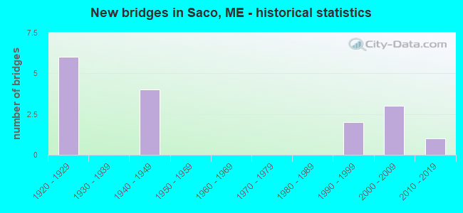
- New bridges - historical statistics
- 61920-1929
- 41940-1949
- 21990-1999
- 32000-2009
- 12010-2019
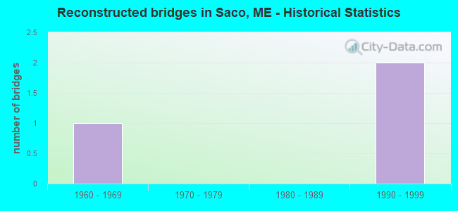
- Reconstructed bridges - Historical Statistics
- 11960-1969
- 01970-1979
- 01980-1989
- 21990-1999
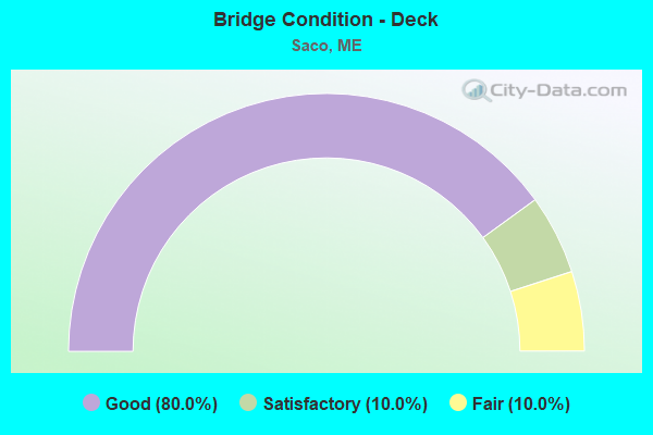
- Bridge Condition - Deck
- 80.0%Good
- 10.0%Satisfactory
- 10.0%Fair
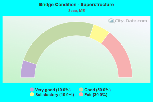
- Bridge Condition - Superstructure
- 10.0%Very good
- 50.0%Good
- 10.0%Satisfactory
- 30.0%Fair
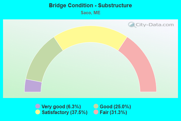
- Bridge Condition - Substructure
- 6.3%Very good
- 25.0%Good
- 37.5%Satisfactory
- 31.3%Fair
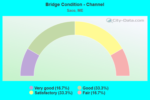
- Bridge Condition - Channel
- 16.7%Very good
- 33.3%Good
- 33.3%Satisfactory
- 16.7%Fair
Find on map >> Show street view
Structure Number: 1341, Location: 0.319 mi NW of Main St (Lat: 43.498869, Lng: -70.488011), Route carried "on" structure: Interstate 95, Year Built: 1947, Status: Open, Structure Length: 18.90m (62.01ft), Average Daily Traffic: 34,410 (year 2016), Truck Traffic: 5%, Average Future Daily Traffic: 48,174 (year 2036), Design Load: HL 93, Features Intersected: SACO RIVER
Minimum Vertical Clearance: 30+ m (98+ ft), Kilometerpoint: 52.111, Lanes on structure: 3, Base Highway Network: Yes, Toll: On Interstate toll segment, Owner: State Toll Authority, Approaching Roadway Width: 18.5m (60.7ft), Skew: 2 degrees, Material/Design: Steel continuous, Design/Construction: Stringer/Multi-beam, Number Of Spans In Main Unit: 6, Length of Maximum Span: 33.5m (109.9ft), Curb or Sidewalk Widths: Left: 0.2m (0.7ft), Right: 0.2m (0.7ft), Curb-To-Curb Width: 18.5m (60.7ft), Out-to-Out Width: 19.7m (64.6ft)
Condition: Deck: Good, Superstructure: Fair, Substructure: Satisfactory, Channel: Good, Operating Rating: 45.7 metric tons, Method Used To Determine Operating Rating: Load and Resistance Factor Rating (LRFR) rating reported by rating factor(RF) method using HL-93 loadings, Inventory Rating: 35.3 metric tons, Method Used To Determine Inventory Rating: Load and Resistance Factor Rating (LRFR) rating reported by rating factor(RF) method using HL-93 loadings, Structural Evaluation: Somewhat better than minimum adequacy, Deck Geometry: Superior to present desirable criteria, Waterway Adequacy: Superior to present desirable criteria, Approach Roadway Alignment: Equal to present desirable criteria, Designated Inspection Frequency: Every 24 months, Underwater Inspection Frequency: Every 60 months, Inspection Date: May 2021, Underwater Inspection Date: June 2021, Deck Structure Type: Concrete Cast-file-Place, Wearing Surface/Protective System: Wearing Surface: Bituminous, Membrane: Preformed Fabric
Find on map >> Show street view
Structure Number: 1342, Location: 0.036 mi SE of Berry Rd (Lat: 43.503611, Lng: -70.484311), Route carried "on" structure: City street , Year Built: 1995, Status: Open, Structure Length: 5.89m (19.32ft), Average Daily Traffic: 1,070 (year 2016), Truck Traffic: 5%, Average Future Daily Traffic: 1,605 (year 2036), Design Load: HL 93, Features Intersected: I-95, Facility Carried by Structure: BOOM ROAD
Minimum Vertical Clearance: 30+ m (98+ ft), Kilometerpoint: 8.803, Lanes on structure: 2, Lanes under structure: 6, Owner: State Toll Authority, Approaching Roadway Width: 9.8m (32.2ft), Skew: 1 degrees, Material/Design: Steel continuous, Design/Construction: Stringer/Multi-beam, Number Of Spans In Main Unit: 2, Length of Maximum Span: 29.9m (98.1ft), Curb-To-Curb Width: 9.8m (32.2ft), Out-to-Out Width: 10.7m (35.1ft)
Condition: Deck: Good, Superstructure: Good, Substructure: Good, Operating Rating: 39.2 metric tons, Method Used To Determine Operating Rating: Load and Resistance Factor Rating (LRFR) rating reported by rating factor(RF) method using HL-93 loadings, Inventory Rating: 30.1 metric tons, Method Used To Determine Inventory Rating: Load and Resistance Factor Rating (LRFR) rating reported by rating factor(RF) method using HL-93 loadings, Structural Evaluation: Better than present minimum criteria, Deck Geometry: Somewhat better than minimum adequacy, Underclear: Meets minimum limits, Approach Roadway Alignment: Equal to present desirable criteria, Designated Inspection Frequency: Every 24 months, Inspection Date: April 2021, Deck Structure Type: Concrete Cast-file-Place, Wearing Surface/Protective System: Wearing Surface: Bituminous, Membrane: Preformed Fabric, Deck Protection: Epoxy Coated Reinforcing
Find on map >> Show street view
Structure Number: 1343, Location: 0.108 mi W of Shadagee (Lat: 43.514361, Lng: -70.470339), Route carried "on" structure: County highway 5, Year Built: 2000, Status: Open, Structure Length: 5.67m (18.60ft), Average Daily Traffic: 4,850 (year 2016), Truck Traffic: 5%, Average Future Daily Traffic: 6,790 (year 2036), Design Load: HL 93, Features Intersected: I-95
Minimum Vertical Clearance: 30+ m (98+ ft), Kilometerpoint: 10.332, Lanes on structure: 2, Lanes under structure: 6, Owner: State Toll Authority, Approaching Roadway Width: 9.8m (32.2ft), Material/Design: Steel continuous, Design/Construction: Stringer/Multi-beam, Number Of Spans In Main Unit: 2, Length of Maximum Span: 28.3m (92.8ft), Curb-To-Curb Width: 9.8m (32.2ft), Out-to-Out Width: 10.7m (35.1ft)
Condition: Deck: Satisfactory, Superstructure: Good, Substructure: Good, Operating Rating: 43.7 metric tons, Method Used To Determine Operating Rating: Load and Resistance Factor Rating (LRFR) rating reported by rating factor(RF) method using HL-93 loadings, Inventory Rating: 33.7 metric tons, Method Used To Determine Inventory Rating: Load and Resistance Factor Rating (LRFR) rating reported by rating factor(RF) method using HL-93 loadings, Structural Evaluation: Better than present minimum criteria, Deck Geometry: Meets minimum limits, Underclear: Equal to present minimum criteria, Approach Roadway Alignment: Equal to present desirable criteria, Designated Inspection Frequency: Every 24 months, Inspection Date: April 2021, Deck Structure Type: Concrete Cast-file-Place, Wearing Surface/Protective System: Wearing Surface: Bituminous, Membrane: Preformed Fabric, Deck Protection: Epoxy Coated Reinforcing
Find on map >> Show street view
Structure Number: 1345, Location: 0.274 mi W of Lund Rd (Lat: 43.522531, Lng: -70.459150), Route carried "on" structure: County highway 112, Year Built: 2002, Status: Open, Structure Length: 6.00m (19.69ft), Average Daily Traffic: 12,094 (year 2016), Truck Traffic: 5%, Average Future Daily Traffic: 16,932 (year 2036), Design Load: HL 93, Features Intersected: I-95
Minimum Vertical Clearance: 30+ m (98+ ft), Kilometerpoint: 2.543, Lanes on structure: 2, Lanes under structure: 7, Owner: State Toll Authority, Approaching Roadway Width: 12.2m (40.0ft), Material/Design: Steel continuous, Design/Construction: Stringer/Multi-beam, Number Of Spans In Main Unit: 2, Length of Maximum Span: 31.8m (104.3ft), Curb or Sidewalk Widths: Left: 0.0m, Right: 1.8m (5.9ft), Curb-To-Curb Width: 12.2m (40.0ft), Out-to-Out Width: 14.8m (48.6ft)
Condition: Deck: Good, Superstructure: Good, Substructure: Good, Operating Rating: 43.4 metric tons, Method Used To Determine Operating Rating: Load and Resistance Factor Rating (LRFR) rating reported by rating factor(RF) method using HL-93 loadings, Inventory Rating: 33.7 metric tons, Method Used To Determine Inventory Rating: Load and Resistance Factor Rating (LRFR) rating reported by rating factor(RF) method using HL-93 loadings, Structural Evaluation: Better than present minimum criteria, Deck Geometry: Somewhat better than minimum adequacy, Underclear: Equal to present minimum criteria, Approach Roadway Alignment: Equal to present desirable criteria, Designated Inspection Frequency: Every 24 months, Inspection Date: April 2021, Deck Structure Type: Concrete Cast-file-Place, Wearing Surface/Protective System: Wearing Surface: Bituminous, Membrane: Preformed Fabric, Deck Protection: Epoxy Coated Reinforcing
Find on map >> Show street view
Structure Number: 1347, Location: 0.476 mi E of Jenkins Rd (Lat: 43.553931, Lng: -70.424989), Route carried "on" structure: City street , Year Built: 2000, Status: Open, Structure Length: 7.96m (26.12ft), Average Daily Traffic: 2,900 (year 2016), Truck Traffic: 5%, Average Future Daily Traffic: 4,060 (year 2036), Design Load: HL 93, Features Intersected: I-95, Facility Carried by Structure: FLAG POND ROAD
Minimum Vertical Clearance: 30+ m (98+ ft), Kilometerpoint: 0.000, Lanes on structure: 2, Lanes under structure: 6, Owner: State Toll Authority, Approaching Roadway Width: 9.8m (32.2ft), Skew: 3 degrees, Material/Design: Steel continuous, Design/Construction: Stringer/Multi-beam, Number Of Spans In Main Unit: 2, Length of Maximum Span: 39.8m (130.6ft), Curb-To-Curb Width: 9.8m (32.2ft), Out-to-Out Width: 10.7m (35.1ft)
Condition: Deck: Good, Superstructure: Satisfactory, Substructure: Good, Operating Rating: 38.6 metric tons, Method Used To Determine Operating Rating: Load and Resistance Factor Rating (LRFR) rating reported by rating factor(RF) method using HL-93 loadings, Inventory Rating: 29.8 metric tons, Method Used To Determine Inventory Rating: Load and Resistance Factor Rating (LRFR) rating reported by rating factor(RF) method using HL-93 loadings, Structural Evaluation: Equal to present minimum criteria, Deck Geometry: Meets minimum limits, Underclear: Equal to present minimum criteria, Approach Roadway Alignment: Superior to present desirable criteria, Designated Inspection Frequency: Every 24 months, Inspection Date: April 2021, Deck Structure Type: Concrete Cast-file-Place, Wearing Surface/Protective System: Wearing Surface: Bituminous, Membrane: Preformed Fabric, Deck Protection: Epoxy Coated Reinforcing
Find on map >> Show street view
Structure Number: 1352, Location: .1 MI E US 1 (Lat: 43.496061, Lng: -70.446081), Year Built: 1928, Status: Open, Structure Length: 1.52m (4.99ft), Average Future Daily Traffic: 366 (year 2034), Design Load: Railroad, Features Intersected: FRONT ST-TW
Lanes under structure: 1, Owner: Railroad, Material/Design: Steel, Design/Construction: Girder and Floorbeam System, Number Of Spans In Main Unit: 1, Length of Maximum Span: 12.8m (42.0ft), Out-to-Out Width: 9.1m (29.9ft)
Condition: Substructure: Satisfactory, Operating Rating: 79.8 metric tons, Method Used To Determine Operating Rating: Load Factor (LF), Inventory Rating: 79.8 metric tons, Method Used To Determine Inventory Rating: Load Factor (LF), Structural Evaluation: Equal to present minimum criteria, Underclear: High priority of corrective action, Designated Inspection Frequency: Every 24 months, Inspection Date: October 2021
Find on map >> Show street view
Structure Number: 1353, Location: 150 FT S COMMON ST (Lat: 43.496131, Lng: -70.444261), Year Built: 1928, Status: Open, Structure Length: 1.59m (5.22ft), Average Future Daily Traffic: 131 (year 2034), Design Load: Railroad, Features Intersected: WHARF ST-TW
Lanes under structure: 2, Owner: Railroad, Material/Design: Steel, Design/Construction: Stringer/Multi-beam, Number Of Spans In Main Unit: 1, Length of Maximum Span: 12.2m (40.0ft), Out-to-Out Width: 7.6m (24.9ft)
Condition: Substructure: Fair, Underclear: Somewhat better than minimum adequacy, Designated Inspection Frequency: Every 24 months, Inspection Date: November 2021
Find on map >> Show street view
Structure Number: 1354, Location: .5 MI S JCT 9 (Lat: 43.496439, Lng: -70.442339), Year Built: 1928, Year Reconstructed: 1997, Status: Open, Structure Length: 5.00m (16.40ft), Average Future Daily Traffic: 3,287 (year 2034), Design Load: Railroad, Features Intersected: COMMON ST-TW
Lanes under structure: 2, Owner: Railroad, Skew: 5 degrees, Material/Design: Steel, Design/Construction: Girder and Floorbeam System, Number Of Spans In Main Unit: 2, Length of Maximum Span: 22.9m (75.1ft), Out-to-Out Width: 8.8m (28.9ft)
Condition: Substructure: Fair, Operating Rating: 79.8 metric tons, Method Used To Determine Operating Rating: Load Factor (LF), Inventory Rating: 79.8 metric tons, Method Used To Determine Inventory Rating: Load Factor (LF), Structural Evaluation: Somewhat better than minimum adequacy, Underclear: High priority of corrective action, Designated Inspection Frequency: Every 24 months, Inspection Date: October 2021
Find on map >> Show street view
Structure Number: 1355, Location: .4 MI S JCT 9 (Lat: 43.497100, Lng: -70.438700), Year Built: 1928, Status: Open, Structure Length: 1.92m (6.30ft), Average Future Daily Traffic: 3,268 (year 2034), Design Load: Railroad, Features Intersected: JAMES ST-TW
Lanes under structure: 2, Owner: Railroad, Skew: 4 degrees, Material/Design: Steel, Design/Construction: Girder and Floorbeam System, Number Of Spans In Main Unit: 1, Length of Maximum Span: 10.4m (34.1ft), Out-to-Out Width: 8.5m (27.9ft)
Condition: Substructure: Fair, Underclear: High priority of corrective action, Designated Inspection Frequency: Every 24 months, Inspection Date: March 2021
Find on map >> Show street view
Structure Number: 1364, Location: .5 MI E RTE 1 (Lat: 43.498789, Lng: -70.433819), Year Built: 1928, Status: Open, Structure Length: 1.62m (5.31ft), Average Future Daily Traffic: 17,051 (year 2034), Design Load: Railroad, Features Intersected: BEACH ST-RTE #9
Lanes under structure: 2, Owner: Railroad, Skew: 2 degrees, Material/Design: Steel, Design/Construction: Girder and Floorbeam System, Number Of Spans In Main Unit: 1, Length of Maximum Span: 14.3m (46.9ft), Curb or Sidewalk Widths: Left: 0.0m, Right: 2.9m (9.5ft), Out-to-Out Width: 8.3m (27.2ft)
Condition: Substructure: Satisfactory, Operating Rating: 79.8 metric tons, Method Used To Determine Operating Rating: Load Factor (LF), Inventory Rating: 79.8 metric tons, Method Used To Determine Inventory Rating: Load Factor (LF), Structural Evaluation: Equal to present minimum criteria, Underclear: High priority of corrective action, Designated Inspection Frequency: Every 24 months, Inspection Date: December 2021
Find on map >> Show street view
Structure Number: 1365, Location: 1.8 MI NW JCT 9 (Lat: 43.502881, Lng: -70.415569), Year Built: 1927, Status: Open, Structure Length: 1.16m (3.81ft), Average Future Daily Traffic: 5,524 (year 2034), Design Load: Railroad, Features Intersected: OLD ORCHARD RD
Lanes under structure: 2, Owner: Railroad, Skew: 2 degrees, Material/Design: Steel, Design/Construction: Girder and Floorbeam System, Number Of Spans In Main Unit: 1, Length of Maximum Span: 9.8m (32.2ft), Out-to-Out Width: 7.3m (24.0ft)
Condition: Substructure: Satisfactory, Operating Rating: 79.8 metric tons, Method Used To Determine Operating Rating: Load Factor (LF), Inventory Rating: 79.8 metric tons, Method Used To Determine Inventory Rating: Load Factor (LF), Structural Evaluation: Equal to present minimum criteria, Underclear: High priority of corrective action, Designated Inspection Frequency: Every 24 months, Inspection Date: November 2021
Find on map >> Show street view
Structure Number: 1483, Location: 0.334 mi NW of Main St (Lat: 43.498869, Lng: -70.488219), Route carried "on" structure: Interstate 95, Year Built: 1948, Year Reconstructed: 1971, Status: Open, Structure Length: 18.90m (62.01ft), Average Daily Traffic: 35,170 (year 2016), Truck Traffic: 5%, Average Future Daily Traffic: 49,238 (year 2036), Design Load: HL 93, Features Intersected: SACO RIVER
Minimum Vertical Clearance: 30+ m (98+ ft), Kilometerpoint: 434.846, Lanes on structure: 3, Base Highway Network: Yes, Toll: On Interstate toll segment, Owner: State Toll Authority, Approaching Roadway Width: 18.5m (60.7ft), Skew: 2 degrees, Material/Design: Steel continuous, Design/Construction: Stringer/Multi-beam, Number Of Spans In Main Unit: 6, Length of Maximum Span: 33.5m (109.9ft), Curb or Sidewalk Widths: Left: 0.2m (0.7ft), Right: 0.2m (0.7ft), Curb-To-Curb Width: 18.5m (60.7ft), Out-to-Out Width: 19.7m (64.6ft)
Condition: Deck: Good, Superstructure: Fair, Substructure: Satisfactory, Channel: Fair, Operating Rating: 45.7 metric tons, Method Used To Determine Operating Rating: Load and Resistance Factor Rating (LRFR) rating reported by rating factor(RF) method using HL-93 loadings, Inventory Rating: 35.3 metric tons, Method Used To Determine Inventory Rating: Load and Resistance Factor Rating (LRFR) rating reported by rating factor(RF) method using HL-93 loadings, Structural Evaluation: Somewhat better than minimum adequacy, Deck Geometry: Superior to present desirable criteria, Waterway Adequacy: Superior to present desirable criteria, Approach Roadway Alignment: Equal to present desirable criteria, Designated Inspection Frequency: Every 24 months, Underwater Inspection Frequency: Every 60 months, Inspection Date: June 2021, Underwater Inspection Date: June 2021, Deck Structure Type: Concrete Cast-file-Place, Wearing Surface/Protective System: Wearing Surface: Bituminous, Membrane: Preformed Fabric
Find on map >> Show street view
Structure Number: 2137, Location: 0.2 MI N OF BIDDEFORD (Lat: 43.496219, Lng: -70.447581), Route carried "on" structure: County highway 9, Year Built: 1943, Year Reconstructed: 1996, Status: Open, Structure Length: 3.23m (10.60ft), Average Daily Traffic: 20,390 (year 2016), Truck Traffic: 5%, Average Future Daily Traffic: 28,546 (year 2036), Design Load: HS 25 or greater, Features Intersected: NE CHANNEL SACO RIVER
Minimum Vertical Clearance: 30+ m (98+ ft), Kilometerpoint: 61.107, Lanes on structure: 3, Owner: State Highway Agency, Approaching Roadway Width: 16.5m (54.1ft), Skew: 5 degrees, Material/Design: Steel, Design/Construction: Stringer/Multi-beam, Number Of Spans In Main Unit: 1, Number Of Approach Spans: 1, Length of Maximum Span: 27.4m (89.9ft), Curb or Sidewalk Widths: Left: 1.9m (6.2ft), Right: 1.9m (6.2ft), Curb-To-Curb Width: 12.8m (42.0ft), Out-to-Out Width: 17.3m (56.8ft)
Condition: Deck: Good, Superstructure: Good, Substructure: Fair, Channel: Very good, Operating Rating: 33.0 metric tons, Method Used To Determine Operating Rating: Load and Resistance Factor Rating (LRFR) rating reported by rating factor(RF) method using HL-93 loadings, Inventory Rating: 25.6 metric tons, Method Used To Determine Inventory Rating: Load and Resistance Factor Rating (LRFR) rating reported by rating factor(RF) method using HL-93 loadings, Structural Evaluation: Somewhat better than minimum adequacy, Deck Geometry: Meets minimum limits, Waterway Adequacy: Superior to present desirable criteria, Approach Roadway Alignment: Better than present minimum criteria, Designated Inspection Frequency: Every 24 months, Underwater Inspection Frequency: Every 60 months, Inspection Date: November 2021, Underwater Inspection Date: November 2019, Deck Structure Type: Concrete Cast-file-Place, Wearing Surface/Protective System: Wearing Surface: Bituminous, Membrane: Preformed Fabric
Find on map >> Show street view
Structure Number: 2603, Location: BIDDEFORD - SACO TL (Lat: 43.540011, Lng: -70.514839), Route carried "on" structure: State highway 5, Year Built: 1997, Status: Open, Structure Length: 10.06m (33.01ft), Average Daily Traffic: 5,530 (year 2016), Truck Traffic: 5%, Average Future Daily Traffic: 7,742 (year 2036), Design Load: HS 25 or greater, Features Intersected: SACO RIVER
Minimum Vertical Clearance: 30+ m (98+ ft), Kilometerpoint: 15.031, Lanes on structure: 2, Owner: State Highway Agency, Approaching Roadway Width: 10.4m (34.1ft), Skew: 1 degrees, Material/Design: Steel continuous, Design/Construction: Stringer/Multi-beam, Number Of Spans In Main Unit: 2, Length of Maximum Span: 49.4m (162.1ft), Curb or Sidewalk Widths: Left: 0.1m (0.3ft), Right: 0.1m (0.3ft), Curb-To-Curb Width: 9.1m (29.9ft), Out-to-Out Width: 10.7m (35.1ft)
Condition: Deck: Good, Superstructure: Good, Substructure: Satisfactory, Channel: Satisfactory, Operating Rating: 42.8 metric tons, Method Used To Determine Operating Rating: Load and Resistance Factor Rating (LRFR) rating reported by rating factor(RF) method using HL-93 loadings, Inventory Rating: 33.0 metric tons, Method Used To Determine Inventory Rating: Load and Resistance Factor Rating (LRFR) rating reported by rating factor(RF) method using HL-93 loadings, Structural Evaluation: Equal to present minimum criteria, Deck Geometry: Meets minimum limits, Waterway Adequacy: Superior to present desirable criteria, Approach Roadway Alignment: Equal to present desirable criteria, Designated Inspection Frequency: Every 24 months, Underwater Inspection Frequency: Every 60 months, Inspection Date: March 2021, Underwater Inspection Date: August 2019, Deck Structure Type: Concrete Cast-file-Place, Wearing Surface/Protective System: Wearing Surface: Bituminous, Membrane: Preformed Fabric
Find on map >> Show street view
Structure Number: 3412, Location: SACO / BIDDEFORD TL (Lat: 43.499181, Lng: -70.456450), Route carried "on" structure: County highway , Year Built: 2016, Status: Open, Structure Length: 10.49m (34.42ft), Average Daily Traffic: 5,532 (year 2016), Truck Traffic: 5%, Average Future Daily Traffic: 7,745 (year 2036), Design Load: Greater than HL93, Features Intersected: SACO RIVER (E OR N CHAN), Facility Carried by Structure: PINE & MARKET ST'S
Minimum Vertical Clearance: 30+ m (98+ ft), Kilometerpoint: 0.193, Lanes on structure: 2, Owner: State Highway Agency, Approaching Roadway Width: 9.8m (32.2ft), Material/Design: Steel continuous, Design/Construction: Stringer/Multi-beam, Number Of Spans In Main Unit: 2, Length of Maximum Span: 51.8m (169.9ft), Curb or Sidewalk Widths: Left: 1.5m (4.9ft), Right: 0.0m, Curb-To-Curb Width: 9.8m (32.2ft), Out-to-Out Width: 12.3m (40.4ft)
Condition: Deck: Good, Superstructure: Very good, Substructure: Very good, Channel: Good, Operating Rating: 48.6 metric tons, Method Used To Determine Operating Rating: Load and Resistance Factor Rating (LRFR) rating reported by rating factor(RF) method using HL-93 loadings, Inventory Rating: 37.3 metric tons, Method Used To Determine Inventory Rating: Load and Resistance Factor Rating (LRFR) rating reported by rating factor(RF) method using HL-93 loadings, Structural Evaluation: Equal to present desirable criteria, Deck Geometry: Meets minimum limits, Waterway Adequacy: Superior to present desirable criteria, Approach Roadway Alignment: Equal to present desirable criteria, Designated Inspection Frequency: Every 24 months, Underwater Inspection Frequency: Every 60 months, Inspection Date: August 2021, Underwater Inspection Date: June 2020, Deck Structure Type: Concrete Cast-file-Place, Wearing Surface/Protective System: Wearing Surface: Bituminous, Membrane: Preformed Fabric
Find on map >> Show street view
Structure Number: 3643, Location: 1.5 MI S OF JCT RTE 5 (Lat: 43.497469, Lng: -70.387931), Route carried "on" structure: County highway 9, Year Built: 1948, Status: Open, Structure Length: 1.98m (6.50ft), Average Daily Traffic: 2,930 (year 2016), Truck Traffic: 5%, Average Future Daily Traffic: 4,102 (year 2036), Design Load: H 15, Features Intersected: GOOSE FARE CREEK
Minimum Vertical Clearance: 30+ m (98+ ft), Kilometerpoint: 71.584, Lanes on structure: 2, Owner: State Highway Agency, Approaching Roadway Width: 8.8m (28.9ft), Material/Design: Steel, Design/Construction: Stringer/Multi-beam, Number Of Spans In Main Unit: 1, Length of Maximum Span: 18.3m (60.0ft), Curb or Sidewalk Widths: Left: 0.2m (0.7ft), Right: 1.5m (4.9ft), Curb-To-Curb Width: 7.3m (24.0ft), Out-to-Out Width: 9.6m (31.5ft)
Condition: Deck: Fair, Superstructure: Fair, Substructure: Fair, Channel: Satisfactory, Operating Rating: 36.3 metric tons, Method Used To Determine Operating Rating: Load and Resistance Factor Rating (LRFR) rating reported by rating factor(RF) method using HL-93 loadings, Inventory Rating: 28.2 metric tons, Method Used To Determine Inventory Rating: Load and Resistance Factor Rating (LRFR) rating reported by rating factor(RF) method using HL-93 loadings, Structural Evaluation: Somewhat better than minimum adequacy, Deck Geometry: High priority of replacement, Waterway Adequacy: Equal to present desirable criteria, Approach Roadway Alignment: Equal to present desirable criteria, Designated Inspection Frequency: Every 24 months, Inspection Date: March 2021, Deck Structure Type: Concrete Cast-file-Place, Wearing Surface/Protective System: Wearing Surface: Integral Concrete
Find on map >> Show street view
Location: 0.216 mi NW of Saratoga (Lat: 43.574300, Lng: -70.403281), Route carried "under" structure: Business US 82110, Structure Length: 0. m, Average Daily Traffic: 34,920 (year 2014), Truck Traffic: 11%, Features Intersected: BROADTURN ROAD, Facility Carried by Structure: I-95
Minimum Vertical Clearance: 5.03m (16.50ft), Kilometerpoint: 63.118, Lanes on structure: 6, Toll: On Interstate toll segment, Length of Maximum Span: 0.0m
Find on map >> Show street view
Location: 0.268 mi E of Chelsea (Lat: 43.527678, Lng: -70.452803), Route carried "under" structure: Other road 82110, Structure Length: 0. m, Average Daily Traffic: 26,440 (year 2014), Truck Traffic: 10%, Features Intersected: SACO INTER (WB), Facility Carried by Structure: I-95
Minimum Vertical Clearance: 5.11m (16.77ft), Kilometerpoint: 56.762, Lanes on structure: 5, Toll: On Interstate toll segment, Length of Maximum Span: 0.0m
Find on map >> Show street view
Location: 0.138 mi W of Cathedral (Lat: 43.500000, Lng: -70.500000), Route carried "on" structure: Spur State highway 2110, Structure Length: 0. m, Average Daily Traffic: 31,780 (year 2014), Truck Traffic: 11%, Features Intersected: SOUTH ST, Facility Carried by Structure: INT 95 NB
Minimum Vertical Clearance: 4.29m (14.07ft), Kilometerpoint: 51.740, Lanes on structure: 4, Toll: On Interstate toll segment, Length of Maximum Span: 0.0m
Find on map >> Show street view
Location: 0.036 mi SE of Berry Rd (Lat: 43.503611, Lng: -70.484306), Route carried "on" structure: Spur State highway 22110, Structure Length: 0. m, Average Daily Traffic: 31,780 (year 2014), Truck Traffic: 11%, Features Intersected: BOOM ROAD, Facility Carried by Structure: I-95
Minimum Vertical Clearance: 5.03m (16.50ft), Kilometerpoint: 52.899, Lanes on structure: 4, Toll: On Interstate toll segment, Length of Maximum Span: 0.0m
Find on map >> Show street view
Location: 0.108 mi W of Shadagee (Lat: 43.514356, Lng: -70.470342), Route carried "on" structure: Spur State highway 32110, Structure Length: 0. m, Average Daily Traffic: 31,780 (year 2014), Truck Traffic: 11%, Features Intersected: NEW COUNTY RD/RT 5, Facility Carried by Structure: I-95
Minimum Vertical Clearance: 5.03m (16.50ft), Kilometerpoint: 54.541, Lanes on structure: 4, Toll: On Interstate toll segment, Length of Maximum Span: 0.0m
Find on map >> Show street view
Location: 0.274 mi W of Lund Rd (Lat: 43.522525, Lng: -70.459144), Route carried "on" structure: Spur State highway 52110, Structure Length: 0. m, Average Daily Traffic: 31,780 (year 2014), Truck Traffic: 10%, Features Intersected: NORTH ST/RTE 112, Facility Carried by Structure: I-95
Minimum Vertical Clearance: 4.39m (14.40ft), Kilometerpoint: 55.860, Lanes on structure: 4, Toll: On Interstate toll segment, Length of Maximum Span: 0.0m
Find on map >> Show street view
Location: 0.476 mi E of Jenkins Rd (Lat: 43.553931, Lng: -70.424992), Route carried "on" structure: Spur State highway 72110, Structure Length: 0. m, Average Daily Traffic: 34,920 (year 2014), Truck Traffic: 11%, Features Intersected: FLAG POND ROAD, Facility Carried by Structure: I-95
Minimum Vertical Clearance: 5.03m (16.50ft), Kilometerpoint: 60.318, Lanes on structure: 6, Toll: On Interstate toll segment, Length of Maximum Span: 0.0m
Find on map >> Show street view
Location: 1MI S I-295 (Lat: 43.623819, Lng: -70.470342), Route carried "on" structure: City street 22310, Structure Length: 0. m, Average Daily Traffic: 7,970 (year 2014), Truck Traffic: 7%, Features Intersected: SB RT 1 CONNECT, Facility Carried by Structure: STATE ROUTE 703
Minimum Vertical Clearance: 4.52m (14.83ft), Kilometerpoint: 1.191, Lanes on structure: 5, Length of Maximum Span: 0.0m