Bridge Statistics for Saddle Brook, New Jersey (NJ)
Condition, Traffic, Stress, Structural Evaluation, Project Costs
- National Bridge Inventory (NBI) Statistics
- 31Number of bridges
- 397ft / 121mTotal length
- $1,950,000Total costs
- 1,201,076Total average daily traffic
- 64,304Total average daily truck traffic
- National Bridge Inventory (NBI) Registered Bridges for Saddle Brook
- No street view available for this location
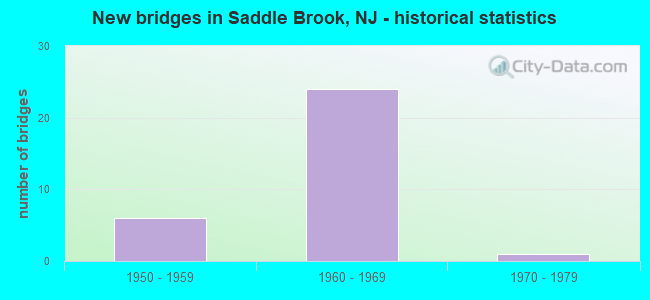
- New bridges - historical statistics
- 61950-1959
- 241960-1969
- 11970-1979
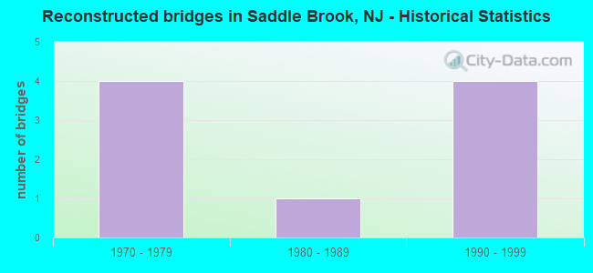
- Reconstructed bridges - Historical Statistics
- 41970-1979
- 11980-1989
- 41990-1999
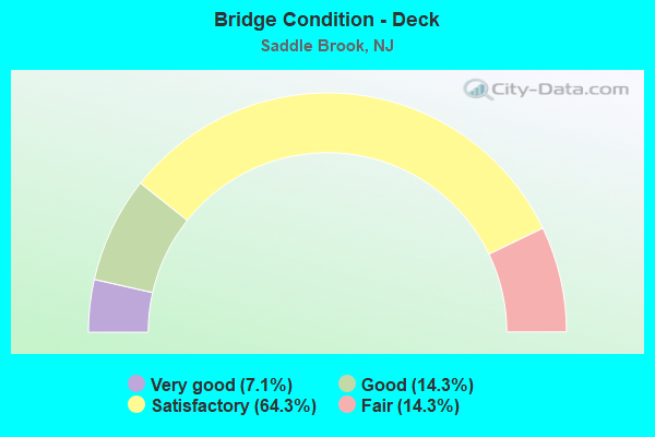
- Bridge Condition - Deck
- 7.1%Very good
- 14.3%Good
- 64.3%Satisfactory
- 14.3%Fair
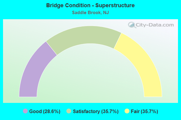
- Bridge Condition - Superstructure
- 28.6%Good
- 35.7%Satisfactory
- 35.7%Fair
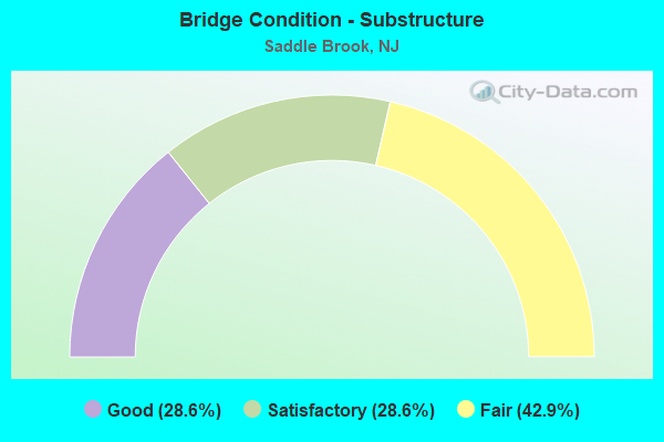
- Bridge Condition - Substructure
- 28.6%Good
- 28.6%Satisfactory
- 42.9%Fair
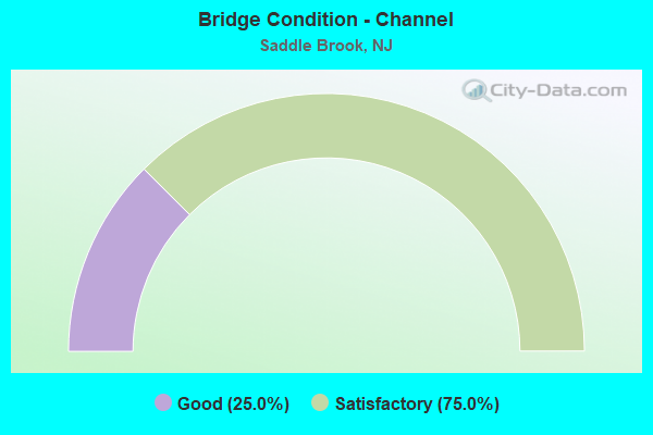
- Bridge Condition - Channel
- 25.0%Good
- 75.0%Satisfactory
Find on map >> Show street view
Structure Number: 20054A, Location: 0.01 mi East of CR 79 (Lat: 40.900250, Lng: -74.081500), Route carried "on" structure: County highway S61, Year Built: 1971, Status: Open, Structure Length: 3.84m (12.60ft), Average Daily Traffic: 12,540 (year 2020), Truck Traffic: 4%, Average Future Daily Traffic: 15,050 (year 2040), Design Load: HS 20, Features Intersected: SADDLE RIVER
Minimum Vertical Clearance: 30+ m (98+ ft), Kilometerpoint: 0.013, Lanes on structure: 2, Owner: County Highway Agency, Approaching Roadway Width: 9.1m (29.9ft), Skew: 2 degrees, Material/Design: Steel, Design/Construction: Stringer/Multi-beam, Number Of Spans In Main Unit: 2, Length of Maximum Span: 18.3m (60.0ft), Curb or Sidewalk Widths: Left: 1.8m (5.9ft), Right: 1.8m (5.9ft), Curb-To-Curb Width: 9.1m (29.9ft), Out-to-Out Width: 13.4m (44.0ft)
Condition: Deck: Satisfactory, Superstructure: Satisfactory, Substructure: Satisfactory, Channel: Satisfactory, Operating Rating: 84.4 metric tons, Method Used To Determine Operating Rating: Load Factor (LF), Inventory Rating: 50.8 metric tons, Method Used To Determine Inventory Rating: Load Factor (LF), Structural Evaluation: Equal to present minimum criteria, Deck Geometry: High priority of corrective action, Waterway Adequacy: Equal to present minimum criteria, Approach Roadway Alignment: Equal to present minimum criteria, Length Of Structure Improvement: 3.84m (12.60ft), Designated Inspection Frequency: Every 24 months, Inspection Date: April 2020, Bridge Improvement Cost: $45,000, Roadway Improvement Cost: $106,000, Total Project Cost: $250,000 ( Estimate for 2020), Deck Structure Type: Concrete Cast-file-Place, Wearing Surface/Protective System: Wearing Surface: Monolithic Concrete
Find on map >> Show street view
Structure Number: 22516, Location: 0.4 MI EAST OF GR ST PKY (Lat: 40.902981, Lng: -74.097811), Route carried "on" structure: Ramp Interstate 80, Year Built: 1964, Year Reconstructed: 1991, Status: Open, Structure Length: 8.96m (29.40ft), Average Daily Traffic: 14,586 (year 2020), Truck Traffic: 9%, Average Future Daily Traffic: 17,503 (year 2040), Design Load: HS 20, Features Intersected: ROUTE I-80 & RAMP CD, Facility Carried by Structure: RAMPS B & D
Minimum Vertical Clearance: 30+ m (98+ ft), Kilometerpoint: 100.327, Lanes on structure: 2, Lanes under structure: 10, Owner: State Highway Agency, Approaching Roadway Width: 12.8m (42.0ft), Skew: 33 degrees, Material/Design: Steel continuous, Design/Construction: Stringer/Multi-beam, Number Of Spans In Main Unit: 2, Number Of Approach Spans: 1, Length of Maximum Span: 32.3m (106.0ft), Curb-To-Curb Width: 14.9m (48.9ft), Out-to-Out Width: 17.2m (56.4ft)
Condition: Deck: Fair, Superstructure: Good, Substructure: Fair, Operating Rating: 76.2 metric tons, Method Used To Determine Operating Rating: Load Factor (LF), Inventory Rating: 45.4 metric tons, Method Used To Determine Inventory Rating: Load Factor (LF), Structural Evaluation: Somewhat better than minimum adequacy, Deck Geometry: Superior to present desirable criteria, Underclear: High priority of corrective action, Approach Roadway Alignment: Equal to present minimum criteria, Length Of Structure Improvement: 8.96m (29.40ft), Designated Inspection Frequency: Every 24 months, Inspection Date: September 2020, Bridge Improvement Cost: $1,075,000, Roadway Improvement Cost: $115,000, Total Project Cost: $1,488,000 ( Estimate for 2020), Deck Structure Type: Concrete Cast-file-Place, Wearing Surface/Protective System: Wearing Surface: Latex Concrete, Deck Protection: Epoxy Coated Reinforcing
Find on map >> Show street view
Structure Number: 225161, Location: 0.1 MI NORTH OF RTE I-80 (Lat: 40.904139, Lng: -74.098761), Route carried "on" structure: Ramp Interstate 80, Year Built: 1964, Status: Open, Structure Length: 2.29m (7.51ft), Average Daily Traffic: 22,093 (year 2020), Truck Traffic: 9%, Average Future Daily Traffic: 26,512 (year 2040), Design Load: HS 20+Mod, Features Intersected: Ramp from I-80 WB to GSP
Minimum Vertical Clearance: 30+ m (98+ ft), Kilometerpoint: 100.182, Lanes on structure: 1, Lanes under structure: 1, Owner: State Highway Agency, Approaching Roadway Width: 7.3m (24.0ft), Skew: 6 degrees, Material/Design: Prestressed concrete, Design/Construction: Stringer/Multi-beam, Number Of Spans In Main Unit: 1, Length of Maximum Span: 21.9m (71.9ft), Curb-To-Curb Width: 7.3m (24.0ft), Out-to-Out Width: 8.4m (27.6ft)
Condition: Deck: Satisfactory, Superstructure: Good, Substructure: Fair, Operating Rating: 70.8 metric tons, Method Used To Determine Operating Rating: Load Factor (LF), Inventory Rating: 40.8 metric tons, Method Used To Determine Inventory Rating: Load Factor (LF), Structural Evaluation: Somewhat better than minimum adequacy, Deck Geometry: Better than present minimum criteria, Underclear: High priority of corrective action, Approach Roadway Alignment: Equal to present desirable criteria, Designated Inspection Frequency: Every 24 months, Inspection Date: August 2020, Deck Structure Type: Concrete Cast-file-Place, Wearing Surface/Protective System: Wearing Surface: Latex Concrete
Find on map >> Show street view
Structure Number: 225162, Location: 1.0 MI East of GDN ST PKY (Lat: 40.902131, Lng: -74.088800), Route carried "on" structure: City street , Year Built: 1962, Year Reconstructed: 2003, Status: Open, Structure Length: 8.05m (26.41ft), Average Daily Traffic: 6,331 (year 2020), Truck Traffic: 3%, Average Future Daily Traffic: 7,725 (year 2040), Design Load: HS 20+Mod, Features Intersected: ROUTE I-80, Facility Carried by Structure: MAYHILL STREET
Minimum Vertical Clearance: 30+ m (98+ ft), Kilometerpoint: 0.821, Lanes on structure: 2, Lanes under structure: 11, Owner: State Highway Agency, Approaching Roadway Width: 12.2m (40.0ft), Skew: 2 degrees, Material/Design: Steel, Design/Construction: Stringer/Multi-beam, Number Of Spans In Main Unit: 4, Length of Maximum Span: 30.5m (100.1ft), Curb or Sidewalk Widths: Left: 1.8m (5.9ft), Right: 0.0m, Curb-To-Curb Width: 12.4m (40.7ft), Out-to-Out Width: 15.1m (49.5ft)
Condition: Deck: Very good, Superstructure: Satisfactory, Substructure: Fair, Inventory Rating: 65.3 metric tons, Method Used To Determine Inventory Rating: Load Factor (LF), Structural Evaluation: Somewhat better than minimum adequacy, Deck Geometry: Somewhat better than minimum adequacy, Underclear: Meets minimum limits, Approach Roadway Alignment: Equal to present minimum criteria, Designated Inspection Frequency: Every 24 months, Inspection Date: March 2020, Deck Structure Type: Concrete Cast-file-Place, Wearing Surface/Protective System: Wearing Surface: Monolithic Concrete, Deck Protection: Epoxy Coated Reinforcing
Find on map >> Show street view
Structure Number: 225164, Location: 0.6 Mi. West of Exit 63 (Lat: 40.900589, Lng: -74.083639), Route carried "on" structure: Interstate 80, Year Built: 1960, Year Reconstructed: 2002, Status: Open, Structure Length: 27.10m (88.91ft), Average Daily Traffic: 75,450 (year 2020), Truck Traffic: 9%, Average Future Daily Traffic: 92,065 (year 2040), Design Load: HS 20+Mod, Features Intersected: SAD RV RD,RAMP B, NYS&W
Minimum Vertical Clearance: 30+ m (98+ ft), Kilometerpoint: 101.759, Lanes on structure: 5, Lanes under structure: 4, Base Highway Network: Yes, Owner: State Highway Agency, Approaching Roadway Width: 25.1m (82.3ft), Skew: 29 degrees, Material/Design: Steel, Design/Construction: Stringer/Multi-beam, Number Of Spans In Main Unit: 12, Length of Maximum Span: 29.0m (95.1ft), Curb-To-Curb Width: 25.1m (82.3ft), Out-to-Out Width: 26.8m (87.9ft)
Condition: Deck: Good, Superstructure: Good, Substructure: Fair, Operating Rating: 79.8 metric tons, Method Used To Determine Operating Rating: Load Factor (LF), Inventory Rating: 47.2 metric tons, Method Used To Determine Inventory Rating: Load Factor (LF), Structural Evaluation: Somewhat better than minimum adequacy, Deck Geometry: Better than present minimum criteria, Underclear: High priority of corrective action, Approach Roadway Alignment: Equal to present desirable criteria, Designated Inspection Frequency: Every 24 months, Critical Feature Inspection Frequency: Every 24 months, Inspection Date: July 2020, Critical Feature Inspection Date: July 2020, Deck Structure Type: Concrete Cast-file-Place, Wearing Surface/Protective System: Wearing Surface: Bituminous, Deck Protection: Epoxy Coated Reinforcing
Find on map >> Show street view
Structure Number: 225165, Location: 0.6 Mi. West of Exit 63 (Lat: 40.898869, Lng: -74.081081), Route carried "on" structure: Interstate 80, Year Built: 1960, Year Reconstructed: 2002, Status: Open, Structure Length: 24.84m (81.50ft), Average Daily Traffic: 75,450 (year 2020), Truck Traffic: 9%, Average Future Daily Traffic: 92,065 (year 2040), Design Load: HS 20+Mod, Features Intersected: SAD RV RD,RAMP B, NYS&W
Minimum Vertical Clearance: 30+ m (98+ ft), Kilometerpoint: 101.759, Lanes on structure: 4, Lanes under structure: 4, Base Highway Network: Yes, Owner: State Highway Agency, Approaching Roadway Width: 21.6m (70.9ft), Skew: 9 degrees, Material/Design: Steel, Design/Construction: Stringer/Multi-beam, Number Of Spans In Main Unit: 10, Length of Maximum Span: 29.0m (95.1ft), Curb-To-Curb Width: 21.6m (70.9ft), Out-to-Out Width: 22.8m (74.8ft)
Condition: Deck: Satisfactory, Superstructure: Good, Substructure: Fair, Operating Rating: 79.8 metric tons, Method Used To Determine Operating Rating: Load Factor (LF), Inventory Rating: 50.8 metric tons, Method Used To Determine Inventory Rating: Load Factor (LF), Structural Evaluation: Somewhat better than minimum adequacy, Deck Geometry: Better than present minimum criteria, Underclear: Meets minimum limits, Approach Roadway Alignment: Equal to present desirable criteria, Designated Inspection Frequency: Every 24 months, Critical Feature Inspection Frequency: Every 24 months, Inspection Date: July 2020, Critical Feature Inspection Date: July 2020, Deck Structure Type: Concrete Cast-file-Place, Wearing Surface/Protective System: Wearing Surface: Latex Concrete
Find on map >> Show street view
Structure Number: 225166, Location: 1.7 MI EAST OF GRD ST PKY (Lat: 40.895319, Lng: -74.079739), Route carried "on" structure: Interstate 80, Year Built: 1962, Year Reconstructed: 2003, Status: Open, Structure Length: 11.13m (36.52ft), Average Daily Traffic: 150,850 (year 2021), Truck Traffic: 9%, Average Future Daily Traffic: 181,020 (year 2041), Design Load: HS 20+Mod, Features Intersected: MRKT.MAIN.FRVW ST&SADRIV
Minimum Vertical Clearance: 30+ m (98+ ft), Kilometerpoint: 102.338, Lanes on structure: 11, Lanes under structure: 5, Base Highway Network: Yes, Owner: State Highway Agency, Approaching Roadway Width: 51.8m (169.9ft), Skew: 39 degrees, Material/Design: Steel, Design/Construction: Stringer/Multi-beam, Number Of Spans In Main Unit: 5, Length of Maximum Span: 39.9m (130.9ft), Curb-To-Curb Width: 53.2m (174.5ft), Out-to-Out Width: 55.4m (181.8ft)
Condition: Deck: Good, Superstructure: Satisfactory, Substructure: Fair, Channel: Good, Operating Rating: 63.5 metric tons, Method Used To Determine Operating Rating: Load Factor (LF), Inventory Rating: 37.2 metric tons, Method Used To Determine Inventory Rating: Load Factor (LF), Structural Evaluation: Somewhat better than minimum adequacy, Deck Geometry: Superior to present desirable criteria, Underclear: Meets minimum limits, Waterway Adequacy: Superior to present desirable criteria, Approach Roadway Alignment: Better than present minimum criteria, Length Of Structure Improvement: 3.35m (10.99ft), Designated Inspection Frequency: Every 24 months, Critical Feature Inspection Frequency: Every 24 months, Inspection Date: July 2021, Critical Feature Inspection Date: July 2021, Bridge Improvement Cost: $212,000, Total Project Cost: $212,000 ( Estimate for 2021), Deck Structure Type: Concrete Cast-file-Place, Wearing Surface/Protective System: Wearing Surface: Monolithic Concrete, Deck Protection: Epoxy Coated Reinforcing
Find on map >> Show street view
Structure Number: 361602A, Location: AT GSP & I-80 JUNCTION (Lat: 40.905903, Lng: -74.100942), Route carried "on" structure: County highway 105, Year Built: 1962, Status: Open, Structure Length: 7.50m (24.61ft), Average Daily Traffic: 13,750 (year 2020), Truck Traffic: 4%, Average Future Daily Traffic: 16,780 (year 2040), Design Load: H 20, Features Intersected: GSP INT.159 RAMPS, Facility Carried by Structure: PEHLE AVE
Minimum Vertical Clearance: 30+ m (98+ ft), Kilometerpoint: 0.515, Lanes on structure: 2, Lanes under structure: 5, Owner: State Toll Authority, Approaching Roadway Width: 13.4m (44.0ft), Skew: 1 degrees, Material/Design: Steel, Design/Construction: Stringer/Multi-beam, Number Of Spans In Main Unit: 5, Length of Maximum Span: 21.3m (69.9ft), Curb or Sidewalk Widths: Left: 0.0m, Right: 1.8m (5.9ft), Curb-To-Curb Width: 12.5m (41.0ft), Out-to-Out Width: 15.1m (49.5ft)
Condition: Deck: Satisfactory, Superstructure: Fair, Substructure: Satisfactory, Operating Rating: 25.9 metric tons, Method Used To Determine Operating Rating: Load and Resistance Factor Rating (LRFR) rating reported by rating factor(RF) method using HL-93 loadings, Inventory Rating: 20.1 metric tons, Method Used To Determine Inventory Rating: Load and Resistance Factor Rating (LRFR) rating reported by rating factor(RF) method using HL-93 loadings, Structural Evaluation: Somewhat better than minimum adequacy, Deck Geometry: Somewhat better than minimum adequacy, Underclear: High priority of corrective action, Approach Roadway Alignment: Equal to present minimum criteria, Designated Inspection Frequency: Every 24 months, Inspection Date: Febuary 2020, Deck Structure Type: Concrete Cast-file-Place, Wearing Surface/Protective System: Wearing Surface: Bituminous, Membrane: Preformed Fabric
Find on map >> Show street view
Structure Number: 361602B, Location: AT GSP & RT 80 JUNCTION (Lat: 40.904142, Lng: -74.099097), Route carried "on" structure: Ramp Other road GSP, Year Built: 1962, Status: Open, Structure Length: 3.20m (10.50ft), Average Daily Traffic: 13,840 (year 2020), Truck Traffic: 1%, Average Future Daily Traffic: 16,890 (year 2040), Design Load: H 20, Features Intersected: ENTRANCE RAMP X, Facility Carried by Structure: INT 159 RAMPS B&C
Minimum Vertical Clearance: 30+ m (98+ ft), Kilometerpoint: 257.817, Lanes on structure: 2, Lanes under structure: 1, Toll: On toll road, Owner: State Toll Authority, Approaching Roadway Width: 11.9m (39.0ft), Skew: 5 degrees, Material/Design: Steel, Design/Construction: Stringer/Multi-beam, Number Of Spans In Main Unit: 2, Length of Maximum Span: 20.7m (67.9ft), Curb-To-Curb Width: 12.0m (39.4ft), Out-to-Out Width: 12.9m (42.3ft)
Condition: Deck: Satisfactory, Superstructure: Fair, Substructure: Good, Operating Rating: 35.6 metric tons, Method Used To Determine Operating Rating: Load and Resistance Factor Rating (LRFR) rating reported by rating factor(RF) method using HL-93 loadings, Inventory Rating: 27.5 metric tons, Method Used To Determine Inventory Rating: Load and Resistance Factor Rating (LRFR) rating reported by rating factor(RF) method using HL-93 loadings, Structural Evaluation: Somewhat better than minimum adequacy, Deck Geometry: Superior to present desirable criteria, Underclear: Meets minimum limits, Approach Roadway Alignment: Somewhat better than minimum adequacy, Designated Inspection Frequency: Every 24 months, Inspection Date: Febuary 2020, Deck Structure Type: Concrete Cast-file-Place, Wearing Surface/Protective System: Wearing Surface: Bituminous
Find on map >> Show street view
Structure Number: 361602T, Location: AT GSP & I-80 JUNCTION (Lat: 40.906983, Lng: -74.101861), Route carried "on" structure: Ramp Other road GSP, Year Built: 1962, Status: Open, Structure Length: 6.52m (21.39ft), Average Daily Traffic: 8,007 (year 2020), Truck Traffic: 1%, Average Future Daily Traffic: 9,590 (year 2040), Design Load: H 20, Features Intersected: GARDEN ST PARKWAY, Facility Carried by Structure: INT 159 SB RAMP A
Minimum Vertical Clearance: 30+ m (98+ ft), Kilometerpoint: 257.817, Lanes on structure: 1, Lanes under structure: 6, Toll: On toll road, Owner: State Toll Authority, Approaching Roadway Width: 5.5m (18.0ft), Skew: 3 degrees, Material/Design: Steel, Design/Construction: Stringer/Multi-beam, Number Of Spans In Main Unit: 4, Length of Maximum Span: 22.6m (74.1ft), Curb-To-Curb Width: 5.5m (18.0ft), Out-to-Out Width: 7.1m (23.3ft)
Condition: Deck: Satisfactory, Superstructure: Fair, Substructure: Satisfactory, Operating Rating: 44.4 metric tons, Method Used To Determine Operating Rating: Load and Resistance Factor Rating (LRFR) rating reported by rating factor(RF) method using HL-93 loadings, Inventory Rating: 34.0 metric tons, Method Used To Determine Inventory Rating: Load and Resistance Factor Rating (LRFR) rating reported by rating factor(RF) method using HL-93 loadings, Structural Evaluation: Somewhat better than minimum adequacy, Deck Geometry: Meets minimum limits, Underclear: High priority of corrective action, Approach Roadway Alignment: Somewhat better than minimum adequacy, Designated Inspection Frequency: Every 24 months, Inspection Date: January 2020, Deck Structure Type: Concrete Cast-file-Place, Wearing Surface/Protective System: Wearing Surface: Bituminous
Find on map >> Show street view
Structure Number: 361606S, Location: 0.5 MI NE OF GSP& I80 JCT (Lat: 40.910617, Lng: -74.092900), Route carried "on" structure: Other road GSP, Year Built: 1954, Year Reconstructed: 1976, Status: Open, Structure Length: 3.35m (10.99ft), Average Daily Traffic: 71,689 (year 2020), Truck Traffic: 1%, Average Future Daily Traffic: 87,434 (year 2040), Design Load: H 20, Features Intersected: SADDLE RIVER RD (CR 79), Facility Carried by Structure: GARDEN ST PRKWY SB
Minimum Vertical Clearance: 30+ m (98+ ft), Kilometerpoint: 258.461, Lanes on structure: 4, Lanes under structure: 2, Base Highway Network: Yes, Toll: On toll road, Owner: State Toll Authority, Approaching Roadway Width: 15.5m (50.9ft), Skew: 1 degrees, Material/Design: Steel, Design/Construction: Stringer/Multi-beam, Number Of Spans In Main Unit: 3, Length of Maximum Span: 14.9m (48.9ft), Curb-To-Curb Width: 15.5m (50.9ft), Out-to-Out Width: 16.5m (54.1ft)
Condition: Deck: Fair, Superstructure: Satisfactory, Substructure: Satisfactory, Operating Rating: 36.6 metric tons, Method Used To Determine Operating Rating: Load and Resistance Factor Rating (LRFR) rating reported by rating factor(RF) method using HL-93 loadings, Inventory Rating: 28.2 metric tons, Method Used To Determine Inventory Rating: Load and Resistance Factor Rating (LRFR) rating reported by rating factor(RF) method using HL-93 loadings, Structural Evaluation: Equal to present minimum criteria, Deck Geometry: High priority of replacement, Underclear: Meets minimum limits, Approach Roadway Alignment: Better than present minimum criteria, Designated Inspection Frequency: Every 24 months, Inspection Date: May 2020, Deck Structure Type: Concrete Cast-file-Place, Wearing Surface/Protective System: Wearing Surface: Bituminous
Find on map >> Show street view
Structure Number: 361607N, Location: 0.5 MI NE OF GSP&RT80 JCT (Lat: 40.910133, Lng: -74.093067), Route carried "on" structure: Other road GSP, Year Built: 1954, Year Reconstructed: 1976, Status: Open, Structure Length: 3.35m (10.99ft), Average Daily Traffic: 71,682 (year 2020), Truck Traffic: 1%, Average Future Daily Traffic: 87,466 (year 2040), Design Load: H 20, Features Intersected: SADDLE RIVER RD (CR 79), Facility Carried by Structure: GARDEN ST PRKWY NB
Minimum Vertical Clearance: 30+ m (98+ ft), Kilometerpoint: 258.622, Lanes on structure: 4, Lanes under structure: 2, Base Highway Network: Yes, Toll: On toll road, Owner: State Toll Authority, Approaching Roadway Width: 15.8m (51.8ft), Skew: 1 degrees, Material/Design: Steel, Design/Construction: Stringer/Multi-beam, Number Of Spans In Main Unit: 3, Length of Maximum Span: 14.9m (48.9ft), Curb-To-Curb Width: 15.8m (51.8ft), Out-to-Out Width: 16.8m (55.1ft)
Condition: Deck: Satisfactory, Superstructure: Satisfactory, Substructure: Good, Operating Rating: 33.7 metric tons, Method Used To Determine Operating Rating: Load and Resistance Factor Rating (LRFR) rating reported by rating factor(RF) method using HL-93 loadings, Inventory Rating: 25.9 metric tons, Method Used To Determine Inventory Rating: Load and Resistance Factor Rating (LRFR) rating reported by rating factor(RF) method using HL-93 loadings, Structural Evaluation: Equal to present minimum criteria, Deck Geometry: High priority of replacement, Underclear: Meets minimum limits, Approach Roadway Alignment: Better than present minimum criteria, Designated Inspection Frequency: Every 24 months, Inspection Date: May 2020, Deck Structure Type: Concrete Cast-file-Place, Wearing Surface/Protective System: Wearing Surface: Bituminous
Find on map >> Show street view
Structure Number: 361608S, Location: 1 MI SW OF GSP & RT4 JCT (Lat: 40.912069, Lng: -74.090925), Route carried "on" structure: Other road GSP, Year Built: 1954, Year Reconstructed: 1976, Status: Open, Structure Length: 5.24m (17.19ft), Average Daily Traffic: 75,575 (year 2020), Truck Traffic: 1%, Average Future Daily Traffic: 92,215 (year 2040), Design Load: H 20, Features Intersected: SADDLE RIVER, Facility Carried by Structure: GARDEN ST PKWY SB
Minimum Vertical Clearance: 30+ m (98+ ft), Kilometerpoint: 258.927, Lanes on structure: 4, Base Highway Network: Yes, Toll: On toll road, Owner: State Toll Authority, Approaching Roadway Width: 13.7m (44.9ft), Skew: 3 degrees, Material/Design: Steel, Design/Construction: Stringer/Multi-beam, Number Of Spans In Main Unit: 2, Length of Maximum Span: 25.6m (84.0ft), Curb-To-Curb Width: 13.7m (44.9ft), Out-to-Out Width: 14.7m (48.2ft)
Condition: Deck: Satisfactory, Superstructure: Fair, Substructure: Good, Channel: Satisfactory, Operating Rating: 48.3 metric tons, Method Used To Determine Operating Rating: Load and Resistance Factor Rating (LRFR) rating reported by rating factor(RF) method using HL-93 loadings, Inventory Rating: 37.3 metric tons, Method Used To Determine Inventory Rating: Load and Resistance Factor Rating (LRFR) rating reported by rating factor(RF) method using HL-93 loadings, Structural Evaluation: Somewhat better than minimum adequacy, Deck Geometry: High priority of replacement, Waterway Adequacy: Equal to present desirable criteria, Approach Roadway Alignment: Better than present minimum criteria, Designated Inspection Frequency: Every 24 months, Inspection Date: April 2020, Deck Structure Type: Concrete Cast-file-Place, Wearing Surface/Protective System: Wearing Surface: Bituminous, Membrane: Preformed Fabric
Find on map >> Show street view
Structure Number: 361609N, Location: 1 MI SW OF GSP & RT4 JCT (Lat: 40.911919, Lng: -74.090811), Route carried "on" structure: Other road GSP, Year Built: 1954, Year Reconstructed: 1976, Status: Open, Structure Length: 5.24m (17.19ft), Average Daily Traffic: 76,380 (year 2020), Truck Traffic: 1%, Average Future Daily Traffic: 93,198 (year 2040), Design Load: H 20, Features Intersected: SADDLE RIVER
Minimum Vertical Clearance: 30+ m (98+ ft), Kilometerpoint: 258.927, Lanes on structure: 4, Base Highway Network: Yes, Toll: On toll road, Owner: State Toll Authority, Approaching Roadway Width: 15.5m (50.9ft), Skew: 3 degrees, Material/Design: Steel, Design/Construction: Stringer/Multi-beam, Number Of Spans In Main Unit: 2, Length of Maximum Span: 25.3m (83.0ft), Curb-To-Curb Width: 13.7m (44.9ft), Out-to-Out Width: 14.6m (47.9ft)
Condition: Deck: Satisfactory, Superstructure: Fair, Substructure: Good, Channel: Satisfactory, Operating Rating: 40.8 metric tons, Method Used To Determine Operating Rating: Load and Resistance Factor Rating (LRFR) rating reported by rating factor(RF) method using HL-93 loadings, Inventory Rating: 31.4 metric tons, Method Used To Determine Inventory Rating: Load and Resistance Factor Rating (LRFR) rating reported by rating factor(RF) method using HL-93 loadings, Structural Evaluation: Somewhat better than minimum adequacy, Deck Geometry: High priority of replacement, Waterway Adequacy: Equal to present desirable criteria, Approach Roadway Alignment: Better than present minimum criteria, Designated Inspection Frequency: Every 24 months, Inspection Date: April 2020, Deck Structure Type: Concrete Cast-file-Place, Wearing Surface/Protective System: Wearing Surface: Bituminous, Membrane: Preformed Fabric
Find on map >> Show street view
Structure Number: 22516, Location: 0.4 MI EAST OF GR ST PKY (Lat: 40.902981, Lng: -74.097811), Route carried "under" structure: Interstate 80, Year Built: 1964, Structure Length: 0. m, Average Daily Traffic: 112,887 (year 2020), Truck Traffic: 9%, Features Intersected: ROUTE I-80 & RAMP CD, Facility Carried by Structure: RAMPS B & D
Minimum Vertical Clearance: 4.75m (15.58ft), Kilometerpoint: 100.327, Lanes on structure: 2, Lanes under structure: 8, Material/Design: Steel continuous, Design/Construction: Stringer/Multi-beam, Length of Maximum Span: 32.3m (106.0ft)
Find on map >> Show street view
Structure Number: 22516, Location: 0.4 MI EAST OF GR ST PKY (Lat: 40.902981, Lng: -74.097811), Route carried "under" structure: Ramp Interstate 80, Year Built: 1964, Structure Length: 0. m, Average Daily Traffic: 22,093 (year 2020), Truck Traffic: 9%, Features Intersected: ROUTE I-80 & RAMP CD, Facility Carried by Structure: RAMPS B & D
Minimum Vertical Clearance: 5.13m (16.83ft), Kilometerpoint: 100.327, Lanes on structure: 2, Lanes under structure: 2, Material/Design: Steel continuous, Design/Construction: Stringer/Multi-beam, Length of Maximum Span: 32.3m (106.0ft)
Find on map >> Show street view
Structure Number: 225161, Location: 0.1 MI NORTH OF RTE I-80 (Lat: 40.904139, Lng: -74.098761), Route carried "under" structure: Ramp Interstate 80, Year Built: 1964, Structure Length: 0. m, Average Daily Traffic: 14,749 (year 2020), Truck Traffic: 4%, Features Intersected: Ramp from I-80 WB to GSP
Minimum Vertical Clearance: 4.65m (15.26ft), Kilometerpoint: 100.182, Lanes on structure: 1, Lanes under structure: 1, Material/Design: Prestressed concrete, Design/Construction: Stringer/Multi-beam, Length of Maximum Span: 21.9m (71.9ft)
Find on map >> Show street view
Structure Number: 225162, Location: 1.0 MI East of GDN ST PKY (Lat: 40.902131, Lng: -74.088800), Route carried "under" structure: Interstate 80, Year Built: 1962, Structure Length: 0. m, Average Daily Traffic: 132,707 (year 2020), Truck Traffic: 9%, Features Intersected: ROUTE I-80, Facility Carried by Structure: MAYHILL STREET
Minimum Vertical Clearance: 6.07m (19.91ft), Kilometerpoint: 101.163, Lanes on structure: 2, Lanes under structure: 11, Material/Design: Steel, Design/Construction: Stringer/Multi-beam, Length of Maximum Span: 30.5m (100.1ft)
Find on map >> Show street view
Structure Number: 225164, Location: 0.6 Mi. West of Exit 63 (Lat: 40.900589, Lng: -74.083639), Route carried "under" structure: County highway 79, Year Built: 1960, Structure Length: 0. m, Average Daily Traffic: 6,440 (year 2020), Truck Traffic: 4%, Features Intersected: SAD RV RD,RAMP B, NYS&W, Facility Carried by Structure: I-80 EASTBOUND
Minimum Vertical Clearance: 4.88m (16.01ft), Kilometerpoint: 0.418, Lanes on structure: 5, Lanes under structure: 2, Material/Design: Steel, Design/Construction: Stringer/Multi-beam, Length of Maximum Span: 29.0m (95.1ft)
Find on map >> Show street view
Structure Number: 225164, Location: 0.6 Mi. West of Exit 63 (Lat: 40.900589, Lng: -74.083639), Route carried "under" structure: Ramp Interstate 80, Year Built: 1960, Structure Length: 0. m, Average Daily Traffic: 5,470 (year 2020), Truck Traffic: 9%, Features Intersected: SAD RV RD,RAMP B, NYS&W
Minimum Vertical Clearance: 5.46m (17.91ft), Kilometerpoint: 101.759, Lanes on structure: 5, Lanes under structure: 2, Material/Design: Steel, Design/Construction: Stringer/Multi-beam, Length of Maximum Span: 29.0m (95.1ft)
Find on map >> Show street view
Structure Number: 225165, Location: 0.6 Mi. West of Exit 63 (Lat: 40.898869, Lng: -74.081081), Route carried "under" structure: Ramp Interstate 80, Year Built: 1960, Structure Length: 0. m, Average Daily Traffic: 5,470 (year 2020), Truck Traffic: 9%, Features Intersected: SAD RV RD,RAMP B, NYS&W
Minimum Vertical Clearance: 7.80m (25.59ft), Kilometerpoint: 101.759, Lanes on structure: 4, Lanes under structure: 2, Material/Design: Steel, Design/Construction: Stringer/Multi-beam, Length of Maximum Span: 29.0m (95.1ft)
Find on map >> Show street view
Structure Number: 225165, Location: 0.6 Mi. West of Exit 63 (Lat: 40.898869, Lng: -74.081081), Route carried "under" structure: County highway 79, Year Built: 1960, Structure Length: 0. m, Average Daily Traffic: 6,440 (year 2020), Truck Traffic: 4%, Features Intersected: SAD RV RD,RAMP B, NYS&W, Facility Carried by Structure: I-80 WB
Minimum Vertical Clearance: 5.13m (16.83ft), Kilometerpoint: 0.483, Lanes on structure: 4, Lanes under structure: 2, Material/Design: Steel, Design/Construction: Stringer/Multi-beam, Length of Maximum Span: 29.0m (95.1ft)
Find on map >> Show street view
Structure Number: 225166, Location: 1.7 MI EAST OF GRD ST PKY (Lat: 40.895319, Lng: -74.079739), Route carried "under" structure: City street , Year Built: 1962, Structure Length: 0. m, Average Daily Traffic: 145 (year 2021), Truck Traffic: 1%, Features Intersected: MRKT.MAIN.FRVW ST&SADRIV, Facility Carried by Structure: I-80
Minimum Vertical Clearance: 5.49m (18.01ft), Kilometerpoint: 0.000, Lanes on structure: 11, Lanes under structure: 1, Material/Design: Steel, Design/Construction: Stringer/Multi-beam, Length of Maximum Span: 39.9m (130.9ft)
Find on map >> Show street view
Structure Number: 225166, Location: 1.7 MI EAST OF GRD ST PKY (Lat: 40.895319, Lng: -74.079739), Route carried "under" structure: County highway 61, Year Built: 1962, Structure Length: 0. m, Average Daily Traffic: 17,683 (year 2021), Truck Traffic: 4%, Features Intersected: MRKT.MAIN.FRVW ST&SADRIV, Facility Carried by Structure: I-80
Minimum Vertical Clearance: 4.85m (15.91ft), Kilometerpoint: 4.957, Lanes on structure: 11, Lanes under structure: 2, Material/Design: Steel, Design/Construction: Stringer/Multi-beam, Length of Maximum Span: 39.9m (130.9ft)
Find on map >> Show street view
Structure Number: 225166, Location: 1.7 MI EAST OF GRD ST PKY (Lat: 40.895319, Lng: -74.079739), Route carried "under" structure: County highway 561, Year Built: 1962, Structure Length: 0. m, Average Daily Traffic: 13,094 (year 2021), Truck Traffic: 4%, Features Intersected: MRKT.MAIN.FRVW ST&SADRIV, Facility Carried by Structure: I-80
Minimum Vertical Clearance: 4.34m (14.24ft), Kilometerpoint: 4.699, Lanes on structure: 11, Lanes under structure: 2, Material/Design: Steel, Design/Construction: Stringer/Multi-beam, Length of Maximum Span: 39.9m (130.9ft)
Find on map >> Show street view
Structure Number: 361602A, Location: AT GSP & I-80 JUNCTION (Lat: 40.905903, Lng: -74.100942), Route carried "under" structure: Ramp Other road GSP, Year Built: 1962, Structure Length: 0. m, Average Daily Traffic: 17,940 (year 2020), Truck Traffic: 1%, Features Intersected: GSP INT.159 RAMPS, Facility Carried by Structure: PEHLE AVE
Minimum Vertical Clearance: 4.78m (15.68ft), Kilometerpoint: 257.817, Lanes on structure: 2, Lanes under structure: 1, Toll: On toll road, Material/Design: Steel, Design/Construction: Stringer/Multi-beam, Length of Maximum Span: 21.3m (69.9ft)
Find on map >> Show street view
Structure Number: 361602A, Location: AT GSP & I-80 JUNCTION (Lat: 40.905903, Lng: -74.100942), Route carried "under" structure: Ramp Other road GSP, Year Built: 1962, Structure Length: 0. m, Average Daily Traffic: 33,495 (year 2020), Truck Traffic: 1%, Features Intersected: GSP INT.159 RAMPS, Facility Carried by Structure: PEHLE AVE
Minimum Vertical Clearance: 4.85m (15.91ft), Kilometerpoint: 257.817, Lanes on structure: 2, Lanes under structure: 3, Toll: On toll road, Material/Design: Steel, Design/Construction: Stringer/Multi-beam, Length of Maximum Span: 21.3m (69.9ft)
Find on map >> Show street view
Structure Number: 361602B, Location: AT GSP & RT 80 JUNCTION (Lat: 40.904142, Lng: -74.099097), Route carried "under" structure: Ramp Other road GSP, Year Built: 1962, Structure Length: 0. m, Average Daily Traffic: 17,900 (year 2020), Truck Traffic: 1%, Features Intersected: ENTRANCE RAMP X, Facility Carried by Structure: INT 159 RAMPS B&C
Minimum Vertical Clearance: 4.67m (15.32ft), Kilometerpoint: 257.817, Lanes on structure: 2, Lanes under structure: 1, Toll: On toll road, Material/Design: Steel, Design/Construction: Stringer/Multi-beam, Length of Maximum Span: 20.7m (67.9ft)
Find on map >> Show street view
Structure Number: 361602T, Location: AT GSP & I-80 JUNCTION (Lat: 40.906983, Lng: -74.101861), Route carried "under" structure: Other road GSP, Year Built: 1962, Structure Length: 0. m, Average Daily Traffic: 72,800 (year 2020), Features Intersected: GARDEN ST PARKWAY, Facility Carried by Structure: INT 159 SB RAMP A
Minimum Vertical Clearance: 4.70m (15.42ft), Kilometerpoint: 257.817, Lanes on structure: 1, Lanes under structure: 6, Toll: On toll road, Material/Design: Steel, Design/Construction: Stringer/Multi-beam, Length of Maximum Span: 22.6m (74.1ft)
Find on map >> Show street view
Structure Number: 361606S, Location: 0.5 MI NE OF GSP& I80 JCT (Lat: 40.910617, Lng: -74.092900), Route carried "under" structure: County highway 79, Year Built: 1954, Structure Length: 0. m, Average Daily Traffic: 16,770 (year 2020), Truck Traffic: 4%, Features Intersected: SADDLE RIVER RD (CR 79), Facility Carried by Structure: GARDEN ST PRKWY SB
Minimum Vertical Clearance: 4.42m (14.50ft), Kilometerpoint: 2.157, Lanes on structure: 4, Lanes under structure: 2, Material/Design: Steel, Design/Construction: Stringer/Multi-beam, Length of Maximum Span: 14.9m (48.9ft)
Find on map >> Show street view
Structure Number: 361607N, Location: 0.5 MI NE OF GSP&RT80 JCT (Lat: 40.910133, Lng: -74.093067), Route carried "under" structure: County highway 79, Year Built: 1954, Structure Length: 0. m, Average Daily Traffic: 16,770 (year 2020), Truck Traffic: 4%, Features Intersected: SADDLE RIVER RD (CR 79), Facility Carried by Structure: GARDEN ST PRKWY NB
Minimum Vertical Clearance: 4.39m (14.40ft), Kilometerpoint: 2.157, Lanes on structure: 4, Lanes under structure: 2, Toll: On toll road, Material/Design: Steel, Design/Construction: Stringer/Multi-beam, Length of Maximum Span: 14.9m (48.9ft)