Bridge Statistics for San Felipe Pueblo, New Mexico (NM)
Condition, Traffic, Stress, Structural Evaluation, Project Costs
- National Bridge Inventory (NBI) Statistics
- 12Number of bridges
- 230ft / 69.6mTotal length
- $519,000Total costs
- 214,244Total average daily traffic
- 77,462Total average daily truck traffic
- National Bridge Inventory (NBI) Registered Bridges for San Felipe Pueblo
- No street view available for this location
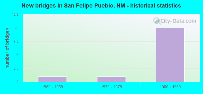
- New bridges - historical statistics
- 11960-1969
- 11970-1979
- 101980-1989
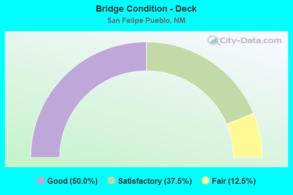
- Bridge Condition - Deck
- 50.0%Good
- 37.5%Satisfactory
- 12.5%Fair
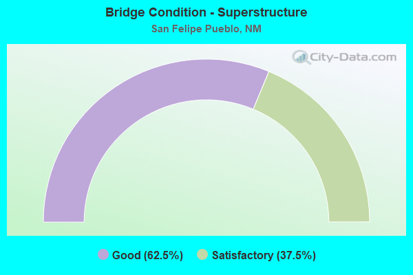
- Bridge Condition - Superstructure
- 62.5%Good
- 37.5%Satisfactory
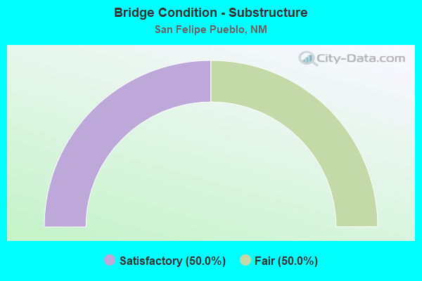
- Bridge Condition - Substructure
- 50.0%Satisfactory
- 50.0%Fair
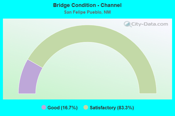
- Bridge Condition - Channel
- 16.7%Good
- 83.3%Satisfactory
Find on map >> Show street view
Structure Number: 8362, Location: 10.5 Mi N of Jct US-550 (Lat: 35.419247, Lng: -106.404072), Route carried "on" structure: Ramp Interstate 2252, Year Built: 1983, Status: Open, Structure Length: 12.22m (40.09ft), Average Daily Traffic: 968 (year 2020), Truck Traffic: 37%, Average Future Daily Traffic: 1,657 (year 2040), Design Load: HS 20, Features Intersected: Tonque Arroyo
Minimum Vertical Clearance: 30+ m (98+ ft), Kilometerpoint: 0.032, Lanes on structure: 1, Base Highway Network: Yes, Owner: State Highway Agency, Approaching Roadway Width: 8.3m (27.2ft), Skew: 4 degrees, Material/Design: Steel continuous, Design/Construction: Stringer/Multi-beam, Number Of Spans In Main Unit: 5, Length of Maximum Span: 26.5m (86.9ft), Curb-To-Curb Width: 8.5m (27.9ft), Out-to-Out Width: 9.4m (30.8ft)
Condition: Deck: Good, Superstructure: Good, Substructure: Fair, Channel: Satisfactory, Operating Rating: 50.2 metric tons, Method Used To Determine Operating Rating: Load Factor (LF), Inventory Rating: 32.4 metric tons, Method Used To Determine Inventory Rating: Load Factor (LF), Structural Evaluation: Somewhat better than minimum adequacy, Deck Geometry: Superior to present desirable criteria, Waterway Adequacy: Equal to present minimum criteria, Approach Roadway Alignment: Equal to present minimum criteria, Designated Inspection Frequency: Every 24 months, Inspection Date: Febuary 2022, Deck Structure Type: Concrete Cast-file-Place, Wearing Surface/Protective System: Deck Protection: Epoxy Coated Reinforcing
Find on map >> Show street view
Structure Number: 8373, Location: San Felipe Interchange (Lat: 35.417797, Lng: -106.405306), Route carried "on" structure: Interstate 25, Year Built: 1984, Status: Open, Structure Length: 4.79m (15.72ft), Average Daily Traffic: 30,964 (year 2020), Truck Traffic: 37%, Average Future Daily Traffic: 53,008 (year 2040), Design Load: HS 20, Features Intersected: San Felipe Pueblo X-Rd
Minimum Vertical Clearance: 30+ m (98+ ft), Kilometerpoint: 406.118, Lanes on structure: 2, Lanes under structure: 2, Base Highway Network: Yes, Owner: State Highway Agency, Approaching Roadway Width: 12.6m (41.3ft), Skew: 12 degrees, Material/Design: Prestressed concrete continuous, Design/Construction: Stringer/Multi-beam, Number Of Spans In Main Unit: 3, Length of Maximum Span: 23.2m (76.1ft), Curb-To-Curb Width: 12.8m (42.0ft), Out-to-Out Width: 13.2m (43.3ft)
Condition: Deck: Satisfactory, Superstructure: Good, Substructure: Satisfactory, Operating Rating: 46.5 metric tons, Method Used To Determine Operating Rating: Load Factor (LF), Inventory Rating: 29.0 metric tons, Method Used To Determine Inventory Rating: Load Factor (LF), Structural Evaluation: Equal to present minimum criteria, Deck Geometry: Equal to present desirable criteria, Underclear: Superior to present desirable criteria, Approach Roadway Alignment: Equal to present desirable criteria, Designated Inspection Frequency: Every 24 months, Inspection Date: Febuary 2022, Deck Structure Type: Concrete Cast-file-Place, Wearing Surface/Protective System: Deck Protection: Epoxy Coated Reinforcing
Find on map >> Show street view
Structure Number: 8374, Location: 10.5 M N Jct i-25/US-550 (Lat: 35.417647, Lng: -106.405033), Route carried "on" structure: Interstate 25, Year Built: 1984, Status: Open, Structure Length: 4.69m (15.39ft), Average Daily Traffic: 30,964 (year 2020), Truck Traffic: 37%, Average Future Daily Traffic: 53,008 (year 2040), Design Load: HS 20, Features Intersected: San Felipe Pueblo X-Rd
Minimum Vertical Clearance: 30+ m (98+ ft), Kilometerpoint: 406.118, Lanes on structure: 2, Lanes under structure: 2, Base Highway Network: Yes, Owner: State Highway Agency, Approaching Roadway Width: 12.6m (41.3ft), Skew: 12 degrees, Material/Design: Prestressed concrete continuous, Design/Construction: Stringer/Multi-beam, Number Of Spans In Main Unit: 3, Length of Maximum Span: 23.2m (76.1ft), Curb-To-Curb Width: 12.9m (42.3ft), Out-to-Out Width: 13.7m (44.9ft)
Condition: Deck: Good, Superstructure: Good, Substructure: Satisfactory, Operating Rating: 46.5 metric tons, Method Used To Determine Operating Rating: Load Factor (LF), Inventory Rating: 29.0 metric tons, Method Used To Determine Inventory Rating: Load Factor (LF), Structural Evaluation: Equal to present minimum criteria, Deck Geometry: Superior to present desirable criteria, Underclear: Superior to present desirable criteria, Approach Roadway Alignment: Equal to present desirable criteria, Designated Inspection Frequency: Every 24 months, Inspection Date: Febuary 2022, Deck Structure Type: Concrete Cast-file-Place, Wearing Surface/Protective System: Deck Protection: Epoxy Coated Reinforcing
Find on map >> Show street view
Structure Number: 8375, Location: 10.5 M N JCT US-550 (Lat: 35.418853, Lng: -106.403375), Route carried "on" structure: Interstate 25, Year Built: 1984, Status: Open, Structure Length: 10.39m (34.09ft), Average Daily Traffic: 30,964 (year 2020), Truck Traffic: 37%, Average Future Daily Traffic: 53,008 (year 2040), Design Load: HS 20, Features Intersected: Tonque Arroyo
Minimum Vertical Clearance: 30+ m (98+ ft), Kilometerpoint: 406.359, Lanes on structure: 2, Base Highway Network: Yes, Owner: State Highway Agency, Approaching Roadway Width: 12.5m (41.0ft), Skew: 12 degrees, Material/Design: Prestressed concrete continuous, Design/Construction: Stringer/Multi-beam, Number Of Spans In Main Unit: 4, Length of Maximum Span: 26.2m (86.0ft), Curb-To-Curb Width: 12.8m (42.0ft), Out-to-Out Width: 13.7m (44.9ft)
Condition: Deck: Satisfactory, Superstructure: Good, Substructure: Fair, Channel: Satisfactory, Operating Rating: 51.4 metric tons, Method Used To Determine Operating Rating: Load Factor (LF), Inventory Rating: 32.2 metric tons, Method Used To Determine Inventory Rating: Load Factor (LF), Structural Evaluation: Somewhat better than minimum adequacy, Deck Geometry: Equal to present desirable criteria, Waterway Adequacy: Equal to present minimum criteria, Approach Roadway Alignment: Equal to present desirable criteria, Designated Inspection Frequency: Every 24 months, Inspection Date: Febuary 2022, Deck Structure Type: Concrete Cast-file-Place, Wearing Surface/Protective System: Deck Protection: Epoxy Coated Reinforcing
Find on map >> Show street view
Structure Number: 8376, Location: 10.5 Mi N of Jct US-550 (Lat: 35.418728, Lng: -106.403061), Route carried "on" structure: Interstate 25, Year Built: 1984, Status: Open, Structure Length: 10.33m (33.89ft), Average Daily Traffic: 30,964 (year 2020), Truck Traffic: 37%, Average Future Daily Traffic: 53,008 (year 2040), Design Load: HS 20, Features Intersected: Tonque Arroyo
Minimum Vertical Clearance: 30+ m (98+ ft), Kilometerpoint: 406.359, Lanes on structure: 2, Base Highway Network: Yes, Owner: State Highway Agency, Approaching Roadway Width: 12.6m (41.3ft), Skew: 13 degrees, Material/Design: Prestressed concrete continuous, Design/Construction: Stringer/Multi-beam, Number Of Spans In Main Unit: 4, Length of Maximum Span: 26.2m (86.0ft), Curb-To-Curb Width: 12.8m (42.0ft), Out-to-Out Width: 13.7m (44.9ft)
Condition: Deck: Satisfactory, Superstructure: Satisfactory, Substructure: Fair, Channel: Satisfactory, Operating Rating: 51.4 metric tons, Method Used To Determine Operating Rating: Load Factor (LF), Inventory Rating: 32.2 metric tons, Method Used To Determine Inventory Rating: Load Factor (LF), Structural Evaluation: Somewhat better than minimum adequacy, Deck Geometry: Equal to present desirable criteria, Waterway Adequacy: Equal to present minimum criteria, Approach Roadway Alignment: Equal to present desirable criteria, Designated Inspection Frequency: Every 24 months, Inspection Date: Febuary 2022, Deck Structure Type: Concrete Cast-file-Place, Wearing Surface/Protective System: Deck Protection: Epoxy Coated Reinforcing
Find on map >> Show street view
Structure Number: 8422, Location: 12.3 Mi N Jct I-25/US-550 (Lat: 35.434678, Lng: -106.378261), Route carried "on" structure: Interstate 25, Year Built: 1983, Status: Open, Structure Length: 4.15m (13.62ft), Average Daily Traffic: 28,194 (year 2020), Truck Traffic: 37%, Average Future Daily Traffic: 48,265 (year 2040), Design Load: HS 20, Features Intersected: Arroyo De Los Tanos
Minimum Vertical Clearance: 30+ m (98+ ft), Kilometerpoint: 409.578, Lanes on structure: 2, Base Highway Network: Yes, Owner: State Highway Agency, Approaching Roadway Width: 12.5m (41.0ft), Skew: 12 degrees, Material/Design: Prestressed concrete continuous, Design/Construction: Stringer/Multi-beam, Number Of Spans In Main Unit: 2, Length of Maximum Span: 19.8m (65.0ft), Curb-To-Curb Width: 13.0m (42.7ft), Out-to-Out Width: 13.7m (44.9ft)
Condition: Deck: Good, Superstructure: Satisfactory, Substructure: Satisfactory, Channel: Good, Operating Rating: 53.5 metric tons, Method Used To Determine Operating Rating: Load Factor (LF), Inventory Rating: 32.4 metric tons, Method Used To Determine Inventory Rating: Load Factor (LF), Structural Evaluation: Equal to present minimum criteria, Deck Geometry: Superior to present desirable criteria, Waterway Adequacy: Equal to present minimum criteria, Approach Roadway Alignment: Better than present minimum criteria, Designated Inspection Frequency: Every 24 months, Inspection Date: October 2020, Deck Structure Type: Concrete Cast-file-Place, Wearing Surface/Protective System: Wearing Surface: Epoxy Overlay, Deck Protection: Epoxy Coated Reinforcing
Find on map >> Show street view
Structure Number: 8438, Location: SanFelipe gradeseparation (Lat: 35.401208, Lng: -106.435639), Route carried "on" structure: State highway 2084, Year Built: 1984, Status: Open, Structure Length: 9.33m (30.61ft), Average Daily Traffic: 152 (year 2020), Truck Traffic: 15%, Average Future Daily Traffic: 284 (year 2040), Design Load: HS 20, Features Intersected: I-25 NBL and SBL
Minimum Vertical Clearance: 30+ m (98+ ft), Kilometerpoint: 0.241, Lanes on structure: 2, Lanes under structure: 4, Owner: State Highway Agency, Approaching Roadway Width: 11.9m (39.0ft), Skew: 3 degrees, Material/Design: Steel continuous, Design/Construction: Stringer/Multi-beam, Number Of Spans In Main Unit: 3, Length of Maximum Span: 61.0m (200.1ft), Curb-To-Curb Width: 12.0m (39.4ft), Out-to-Out Width: 13.1m (43.0ft)
Condition: Deck: Good, Superstructure: Good, Substructure: Satisfactory, Operating Rating: 53.5 metric tons, Method Used To Determine Operating Rating: Load Factor (LF), Inventory Rating: 32.4 metric tons, Method Used To Determine Inventory Rating: Load Factor (LF), Structural Evaluation: Equal to present minimum criteria, Deck Geometry: Superior to present desirable criteria, Underclear: Better than present minimum criteria, Approach Roadway Alignment: Equal to present minimum criteria, Designated Inspection Frequency: Every 24 months, Inspection Date: January 2021, Deck Structure Type: Concrete Cast-file-Place, Wearing Surface/Protective System: Deck Protection: Epoxy Coated Reinforcing
Find on map >> Show street view
Structure Number: M101, Location: IN SAN FELIPE PUEBL0 (Lat: 35.440053, Lng: -106.442750), Route carried "on" structure: Federal lands road 85, Year Built: 1972, Status: Open, Structure Length: 12.25m (40.19ft), Average Daily Traffic: 1,500 (year 2021), Truck Traffic: 5%, Average Future Daily Traffic: 2,000 (year 2041), Features Intersected: RIO GRANDE RIVER
Minimum Vertical Clearance: 30+ m (98+ ft), Kilometerpoint: 11.400, Lanes on structure: 2, Owner: Bureau of Indian Affairs, Approaching Roadway Width: 7.0m (23.0ft), Skew: 2 degrees, Material/Design: Prestressed concrete, Design/Construction: Stringer/Multi-beam, Number Of Spans In Main Unit: 5, Length of Maximum Span: 24.5m (80.4ft), Curb or Sidewalk Widths: Left: 1.2m (3.9ft), Right: 0.0m, Curb-To-Curb Width: 9.4m (30.8ft), Out-to-Out Width: 11.1m (36.4ft)
Condition: Deck: Fair, Superstructure: Satisfactory, Substructure: Fair, Channel: Satisfactory, Operating Rating: 44.0 metric tons, Method Used To Determine Operating Rating: Load Factor (LF), Inventory Rating: 32.6 metric tons, Method Used To Determine Inventory Rating: Load Factor (LF), Structural Evaluation: Somewhat better than minimum adequacy, Deck Geometry: Somewhat better than minimum adequacy, Waterway Adequacy: Equal to present minimum criteria, Approach Roadway Alignment: Meets minimum limits, Length Of Structure Improvement: 15.00m (49.21ft), Designated Inspection Frequency: Every 24 months, Underwater Inspection Frequency: Every 60 months, Inspection Date: April 2021, Underwater Inspection Date: June 2019, Total Project Cost: $519,000 ( Estimate for 2021), Deck Structure Type: Concrete Cast-file-Place, Wearing Surface/Protective System: Wearing Surface: Monolithic Concrete
Find on map >> Show street view
Structure Number: 10084, Location: 7.94 MI N Jct I-25/US-550 (Lat: 35.399767, Lng: -106.438550), Route carried "on" structure: Interstate 25, Year Built: 1960, Year Reconstructed: 1983, Status: Open, Structure Length: 1.49m (4.89ft), Average Daily Traffic: 26,720 (year 2020), Truck Traffic: 37%, Average Future Daily Traffic: 45,742 (year 2040), Design Load: HS 20, Features Intersected: UNNAMED WATERWAY
Minimum Vertical Clearance: 30+ m (98+ ft), Kilometerpoint: 402.658, Lanes on structure: 6, Base Highway Network: Yes, Owner: State Highway Agency, Approaching Roadway Width: 42.1m (138.1ft), Skew: 10 degrees, Material/Design: Steel, Design/Construction: Culvert, Number Of Spans In Main Unit: 3, Length of Maximum Span: 4.0m (13.1ft)
Condition: Channel: Satisfactory, Culverts: Fair, Operating Rating: 53.5 metric tons, Method Used To Determine Operating Rating: Load Factor (LF), Inventory Rating: 32.4 metric tons, Method Used To Determine Inventory Rating: Load Factor (LF), Structural Evaluation: Somewhat better than minimum adequacy, Waterway Adequacy: Superior to present desirable criteria, Approach Roadway Alignment: Equal to present desirable criteria, Designated Inspection Frequency: Every 24 months, Inspection Date: March 2021
Find on map >> Show street view
Structure Number: 8373, Location: San Felipe Interchange (Lat: 35.417797, Lng: -106.405306), Route carried "under" structure: State highway 2085, Year Built: 1984, Structure Length: 0. m, Average Daily Traffic: 3,067 (year 2020), Truck Traffic: 16%, Features Intersected: San Felipe Pueblo X-Rd, Facility Carried by Structure: I-25 SBL
Minimum Vertical Clearance: 5.58m (18.31ft), Kilometerpoint: 0.306, Lanes on structure: 2, Lanes under structure: 2, Material/Design: Prestressed concrete continuous, Design/Construction: Stringer/Multi-beam, Length of Maximum Span: 23.2m (76.1ft)
Find on map >> Show street view
Structure Number: 8374, Location: 10.5 M N Jct i-25/US-550 (Lat: 35.417647, Lng: -106.405033), Route carried "under" structure: State highway 2085, Year Built: 1984, Structure Length: 0. m, Average Daily Traffic: 3,067 (year 2020), Truck Traffic: 16%, Features Intersected: San Felipe Pueblo X-Rd, Facility Carried by Structure: I-25 NBL
Minimum Vertical Clearance: 5.06m (16.60ft), Kilometerpoint: 0.322, Lanes on structure: 2, Lanes under structure: 2, Material/Design: Prestressed concrete continuous, Design/Construction: Stringer/Multi-beam, Length of Maximum Span: 23.2m (76.1ft)
Find on map >> Show street view
Structure Number: 8438, Location: SanFelipe gradeseparation (Lat: 35.401208, Lng: -106.435639), Route carried "under" structure: Interstate 25, Year Built: 1984, Structure Length: 0. m, Average Daily Traffic: 26,720 (year 2020), Truck Traffic: 37%, Features Intersected: I-25 NBL and SBL, Facility Carried by Structure: FR-2084
Minimum Vertical Clearance: 5.58m (18.31ft), Kilometerpoint: 402.449, Lanes on structure: 2, Lanes under structure: 4, Material/Design: Steel continuous, Design/Construction: Stringer/Multi-beam, Length of Maximum Span: 61.0m (200.1ft)