Bridge Statistics for San Mateo, California (CA)
Condition, Traffic, Stress, Structural Evaluation, Project Costs
- National Bridge Inventory (NBI) Statistics
- 95Number of bridges
- 1,906ft / 581mTotal length
- $1,352,000Total costs
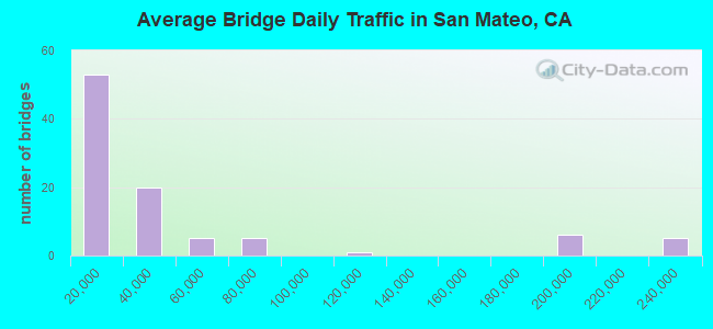
- 4,004,757Total average daily traffic
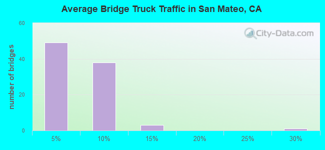
- 165,253Total average daily truck traffic
- National Bridge Inventory (NBI) Registered Bridges for San Mateo
- No street view available for this location
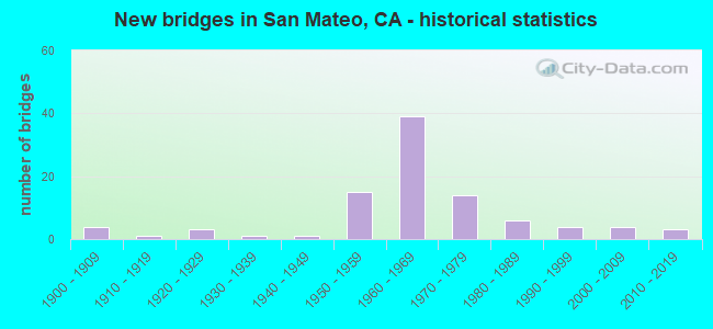
- New bridges - historical statistics
- 41900-1909
- 11910-1919
- 31920-1929
- 11930-1939
- 11940-1949
- 151950-1959
- 391960-1969
- 141970-1979
- 61980-1989
- 41990-1999
- 42000-2009
- 32010-2019
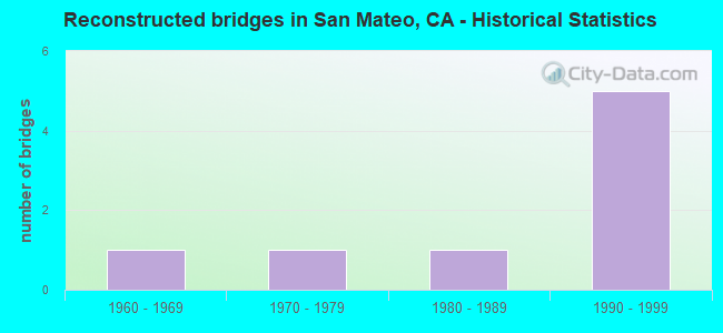
- Reconstructed bridges - Historical Statistics
- 11960-1969
- 11970-1979
- 11980-1989
- 51990-1999
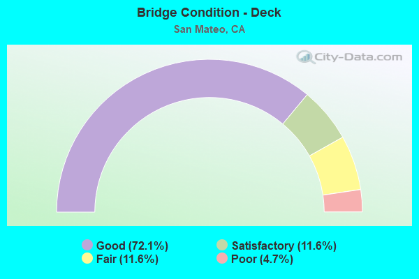
- Bridge Condition - Deck
- 72.1%Good
- 11.6%Satisfactory
- 11.6%Fair
- 4.7%Poor
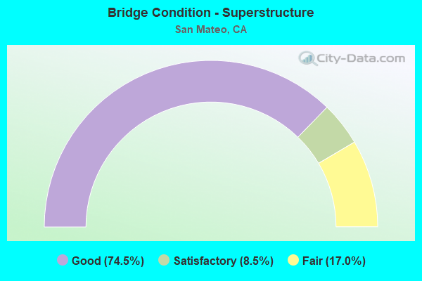
- Bridge Condition - Superstructure
- 74.5%Good
- 8.5%Satisfactory
- 17.0%Fair
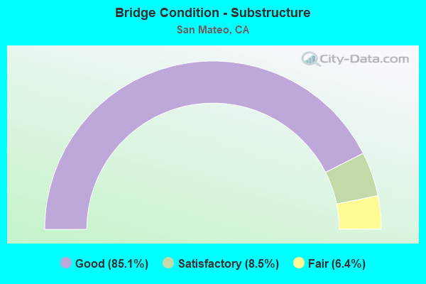
- Bridge Condition - Substructure
- 85.1%Good
- 8.5%Satisfactory
- 6.4%Fair

- Bridge Condition - Channel
- 25.8%Excellent
- 12.9%Very good
- 19.4%Good
- 38.7%Satisfactory
- 3.2%Poor
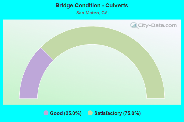
- Bridge Condition - Culverts
- 25.0%Good
- 75.0%Satisfactory
Find on map >> Show street view
Structure Number: 35 0010S, Location: 04-SM-101-13.44-SM (Lat: 37.571156, Lng: -122.312767), Route carried "on" structure: Ramp State highway 101, Year Built: 2004, Status: Open, Structure Length: 2.08m (6.82ft), Average Daily Traffic: 15,000 (year 2005), Truck Traffic: 2%, Average Future Daily Traffic: 31,746 (year 2037), Design Load: HS 20, Features Intersected: SAN MATEO CREEK
Minimum Vertical Clearance: 30+ m (98+ ft), Kilometerpoint: 13.440, Lanes on structure: 1, Base Highway Network: Yes (Inventory Route: 1, Subroute: 1), Owner: State Highway Agency, Approaching Roadway Width: 10.0m (32.8ft), Skew: 1 degrees, Material/Design: Concrete continuous, Design/Construction: Slab, Number Of Spans In Main Unit: 3, Length of Maximum Span: 8.6m (28.2ft), Curb-To-Curb Width: 9.1m (29.9ft), Out-to-Out Width: 10.0m (32.8ft)
Condition: Deck: Good, Superstructure: Good, Substructure: Good, Channel: Excellent, Operating Rating: 54.1 metric tons, Method Used To Determine Operating Rating: Assigned rating based on Load Factor Design (LFD) reported in metric tons, Inventory Rating: 32.4 metric tons, Method Used To Determine Inventory Rating: Assigned rating based on Load Factor Design (LFD) reported in metric tons, Structural Evaluation: Better than present minimum criteria, Deck Geometry: Superior to present desirable criteria, Waterway Adequacy: Equal to present desirable criteria, Approach Roadway Alignment: Equal to present desirable criteria, Designated Inspection Frequency: Every 48 months, Inspection Date: August 2019, Deck Structure Type: Concrete Cast-file-Place, Wearing Surface/Protective System: Wearing Surface: Bituminous
Find on map >> Show street view
Structure Number: 35 0010T, Location: 04-SM-101-13.44-SM (Lat: 37.571231, Lng: -122.312644), Route carried "on" structure: Ramp State highway 101, Year Built: 2004, Status: Open, Structure Length: 2.24m (7.35ft), Average Daily Traffic: 20,000 (year 2005), Truck Traffic: 5%, Average Future Daily Traffic: 31,746 (year 2037), Design Load: HS 20, Features Intersected: SAN MATEO CREEK
Minimum Vertical Clearance: 30+ m (98+ ft), Kilometerpoint: 13.440, Lanes on structure: 1, Base Highway Network: Yes (Inventory Route: 1, Subroute: 1), Owner: State Highway Agency, Approaching Roadway Width: 10.8m (35.4ft), Skew: 3 degrees, Material/Design: Concrete, Design/Construction: Slab, Number Of Spans In Main Unit: 3, Length of Maximum Span: 8.6m (28.2ft), Curb-To-Curb Width: 7.2m (23.6ft), Out-to-Out Width: 10.8m (35.4ft)
Condition: Deck: Good, Superstructure: Good, Substructure: Good, Channel: Excellent, Operating Rating: 54.1 metric tons, Method Used To Determine Operating Rating: Assigned rating based on Load Factor Design (LFD) reported in metric tons, Inventory Rating: 32.4 metric tons, Method Used To Determine Inventory Rating: Assigned rating based on Load Factor Design (LFD) reported in metric tons, Structural Evaluation: Better than present minimum criteria, Deck Geometry: Equal to present minimum criteria, Waterway Adequacy: Equal to present desirable criteria, Approach Roadway Alignment: Equal to present desirable criteria, Designated Inspection Frequency: Every 48 months, Inspection Date: August 2019, Deck Structure Type: Concrete Cast-file-Place
Find on map >> Show street view
Structure Number: 35 0021L, Location: 04-SM-001-R43.74-PFA (Lat: 37.629714, Lng: -122.489481), Route carried "on" structure: State highway 1, Year Built: 1965, Status: Open, Structure Length: 3.81m (12.50ft), Average Daily Traffic: 16,250 (year 2009), Truck Traffic: 3%, Average Future Daily Traffic: 24,514 (year 2035), Design Load: HS 20, Features Intersected: CLARENDON ROAD
Minimum Vertical Clearance: 30+ m (98+ ft), Kilometerpoint: 43.740, Lanes on structure: 2, Lanes under structure: 2, Base Highway Network: Yes (, Subroute: 1), Owner: State Highway Agency, Approaching Roadway Width: 11.3m (37.1ft), Material/Design: Concrete continuous, Design/Construction: Tee Beam, Number Of Spans In Main Unit: 3, Length of Maximum Span: 19.2m (63.0ft), Curb-To-Curb Width: 11.3m (37.1ft), Out-to-Out Width: 12.1m (39.7ft)
Condition: Deck: Satisfactory, Superstructure: Good, Substructure: Good, Operating Rating: 80.7 metric tons, Method Used To Determine Operating Rating: Load Factor (LF), Inventory Rating: 48.6 metric tons, Method Used To Determine Inventory Rating: Load Factor (LF), Structural Evaluation: Better than present minimum criteria, Deck Geometry: Somewhat better than minimum adequacy, Underclear: Meets minimum limits, Approach Roadway Alignment: Equal to present desirable criteria, Designated Inspection Frequency: Every 48 months, Inspection Date: October 2018, Deck Structure Type: Concrete Cast-file-Place, Wearing Surface/Protective System: Wearing Surface: Integral Concrete
Find on map >> Show street view
Structure Number: 35 0026, Location: 04-SM-101-13.46-SM (Lat: 37.570425, Lng: -122.314239), Route carried "on" structure: City street D444, Year Built: 1953, Year Reconstructed: 1996, Status: Open, Structure Length: 9.45m (31.00ft), Average Daily Traffic: 4,590 (year 1998), Truck Traffic: 7%, Average Future Daily Traffic: 15,015 (year 2041), Design Load: HS 20, Features Intersected: US HIGHWAY 101, Facility Carried by Structure: THIRD AVENUE
Minimum Vertical Clearance: 30+ m (98+ ft), Kilometerpoint: 0.000, Lanes on structure: 6, Lanes under structure: 11, Base Highway Network: Yes, Owner: State Highway Agency, Approaching Roadway Width: 25.4m (83.3ft), Skew: 31 degrees, Material/Design: Concrete continuous, Design/Construction: Tee Beam, Number Of Spans In Main Unit: 6, Length of Maximum Span: 20.4m (66.9ft), Curb or Sidewalk Widths: Left: 1.5m (4.9ft), Right: 1.5m (4.9ft), Curb-To-Curb Width: 25.4m (83.3ft), Out-to-Out Width: 31.4m (103.0ft)
Condition: Deck: Good, Superstructure: Good, Substructure: Good, Operating Rating: 38.9 metric tons, Method Used To Determine Operating Rating: Load and Resistance Factor Rating (LRFR) rating reported by rating factor(RF) method using HL-93 loadings, Inventory Rating: 25.9 metric tons, Method Used To Determine Inventory Rating: Load and Resistance Factor Rating (LRFR) rating reported by rating factor(RF) method using HL-93 loadings, Structural Evaluation: Equal to present minimum criteria, Deck Geometry: Somewhat better than minimum adequacy, Underclear: High priority of corrective action, Approach Roadway Alignment: Equal to present desirable criteria, Designated Inspection Frequency: Every 24 months, Inspection Date: August 2021, Deck Structure Type: Concrete Cast-file-Place
Find on map >> Show street view
Structure Number: 35 0027, Location: 04-SM-101-11.90-SM (Lat: 37.553089, Lng: -122.296436), Route carried "on" structure: City street D302, Year Built: 1985, Status: Open, Structure Length: 9.08m (29.79ft), Average Daily Traffic: 4,070 (year 1998), Truck Traffic: 2%, Average Future Daily Traffic: 8,876 (year 2041), Design Load: HS 20+Mod, Features Intersected: US HIGHWAY 101, Facility Carried by Structure: FASHION ISLAND BL
Minimum Vertical Clearance: 30+ m (98+ ft), Kilometerpoint: 0.000, Lanes on structure: 2, Lanes under structure: 10, Owner: State Highway Agency, Approaching Roadway Width: 12.2m (40.0ft), Skew: 2 degrees, Material/Design: Prestressed concrete continuous, Design/Construction: Box Beam or Girders - Multiple, Number Of Spans In Main Unit: 2, Length of Maximum Span: 45.4m (149.0ft), Curb or Sidewalk Widths: Left: 0.0m, Right: 1.5m (4.9ft), Curb-To-Curb Width: 12.2m (40.0ft), Out-to-Out Width: 13.9m (45.6ft)
Condition: Deck: Good, Superstructure: Good, Substructure: Good, Operating Rating: 54.1 metric tons, Method Used To Determine Operating Rating: Assigned rating based on Load Factor Design (LFD) reported in metric tons, Inventory Rating: 32.4 metric tons, Method Used To Determine Inventory Rating: Assigned rating based on Load Factor Design (LFD) reported in metric tons, Structural Evaluation: Better than present minimum criteria, Deck Geometry: Equal to present minimum criteria, Underclear: Somewhat better than minimum adequacy, Approach Roadway Alignment: Equal to present desirable criteria, Designated Inspection Frequency: Every 24 months, Inspection Date: August 2021, Deck Structure Type: Concrete Cast-file-Place
Find on map >> Show street view
Structure Number: 35 004, Location: 04-SM-280-R12.32 (Lat: 37.523061, Lng: -122.356419), Route carried "on" structure: County highway , Year Built: 1969, Status: Open, Structure Length: 7.93m (26.02ft), Average Daily Traffic: 3,300 (year 1998), Truck Traffic: 2%, Average Future Daily Traffic: 4,168 (year 2038), Design Load: HS 20+Mod, Features Intersected: INTERSTATE 280, Facility Carried by Structure: BUNKER HILL DRIVE
Minimum Vertical Clearance: 30+ m (98+ ft), Kilometerpoint: 0.000, Lanes on structure: 2, Lanes under structure: 8, Owner: State Highway Agency, Approaching Roadway Width: 12.2m (40.0ft), Skew: 2 degrees, Material/Design: Prestressed concrete continuous, Design/Construction: Box Beam or Girders - Multiple, Number Of Spans In Main Unit: 2, Length of Maximum Span: 39.6m (129.9ft), Curb-To-Curb Width: 12.2m (40.0ft), Out-to-Out Width: 13.3m (43.6ft)
Condition: Deck: Satisfactory, Superstructure: Good, Substructure: Good, Operating Rating: 89.7 metric tons, Method Used To Determine Operating Rating: Load Factor (LF), Inventory Rating: 32.4 metric tons, Method Used To Determine Inventory Rating: Load Factor (LF), Structural Evaluation: Better than present minimum criteria, Deck Geometry: Equal to present minimum criteria, Underclear: Equal to present minimum criteria, Approach Roadway Alignment: Equal to present desirable criteria, Designated Inspection Frequency: Every 24 months, Inspection Date: July 2021, Deck Structure Type: Concrete Cast-file-Place
Find on map >> Show street view
Structure Number: 35 0047, Location: 04-SM-082-11.82-SM (Lat: 37.564136, Lng: -122.326950), Route carried "on" structure: State highway 82, Year Built: 1935, Status: Open, Structure Length: 1.34m (4.40ft), Average Daily Traffic: 30,250 (year 2009), Average Future Daily Traffic: 39,612 (year 2037), Features Intersected: SAN MATEO CREEK
Minimum Vertical Clearance: 30+ m (98+ ft), Kilometerpoint: 11.820, Lanes on structure: 4, Base Highway Network: Yes (, Subroute: 1), Owner: State Highway Agency, Approaching Roadway Width: 21.9m (71.9ft), Material/Design: Concrete, Design/Construction: Arch - Deck, Number Of Spans In Main Unit: 1, Length of Maximum Span: 12.2m (40.0ft), Curb or Sidewalk Widths: Left: 1.8m (5.9ft), Right: 3.6m (11.8ft), Curb-To-Curb Width: 23.2m (76.1ft), Out-to-Out Width: 29.0m (95.1ft)
Condition: Superstructure: Satisfactory, Substructure: Good, Channel: Good, Operating Rating: 40.5 metric tons, Method Used To Determine Operating Rating: Field evaluation and documented engineering judgment, Inventory Rating: 24.3 metric tons, Method Used To Determine Inventory Rating: Field evaluation and documented engineering judgment, Structural Evaluation: Equal to present minimum criteria, Deck Geometry: Superior to present desirable criteria, Waterway Adequacy: Equal to present desirable criteria, Approach Roadway Alignment: Equal to present minimum criteria, Designated Inspection Frequency: Every 24 months, Inspection Date: May 2020
Find on map >> Show street view
Structure Number: 35 0104, Location: 04-SM-082-7.36-SM (Lat: 37.517156, Lng: -122.271947), Route carried "on" structure: State highway 82, Year Built: 1941, Year Reconstructed: 1995, Status: Open, Structure Length: 1.07m (3.51ft), Average Daily Traffic: 34,750 (year 2009), Average Future Daily Traffic: 54,444 (year 2038), Features Intersected: BELMONT CREEK
Minimum Vertical Clearance: 30+ m (98+ ft), Kilometerpoint: 7.360, Lanes on structure: 4, Base Highway Network: Yes (, Subroute: 1), Owner: State Highway Agency, Approaching Roadway Width: 13.7m (44.9ft), Skew: 5 degrees, Material/Design: Concrete continuous, Design/Construction: Culvert, Number Of Spans In Main Unit: 2, Length of Maximum Span: 6.1m (20.0ft)
Condition: Channel: Good, Culverts: Satisfactory, Operating Rating: 27.2 metric tons, Method Used To Determine Operating Rating: Field evaluation and documented engineering judgment, Inventory Rating: 16.2 metric tons, Method Used To Determine Inventory Rating: Field evaluation and documented engineering judgment, Structural Evaluation: Meets minimum limits, Waterway Adequacy: Equal to present minimum criteria, Approach Roadway Alignment: Equal to present desirable criteria, Designated Inspection Frequency: Every 24 months, Inspection Date: May 2020
Find on map >> Show street view
Structure Number: 35 0105, Location: 04-SM-082-9.24-SM (Lat: 37.536000, Lng: -122.296106), Route carried "on" structure: State highway 82, Year Built: 1965, Status: Open, Structure Length: 0.84m (2.76ft), Average Daily Traffic: 34,750 (year 2009), Average Future Daily Traffic: 54,444 (year 2038), Features Intersected: LAUREL CREEK
Minimum Vertical Clearance: 30+ m (98+ ft), Kilometerpoint: 9.240, Lanes on structure: 9, Base Highway Network: Yes (, Subroute: 1), Owner: State Highway Agency, Approaching Roadway Width: 29.6m (97.1ft), Skew: 22 degrees, Material/Design: Concrete continuous, Design/Construction: Culvert, Number Of Spans In Main Unit: 2, Length of Maximum Span: 3.7m (12.1ft), Curb or Sidewalk Widths: Left: 2.1m (6.9ft), Right: 0.0m, Curb-To-Curb Width: 29.6m (97.1ft), Out-to-Out Width: 50.7m (166.3ft)
Condition: Channel: Good, Culverts: Satisfactory, Operating Rating: 54.1 metric tons, Method Used To Determine Operating Rating: Field evaluation and documented engineering judgment, Inventory Rating: 32.4 metric tons, Method Used To Determine Inventory Rating: Field evaluation and documented engineering judgment, Structural Evaluation: Equal to present minimum criteria, Deck Geometry: High priority of replacement, Waterway Adequacy: Equal to present minimum criteria, Approach Roadway Alignment: Equal to present desirable criteria, Designated Inspection Frequency: Every 48 months, Inspection Date: May 2020
Find on map >> Show street view
Structure Number: 35 013, Location: 04-SM-101-23.66-BSBN (Lat: 37.672992, Lng: -122.390069), Route carried "on" structure: US 101, Year Built: 1956, Year Reconstructed: 1969, Status: Open, Structure Length: 18.78m (61.61ft), Average Daily Traffic: 196,000 (year 2009), Truck Traffic: 4%, Average Future Daily Traffic: 243,117 (year 2039), Design Load: HS 20, Features Intersected: CALTRAIN,UP RR,SIERRA PT
Minimum Vertical Clearance: 30+ m (98+ ft), Kilometerpoint: 23.660, Lanes on structure: 8, Lanes under structure: 2, Base Highway Network: Yes (Inventory Route: 1, Subroute: 1), Owner: State Highway Agency, Approaching Roadway Width: 38.4m (126.0ft), Skew: 39 degrees, Material/Design: Steel, Design/Construction: Stringer/Multi-beam, Number Of Spans In Main Unit: 8, Length of Maximum Span: 31.7m (104.0ft), Curb or Sidewalk Widths: Left: 0.3m (1.0ft), Right: 0.3m (1.0ft), Curb-To-Curb Width: 33.6m (110.2ft), Out-to-Out Width: 35.4m (116.1ft)
Condition: Deck: Fair, Superstructure: Good, Substructure: Good, Operating Rating: 49.2 metric tons, Method Used To Determine Operating Rating: Load and Resistance Factor Rating (LRFR) rating reported by rating factor(RF) method using HL-93 loadings, Inventory Rating: 37.9 metric tons, Method Used To Determine Inventory Rating: Load and Resistance Factor Rating (LRFR) rating reported by rating factor(RF) method using HL-93 loadings, Structural Evaluation: Better than present minimum criteria, Deck Geometry: Meets minimum limits, Underclear: High priority of corrective action, Approach Roadway Alignment: Equal to present desirable criteria, Designated Inspection Frequency: Every 24 months, Critical Feature Inspection Frequency: Every 24 months, Inspection Date: April 2021, Critical Feature Inspection Date: August 2020, Deck Structure Type: Concrete Cast-file-Place
Find on map >> Show street view
Structure Number: 35 0132K, Location: 04-SM-101-13.45-SM (Lat: 37.569897, Lng: -122.314403), Route carried "on" structure: Ramp US 101, Year Built: 1996, Status: Open, Structure Length: 1.75m (5.74ft), Average Daily Traffic: 14,400 (year 2015), Truck Traffic: 7%, Average Future Daily Traffic: 22,002 (year 2041), Design Load: HS 20+Mod, Features Intersected: SAN MATEO CREEK
Minimum Vertical Clearance: 30+ m (98+ ft), Kilometerpoint: 13.450, Lanes on structure: 1, Base Highway Network: Yes (Inventory Route: 1, Subroute: 1), Owner: State Highway Agency, Approaching Roadway Width: 7.9m (25.9ft), Skew: 9 degrees, Material/Design: Concrete continuous, Design/Construction: Slab, Number Of Spans In Main Unit: 3, Length of Maximum Span: 8.5m (27.9ft), Curb-To-Curb Width: 7.9m (25.9ft), Out-to-Out Width: 9.0m (29.5ft)
Condition: Deck: Good, Superstructure: Good, Substructure: Good, Channel: Very good, Operating Rating: 54.1 metric tons, Method Used To Determine Operating Rating: Assigned rating based on Load Factor Design (LFD) reported in metric tons, Inventory Rating: 32.4 metric tons, Method Used To Determine Inventory Rating: Assigned rating based on Load Factor Design (LFD) reported in metric tons, Structural Evaluation: Better than present minimum criteria, Deck Geometry: Equal to present desirable criteria, Waterway Adequacy: Equal to present desirable criteria, Approach Roadway Alignment: Equal to present minimum criteria, Designated Inspection Frequency: Every 48 months, Inspection Date: August 2019, Deck Structure Type: Concrete Cast-file-Place
Find on map >> Show street view
Structure Number: 35 0138, Location: 04-SM-101-11.15-SM (Lat: 37.544231, Lng: -122.288256), Route carried "on" structure: City street D394, Year Built: 1954, Year Reconstructed: 1976, Status: Open, Structure Length: 8.69m (28.51ft), Average Daily Traffic: 18,300 (year 1998), Truck Traffic: 2%, Average Future Daily Traffic: 40,235 (year 2041), Design Load: HS 20, Features Intersected: US HIGHWAY 101, Facility Carried by Structure: EAST HILLSDALE BL
Minimum Vertical Clearance: 30+ m (98+ ft), Kilometerpoint: 0.000, Lanes on structure: 2, Lanes under structure: 12, Owner: State Highway Agency, Approaching Roadway Width: 25.0m (82.0ft), Skew: 20 degrees, Material/Design: Steel continuous, Design/Construction: Stringer/Multi-beam, Number Of Spans In Main Unit: 4, Length of Maximum Span: 21.3m (69.9ft), Curb or Sidewalk Widths: Left: 1.5m (4.9ft), Right: 1.5m (4.9ft), Curb-To-Curb Width: 24.3m (79.7ft), Out-to-Out Width: 29.3m (96.1ft)
Condition: Deck: Good, Superstructure: Fair, Substructure: Good, Operating Rating: 38.2 metric tons, Method Used To Determine Operating Rating: Load and Resistance Factor Rating (LRFR) rating reported by rating factor(RF) method using HL-93 loadings, Inventory Rating: 26.2 metric tons, Method Used To Determine Inventory Rating: Load and Resistance Factor Rating (LRFR) rating reported by rating factor(RF) method using HL-93 loadings, Structural Evaluation: Somewhat better than minimum adequacy, Deck Geometry: Superior to present desirable criteria, Underclear: High priority of corrective action, Approach Roadway Alignment: Equal to present desirable criteria, Designated Inspection Frequency: Every 24 months, Other Special Inspection Frequency: Every 48 months, Inspection Date: August 2021, Other Special Inspection Date: March 2018, Deck Structure Type: Concrete Cast-file-Place
Find on map >> Show street view
Structure Number: 35 0141, Location: 04-SM-101-10.25-SM (Lat: 37.534153, Lng: -122.277967), Route carried "on" structure: US 101, Year Built: 1954, Year Reconstructed: 2002, Status: Open, Structure Length: 1.16m (3.81ft), Average Daily Traffic: 195,000 (year 2009), Truck Traffic: 5%, Average Future Daily Traffic: 257,837 (year 2041), Design Load: HS 20, Features Intersected: LAUREL CREEK
Minimum Vertical Clearance: 30+ m (98+ ft), Kilometerpoint: 10.250, Lanes on structure: 10, Base Highway Network: Yes (Inventory Route: 1, Subroute: 1), Owner: State Highway Agency, Approaching Roadway Width: 54.3m (178.1ft), Skew: 20 degrees, Material/Design: Concrete continuous, Design/Construction: Slab, Number Of Spans In Main Unit: 2, Length of Maximum Span: 5.5m (18.0ft), Curb-To-Curb Width: 42.4m (139.1ft), Out-to-Out Width: 50.7m (166.3ft)
Condition: Deck: Good, Superstructure: Good, Substructure: Good, Channel: Very good, Operating Rating: 82.9 metric tons, Method Used To Determine Operating Rating: Load Factor (LF), Inventory Rating: 49.9 metric tons, Method Used To Determine Inventory Rating: Load Factor (LF), Structural Evaluation: Better than present minimum criteria, Deck Geometry: Equal to present minimum criteria, Waterway Adequacy: Equal to present desirable criteria, Approach Roadway Alignment: Equal to present desirable criteria, Designated Inspection Frequency: Every 48 months, Inspection Date: August 2019, Deck Structure Type: Concrete Cast-file-Place, Wearing Surface/Protective System: Wearing Surface: Bituminous
Find on map >> Show street view
Structure Number: 35 0155, Location: 04-SM-101-0.89-EAPA (Lat: 37.460067, Lng: -122.140872), Route carried "on" structure: County highway D342, Year Built: 1958, Status: Open, Structure Length: 10.79m (35.40ft), Average Daily Traffic: 24,700 (year 2005), Truck Traffic: 3%, Average Future Daily Traffic: 52,976 (year 2041), Design Load: HS 20, Features Intersected: US HIGHWAY 101, Facility Carried by Structure: UNIVERSITY AVE SB
Minimum Vertical Clearance: 30+ m (98+ ft), Kilometerpoint: 0.000, Lanes on structure: 2, Lanes under structure: 12, Base Highway Network: Yes, Owner: State Highway Agency, Approaching Roadway Width: 8.5m (27.9ft), Skew: 5 degrees, Material/Design: Steel, Design/Construction: Stringer/Multi-beam, Number Of Spans In Main Unit: 4, Length of Maximum Span: 33.7m (110.6ft), Curb or Sidewalk Widths: Left: 1.6m (5.2ft), Right: 0.6m (2.0ft), Curb-To-Curb Width: 8.5m (27.9ft), Out-to-Out Width: 11.2m (36.7ft)
Condition: Deck: Satisfactory, Superstructure: Satisfactory, Substructure: Good, Operating Rating: 41.5 metric tons, Method Used To Determine Operating Rating: Load Factor (LF), Inventory Rating: 24.9 metric tons, Method Used To Determine Inventory Rating: Load Factor (LF), Structural Evaluation: Equal to present minimum criteria, Deck Geometry: High priority of corrective action, Underclear: High priority of corrective action, Approach Roadway Alignment: Equal to present desirable criteria, Designated Inspection Frequency: Every 24 months, Critical Feature Inspection Frequency: Every 24 months, Inspection Date: August 2021, Critical Feature Inspection Date: June 2020, Deck Structure Type: Concrete Cast-file-Place
Find on map >> Show street view
Structure Number: 35 0156L, Location: 04-SM-092-R11.19-SM (Lat: 37.550161, Lng: -122.312331), Route carried "on" structure: State highway 92, Year Built: 1963, Status: Open, Structure Length: 5.67m (18.60ft), Average Daily Traffic: 36,000 (year 2009), Truck Traffic: 3%, Average Future Daily Traffic: 69,962 (year 2040), Design Load: HS 20, Features Intersected: STATE ROUTE 82
Minimum Vertical Clearance: 30+ m (98+ ft), Kilometerpoint: 11.190, Lanes on structure: 3, Lanes under structure: 8, Base Highway Network: Yes (, Subroute: 1), Owner: State Highway Agency, Approaching Roadway Width: 12.2m (40.0ft), Material/Design: Concrete continuous, Design/Construction: Box Beam or Girders - Multiple, Number Of Spans In Main Unit: 4, Length of Maximum Span: 20.1m (65.9ft), Curb or Sidewalk Widths: Left: 0.6m (2.0ft), Right: 0.0m, Curb-To-Curb Width: 12.5m (41.0ft), Out-to-Out Width: 14.0m (45.9ft)
Condition: Deck: Good, Superstructure: Good, Substructure: Good, Operating Rating: 33.7 metric tons, Method Used To Determine Operating Rating: Load and Resistance Factor Rating (LRFR) rating reported by rating factor(RF) method using HL-93 loadings, Inventory Rating: 25.9 metric tons, Method Used To Determine Inventory Rating: Load and Resistance Factor Rating (LRFR) rating reported by rating factor(RF) method using HL-93 loadings, Structural Evaluation: Equal to present minimum criteria, Deck Geometry: High priority of replacement, Underclear: Equal to present minimum criteria, Approach Roadway Alignment: Equal to present desirable criteria, Designated Inspection Frequency: Every 24 months, Inspection Date: August 2020, Deck Structure Type: Concrete Cast-file-Place
Find on map >> Show street view
Structure Number: 35 0156R, Location: 04-SM-092-R11.19-SM (Lat: 37.550031, Lng: -122.312181), Route carried "on" structure: State highway 92, Year Built: 1963, Status: Open, Structure Length: 5.67m (18.60ft), Average Daily Traffic: 36,000 (year 2009), Truck Traffic: 3%, Average Future Daily Traffic: 70,429 (year 2042), Design Load: HS 20, Features Intersected: STATE ROUTE 82
Minimum Vertical Clearance: 30+ m (98+ ft), Kilometerpoint: 11.190, Lanes on structure: 3, Lanes under structure: 8, Base Highway Network: Yes (, Subroute: 1), Owner: State Highway Agency, Approaching Roadway Width: 12.2m (40.0ft), Material/Design: Concrete continuous, Design/Construction: Box Beam or Girders - Multiple, Number Of Spans In Main Unit: 4, Length of Maximum Span: 20.1m (65.9ft), Curb or Sidewalk Widths: Left: 0.0m, Right: 0.6m (2.0ft), Curb-To-Curb Width: 12.5m (41.0ft), Out-to-Out Width: 14.0m (45.9ft)
Condition: Deck: Good, Superstructure: Good, Substructure: Good, Operating Rating: 33.0 metric tons, Method Used To Determine Operating Rating: Load and Resistance Factor Rating (LRFR) rating reported by rating factor(RF) method using HL-93 loadings, Inventory Rating: 25.3 metric tons, Method Used To Determine Inventory Rating: Load and Resistance Factor Rating (LRFR) rating reported by rating factor(RF) method using HL-93 loadings, Structural Evaluation: Equal to present minimum criteria, Deck Geometry: High priority of replacement, Underclear: Equal to present minimum criteria, Approach Roadway Alignment: Equal to present desirable criteria, Designated Inspection Frequency: Every 24 months, Inspection Date: August 2020, Deck Structure Type: Concrete Cast-file-Place
Find on map >> Show street view
Structure Number: 35 0157L, Location: 04-SM-092-R11.38-SM (Lat: 37.551836, Lng: -122.309650), Route carried "on" structure: State highway 92, Year Built: 1963, Status: Open, Structure Length: 9.88m (32.41ft), Average Daily Traffic: 36,000 (year 2009), Truck Traffic: 3%, Average Future Daily Traffic: 70,429 (year 2042), Features Intersected: CALTRAIN,UP RR,PACIFIC,
Minimum Vertical Clearance: 30+ m (98+ ft), Kilometerpoint: 11.380, Lanes on structure: 2, Lanes under structure: 6, Base Highway Network: Yes (, Subroute: 1), Owner: State Highway Agency, Approaching Roadway Width: 11.6m (38.1ft), Skew: 9 degrees, Material/Design: Concrete continuous, Design/Construction: Box Beam or Girders - Multiple, Number Of Spans In Main Unit: 5, Length of Maximum Span: 26.8m (87.9ft), Curb or Sidewalk Widths: Left: 0.6m (2.0ft), Right: 0.0m, Curb-To-Curb Width: 11.6m (38.1ft), Out-to-Out Width: 14.0m (45.9ft)
Condition: Deck: Good, Superstructure: Good, Substructure: Good, Operating Rating: 38.2 metric tons, Method Used To Determine Operating Rating: Load and Resistance Factor Rating (LRFR) rating reported by rating factor(RF) method using HL-93 loadings, Inventory Rating: 27.9 metric tons, Method Used To Determine Inventory Rating: Load and Resistance Factor Rating (LRFR) rating reported by rating factor(RF) method using HL-93 loadings, Structural Evaluation: Better than present minimum criteria, Deck Geometry: Equal to present minimum criteria, Underclear: High priority of corrective action, Approach Roadway Alignment: Better than present minimum criteria, Designated Inspection Frequency: Every 24 months, Inspection Date: August 2020, Deck Structure Type: Concrete Cast-file-Place
Find on map >> Show street view
Structure Number: 35 0157R, Location: 04-SM-092-R11.38-SM (Lat: 37.551622, Lng: -122.309531), Route carried "on" structure: State highway 92, Year Built: 1963, Status: Open, Structure Length: 9.69m (31.79ft), Average Daily Traffic: 36,000 (year 2009), Truck Traffic: 3%, Average Future Daily Traffic: 69,962 (year 2040), Design Load: HS 20, Features Intersected: CALTRAIN,UP RR,PACIFIC,
Minimum Vertical Clearance: 30+ m (98+ ft), Kilometerpoint: 11.380, Lanes on structure: 3, Lanes under structure: 6, Base Highway Network: Yes (, Subroute: 1), Owner: State Highway Agency, Approaching Roadway Width: 11.0m (36.1ft), Skew: 9 degrees, Material/Design: Concrete continuous, Design/Construction: Box Beam or Girders - Multiple, Number Of Spans In Main Unit: 5, Length of Maximum Span: 26.5m (86.9ft), Curb or Sidewalk Widths: Left: 0.0m, Right: 1.8m (5.9ft), Curb-To-Curb Width: 11.9m (39.0ft), Out-to-Out Width: 15.1m (49.5ft)
Condition: Deck: Good, Superstructure: Good, Substructure: Good, Operating Rating: 65.1 metric tons, Method Used To Determine Operating Rating: Load Factor (LF), Inventory Rating: 38.9 metric tons, Method Used To Determine Inventory Rating: Load Factor (LF), Structural Evaluation: Better than present minimum criteria, Deck Geometry: High priority of replacement, Underclear: High priority of corrective action, Approach Roadway Alignment: Better than present minimum criteria, Designated Inspection Frequency: Every 48 months, Inspection Date: August 2020, Deck Structure Type: Concrete Cast-file-Place
Find on map >> Show street view
Structure Number: 35 0158L, Location: 04-SM-092-R11.61-SM (Lat: 37.552586, Lng: -122.305628), Route carried "on" structure: State highway 92, Year Built: 1963, Status: Open, Structure Length: 4.33m (14.21ft), Average Daily Traffic: 52,500 (year 2009), Truck Traffic: 5%, Average Future Daily Traffic: 85,781 (year 2036), Design Load: HS 20, Features Intersected: DELAWARE STREET
Minimum Vertical Clearance: 30+ m (98+ ft), Kilometerpoint: 11.610, Lanes on structure: 3, Lanes under structure: 5, Base Highway Network: Yes (, Subroute: 1), Owner: State Highway Agency, Approaching Roadway Width: 15.2m (49.9ft), Material/Design: Concrete continuous, Design/Construction: Box Beam or Girders - Multiple, Number Of Spans In Main Unit: 3, Length of Maximum Span: 25.0m (82.0ft), Curb or Sidewalk Widths: Left: 0.6m (2.0ft), Right: 0.0m, Curb-To-Curb Width: 15.2m (49.9ft), Out-to-Out Width: 16.7m (54.8ft)
Condition: Deck: Good, Superstructure: Good, Substructure: Good, Operating Rating: 99.8 metric tons, Method Used To Determine Operating Rating: Load Factor (LF), Inventory Rating: 60.3 metric tons, Method Used To Determine Inventory Rating: Load Factor (LF), Structural Evaluation: Better than present minimum criteria, Deck Geometry: Meets minimum limits, Underclear: Somewhat better than minimum adequacy, Approach Roadway Alignment: Equal to present desirable criteria, Designated Inspection Frequency: Every 48 months, Inspection Date: August 2018, Deck Structure Type: Concrete Cast-file-Place
Find on map >> Show street view
Structure Number: 35 0158R, Location: 04-SM-092-R11.61-SM (Lat: 37.552389, Lng: -122.305597), Route carried "on" structure: State highway 92, Year Built: 1963, Status: Open, Structure Length: 4.33m (14.21ft), Average Daily Traffic: 52,500 (year 2009), Truck Traffic: 5%, Average Future Daily Traffic: 86,931 (year 2040), Design Load: HS 20, Features Intersected: DELAWARE STREET
Minimum Vertical Clearance: 30+ m (98+ ft), Kilometerpoint: 11.610, Lanes on structure: 2, Lanes under structure: 5, Base Highway Network: Yes (, Subroute: 1), Owner: State Highway Agency, Approaching Roadway Width: 10.4m (34.1ft), Material/Design: Concrete continuous, Design/Construction: Box Beam or Girders - Multiple, Number Of Spans In Main Unit: 3, Length of Maximum Span: 25.0m (82.0ft), Curb-To-Curb Width: 11.3m (37.1ft), Out-to-Out Width: 12.3m (40.4ft)
Condition: Deck: Good, Superstructure: Fair, Substructure: Good, Operating Rating: 35.0 metric tons, Method Used To Determine Operating Rating: Load and Resistance Factor Rating (LRFR) rating reported by rating factor(RF) method using HL-93 loadings, Inventory Rating: 24.6 metric tons, Method Used To Determine Inventory Rating: Load and Resistance Factor Rating (LRFR) rating reported by rating factor(RF) method using HL-93 loadings, Structural Evaluation: Somewhat better than minimum adequacy, Deck Geometry: Somewhat better than minimum adequacy, Underclear: Somewhat better than minimum adequacy, Approach Roadway Alignment: Equal to present desirable criteria, Designated Inspection Frequency: Every 24 months, Inspection Date: August 2020, Deck Structure Type: Concrete Cast-file-Place
Find on map >> Show street view
Structure Number: 35 016, Location: 04-SM-092-R11.30-SM (Lat: 37.551039, Lng: -122.310533), Route carried "on" structure: State highway 92, Year Built: 1963, Status: Open, Structure Length: 1.92m (6.30ft), Average Daily Traffic: 72,000 (year 2009), Truck Traffic: 3%, Average Future Daily Traffic: 138,074 (year 2036), Design Load: HS 20, Features Intersected: PALM AVENUE
Minimum Vertical Clearance: 30+ m (98+ ft), Kilometerpoint: 11.300, Lanes on structure: 6, Lanes under structure: 2, Base Highway Network: Yes (, Subroute: 1), Owner: State Highway Agency, Approaching Roadway Width: 18.3m (60.0ft), Skew: 20 degrees, Material/Design: Concrete, Design/Construction: Box Beam or Girders - Multiple, Number Of Spans In Main Unit: 1, Length of Maximum Span: 19.2m (63.0ft)
Condition: Deck: Good, Superstructure: Good, Substructure: Good, Operating Rating: 92.0 metric tons, Method Used To Determine Operating Rating: Load Factor (LF), Inventory Rating: 55.1 metric tons, Method Used To Determine Inventory Rating: Load Factor (LF), Structural Evaluation: Better than present minimum criteria, Underclear: Equal to present minimum criteria, Approach Roadway Alignment: Equal to present desirable criteria, Designated Inspection Frequency: Every 48 months, Inspection Date: August 2018, Deck Structure Type: Concrete Cast-file-Place
Find on map >> Show street view
Structure Number: 35 0161, Location: 04-SM-092-R10.56-SM (Lat: 37.547258, Lng: -122.323297), Route carried "on" structure: City street , Year Built: 1963, Status: Open, Structure Length: 5.43m (17.81ft), Average Daily Traffic: 14,000 (year 2005), Truck Traffic: 3%, Average Future Daily Traffic: 16,087 (year 2036), Design Load: HS 20, Features Intersected: STATE ROUTE 92, Facility Carried by Structure: ALAMEDA DE LAS PUL
Minimum Vertical Clearance: 30+ m (98+ ft), Kilometerpoint: 0.000, Lanes on structure: 4, Lanes under structure: 4, Owner: State Highway Agency, Approaching Roadway Width: 25.6m (84.0ft), Skew: 22 degrees, Material/Design: Concrete continuous, Design/Construction: Box Beam or Girders - Multiple, Number Of Spans In Main Unit: 4, Length of Maximum Span: 16.8m (55.1ft), Curb or Sidewalk Widths: Left: 1.5m (4.9ft), Right: 1.5m (4.9ft), Curb-To-Curb Width: 17.3m (56.8ft), Out-to-Out Width: 31.1m (102.0ft)
Condition: Deck: Good, Superstructure: Good, Substructure: Good, Operating Rating: 42.1 metric tons, Method Used To Determine Operating Rating: Load and Resistance Factor Rating (LRFR) rating reported by rating factor(RF) method using HL-93 loadings, Inventory Rating: 32.7 metric tons, Method Used To Determine Inventory Rating: Load and Resistance Factor Rating (LRFR) rating reported by rating factor(RF) method using HL-93 loadings, Structural Evaluation: Better than present minimum criteria, Deck Geometry: Somewhat better than minimum adequacy, Underclear: Meets minimum limits, Approach Roadway Alignment: Equal to present desirable criteria, Designated Inspection Frequency: Every 48 months, Inspection Date: August 2018, Deck Structure Type: Concrete Cast-file-Place
Find on map >> Show street view
Structure Number: 35 0162, Location: 04-SM-092-R9.38-SM (Lat: 37.532492, Lng: -122.329503), Route carried "on" structure: State highway 92, Year Built: 1967, Status: Open, Structure Length: 4.30m (14.11ft), Average Daily Traffic: 72,000 (year 2009), Truck Traffic: 3%, Average Future Daily Traffic: 139,924 (year 2040), Design Load: HS 20, Features Intersected: WEST HILLSDALE BLVD
Minimum Vertical Clearance: 30+ m (98+ ft), Kilometerpoint: 9.380, Lanes on structure: 5, Lanes under structure: 5, Base Highway Network: Yes (, Subroute: 1), Owner: State Highway Agency, Approaching Roadway Width: 31.4m (103.0ft), Skew: 32 degrees, Material/Design: Prestressed concrete, Design/Construction: Box Beam or Girders - Multiple, Number Of Spans In Main Unit: 1, Length of Maximum Span: 42.7m (140.1ft), Curb-To-Curb Width: 30.7m (100.7ft), Out-to-Out Width: 32.0m (105.0ft)
Condition: Deck: Good, Superstructure: Good, Substructure: Good, Operating Rating: 29.5 metric tons, Method Used To Determine Operating Rating: Load and Resistance Factor Rating (LRFR) rating reported by rating factor(RF) method using HL-93 loadings, Inventory Rating: 22.0 metric tons, Method Used To Determine Inventory Rating: Load and Resistance Factor Rating (LRFR) rating reported by rating factor(RF) method using HL-93 loadings, Structural Evaluation: Somewhat better than minimum adequacy, Deck Geometry: Superior to present desirable criteria, Underclear: High priority of corrective action, Approach Roadway Alignment: Equal to present desirable criteria, Designated Inspection Frequency: Every 24 months, Inspection Date: August 2020, Deck Structure Type: Concrete Cast-file-Place, Wearing Surface/Protective System: Wearing Surface: Bituminous
Find on map >> Show street view
Structure Number: 35 0191, Location: 04-SM-092-R13.61-FSTC (Lat: 37.564381, Lng: -122.274528), Route carried "on" structure: City street D425, Year Built: 1967, Year Reconstructed: 1991, Status: Open, Structure Length: 24.54m (80.51ft), Average Daily Traffic: 26,200 (year 2000), Truck Traffic: 2%, Average Future Daily Traffic: 37,735 (year 2040), Design Load: HS 20, Features Intersected: STATE ROUTE 92, Facility Carried by Structure: FOSTER CITY BLVD
Minimum Vertical Clearance: 30+ m (98+ ft), Kilometerpoint: 0.000, Lanes on structure: 6, Lanes under structure: 8, Owner: State Highway Agency, Approaching Roadway Width: 26.5m (86.9ft), Skew: 21 degrees, Material/Design: Prestressed concrete, Design/Construction: Stringer/Multi-beam, Number Of Spans In Main Unit: 9, Number Of Approach Spans: 6, Length of Maximum Span: 18.9m (62.0ft), Curb or Sidewalk Widths: Left: 2.4m (7.9ft), Right: 2.4m (7.9ft), Curb-To-Curb Width: 21.9m (71.9ft), Out-to-Out Width: 32.2m (105.6ft)
Condition: Deck: Good, Superstructure: Good, Substructure: Good, Operating Rating: 48.6 metric tons, Method Used To Determine Operating Rating: Load Factor (LF), Inventory Rating: 29.2 metric tons, Method Used To Determine Inventory Rating: Load Factor (LF), Structural Evaluation: Better than present minimum criteria, Deck Geometry: High priority of corrective action, Underclear: Somewhat better than minimum adequacy, Approach Roadway Alignment: Equal to present minimum criteria, Designated Inspection Frequency: Every 24 months, Inspection Date: August 2020, Deck Structure Type: Concrete Cast-file-Place
Find on map >> Show street view
Structure Number: 35 0198, Location: 04-SM-082-9.35-SM (Lat: 37.536922, Lng: -122.297544), Route carried "on" structure: Business City street D394, Year Built: 1965, Status: Open, Structure Length: 2.63m (8.63ft), Average Daily Traffic: 33,000 (year 2000), Truck Traffic: 5%, Average Future Daily Traffic: 42,610 (year 2037), Design Load: HS 20, Features Intersected: STATE ROUTE 82, Facility Carried by Structure: HILLSDALE BLVD
Minimum Vertical Clearance: 30+ m (98+ ft), Kilometerpoint: 0.000, Lanes on structure: 6, Lanes under structure: 6, Owner: State Highway Agency, Approaching Roadway Width: 24.4m (80.1ft), Skew: 20 degrees, Material/Design: Concrete continuous, Design/Construction: Slab, Number Of Spans In Main Unit: 2, Length of Maximum Span: 13.1m (43.0ft), Curb or Sidewalk Widths: Left: 2.8m (9.2ft), Right: 2.8m (9.2ft), Curb-To-Curb Width: 24.4m (80.1ft), Out-to-Out Width: 32.4m (106.3ft)
Condition: Deck: Good, Superstructure: Good, Substructure: Good, Operating Rating: 82.3 metric tons, Method Used To Determine Operating Rating: Load Factor (LF), Inventory Rating: 49.2 metric tons, Method Used To Determine Inventory Rating: Load Factor (LF), Structural Evaluation: Better than present minimum criteria, Deck Geometry: Somewhat better than minimum adequacy, Underclear: High priority of corrective action, Approach Roadway Alignment: Equal to present minimum criteria, Designated Inspection Frequency: Every 48 months, Inspection Date: May 2020, Deck Structure Type: Concrete Cast-file-Place, Wearing Surface/Protective System: Wearing Surface: Bituminous
Find on map >> Show street view
Structure Number: 35 0203, Location: 04-SM-092-R8.67-SM (Lat: 37.522583, Lng: -122.332194), Route carried "on" structure: State highway 92, Year Built: 1967, Status: Open, Structure Length: 4.05m (13.29ft), Average Daily Traffic: 72,000 (year 2009), Truck Traffic: 3%, Average Future Daily Traffic: 139,924 (year 2040), Features Intersected: DE ANZA BOULEVARD
Minimum Vertical Clearance: 30+ m (98+ ft), Kilometerpoint: 8.670, Lanes on structure: 4, Lanes under structure: 4, Base Highway Network: Yes (, Subroute: 1), Owner: State Highway Agency, Approaching Roadway Width: 25.6m (84.0ft), Skew: 30 degrees, Material/Design: Prestressed concrete, Design/Construction: Box Beam or Girders - Multiple, Number Of Spans In Main Unit: 1, Length of Maximum Span: 40.2m (131.9ft), Curb-To-Curb Width: 25.6m (84.0ft), Out-to-Out Width: 27.3m (89.6ft)
Condition: Deck: Good, Superstructure: Good, Substructure: Good, Operating Rating: 40.5 metric tons, Method Used To Determine Operating Rating: Load and Resistance Factor Rating (LRFR) rating reported by rating factor(RF) method using HL-93 loadings, Inventory Rating: 27.5 metric tons, Method Used To Determine Inventory Rating: Load and Resistance Factor Rating (LRFR) rating reported by rating factor(RF) method using HL-93 loadings, Structural Evaluation: Equal to present minimum criteria, Deck Geometry: Superior to present desirable criteria, Underclear: Meets minimum limits, Approach Roadway Alignment: Better than present minimum criteria, Designated Inspection Frequency: Every 24 months, Inspection Date: August 2020, Deck Structure Type: Concrete Cast-file-Place
Find on map >> Show street view
Structure Number: 35 0207, Location: 04-SM-092-R7.93 (Lat: 37.512633, Lng: -122.330464), Route carried "on" structure: County highway D051, Year Built: 1967, Status: Open, Structure Length: 6.95m (22.80ft), Average Daily Traffic: 36,300 (year 2005), Truck Traffic: 3%, Average Future Daily Traffic: 43,469 (year 2040), Design Load: HS 20, Features Intersected: STATE ROUTE 92, Facility Carried by Structure: RALSTON POLHEMUS R
Minimum Vertical Clearance: 30+ m (98+ ft), Kilometerpoint: 0.000, Lanes on structure: 5, Lanes under structure: 6, Owner: State Highway Agency, Approaching Roadway Width: 19.5m (64.0ft), Skew: 20 degrees, Material/Design: Prestressed concrete continuous, Design/Construction: Box Beam or Girders - Multiple, Number Of Spans In Main Unit: 2, Length of Maximum Span: 38.7m (127.0ft), Curb or Sidewalk Widths: Left: 1.5m (4.9ft), Right: 1.5m (4.9ft), Curb-To-Curb Width: 19.5m (64.0ft), Out-to-Out Width: 28.0m (91.9ft)
Condition: Deck: Good, Superstructure: Good, Substructure: Good, Operating Rating: 98.2 metric tons, Method Used To Determine Operating Rating: Load Factor (LF), Inventory Rating: 32.4 metric tons, Method Used To Determine Inventory Rating: Load Factor (LF), Structural Evaluation: Better than present minimum criteria, Deck Geometry: Meets minimum limits, Underclear: Meets minimum limits, Approach Roadway Alignment: Better than present minimum criteria, Designated Inspection Frequency: Every 24 months, Inspection Date: August 2020, Deck Structure Type: Concrete Cast-file-Place
Find on map >> Show street view
Structure Number: 35 0252L, Location: 04-SM-092-R11.78-SM (Lat: 37.554681, Lng: -122.289719), Route carried "on" structure: State highway 92, Year Built: 1971, Status: Open, Structure Length: 130.52m (428.22ft), Average Daily Traffic: 52,500 (year 2009), Truck Traffic: 5%, Average Future Daily Traffic: 86,931 (year 2040), Design Load: HS 20, Features Intersected: U.S. 101, MARINA LAGOON
Minimum Vertical Clearance: 5.64m (18.50ft), Kilometerpoint: 11.780, Lanes on structure: 3, Lanes under structure: 21, Base Highway Network: Yes (, Subroute: 1), Owner: State Highway Agency, Approaching Roadway Width: 15.3m (50.2ft), Skew: 3 degrees, Material/Design: Prestressed concrete continuous, Design/Construction: Box Beam or Girders - Multiple, Number Of Spans In Main Unit: 81, Length of Maximum Span: 67.1m (220.1ft), Curb or Sidewalk Widths: Left: 0.2m (0.7ft), Right: 0.2m (0.7ft), Curb-To-Curb Width: 11.7m (38.4ft), Out-to-Out Width: 12.3m (40.4ft)
Condition: Deck: Good, Superstructure: Fair, Substructure: Good, Channel: Excellent, Operating Rating: 79.1 metric tons, Method Used To Determine Operating Rating: Load Factor (LF), Inventory Rating: 32.4 metric tons, Method Used To Determine Inventory Rating: Load Factor (LF), Structural Evaluation: Somewhat better than minimum adequacy, Deck Geometry: High priority of replacement, Underclear: Meets minimum limits, Waterway Adequacy: Superior to present desirable criteria, Approach Roadway Alignment: Equal to present desirable criteria, Designated Inspection Frequency: Every 24 months, Underwater Inspection Frequency: Every 60 months, Inspection Date: August 2020, Underwater Inspection Date: July 2020, Deck Structure Type: Concrete Cast-file-Place
Find on map >> Show street view
Structure Number: 35 0252R, Location: 04-SM-092-R11.78-SM (Lat: 37.554544, Lng: -122.289439), Route carried "on" structure: State highway 92, Year Built: 1971, Status: Open, Structure Length: 132.95m (436.19ft), Average Daily Traffic: 52,500 (year 2009), Truck Traffic: 5%, Average Future Daily Traffic: 86,931 (year 2040), Design Load: HS 20+Mod, Features Intersected: U.S. 101, MARINA LAGOON
Minimum Vertical Clearance: 5.49m (18.01ft), Kilometerpoint: 11.780, Lanes on structure: 3, Lanes under structure: 21, Base Highway Network: Yes (, Subroute: 1), Owner: State Highway Agency, Approaching Roadway Width: 15.3m (50.2ft), Skew: 3 degrees, Material/Design: Prestressed concrete continuous, Design/Construction: Box Beam or Girders - Multiple, Number Of Spans In Main Unit: 95, Length of Maximum Span: 63.4m (208.0ft), Curb or Sidewalk Widths: Left: 0.2m (0.7ft), Right: 0.2m (0.7ft), Curb-To-Curb Width: 11.7m (38.4ft), Out-to-Out Width: 12.7m (41.7ft)
Condition: Deck: Satisfactory, Superstructure: Satisfactory, Substructure: Good, Channel: Excellent, Operating Rating: 79.1 metric tons, Method Used To Determine Operating Rating: Load Factor (LF), Inventory Rating: 32.4 metric tons, Method Used To Determine Inventory Rating: Load Factor (LF), Structural Evaluation: Equal to present minimum criteria, Deck Geometry: High priority of replacement, Underclear: Equal to present minimum criteria, Waterway Adequacy: Equal to present desirable criteria, Approach Roadway Alignment: Equal to present desirable criteria, Designated Inspection Frequency: Every 24 months, Underwater Inspection Frequency: Every 60 months, Inspection Date: August 2020, Underwater Inspection Date: July 2020, Deck Structure Type: Concrete Cast-file-Place
Find on map >> Show street view
Structure Number: 35 028, Location: 04-SM-101-R20.63 (Lat: 37.635433, Lng: -122.403242), Route carried "on" structure: US 101, Year Built: 1976, Status: Open, Structure Length: 2.23m (7.32ft), Average Daily Traffic: 188,000 (year 2009), Truck Traffic: 4%, Average Future Daily Traffic: 262,591 (year 2036), Design Load: HS 20+Mod, Features Intersected: NORTH CHANNEL
Minimum Vertical Clearance: 30+ m (98+ ft), Kilometerpoint: 20.630, Lanes on structure: 11, Base Highway Network: Yes (Inventory Route: 1, Subroute: 1), Owner: State Highway Agency, Approaching Roadway Width: 44.5m (146.0ft), Skew: 29 degrees, Material/Design: Concrete continuous, Design/Construction: Culvert, Number Of Spans In Main Unit: 4, Length of Maximum Span: 5.5m (18.0ft)
Condition: Channel: Very good, Culverts: Good, Operating Rating: 54.1 metric tons, Method Used To Determine Operating Rating: Field evaluation and documented engineering judgment, Inventory Rating: 32.4 metric tons, Method Used To Determine Inventory Rating: Field evaluation and documented engineering judgment, Structural Evaluation: Better than present minimum criteria, Waterway Adequacy: Superior to present desirable criteria, Approach Roadway Alignment: Equal to present desirable criteria, Designated Inspection Frequency: Every 48 months, Inspection Date: April 2019
Find on map >> Show street view
Structure Number: 35 0284, Location: 04-SM-092-R12.78-SM (Lat: 37.556744, Lng: -122.285878), Route carried "on" structure: City street D301, Year Built: 1977, Status: Open, Structure Length: 27.61m (90.58ft), Average Daily Traffic: 2,330 (year 2000), Truck Traffic: 2%, Average Future Daily Traffic: 6,453 (year 2042), Design Load: HS 20, Features Intersected: STATE ROUTE 92, Facility Carried by Structure: MARINERS ISLAND BL
Minimum Vertical Clearance: 30+ m (98+ ft), Kilometerpoint: 0.000, Lanes on structure: 4, Lanes under structure: 12, Owner: State Highway Agency, Approaching Roadway Width: 21.9m (71.9ft), Skew: 29 degrees, Material/Design: Prestressed concrete continuous, Design/Construction: Box Beam or Girders - Multiple, Number Of Spans In Main Unit: 5, Number Of Approach Spans: 8, Length of Maximum Span: 38.1m (125.0ft), Curb or Sidewalk Widths: Left: 1.7m (5.6ft), Right: 1.7m (5.6ft), Curb-To-Curb Width: 18.3m (60.0ft), Out-to-Out Width: 25.9m (85.0ft)
Condition: Deck: Good, Superstructure: Good, Substructure: Good, Operating Rating: 54.1 metric tons, Method Used To Determine Operating Rating: Assigned rating based on Load Factor Design (LFD) reported in metric tons, Inventory Rating: 32.4 metric tons, Method Used To Determine Inventory Rating: Assigned rating based on Load Factor Design (LFD) reported in metric tons, Structural Evaluation: Better than present minimum criteria, Deck Geometry: Somewhat better than minimum adequacy, Underclear: Equal to present minimum criteria, Approach Roadway Alignment: Equal to present desirable criteria, Designated Inspection Frequency: Every 24 months, Inspection Date: August 2020, Deck Structure Type: Concrete Cast-file-Place
Find on map >> Show street view
Structure Number: 35 0348, Location: 04-SM-101-0.01-PA (Lat: 37.452989, Lng: -122.127461), Route carried "on" structure: US 101, Year Built: 2018, Status: Open, Structure Length: 3.81m (12.50ft), Average Daily Traffic: 225,800 (year 2017), Truck Traffic: 4%, Average Future Daily Traffic: 293,354 (year 2043), Design Load: HL 93, Features Intersected: SAN FRANCISQUITO CREEK
Minimum Vertical Clearance: 30+ m (98+ ft), Kilometerpoint: 0.010, Lanes on structure: 14, Base Highway Network: Yes (Inventory Route: 1, Subroute: 1), Owner: State Highway Agency, Approaching Roadway Width: 47.6m (156.2ft), Skew: 31 degrees, Material/Design: Concrete continuous, Design/Construction: Slab, Number Of Spans In Main Unit: 4, Length of Maximum Span: 9.7m (31.8ft), Curb or Sidewalk Widths: Left: 1.5m (4.9ft), Right: 1.5m (4.9ft), Curb-To-Curb Width: 47.6m (156.2ft), Out-to-Out Width: 73.5m (241.1ft)
Condition: Deck: Good, Superstructure: Good, Substructure: Good, Channel: Very good, Operating Rating: 54.1 metric tons, Method Used To Determine Operating Rating: Field evaluation and documented engineering judgment, Inventory Rating: 32.4 metric tons, Method Used To Determine Inventory Rating: Field evaluation and documented engineering judgment, Structural Evaluation: Better than present minimum criteria, Deck Geometry: High priority of replacement, Waterway Adequacy: Superior to present desirable criteria, Approach Roadway Alignment: Equal to present desirable criteria, Designated Inspection Frequency: Every 48 months, Inspection Date: August 2021, Deck Structure Type: Concrete Cast-file-Place
Find on map >> Show street view
Structure Number: 35 0349, Location: 04-SM-101-14.69-SM (Lat: 37.583686, Lng: -122.329367), Route carried "on" structure: City street D473, Year Built: 2010, Status: Open, Structure Length: 12.21m (40.06ft), Average Daily Traffic: 10,000 (year 1998), Truck Traffic: 5%, Average Future Daily Traffic: 16,017 (year 2038), Features Intersected: U.S. HIGHWAY 101, Facility Carried by Structure: PENINSULA AVENUE
Minimum Vertical Clearance: 30+ m (98+ ft), Kilometerpoint: 0.000, Lanes on structure: 4, Lanes under structure: 12, Owner: State Highway Agency, Approaching Roadway Width: 9.3m (30.5ft), Skew: 21 degrees, Material/Design: Prestressed concrete continuous, Design/Construction: Box Beam or Girders - Multiple, Number Of Spans In Main Unit: 4, Length of Maximum Span: 36.2m (118.8ft), Curb or Sidewalk Widths: Left: 1.8m (5.9ft), Right: 1.8m (5.9ft), Curb-To-Curb Width: 18.6m (61.0ft), Out-to-Out Width: 24.3m (79.7ft)
Condition: Deck: Good, Superstructure: Good, Substructure: Good, Operating Rating: 81.6 metric tons, Method Used To Determine Operating Rating: Field evaluation and documented engineering judgment, Inventory Rating: 48.9 metric tons, Method Used To Determine Inventory Rating: Field evaluation and documented engineering judgment, Structural Evaluation: Better than present minimum criteria, Deck Geometry: Equal to present minimum criteria, Underclear: High priority of corrective action, Approach Roadway Alignment: Equal to present desirable criteria, Designated Inspection Frequency: Every 24 months, Inspection Date: April 2021, Deck Structure Type: Concrete Cast-file-Place
Find on map >> Show street view
Structure Number: 35C0066, Location: WEST OF LODI AVE (Lat: 37.565464, Lng: -122.297181), Route carried "on" structure: City street , Year Built: 1955, Status: Open, Structure Length: 0.91m (2.99ft), Average Daily Traffic: 3,910 (year 2015), Truck Traffic: 4%, Average Future Daily Traffic: 7,432 (year 2041), Design Load: H 20, Features Intersected: 16TH AVENUE CHANNEL, Facility Carried by Structure: KEHOE AVENUE
Minimum Vertical Clearance: 30+ m (98+ ft), Kilometerpoint: 0.000, Lanes on structure: 2, Base Highway Network: Yes, Owner: City or Municipal Highway Agency, Approaching Roadway Width: 14.0m (45.9ft), Material/Design: Concrete continuous, Design/Construction: Culvert, Number Of Spans In Main Unit: 2, Length of Maximum Span: 4.6m (15.1ft), Curb or Sidewalk Widths: Left: 1.7m (5.6ft), Right: 1.7m (5.6ft), Curb-To-Curb Width: 14.0m (45.9ft), Out-to-Out Width: 17.9m (58.7ft)
Condition: Channel: Satisfactory, Culverts: Satisfactory, Operating Rating: 38.9 metric tons, Method Used To Determine Operating Rating: Load Factor (LF), Inventory Rating: 23.3 metric tons, Method Used To Determine Inventory Rating: Load Factor (LF), Structural Evaluation: Equal to present minimum criteria, Deck Geometry: Superior to present desirable criteria, Waterway Adequacy: Equal to present desirable criteria, Approach Roadway Alignment: Equal to present desirable criteria, Designated Inspection Frequency: Every 24 months, Inspection Date: April 2021, Deck Structure Type: Concrete Cast-file-Place, Wearing Surface/Protective System: Wearing Surface: Bituminous
Find on map >> Show street view
Structure Number: 35C0067, Location: SOUTH OF LODI AVE (Lat: 37.561761, Lng: -122.299317), Route carried "on" structure: City street , Year Built: 1953, Status: Open, Structure Length: 0.91m (2.99ft), Average Daily Traffic: 5,590 (year 2011), Truck Traffic: 3%, Average Future Daily Traffic: 7,334 (year 2041), Design Load: H 20, Features Intersected: 16TH AVE CHANNEL, Facility Carried by Structure: NORFOLK ST
Minimum Vertical Clearance: 30+ m (98+ ft), Kilometerpoint: 0.000, Lanes on structure: 2, Owner: City or Municipal Highway Agency, Approaching Roadway Width: 14.5m (47.6ft), Material/Design: Concrete continuous, Design/Construction: Culvert, Number Of Spans In Main Unit: 2, Length of Maximum Span: 4.6m (15.1ft), Curb or Sidewalk Widths: Left: 1.3m (4.3ft), Right: 1.3m (4.3ft), Curb-To-Curb Width: 14.5m (47.6ft), Out-to-Out Width: 17.9m (58.7ft)
Condition: Channel: Satisfactory, Culverts: Satisfactory, Operating Rating: 40.5 metric tons, Method Used To Determine Operating Rating: Field evaluation and documented engineering judgment, Inventory Rating: 24.3 metric tons, Method Used To Determine Inventory Rating: Field evaluation and documented engineering judgment, Structural Evaluation: Equal to present minimum criteria, Deck Geometry: Superior to present desirable criteria, Waterway Adequacy: Equal to present desirable criteria, Approach Roadway Alignment: Equal to present desirable criteria, Designated Inspection Frequency: Every 24 months, Inspection Date: April 2021, Deck Structure Type: Concrete Cast-file-Place, Wearing Surface/Protective System: Wearing Surface: Bituminous
Find on map >> Show street view
Structure Number: 35C0068, Location: 0.1 MI NE OF NORFOLK ST (Lat: 37.546989, Lng: -122.283939), Route carried "on" structure: City street , Year Built: 1963, Year Reconstructed: 2003, Status: Open, Structure Length: 17.16m (56.30ft), Average Daily Traffic: 46,460 (year 2010), Truck Traffic: 8%, Average Future Daily Traffic: 54,518 (year 2041), Design Load: HS 20, Features Intersected: MARINA LAGOON, Facility Carried by Structure: HILLSDALE BLVD
Minimum Vertical Clearance: 30+ m (98+ ft), Kilometerpoint: 0.000, Lanes on structure: 6, Owner: City or Municipal Highway Agency, Approaching Roadway Width: 23.6m (77.4ft), Skew: 30 degrees, Material/Design: Prestressed concrete, Design/Construction: Stringer/Multi-beam, Number Of Spans In Main Unit: 11, Length of Maximum Span: 15.5m (50.9ft), Curb or Sidewalk Widths: Left: 1.5m (4.9ft), Right: 1.5m (4.9ft), Curb-To-Curb Width: 23.6m (77.4ft), Out-to-Out Width: 28.8m (94.5ft)
Condition: Deck: Poor, Superstructure: Good, Substructure: Satisfactory, Channel: Good, Operating Rating: 70.0 metric tons, Method Used To Determine Operating Rating: Load Factor (LF), Inventory Rating: 32.4 metric tons, Method Used To Determine Inventory Rating: Load Factor (LF), Structural Evaluation: Equal to present minimum criteria, Deck Geometry: Somewhat better than minimum adequacy, Waterway Adequacy: Superior to present desirable criteria, Approach Roadway Alignment: Equal to present minimum criteria, Designated Inspection Frequency: Every 24 months, Underwater Inspection Frequency: Every 60 months, Inspection Date: April 2021, Underwater Inspection Date: July 2020, Deck Structure Type: Concrete Cast-file-Place
Find on map >> Show street view
Structure Number: 35C0075, Location: 0.1 MI N/O DAY AVE (Lat: 37.552575, Lng: -122.290042), Route carried "on" structure: City street , Year Built: 1955, Status: Open, Structure Length: 0.94m (3.08ft), Average Daily Traffic: 8,800 (year 2008), Truck Traffic: 8%, Average Future Daily Traffic: 9,998 (year 2041), Design Load: H 20, Features Intersected: FIESTA CHANNEL, Facility Carried by Structure: NORFOLK ST
Minimum Vertical Clearance: 30+ m (98+ ft), Kilometerpoint: 0.000, Lanes on structure: 2, Owner: City or Municipal Highway Agency, Approaching Roadway Width: 14.0m (45.9ft), Material/Design: Concrete continuous, Design/Construction: Culvert, Number Of Spans In Main Unit: 2, Length of Maximum Span: 4.6m (15.1ft), Curb or Sidewalk Widths: Left: 1.7m (5.6ft), Right: 1.7m (5.6ft), Curb-To-Curb Width: 14.0m (45.9ft), Out-to-Out Width: 18.0m (59.1ft)
Condition: Channel: Good, Culverts: Satisfactory, Operating Rating: 39.5 metric tons, Method Used To Determine Operating Rating: Load Factor (LF), Inventory Rating: 23.7 metric tons, Method Used To Determine Inventory Rating: Load Factor (LF), Structural Evaluation: Somewhat better than minimum adequacy, Deck Geometry: Superior to present desirable criteria, Waterway Adequacy: Equal to present desirable criteria, Approach Roadway Alignment: Equal to present desirable criteria, Designated Inspection Frequency: Every 24 months, Underwater Inspection Frequency: Every 60 months, Inspection Date: April 2021, Underwater Inspection Date: July 2020
Find on map >> Show street view
Structure Number: 35C0076L, Location: 0.1 MI W/O TILLER DR (Lat: 37.562611, Lng: -122.286717), Route carried "on" structure: City street , Year Built: 1999, Status: Open, Structure Length: 4.88m (16.01ft), Average Daily Traffic: 2,150 (year 2010), Truck Traffic: 4%, Average Future Daily Traffic: 2,193 (year 2039), Design Load: HS 20, Features Intersected: BRANCH MARINA LAGOON, Facility Carried by Structure: MARINERS ISL BLVD
Minimum Vertical Clearance: 30+ m (98+ ft), Kilometerpoint: 0.000, Lanes on structure: 2, Owner: City or Municipal Highway Agency, Approaching Roadway Width: 10.4m (34.1ft), Material/Design: Prestressed concrete continuous, Design/Construction: Slab, Number Of Spans In Main Unit: 3, Length of Maximum Span: 18.7m (61.4ft), Curb or Sidewalk Widths: Left: 1.5m (4.9ft), Right: 0.0m, Curb-To-Curb Width: 10.4m (34.1ft), Out-to-Out Width: 12.7m (41.7ft)
Condition: Deck: Satisfactory, Superstructure: Satisfactory, Substructure: Good, Channel: Satisfactory, Operating Rating: 54.1 metric tons, Method Used To Determine Operating Rating: Assigned rating based on Load Factor Design (LFD) reported in metric tons, Inventory Rating: 32.4 metric tons, Method Used To Determine Inventory Rating: Assigned rating based on Load Factor Design (LFD) reported in metric tons, Structural Evaluation: Equal to present minimum criteria, Deck Geometry: Somewhat better than minimum adequacy, Waterway Adequacy: Equal to present desirable criteria, Approach Roadway Alignment: Equal to present desirable criteria, Designated Inspection Frequency: Every 48 months, Inspection Date: April 2019, Deck Structure Type: Concrete Cast-file-Place
Find on map >> Show street view
Structure Number: 35C0076R, Location: 0.1 MI W/O TILLER DR (Lat: 37.562517, Lng: -122.286572), Route carried "on" structure: City street , Year Built: 1999, Status: Open, Structure Length: 4.68m (15.35ft), Average Daily Traffic: 2,970 (year 2010), Truck Traffic: 4%, Average Future Daily Traffic: 3,091 (year 2041), Design Load: HS 20, Features Intersected: BRANCH MARINA LAGOON, Facility Carried by Structure: MARINERS ISL BLVD
Minimum Vertical Clearance: 30+ m (98+ ft), Kilometerpoint: 0.000, Lanes on structure: 2, Owner: City or Municipal Highway Agency, Approaching Roadway Width: 10.4m (34.1ft), Material/Design: Prestressed concrete continuous, Design/Construction: Slab, Number Of Spans In Main Unit: 3, Length of Maximum Span: 18.7m (61.4ft), Curb or Sidewalk Widths: Left: 0.0m, Right: 1.5m (4.9ft), Curb-To-Curb Width: 10.4m (34.1ft), Out-to-Out Width: 12.7m (41.7ft)
Condition: Deck: Good, Superstructure: Good, Substructure: Good, Channel: Satisfactory, Operating Rating: 54.1 metric tons, Method Used To Determine Operating Rating: Assigned rating based on Load Factor Design (LFD) reported in metric tons, Inventory Rating: 32.4 metric tons, Method Used To Determine Inventory Rating: Assigned rating based on Load Factor Design (LFD) reported in metric tons, Structural Evaluation: Better than present minimum criteria, Deck Geometry: Somewhat better than minimum adequacy, Waterway Adequacy: Superior to present desirable criteria, Approach Roadway Alignment: Equal to present desirable criteria, Designated Inspection Frequency: Every 48 months, Inspection Date: April 2019, Deck Structure Type: Concrete Cast-file-Place
Find on map >> Show street view
Structure Number: 35C0077, Location: SOUTH OF FIESTA DRIVE (Lat: 37.549625, Lng: -122.295958), Route carried "on" structure: City street , Year Built: 1955, Status: Open, Structure Length: 1.75m (5.74ft), Average Daily Traffic: 1,920 (year 2009), Truck Traffic: 2%, Average Future Daily Traffic: 1,636 (year 2041), Features Intersected: FIESTA CHANNEL, Facility Carried by Structure: BERMUDA DR
Minimum Vertical Clearance: 30+ m (98+ ft), Kilometerpoint: 0.000, Lanes on structure: 2, Owner: City or Municipal Highway Agency, Approaching Roadway Width: 12.8m (42.0ft), Material/Design: Concrete continuous, Design/Construction: Slab, Number Of Spans In Main Unit: 5, Length of Maximum Span: 5.7m (18.7ft), Curb or Sidewalk Widths: Left: 2.5m (8.2ft), Right: 2.5m (8.2ft), Curb-To-Curb Width: 12.8m (42.0ft), Out-to-Out Width: 18.4m (60.4ft)
Condition: Deck: Good, Superstructure: Good, Substructure: Fair, Channel: Satisfactory, Operating Rating: 36.6 metric tons, Method Used To Determine Operating Rating: Load Factor (LF), Inventory Rating: 22.0 metric tons, Method Used To Determine Inventory Rating: Load Factor (LF), Structural Evaluation: Somewhat better than minimum adequacy, Deck Geometry: Better than present minimum criteria, Waterway Adequacy: Equal to present desirable criteria, Approach Roadway Alignment: Equal to present desirable criteria, Designated Inspection Frequency: Every 24 months, Inspection Date: April 2021, Deck Structure Type: Concrete Cast-file-Place, Wearing Surface/Protective System: Wearing Surface: Bituminous