Bridge Statistics for San Ramon, California (CA)
Condition, Traffic, Stress, Structural Evaluation, Project Costs
- National Bridge Inventory (NBI) Statistics
- 40Number of bridges
- 469ft / 143mTotal length
- $5,552,000Total costs
- 1,750,996Total average daily traffic
- 77,523Total average daily truck traffic
- National Bridge Inventory (NBI) Registered Bridges for San Ramon
- No street view available for this location
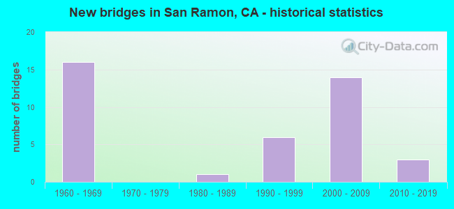
- New bridges - historical statistics
- 161960-1969
- 11980-1989
- 61990-1999
- 142000-2009
- 32010-2019
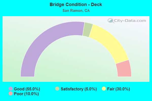
- Bridge Condition - Deck
- 55.0%Good
- 5.0%Satisfactory
- 30.0%Fair
- 10.0%Poor
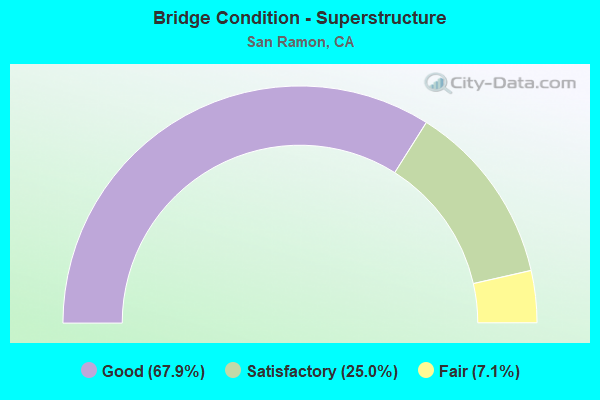
- Bridge Condition - Superstructure
- 67.9%Good
- 25.0%Satisfactory
- 7.1%Fair
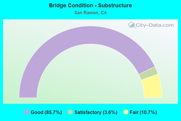
- Bridge Condition - Substructure
- 85.7%Good
- 3.6%Satisfactory
- 10.7%Fair

- Bridge Condition - Channel
- 29.2%Excellent
- 29.2%Very good
- 33.3%Good
- 8.3%Satisfactory
Find on map >> Show street view
Structure Number: 28 0205, Location: 04-CC-680-R3.76-SRMN (Lat: 37.771247, Lng: -121.972625), Route carried "on" structure: City street , Year Built: 1966, Year Reconstructed: 1987, Status: Open, Structure Length: 6.56m (21.52ft), Average Daily Traffic: 3,600 (year 2009), Truck Traffic: 3%, Average Future Daily Traffic: 8,437 (year 2037), Design Load: HS 20+Mod, Features Intersected: INTERSTATE 680, Facility Carried by Structure: NORRIS CANYON ROAD
Minimum Vertical Clearance: 30+ m (98+ ft), Kilometerpoint: 0.000, Lanes on structure: 5, Lanes under structure: 10, Owner: State Highway Agency, Approaching Roadway Width: 23.5m (77.1ft), Material/Design: Concrete continuous, Design/Construction: Box Beam or Girders - Multiple, Number Of Spans In Main Unit: 2, Length of Maximum Span: 32.5m (106.6ft), Curb or Sidewalk Widths: Left: 1.5m (4.9ft), Right: 0.0m, Curb-To-Curb Width: 21.3m (69.9ft), Out-to-Out Width: 23.6m (77.4ft)
Condition: Deck: Fair, Superstructure: Good, Substructure: Good, Operating Rating: 54.1 metric tons, Method Used To Determine Operating Rating: Assigned rating based on Load Factor Design (LFD) reported in metric tons, Inventory Rating: 32.4 metric tons, Method Used To Determine Inventory Rating: Assigned rating based on Load Factor Design (LFD) reported in metric tons, Structural Evaluation: Better than present minimum criteria, Deck Geometry: Somewhat better than minimum adequacy, Underclear: High priority of corrective action, Approach Roadway Alignment: Better than present minimum criteria, Designated Inspection Frequency: Every 24 months, Inspection Date: July 2020, Deck Structure Type: Concrete Cast-file-Place
Find on map >> Show street view
Structure Number: 28 0206, Location: 04-CC-680-R4.18-SRMN (Lat: 37.776797, Lng: -121.975633), Route carried "on" structure: City street , Year Built: 1966, Status: Open, Structure Length: 9.47m (31.07ft), Average Daily Traffic: 12,341 (year 2009), Truck Traffic: 10%, Average Future Daily Traffic: 23,281 (year 2037), Design Load: HS 20+Mod, Features Intersected: INTERSTATE 680, Facility Carried by Structure: CROW CANYON ROAD
Minimum Vertical Clearance: 30+ m (98+ ft), Kilometerpoint: 0.000, Lanes on structure: 8, Lanes under structure: 10, Owner: State Highway Agency, Approaching Roadway Width: 30.2m (99.1ft), Skew: 20 degrees, Material/Design: Concrete continuous, Design/Construction: Box Beam or Girders - Multiple, Number Of Spans In Main Unit: 4, Length of Maximum Span: 26.2m (86.0ft), Curb or Sidewalk Widths: Left: 0.0m, Right: 3.2m (10.5ft), Curb-To-Curb Width: 30.2m (99.1ft), Out-to-Out Width: 34.7m (113.8ft)
Condition: Deck: Fair, Superstructure: Fair, Substructure: Good, Operating Rating: 43.1 metric tons, Method Used To Determine Operating Rating: Load and Resistance Factor Rating (LRFR) rating reported by rating factor(RF) method using HL-93 loadings, Inventory Rating: 33.4 metric tons, Method Used To Determine Inventory Rating: Load and Resistance Factor Rating (LRFR) rating reported by rating factor(RF) method using HL-93 loadings, Structural Evaluation: Somewhat better than minimum adequacy, Deck Geometry: Somewhat better than minimum adequacy, Underclear: Equal to present minimum criteria, Approach Roadway Alignment: Equal to present desirable criteria, Designated Inspection Frequency: Every 24 months, Inspection Date: July 2020, Deck Structure Type: Concrete Cast-file-Place
Find on map >> Show street view
Structure Number: 28 0221, Location: 04-CC-680-R1.09-SRMN (Lat: 37.736964, Lng: -121.950233), Route carried "on" structure: Interstate 680, Year Built: 1966, Year Reconstructed: 1994, Status: Open, Structure Length: 3.87m (12.70ft), Average Daily Traffic: 181,700 (year 2017), Truck Traffic: 6%, Average Future Daily Traffic: 240,974 (year 2042), Design Load: HS 20, Features Intersected: PINE VALLEY ROAD
Minimum Vertical Clearance: 30+ m (98+ ft), Kilometerpoint: 1.090, Lanes on structure: 8, Lanes under structure: 3, Base Highway Network: Yes (Inventory Route: 6, Subroute: 1), Owner: State Highway Agency, Approaching Roadway Width: 42.1m (138.1ft), Skew: 30 degrees, Material/Design: Concrete continuous, Design/Construction: Box Beam or Girders - Multiple, Number Of Spans In Main Unit: 3, Length of Maximum Span: 19.2m (63.0ft), Curb-To-Curb Width: 41.4m (135.8ft), Out-to-Out Width: 42.6m (139.8ft)
Condition: Deck: Poor, Superstructure: Good, Substructure: Good, Operating Rating: 34.7 metric tons, Method Used To Determine Operating Rating: Load and Resistance Factor Rating (LRFR) rating reported by rating factor(RF) method using HL-93 loadings, Inventory Rating: 26.9 metric tons, Method Used To Determine Inventory Rating: Load and Resistance Factor Rating (LRFR) rating reported by rating factor(RF) method using HL-93 loadings, Structural Evaluation: Equal to present minimum criteria, Deck Geometry: Superior to present desirable criteria, Underclear: Equal to present minimum criteria, Approach Roadway Alignment: Equal to present desirable criteria, Length Of Structure Improvement: 3.87m (12.70ft), Designated Inspection Frequency: Every 24 months, Inspection Date: July 2020, Bridge Improvement Cost: $1,652,000, Roadway Improvement Cost: $330,000, Total Project Cost: $2,775,000 ( Estimate for 2021), Deck Structure Type: Concrete Cast-file-Place
Find on map >> Show street view
Structure Number: 28 0222, Location: 04-CC-680-R1.89-SRMN (Lat: 37.747242, Lng: -121.957036), Route carried "on" structure: Interstate 680, Year Built: 1966, Year Reconstructed: 1994, Status: Open, Structure Length: 3.87m (12.70ft), Average Daily Traffic: 181,700 (year 2017), Truck Traffic: 6%, Average Future Daily Traffic: 236,210 (year 2038), Design Load: HS 20, Features Intersected: MONTEVIDEO DRIVE
Minimum Vertical Clearance: 30+ m (98+ ft), Kilometerpoint: 1.890, Lanes on structure: 8, Lanes under structure: 3, Base Highway Network: Yes (Inventory Route: 6, Subroute: 1), Owner: State Highway Agency, Approaching Roadway Width: 42.1m (138.1ft), Skew: 30 degrees, Material/Design: Concrete continuous, Design/Construction: Box Beam or Girders - Multiple, Number Of Spans In Main Unit: 3, Length of Maximum Span: 19.2m (63.0ft), Curb-To-Curb Width: 41.3m (135.5ft), Out-to-Out Width: 42.7m (140.1ft)
Condition: Deck: Poor, Superstructure: Good, Substructure: Good, Operating Rating: 35.6 metric tons, Method Used To Determine Operating Rating: Load and Resistance Factor Rating (LRFR) rating reported by rating factor(RF) method using HL-93 loadings, Inventory Rating: 27.5 metric tons, Method Used To Determine Inventory Rating: Load and Resistance Factor Rating (LRFR) rating reported by rating factor(RF) method using HL-93 loadings, Structural Evaluation: Equal to present minimum criteria, Deck Geometry: Superior to present desirable criteria, Underclear: Equal to present minimum criteria, Approach Roadway Alignment: Equal to present desirable criteria, Length Of Structure Improvement: 3.87m (12.70ft), Designated Inspection Frequency: Every 24 months, Inspection Date: July 2020, Bridge Improvement Cost: $1,653,000, Roadway Improvement Cost: $330,000, Total Project Cost: $2,777,000 ( Estimate for 2021), Deck Structure Type: Concrete Cast-file-Place
Find on map >> Show street view
Structure Number: 28 0224, Location: 04-CC-680-R2.88-SRMN (Lat: 37.759803, Lng: -121.965739), Route carried "on" structure: City street , Year Built: 1966, Year Reconstructed: 1986, Status: Open, Structure Length: 7.44m (24.41ft), Average Daily Traffic: 10,800 (year 1998), Truck Traffic: 3%, Average Future Daily Traffic: 25,822 (year 2040), Design Load: HS 20, Features Intersected: INTERSTATE 680, Facility Carried by Structure: BOLLINGER CYN RD
Minimum Vertical Clearance: 30+ m (98+ ft), Kilometerpoint: 0.000, Lanes on structure: 6, Lanes under structure: 10, Owner: State Highway Agency, Approaching Roadway Width: 26.8m (87.9ft), Skew: 21 degrees, Material/Design: Concrete continuous, Design/Construction: Box Beam or Girders - Multiple, Number Of Spans In Main Unit: 4, Length of Maximum Span: 27.4m (89.9ft), Curb or Sidewalk Widths: Left: 0.0m, Right: 3.4m (11.2ft), Curb-To-Curb Width: 26.8m (87.9ft), Out-to-Out Width: 33.0m (108.3ft)
Condition: Deck: Fair, Superstructure: Satisfactory, Substructure: Satisfactory, Operating Rating: 46.7 metric tons, Method Used To Determine Operating Rating: Load and Resistance Factor Rating (LRFR) rating reported by rating factor(RF) method using HL-93 loadings, Inventory Rating: 30.1 metric tons, Method Used To Determine Inventory Rating: Load and Resistance Factor Rating (LRFR) rating reported by rating factor(RF) method using HL-93 loadings, Structural Evaluation: Equal to present minimum criteria, Deck Geometry: Better than present minimum criteria, Underclear: High priority of corrective action, Approach Roadway Alignment: Equal to present desirable criteria, Designated Inspection Frequency: Every 24 months, Inspection Date: July 2020, Deck Structure Type: Concrete Cast-file-Place
Find on map >> Show street view
Structure Number: 28 0312K, Location: 04-CC-680-14.07-WLC (Lat: 37.894297, Lng: -122.069208), Route carried "on" structure: Ramp Interstate 680, Year Built: 1999, Status: Open, Structure Length: 21.30m (69.88ft), Average Daily Traffic: 5,000 (year 2009), Truck Traffic: 5%, Average Future Daily Traffic: 8,722 (year 2041), Design Load: HS 20+Mod, Features Intersected: E24-S680 CONNECTOR RAMP
Minimum Vertical Clearance: 30+ m (98+ ft), Kilometerpoint: 14.070, Lanes on structure: 1, Lanes under structure: 2, Base Highway Network: Yes, Owner: State Highway Agency, Approaching Roadway Width: 7.3m (24.0ft), Material/Design: Steel, Design/Construction: Stringer/Multi-beam, Number Of Spans In Main Unit: 4, Length of Maximum Span: 64.0m (210.0ft), Curb or Sidewalk Widths: Left: 0.6m (2.0ft), Right: 0.6m (2.0ft), Curb-To-Curb Width: 7.3m (24.0ft), Out-to-Out Width: 8.5m (27.9ft)
Condition: Deck: Fair, Superstructure: Good, Substructure: Good, Operating Rating: 54.1 metric tons, Method Used To Determine Operating Rating: Assigned rating based on Load Factor Design (LFD) reported in metric tons, Inventory Rating: 32.4 metric tons, Method Used To Determine Inventory Rating: Assigned rating based on Load Factor Design (LFD) reported in metric tons, Structural Evaluation: Better than present minimum criteria, Deck Geometry: Better than present minimum criteria, Underclear: Meets minimum limits, Approach Roadway Alignment: Equal to present desirable criteria, Designated Inspection Frequency: Every 24 months, Critical Feature Inspection Frequency: Every 24 months, Inspection Date: January 2021, Critical Feature Inspection Date: July 2020, Deck Structure Type: Concrete Cast-file-Place
Find on map >> Show street view
Structure Number: 28 0316, Location: 04-CC-680-R4.38-SRMN (Lat: 37.779697, Lng: -121.977108), Route carried "on" structure: City street , Year Built: 1992, Status: Open, Structure Length: 10.09m (33.10ft), Average Daily Traffic: 8,400 (year 1998), Truck Traffic: 2%, Average Future Daily Traffic: 19,367 (year 2040), Design Load: HS 20+Mod, Features Intersected: INTERSTATE 680, Facility Carried by Structure: FOSTORIA PARKWAY
Minimum Vertical Clearance: 30+ m (98+ ft), Kilometerpoint: 0.000, Lanes on structure: 5, Lanes under structure: 11, Owner: State Highway Agency, Approaching Roadway Width: 25.3m (83.0ft), Skew: 20 degrees, Material/Design: Prestressed concrete continuous, Design/Construction: Box Beam or Girders - Multiple, Number Of Spans In Main Unit: 2, Length of Maximum Span: 49.9m (163.7ft), Curb or Sidewalk Widths: Left: 0.0m, Right: 3.1m (10.2ft), Curb-To-Curb Width: 25.3m (83.0ft), Out-to-Out Width: 30.5m (100.1ft)
Condition: Deck: Good, Superstructure: Fair, Substructure: Good, Operating Rating: 54.1 metric tons, Method Used To Determine Operating Rating: Assigned rating based on Load Factor Design (LFD) reported in metric tons, Inventory Rating: 32.4 metric tons, Method Used To Determine Inventory Rating: Assigned rating based on Load Factor Design (LFD) reported in metric tons, Structural Evaluation: Somewhat better than minimum adequacy, Deck Geometry: Superior to present desirable criteria, Underclear: Equal to present minimum criteria, Approach Roadway Alignment: Equal to present desirable criteria, Designated Inspection Frequency: Every 24 months, Inspection Date: July 2020, Deck Structure Type: Concrete Cast-file-Place
Find on map >> Show street view
Structure Number: 28C0157, Location: 1.8 MI N COUNTY LINE (Lat: 37.764383, Lng: -121.866583), Route carried "on" structure: County highway , Year Built: 1995, Status: Open, Structure Length: 2.53m (8.30ft), Average Daily Traffic: 7,539 (year 2013), Truck Traffic: 3%, Average Future Daily Traffic: 6,264 (year 2037), Design Load: HS 20, Features Intersected: TASSAJARA CREEK, Facility Carried by Structure: TASSAJARA ROAD
Minimum Vertical Clearance: 30+ m (98+ ft), Kilometerpoint: 0.000, Lanes on structure: 2, Owner: County Highway Agency, Approaching Roadway Width: 10.7m (35.1ft), Skew: 2 degrees, Material/Design: Prestressed concrete, Design/Construction: Box Beam or Girders - Multiple, Number Of Spans In Main Unit: 1, Length of Maximum Span: 24.4m (80.1ft), Curb-To-Curb Width: 10.7m (35.1ft), Out-to-Out Width: 11.7m (38.4ft)
Condition: Deck: Fair, Superstructure: Good, Substructure: Good, Channel: Excellent, Operating Rating: 54.1 metric tons, Method Used To Determine Operating Rating: Assigned rating based on Load Factor Design (LFD) reported in metric tons, Inventory Rating: 32.4 metric tons, Method Used To Determine Inventory Rating: Assigned rating based on Load Factor Design (LFD) reported in metric tons, Structural Evaluation: Better than present minimum criteria, Deck Geometry: Meets minimum limits, Waterway Adequacy: Equal to present desirable criteria, Approach Roadway Alignment: Equal to present minimum criteria, Designated Inspection Frequency: Every 24 months, Inspection Date: November 2020, Deck Structure Type: Concrete Cast-file-Place
Find on map >> Show street view
Structure Number: 28C023, Location: 3.4 MI S WALNUT BLVD (Lat: 37.851497, Lng: -121.647953), Route carried "on" structure: County highway , Year Built: 1996, Status: Open, Structure Length: 5.91m (19.39ft), Average Daily Traffic: 19,806 (year 2013), Truck Traffic: 3%, Average Future Daily Traffic: 32,279 (year 2037), Design Load: HS 20, Features Intersected: UNIMAN/FRISK CREEK, Facility Carried by Structure: VASCO ROAD
Minimum Vertical Clearance: 30+ m (98+ ft), Kilometerpoint: 0.000, Lanes on structure: 2, Base Highway Network: Yes, Owner: County Highway Agency, Approaching Roadway Width: 12.2m (40.0ft), Material/Design: Prestressed concrete continuous, Design/Construction: Box Beam or Girders - Multiple, Number Of Spans In Main Unit: 2, Length of Maximum Span: 38.1m (125.0ft), Curb-To-Curb Width: 12.2m (40.0ft), Out-to-Out Width: 13.3m (43.6ft)
Condition: Deck: Good, Superstructure: Good, Substructure: Good, Channel: Excellent, Operating Rating: 54.1 metric tons, Method Used To Determine Operating Rating: Assigned rating based on Load Factor Design (LFD) reported in metric tons, Inventory Rating: 32.4 metric tons, Method Used To Determine Inventory Rating: Assigned rating based on Load Factor Design (LFD) reported in metric tons, Structural Evaluation: Better than present minimum criteria, Deck Geometry: Somewhat better than minimum adequacy, Waterway Adequacy: Equal to present desirable criteria, Approach Roadway Alignment: Equal to present desirable criteria, Designated Inspection Frequency: Every 24 months, Inspection Date: July 2020, Deck Structure Type: Concrete Cast-file-Place
Find on map >> Show street view
Structure Number: 28C0235, Location: JUST S OF HARCOURT RD (Lat: 37.758767, Lng: -121.905364), Route carried "on" structure: City street , Year Built: 2006, Status: Open, Structure Length: 0.95m (3.12ft), Average Daily Traffic: 5,000 (year 2007), Truck Traffic: 1%, Average Future Daily Traffic: 6,456 (year 2042), Features Intersected: EAST BRANCH ALAMO CREEK, Facility Carried by Structure: BOLLINGER CANYON
Minimum Vertical Clearance: 30+ m (98+ ft), Kilometerpoint: 0.000, Lanes on structure: 7, Base Highway Network: Yes, Owner: City or Municipal Highway Agency, Approaching Roadway Width: 29.5m (96.8ft), Skew: 20 degrees, Material/Design: Steel, Design/Construction: Arch - Deck, Number Of Spans In Main Unit: 1, Length of Maximum Span: 9.5m (31.2ft)
Condition: Superstructure: Good, Substructure: Good, Channel: Good, Operating Rating: 54.1 metric tons, Method Used To Determine Operating Rating: Field evaluation and documented engineering judgment, Inventory Rating: 32.4 metric tons, Method Used To Determine Inventory Rating: Field evaluation and documented engineering judgment, Structural Evaluation: Better than present minimum criteria, Waterway Adequacy: Equal to present desirable criteria, Approach Roadway Alignment: Equal to present desirable criteria, Designated Inspection Frequency: Every 24 months, Inspection Date: March 2020
Find on map >> Show street view
Structure Number: 28C0236, Location: JUST S. OF HARCOURT WAY (Lat: 37.759225, Lng: -121.908100), Route carried "on" structure: City street , Year Built: 2006, Status: Open, Structure Length: 0.91m (2.99ft), Average Daily Traffic: 500 (year 2007), Truck Traffic: 1%, Average Future Daily Traffic: 807 (year 2042), Features Intersected: EAST BRANCH ALAMO CREEK, Facility Carried by Structure: WATERMILL ROAD
Minimum Vertical Clearance: 30+ m (98+ ft), Kilometerpoint: 0.000, Lanes on structure: 2, Owner: City or Municipal Highway Agency, Approaching Roadway Width: 9.7m (31.8ft), Material/Design: Steel, Design/Construction: Arch - Deck, Number Of Spans In Main Unit: 1, Length of Maximum Span: 9.1m (29.9ft)
Condition: Superstructure: Good, Substructure: Good, Channel: Good, Operating Rating: 54.1 metric tons, Method Used To Determine Operating Rating: Field evaluation and documented engineering judgment, Inventory Rating: 32.4 metric tons, Method Used To Determine Inventory Rating: Field evaluation and documented engineering judgment, Structural Evaluation: Better than present minimum criteria, Waterway Adequacy: Equal to present desirable criteria, Approach Roadway Alignment: Equal to present desirable criteria, Designated Inspection Frequency: Every 24 months, Inspection Date: March 2020
Find on map >> Show street view
Structure Number: 28C0237, Location: 0.6 MI E. BOLLINGER PKWY (Lat: 37.762047, Lng: -121.892442), Route carried "on" structure: City street , Year Built: 2006, Status: Open, Structure Length: 0.61m (2.00ft), Average Daily Traffic: 2,000 (year 2007), Truck Traffic: 1%, Average Future Daily Traffic: 3,691 (year 2036), Design Load: HS 20, Features Intersected: EAST BRANCH ALAMO CREEK, Facility Carried by Structure: WINDEMERE PARKWAY
Minimum Vertical Clearance: 30+ m (98+ ft), Kilometerpoint: 0.000, Lanes on structure: 4, Owner: City or Municipal Highway Agency, Approaching Roadway Width: 19.2m (63.0ft), Skew: 20 degrees, Material/Design: Concrete, Design/Construction: Slab, Number Of Spans In Main Unit: 1, Length of Maximum Span: 6.1m (20.0ft)
Condition: Deck: Good, Superstructure: Good, Substructure: Good, Channel: Good, Operating Rating: 54.1 metric tons, Method Used To Determine Operating Rating: Field evaluation and documented engineering judgment, Inventory Rating: 32.4 metric tons, Method Used To Determine Inventory Rating: Field evaluation and documented engineering judgment, Structural Evaluation: Better than present minimum criteria, Waterway Adequacy: Equal to present desirable criteria, Approach Roadway Alignment: Equal to present desirable criteria, Designated Inspection Frequency: Every 48 months, Inspection Date: April 2018
Find on map >> Show street view
Structure Number: 28C0238, Location: 1 MI E. BOLLINGER PKWY (Lat: 37.755358, Lng: -121.888717), Route carried "on" structure: City street , Year Built: 2005, Status: Open, Structure Length: 0.79m (2.59ft), Average Daily Traffic: 2,000 (year 2007), Truck Traffic: 1%, Average Future Daily Traffic: 3,765 (year 2042), Features Intersected: ALAMO CREEK SOUTH FORK, Facility Carried by Structure: WINDEMERE PARKWAY
Minimum Vertical Clearance: 30+ m (98+ ft), Kilometerpoint: 0.000, Lanes on structure: 4, Owner: City or Municipal Highway Agency, Approaching Roadway Width: 10.4m (34.1ft), Skew: 20 degrees, Material/Design: Steel, Design/Construction: Arch - Deck, Number Of Spans In Main Unit: 1, Length of Maximum Span: 7.9m (25.9ft)
Condition: Superstructure: Good, Substructure: Good, Channel: Good, Operating Rating: 54.1 metric tons, Method Used To Determine Operating Rating: Field evaluation and documented engineering judgment, Inventory Rating: 32.4 metric tons, Method Used To Determine Inventory Rating: Field evaluation and documented engineering judgment, Structural Evaluation: Better than present minimum criteria, Waterway Adequacy: Equal to present desirable criteria, Approach Roadway Alignment: Equal to present desirable criteria, Designated Inspection Frequency: Every 24 months, Inspection Date: March 2020
Find on map >> Show street view
Structure Number: 28C0240L, Location: 1 MI E CROW CANYON RD (Lat: 37.769122, Lng: -121.907989), Route carried "on" structure: City street , Year Built: 2006, Status: Open, Structure Length: 4.26m (13.98ft), Average Daily Traffic: 5,000 (year 2007), Truck Traffic: 1%, Average Future Daily Traffic: 6,994 (year 2042), Design Load: HS 20+Mod, Features Intersected: MAIN BRANCH ALAMO CREEK, Facility Carried by Structure: BOLLINGER CANYON
Minimum Vertical Clearance: 30+ m (98+ ft), Kilometerpoint: 0.000, Lanes on structure: 3, Base Highway Network: Yes, Owner: City or Municipal Highway Agency, Approaching Roadway Width: 14.3m (46.9ft), Skew: 3 degrees, Material/Design: Prestressed concrete, Design/Construction: Box Beam or Girders - Multiple, Number Of Spans In Main Unit: 1, Length of Maximum Span: 40.8m (133.9ft), Curb or Sidewalk Widths: Left: 2.1m (6.9ft), Right: 0.0m, Curb-To-Curb Width: 14.2m (46.6ft), Out-to-Out Width: 16.9m (55.4ft)
Condition: Deck: Satisfactory, Superstructure: Satisfactory, Substructure: Good, Channel: Very good, Operating Rating: 54.1 metric tons, Method Used To Determine Operating Rating: Assigned rating based on Load Factor Design (LFD) reported in metric tons, Inventory Rating: 32.4 metric tons, Method Used To Determine Inventory Rating: Assigned rating based on Load Factor Design (LFD) reported in metric tons, Structural Evaluation: Equal to present minimum criteria, Deck Geometry: Somewhat better than minimum adequacy, Waterway Adequacy: Equal to present desirable criteria, Approach Roadway Alignment: Equal to present desirable criteria, Designated Inspection Frequency: Every 24 months, Inspection Date: March 2020, Deck Structure Type: Concrete Cast-file-Place
Find on map >> Show street view
Structure Number: 28C0240R, Location: 1 MI E CROW CANYON RD (Lat: 37.768764, Lng: -121.908119), Route carried "on" structure: City street , Year Built: 2006, Status: Open, Structure Length: 4.27m (14.01ft), Average Daily Traffic: 5,000 (year 2007), Truck Traffic: 1%, Average Future Daily Traffic: 6,994 (year 2042), Design Load: HS 20+Mod, Features Intersected: MAIN BRANCH ALAMO CREEK, Facility Carried by Structure: BOLLINGER CANYON
Minimum Vertical Clearance: 30+ m (98+ ft), Kilometerpoint: 0.000, Lanes on structure: 2, Base Highway Network: Yes, Owner: City or Municipal Highway Agency, Approaching Roadway Width: 14.2m (46.6ft), Skew: 3 degrees, Material/Design: Prestressed concrete, Design/Construction: Box Beam or Girders - Multiple, Number Of Spans In Main Unit: 1, Length of Maximum Span: 40.9m (134.2ft), Curb or Sidewalk Widths: Left: 0.0m, Right: 2.1m (6.9ft), Curb-To-Curb Width: 14.2m (46.6ft), Out-to-Out Width: 16.9m (55.4ft)
Condition: Deck: Good, Superstructure: Good, Substructure: Good, Channel: Very good, Operating Rating: 54.1 metric tons, Method Used To Determine Operating Rating: Assigned rating based on Load Factor Design (LFD) reported in metric tons, Inventory Rating: 32.4 metric tons, Method Used To Determine Inventory Rating: Assigned rating based on Load Factor Design (LFD) reported in metric tons, Structural Evaluation: Better than present minimum criteria, Deck Geometry: Superior to present desirable criteria, Waterway Adequacy: Equal to present desirable criteria, Approach Roadway Alignment: Equal to present desirable criteria, Designated Inspection Frequency: Every 24 months, Inspection Date: March 2020, Deck Structure Type: Concrete Cast-file-Place
Find on map >> Show street view
Structure Number: 28C0242, Location: 1/10 MI E. OF N. MONARCH (Lat: 37.775806, Lng: -121.903344), Route carried "on" structure: City street , Year Built: 2007, Status: Open, Structure Length: 3.93m (12.89ft), Average Daily Traffic: 1,000 (year 2007), Truck Traffic: 1%, Average Future Daily Traffic: 3,177 (year 2040), Design Load: HS 20+Mod, Features Intersected: ALAMO CREEK, Facility Carried by Structure: JAPONICA WAY
Minimum Vertical Clearance: 30+ m (98+ ft), Kilometerpoint: 0.000, Lanes on structure: 2, Owner: City or Municipal Highway Agency, Approaching Roadway Width: 12.2m (40.0ft), Skew: 9 degrees, Material/Design: Prestressed concrete, Design/Construction: Box Beam or Girders - Multiple, Number Of Spans In Main Unit: 1, Length of Maximum Span: 37.8m (124.0ft), Curb or Sidewalk Widths: Left: 2.4m (7.9ft), Right: 1.5m (4.9ft), Curb-To-Curb Width: 12.2m (40.0ft), Out-to-Out Width: 16.8m (55.1ft)
Condition: Deck: Good, Superstructure: Satisfactory, Substructure: Fair, Channel: Very good, Operating Rating: 54.1 metric tons, Method Used To Determine Operating Rating: Assigned rating based on Load Factor Design (LFD) reported in metric tons, Inventory Rating: 32.4 metric tons, Method Used To Determine Inventory Rating: Assigned rating based on Load Factor Design (LFD) reported in metric tons, Structural Evaluation: Somewhat better than minimum adequacy, Deck Geometry: Equal to present desirable criteria, Waterway Adequacy: Equal to present desirable criteria, Approach Roadway Alignment: Equal to present desirable criteria, Designated Inspection Frequency: Every 24 months, Inspection Date: March 2020, Deck Structure Type: Concrete Cast-file-Place
Find on map >> Show street view
Structure Number: 28C0244, Location: 0.1 MI W. OF DOUGHERTY RD (Lat: 37.773247, Lng: -121.925958), Route carried "on" structure: City street , Year Built: 2005, Status: Open, Structure Length: 2.25m (7.38ft), Average Daily Traffic: 2,760 (year 2010), Truck Traffic: 2%, Average Future Daily Traffic: 5,978 (year 2040), Features Intersected: WEST BRANCH ALAMO CREEK, Facility Carried by Structure: BOLLINGER CANYON
Minimum Vertical Clearance: 30+ m (98+ ft), Kilometerpoint: 0.000, Lanes on structure: 7, Base Highway Network: Yes, Owner: City or Municipal Highway Agency, Approaching Roadway Width: 36.3m (119.1ft), Skew: 2 degrees, Material/Design: Steel, Design/Construction: Arch - Deck, Number Of Spans In Main Unit: 1, Number Of Approach Spans: 2, Length of Maximum Span: 12.3m (40.4ft)
Condition: Superstructure: Good, Substructure: Good, Channel: Excellent, Operating Rating: 54.1 metric tons, Method Used To Determine Operating Rating: Field evaluation and documented engineering judgment, Inventory Rating: 32.4 metric tons, Method Used To Determine Inventory Rating: Field evaluation and documented engineering judgment, Structural Evaluation: Better than present minimum criteria, Waterway Adequacy: Equal to present desirable criteria, Approach Roadway Alignment: Equal to present desirable criteria, Designated Inspection Frequency: Every 24 months, Inspection Date: March 2020
Find on map >> Show street view
Structure Number: 28C0245, Location: 0.1 MI W OF DOUGHERTY RD (Lat: 37.778039, Lng: -121.924756), Route carried "on" structure: City street , Year Built: 2005, Status: Open, Structure Length: 3.24m (10.63ft), Average Daily Traffic: 2,300 (year 2011), Truck Traffic: 2%, Average Future Daily Traffic: 5,434 (year 2040), Features Intersected: WEST BRANCH ALAMO CREEK, Facility Carried by Structure: N. GALE RIDGE RD
Minimum Vertical Clearance: 30+ m (98+ ft), Kilometerpoint: 0.000, Lanes on structure: 2, Owner: City or Municipal Highway Agency, Approaching Roadway Width: 12.0m (39.4ft), Material/Design: Steel, Design/Construction: Arch - Deck, Number Of Spans In Main Unit: 3, Length of Maximum Span: 13.1m (43.0ft)
Condition: Superstructure: Good, Substructure: Fair, Channel: Excellent, Operating Rating: 54.1 metric tons, Method Used To Determine Operating Rating: Field evaluation and documented engineering judgment, Inventory Rating: 32.4 metric tons, Method Used To Determine Inventory Rating: Field evaluation and documented engineering judgment, Structural Evaluation: Somewhat better than minimum adequacy, Waterway Adequacy: Equal to present desirable criteria, Approach Roadway Alignment: Equal to present desirable criteria, Designated Inspection Frequency: Every 24 months, Inspection Date: March 2020
Find on map >> Show street view
Structure Number: 28C0246, Location: .1 MI S OF E BRANCH PKWY (Lat: 37.751642, Lng: -121.910117), Route carried "on" structure: City street , Year Built: 2005, Status: Open, Structure Length: 0.92m (3.02ft), Average Daily Traffic: 5,000 (year 2007), Truck Traffic: 1%, Average Future Daily Traffic: 6,456 (year 2042), Features Intersected: E BRANCH PKWY, Facility Carried by Structure: BOLLINGER CANYON R
Minimum Vertical Clearance: 30+ m (98+ ft), Kilometerpoint: 0.000, Lanes on structure: 4, Base Highway Network: Yes, Owner: City or Municipal Highway Agency, Approaching Roadway Width: 20.1m (65.9ft), Skew: 20 degrees, Material/Design: Steel, Design/Construction: Arch - Deck, Number Of Spans In Main Unit: 1, Length of Maximum Span: 9.2m (30.2ft)
Condition: Superstructure: Good, Substructure: Good, Channel: Good, Operating Rating: 54.1 metric tons, Method Used To Determine Operating Rating: Field evaluation and documented engineering judgment, Inventory Rating: 32.4 metric tons, Method Used To Determine Inventory Rating: Field evaluation and documented engineering judgment, Structural Evaluation: Better than present minimum criteria, Waterway Adequacy: Equal to present desirable criteria, Approach Roadway Alignment: Equal to present desirable criteria, Designated Inspection Frequency: Every 24 months, Inspection Date: March 2020
Find on map >> Show street view
Structure Number: 28C0247, Location: .3 MI W. CAMINO TASSAJARA (Lat: 37.746867, Lng: -121.878264), Route carried "on" structure: City street , Year Built: 2007, Status: Open, Structure Length: 1.00m (3.28ft), Average Daily Traffic: 2,000 (year 2007), Truck Traffic: 1%, Average Future Daily Traffic: 3,765 (year 2042), Features Intersected: CAMINO TASSAJARA, Facility Carried by Structure: WINDEMERE PARKWAY
Minimum Vertical Clearance: 30+ m (98+ ft), Kilometerpoint: 0.000, Lanes on structure: 4, Owner: City or Municipal Highway Agency, Approaching Roadway Width: 10.4m (34.1ft), Skew: 20 degrees, Material/Design: Steel, Design/Construction: Arch - Deck, Number Of Spans In Main Unit: 1, Length of Maximum Span: 9.7m (31.8ft)
Condition: Superstructure: Good, Substructure: Good, Channel: Very good, Operating Rating: 54.1 metric tons, Method Used To Determine Operating Rating: Field evaluation and documented engineering judgment, Inventory Rating: 32.4 metric tons, Method Used To Determine Inventory Rating: Field evaluation and documented engineering judgment, Structural Evaluation: Better than present minimum criteria, Waterway Adequacy: Somewhat better than minimum adequacy, Approach Roadway Alignment: Equal to present desirable criteria, Designated Inspection Frequency: Every 24 months, Inspection Date: March 2020
Find on map >> Show street view
Structure Number: 28C0249, Location: .2 MI W, CAMINO TASSAJARA (Lat: 37.749336, Lng: -121.875744), Route carried "on" structure: City street , Year Built: 2007, Status: Open, Structure Length: 12.00m (39.37ft), Average Daily Traffic: 2,000 (year 2007), Truck Traffic: 1%, Average Future Daily Traffic: 3,765 (year 2042), Design Load: HS 20, Features Intersected: CAMINO TASSAJARA, Facility Carried by Structure: WINDEMERE PARKWAY
Minimum Vertical Clearance: 30+ m (98+ ft), Kilometerpoint: 0.000, Lanes on structure: 4, Owner: City or Municipal Highway Agency, Approaching Roadway Width: 20.7m (67.9ft), Skew: 30 degrees, Material/Design: Prestressed concrete, Design/Construction: Box Beam or Girders - Single/Spread, Number Of Spans In Main Unit: 1, Number Of Approach Spans: 6, Length of Maximum Span: 46.0m (150.9ft), Curb or Sidewalk Widths: Left: 1.5m (4.9ft), Right: 1.5m (4.9ft), Curb-To-Curb Width: 20.7m (67.9ft), Out-to-Out Width: 26.2m (86.0ft)
Condition: Deck: Fair, Superstructure: Satisfactory, Substructure: Good, Channel: Satisfactory, Operating Rating: 54.1 metric tons, Method Used To Determine Operating Rating: Assigned rating based on Load Factor Design (LFD) reported in metric tons, Inventory Rating: 32.4 metric tons, Method Used To Determine Inventory Rating: Assigned rating based on Load Factor Design (LFD) reported in metric tons, Structural Evaluation: Equal to present minimum criteria, Deck Geometry: Superior to present desirable criteria, Waterway Adequacy: Somewhat better than minimum adequacy, Approach Roadway Alignment: Equal to present desirable criteria, Designated Inspection Frequency: Every 24 months, Inspection Date: March 2020, Deck Structure Type: Concrete Cast-file-Place
Find on map >> Show street view
Structure Number: 28C0254, Location: 0.2 MI S. OF BOLLINGER CY (Lat: 37.770767, Lng: -121.926367), Route carried "on" structure: City street , Year Built: 2015, Status: Open, Structure Length: 9.51m (31.20ft), Average Daily Traffic: 2,760 (year 2015), Truck Traffic: 2%, Average Future Daily Traffic: 5,978 (year 2040), Design Load: HS 20+Mod, Features Intersected: WEST BRANCH ALAMO CREEK, Facility Carried by Structure: DOUGHERTY ROAD
Minimum Vertical Clearance: 30+ m (98+ ft), Kilometerpoint: 0.000, Lanes on structure: 6, Base Highway Network: Yes, Owner: City or Municipal Highway Agency, Approaching Roadway Width: 32.9m (107.9ft), Skew: 33 degrees, Material/Design: Prestressed concrete continuous, Design/Construction: Box Beam or Girders - Multiple, Number Of Spans In Main Unit: 2, Length of Maximum Span: 48.8m (160.1ft), Curb or Sidewalk Widths: Left: 1.5m (4.9ft), Right: 2.4m (7.9ft), Curb-To-Curb Width: 28.0m (91.9ft), Out-to-Out Width: 37.5m (123.0ft)
Condition: Deck: Good, Superstructure: Good, Substructure: Good, Channel: Excellent, Operating Rating: 54.1 metric tons, Method Used To Determine Operating Rating: Assigned rating based on Load Factor Design (LFD) reported in metric tons, Inventory Rating: 32.4 metric tons, Method Used To Determine Inventory Rating: Assigned rating based on Load Factor Design (LFD) reported in metric tons, Structural Evaluation: Better than present minimum criteria, Deck Geometry: Superior to present desirable criteria, Waterway Adequacy: Equal to present desirable criteria, Approach Roadway Alignment: Equal to present desirable criteria, Designated Inspection Frequency: Every 24 months, Inspection Date: March 2020, Deck Structure Type: Concrete Cast-file-Place
Find on map >> Show street view
Structure Number: 28C0255, Location: AT BOLLINGER CANYON RD (Lat: 37.748172, Lng: -121.916611), Route carried "on" structure: County highway , Year Built: 2007, Status: Open, Structure Length: 9.05m (29.69ft), Average Daily Traffic: 100 (year 2014), Average Future Daily Traffic: 205 (year 2038), Design Load: HS 20+Mod, Features Intersected: LOWER M. BRANCH ALAMO CR, Facility Carried by Structure: DOUGHERTY
Minimum Vertical Clearance: 30+ m (98+ ft), Kilometerpoint: 0.000, Lanes on structure: 6, Owner: City or Municipal Highway Agency, Approaching Roadway Width: 28.3m (92.8ft), Skew: 31 degrees, Material/Design: Prestressed concrete continuous, Design/Construction: Box Beam or Girders - Single/Spread, Number Of Spans In Main Unit: 3, Length of Maximum Span: 41.1m (134.8ft), Curb or Sidewalk Widths: Left: 2.4m (7.9ft), Right: 1.5m (4.9ft), Curb-To-Curb Width: 28.3m (92.8ft), Out-to-Out Width: 37.8m (124.0ft)
Condition: Deck: Good, Superstructure: Satisfactory, Substructure: Good, Channel: Good, Operating Rating: 54.1 metric tons, Method Used To Determine Operating Rating: Assigned rating based on Load Factor Design (LFD) reported in metric tons, Inventory Rating: 32.4 metric tons, Method Used To Determine Inventory Rating: Assigned rating based on Load Factor Design (LFD) reported in metric tons, Structural Evaluation: Equal to present minimum criteria, Deck Geometry: Superior to present desirable criteria, Waterway Adequacy: Equal to present desirable criteria, Approach Roadway Alignment: Equal to present desirable criteria, Designated Inspection Frequency: Every 24 months, Inspection Date: March 2020, Deck Structure Type: Concrete Cast-file-Place
Find on map >> Show street view
Structure Number: 28C0333, Location: 0.9 MI EAST OF I-680 (Lat: 37.731267, Lng: -121.928492), Route carried "on" structure: City street , Year Built: 1962, Status: Open, Structure Length: 0.98m (3.22ft), Average Daily Traffic: 26,700 (year 2010), Truck Traffic: 2%, Average Future Daily Traffic: 21,439 (year 2042), Features Intersected: SOUTH SAN RAMON CREEK, Facility Carried by Structure: ALCOSTA BLVD
Minimum Vertical Clearance: 30+ m (98+ ft), Kilometerpoint: 0.000, Lanes on structure: 4, Owner: City or Municipal Highway Agency, Approaching Roadway Width: 20.7m (67.9ft), Skew: 31 degrees, Material/Design: Concrete continuous, Design/Construction: Culvert, Number Of Spans In Main Unit: 3, Length of Maximum Span: 3.2m (10.5ft), Curb or Sidewalk Widths: Left: 1.4m (4.6ft), Right: 1.4m (4.6ft), Curb-To-Curb Width: 20.7m (67.9ft), Out-to-Out Width: 29.0m (95.1ft)
Condition: Channel: Good, Culverts: Good, Operating Rating: 40.5 metric tons, Method Used To Determine Operating Rating: Load Factor (LF), Inventory Rating: 24.3 metric tons, Method Used To Determine Inventory Rating: Load Factor (LF), Structural Evaluation: Equal to present minimum criteria, Deck Geometry: Superior to present desirable criteria, Waterway Adequacy: Better than present minimum criteria, Approach Roadway Alignment: Better than present minimum criteria, Designated Inspection Frequency: Every 24 months, Inspection Date: March 2020
Find on map >> Show street view
Structure Number: 28C0428, Location: 0.2 MI W DOUGHERTY RD (Lat: 37.739067, Lng: -121.916164), Route carried "on" structure: City street , Year Built: 1967, Status: Open, Structure Length: 1.01m (3.31ft), Average Daily Traffic: 1,000 (year 1982), Truck Traffic: 5%, Average Future Daily Traffic: 3,314 (year 2040), Features Intersected: ALAMO CREEK, Facility Carried by Structure: OLD RANCH RD
Minimum Vertical Clearance: 30+ m (98+ ft), Kilometerpoint: 0.000, Lanes on structure: 5, Owner: City or Municipal Highway Agency, Approaching Roadway Width: 19.7m (64.6ft), Skew: 22 degrees, Material/Design: Concrete continuous, Design/Construction: Culvert, Number Of Spans In Main Unit: 3, Length of Maximum Span: 3.0m (9.8ft), Curb-To-Curb Width: 19.7m (64.6ft), Out-to-Out Width: 22.0m (72.2ft)
Condition: Channel: Very good, Culverts: Good, Operating Rating: 40.5 metric tons, Method Used To Determine Operating Rating: Field evaluation and documented engineering judgment, Inventory Rating: 24.3 metric tons, Method Used To Determine Inventory Rating: Field evaluation and documented engineering judgment, Structural Evaluation: Equal to present minimum criteria, Deck Geometry: Meets minimum limits, Waterway Adequacy: Equal to present desirable criteria, Approach Roadway Alignment: Better than present minimum criteria, Designated Inspection Frequency: Every 24 months, Inspection Date: March 2020
Find on map >> Show street view
Structure Number: 28C0429, Location: 0.5 MI W ALCOSTA BLVD (Lat: 37.740764, Lng: -121.937953), Route carried "on" structure: City street , Year Built: 1967, Status: Open, Structure Length: 1.16m (3.81ft), Average Daily Traffic: 9,000 (year 2010), Truck Traffic: 1%, Average Future Daily Traffic: 2,173 (year 2040), Features Intersected: SOUTH SAN RAMON CREEK, Facility Carried by Structure: PINE VALLEY RD
Minimum Vertical Clearance: 30+ m (98+ ft), Kilometerpoint: 0.000, Lanes on structure: 2, Owner: City or Municipal Highway Agency, Approaching Roadway Width: 12.2m (40.0ft), Material/Design: Concrete continuous, Design/Construction: Culvert, Number Of Spans In Main Unit: 3, Length of Maximum Span: 3.7m (12.1ft), Curb-To-Curb Width: 12.2m (40.0ft), Out-to-Out Width: 15.6m (51.2ft)
Condition: Channel: Good, Culverts: Good, Operating Rating: 40.5 metric tons, Method Used To Determine Operating Rating: Field evaluation and documented engineering judgment, Inventory Rating: 24.3 metric tons, Method Used To Determine Inventory Rating: Field evaluation and documented engineering judgment, Structural Evaluation: Equal to present minimum criteria, Deck Geometry: Somewhat better than minimum adequacy, Waterway Adequacy: Equal to present desirable criteria, Approach Roadway Alignment: Superior to present desirable criteria, Designated Inspection Frequency: Every 24 months, Inspection Date: March 2020
Find on map >> Show street view
Structure Number: 28C0453, Location: 0.3 MI S OLD RANCH RD (Lat: 37.734319, Lng: -121.913656), Route carried "on" structure: City street , Year Built: 1990, Status: Open, Structure Length: 3.11m (10.20ft), Average Daily Traffic: 700 (year 2011), Truck Traffic: 1%, Average Future Daily Traffic: 2,173 (year 2040), Design Load: HS 20+Mod, Features Intersected: ALAMO CREEK, Facility Carried by Structure: BENT CREEK DRIVE
Minimum Vertical Clearance: 30+ m (98+ ft), Kilometerpoint: 0.000, Lanes on structure: 2, Owner: City or Municipal Highway Agency, Approaching Roadway Width: 8.5m (27.9ft), Material/Design: Prestressed concrete, Design/Construction: Box Beam or Girders - Multiple, Number Of Spans In Main Unit: 1, Length of Maximum Span: 30.6m (100.4ft), Curb or Sidewalk Widths: Left: 2.4m (7.9ft), Right: 0.0m, Curb-To-Curb Width: 8.5m (27.9ft), Out-to-Out Width: 12.1m (39.7ft)
Condition: Deck: Good, Superstructure: Satisfactory, Substructure: Good, Channel: Very good, Operating Rating: 54.1 metric tons, Method Used To Determine Operating Rating: Assigned rating based on Load Factor Design (LFD) reported in metric tons, Inventory Rating: 32.4 metric tons, Method Used To Determine Inventory Rating: Assigned rating based on Load Factor Design (LFD) reported in metric tons, Structural Evaluation: Equal to present minimum criteria, Deck Geometry: Somewhat better than minimum adequacy, Waterway Adequacy: Equal to present desirable criteria, Approach Roadway Alignment: Equal to present desirable criteria, Designated Inspection Frequency: Every 24 months, Inspection Date: March 2020, Deck Structure Type: Concrete Cast-file-Place
Find on map >> Show street view
Structure Number: 28C0501, Location: 0.4 MI. S.OF DAVISON RD (Lat: 37.984081, Lng: -121.790250), Route carried "on" structure: City street , Year Built: 1985, Status: Open, Structure Length: 2.86m (9.38ft), Average Daily Traffic: 500 (year 2016), Truck Traffic: 1%, Average Future Daily Traffic: 712 (year 2038), Features Intersected: CONTRA COSTA CANAL, Facility Carried by Structure: BARMOUTH DRIVE
Minimum Vertical Clearance: 30+ m (98+ ft), Kilometerpoint: 0.000, Lanes on structure: 2, Owner: City or Municipal Highway Agency, Approaching Roadway Width: 12.2m (40.0ft), Material/Design: Prestressed concrete, Design/Construction: Stringer/Multi-beam, Number Of Spans In Main Unit: 1, Length of Maximum Span: 27.4m (89.9ft), Curb or Sidewalk Widths: Left: 1.5m (4.9ft), Right: 1.5m (4.9ft), Curb-To-Curb Width: 12.2m (40.0ft), Out-to-Out Width: 15.8m (51.8ft)
Condition: Deck: Good, Superstructure: Good, Substructure: Good, Channel: Very good, Operating Rating: 54.1 metric tons, Method Used To Determine Operating Rating: Field evaluation and documented engineering judgment, Inventory Rating: 32.4 metric tons, Method Used To Determine Inventory Rating: Field evaluation and documented engineering judgment, Structural Evaluation: Better than present minimum criteria, Deck Geometry: Equal to present desirable criteria, Waterway Adequacy: Equal to present desirable criteria, Approach Roadway Alignment: Equal to present desirable criteria, Designated Inspection Frequency: Every 48 months, Inspection Date: January 2021, Deck Structure Type: Concrete Cast-file-Place, Wearing Surface/Protective System: Wearing Surface: Bituminous
Find on map >> Show street view
Structure Number: 28C0505, Location: .2 MI E OF SAN RAMON BLVD (Lat: 37.734644, Lng: -121.954150), Route carried "on" structure: City street , Year Built: 2000, Status: Open, Structure Length: 1.16m (3.81ft), Average Daily Traffic: 100 (year 2000), Truck Traffic: 1%, Average Future Daily Traffic: 307 (year 2042), Features Intersected: SAN RAMON VALLEY BLVD, Facility Carried by Structure: WESTSIDE DRIVE
Minimum Vertical Clearance: 30+ m (98+ ft), Kilometerpoint: 0.000, Lanes on structure: 2, Base Highway Network: Yes, Owner: City or Municipal Highway Agency, Approaching Roadway Width: 11.0m (36.1ft), Skew: 5 degrees, Material/Design: Steel, Design/Construction: Arch - Deck, Number Of Spans In Main Unit: 1, Length of Maximum Span: 11.6m (38.1ft)
Condition: Superstructure: Good, Substructure: Fair, Channel: Satisfactory, Operating Rating: 54.1 metric tons, Method Used To Determine Operating Rating: Field evaluation and documented engineering judgment, Inventory Rating: 32.4 metric tons, Method Used To Determine Inventory Rating: Field evaluation and documented engineering judgment, Structural Evaluation: Somewhat better than minimum adequacy, Waterway Adequacy: Equal to present minimum criteria, Approach Roadway Alignment: Equal to present desirable criteria, Designated Inspection Frequency: Every 24 months, Inspection Date: March 2020
Find on map >> Show street view
Structure Number: 28C0507, Location: 1.2 MI S. OF BOLLINGER CY (Lat: 37.757500, Lng: -121.920167), Route carried "on" structure: City street , Year Built: 2015, Status: Open, Structure Length: 4.02m (13.19ft), Average Daily Traffic: 2,760 (year 2015), Truck Traffic: 2%, Average Future Daily Traffic: 5,978 (year 2040), Design Load: HL 93, Features Intersected: WEST BRANCH ALAMO CREEK, Facility Carried by Structure: DOUGHERTY ROAD
Minimum Vertical Clearance: 30+ m (98+ ft), Kilometerpoint: 0.000, Lanes on structure: 7, Base Highway Network: Yes, Owner: City or Municipal Highway Agency, Approaching Roadway Width: 30.5m (100.1ft), Skew: 30 degrees, Material/Design: Prestressed concrete, Design/Construction: Box Beam or Girders - Multiple, Number Of Spans In Main Unit: 1, Length of Maximum Span: 38.9m (127.6ft), Curb or Sidewalk Widths: Left: 1.5m (4.9ft), Right: 3.7m (12.1ft), Curb-To-Curb Width: 30.5m (100.1ft), Out-to-Out Width: 37.5m (123.0ft)
Condition: Deck: Good, Superstructure: Satisfactory, Substructure: Good, Channel: Excellent, Operating Rating: 42.1 metric tons, Method Used To Determine Operating Rating: Assigned ratings based on Load and Resistance Factor Design (LRFD) reported by rating factor (RF) using HL93 loadings, Inventory Rating: 32.4 metric tons, Method Used To Determine Inventory Rating: Assigned ratings based on Load and Resistance Factor Design (LRFD) reported by rating factor (RF) using HL93 loadings, Structural Evaluation: Equal to present minimum criteria, Deck Geometry: Better than present minimum criteria, Waterway Adequacy: Equal to present desirable criteria, Approach Roadway Alignment: Equal to present desirable criteria, Designated Inspection Frequency: Every 24 months, Inspection Date: March 2020, Deck Structure Type: Concrete Cast-file-Place
Find on map >> Show street view
Structure Number: 28C0508, Location: 1.0 MI S. OF BOLLINGER CY (Lat: 37.760058, Lng: -121.920678), Route carried "on" structure: City street , Year Built: 2015, Status: Open, Structure Length: 4.02m (13.19ft), Average Daily Traffic: 2,760 (year 2015), Truck Traffic: 2%, Average Future Daily Traffic: 5,978 (year 2040), Design Load: HL 93, Features Intersected: WEST BRANCH ALAMO CREEK, Facility Carried by Structure: DOUGHERTY ROAD
Minimum Vertical Clearance: 30+ m (98+ ft), Kilometerpoint: 0.000, Lanes on structure: 6, Base Highway Network: Yes, Owner: City or Municipal Highway Agency, Approaching Roadway Width: 13.4m (44.0ft), Skew: 30 degrees, Material/Design: Prestressed concrete, Design/Construction: Box Beam or Girders - Multiple, Number Of Spans In Main Unit: 1, Length of Maximum Span: 38.9m (127.6ft), Curb or Sidewalk Widths: Left: 1.5m (4.9ft), Right: 3.7m (12.1ft), Curb-To-Curb Width: 26.8m (87.9ft), Out-to-Out Width: 37.5m (123.0ft)
Condition: Deck: Good, Superstructure: Good, Substructure: Good, Channel: Excellent, Operating Rating: 42.1 metric tons, Method Used To Determine Operating Rating: Assigned ratings based on Load and Resistance Factor Design (LRFD) reported by rating factor (RF) using HL93 loadings, Inventory Rating: 32.4 metric tons, Method Used To Determine Inventory Rating: Assigned ratings based on Load and Resistance Factor Design (LRFD) reported by rating factor (RF) using HL93 loadings, Structural Evaluation: Better than present minimum criteria, Deck Geometry: Better than present minimum criteria, Waterway Adequacy: Equal to present desirable criteria, Approach Roadway Alignment: Equal to present desirable criteria, Designated Inspection Frequency: Every 24 months, Inspection Date: March 2020, Deck Structure Type: Concrete Cast-file-Place
Find on map >> Show street view
Structure Number: 28 0205, Location: 04-CC-680-R3.76-SRMN (Lat: 37.771247, Lng: -121.972625), Route carried "under" structure: Interstate 680, Year Built: 1966, Structure Length: 0. m, Average Daily Traffic: 170,100 (year 2017), Truck Traffic: 6%, Features Intersected: INTERSTATE 680, Facility Carried by Structure: NORRIS CANYON ROAD
Minimum Vertical Clearance: 5.05m (16.57ft), Kilometerpoint: 3.760, Lanes on structure: 5, Lanes under structure: 10, Material/Design: Concrete continuous, Design/Construction: Box Beam or Girders - Multiple, Length of Maximum Span: 32.5m (106.6ft)
Find on map >> Show street view
Structure Number: 28 0206, Location: 04-CC-680-R4.18-SRMN (Lat: 37.776797, Lng: -121.975633), Route carried "under" structure: Interstate 680, Year Built: 1966, Structure Length: 0. m, Average Daily Traffic: 176,400 (year 2017), Truck Traffic: 6%, Features Intersected: INTERSTATE 680, Facility Carried by Structure: CROW CANYON ROAD
Minimum Vertical Clearance: 5.16m (16.93ft), Kilometerpoint: 4.180, Lanes on structure: 8, Lanes under structure: 8, Material/Design: Concrete continuous, Design/Construction: Box Beam or Girders - Multiple, Length of Maximum Span: 26.2m (86.0ft)
Find on map >> Show street view
Structure Number: 28 0206, Location: 04-CC-680-R4.18-SRMN (Lat: 37.776797, Lng: -121.975633), Route carried "under" structure: Ramp Interstate 680, Year Built: 1966, Structure Length: 0. m, Average Daily Traffic: 172,000 (year 2009), Features Intersected: INTERSTATE 680, Facility Carried by Structure: CROW CANYON ROAD
Minimum Vertical Clearance: 5.40m (17.72ft), Kilometerpoint: 4.180, Lanes on structure: 8, Lanes under structure: 1, Material/Design: Concrete continuous, Design/Construction: Box Beam or Girders - Multiple, Length of Maximum Span: 26.2m (86.0ft)
Find on map >> Show street view
Structure Number: 28 0206, Location: 04-CC-680-R4.18-SRMN (Lat: 37.776797, Lng: -121.975633), Route carried "under" structure: Ramp Interstate 680, Year Built: 1966, Structure Length: 0. m, Average Daily Traffic: 172,000 (year 2009), Features Intersected: INTERSTATE 680, Facility Carried by Structure: CROW CANYON ROAD
Minimum Vertical Clearance: 5.16m (16.93ft), Kilometerpoint: 4.180, Lanes on structure: 8, Lanes under structure: 1, Material/Design: Concrete continuous, Design/Construction: Box Beam or Girders - Multiple, Length of Maximum Span: 26.2m (86.0ft)
Find on map >> Show street view
Structure Number: 28 021, Location: 04-CC-680-R0.01-SRMN (Lat: 37.723322, Lng: -121.940506), Route carried "under" structure: Interstate 680, Year Built: 1965, Structure Length: 0. m, Average Daily Traffic: 181,700 (year 2017), Truck Traffic: 5%, Features Intersected: INTERSTATE 680, Facility Carried by Structure: ALCOSTA BOULEVARD
Minimum Vertical Clearance: 5.21m (17.09ft), Kilometerpoint: 0.010, Lanes on structure: 5, Lanes under structure: 9, Material/Design: Concrete continuous, Design/Construction: Box Beam or Girders - Multiple, Length of Maximum Span: 22.9m (75.1ft)
Find on map >> Show street view
Structure Number: 28 0221, Location: 04-CC-680-R1.09-SRMN (Lat: 37.736964, Lng: -121.950233), Route carried "under" structure: County highway , Year Built: 1966, Structure Length: 0. m, Average Daily Traffic: 2,950 (year 1998), Truck Traffic: 1%, Features Intersected: PINE VALLEY ROAD, Facility Carried by Structure: INTERSTATE 680
Minimum Vertical Clearance: 4.57m (14.99ft), Kilometerpoint: 0.000, Lanes on structure: 8, Lanes under structure: 3, Material/Design: Concrete continuous, Design/Construction: Box Beam or Girders - Multiple, Length of Maximum Span: 19.2m (63.0ft)
Find on map >> Show street view
Structure Number: 28 0222, Location: 04-CC-680-R1.89-SRMN (Lat: 37.747242, Lng: -121.957036), Route carried "under" structure: City street , Year Built: 1966, Structure Length: 0. m, Average Daily Traffic: 5,920 (year 1998), Truck Traffic: 3%, Features Intersected: MONTEVIDEO DRIVE, Facility Carried by Structure: INTERSTATE 680
Minimum Vertical Clearance: 4.51m (14.80ft), Kilometerpoint: 0.000, Lanes on structure: 8, Lanes under structure: 3, Material/Design: Concrete continuous, Design/Construction: Box Beam or Girders - Multiple, Length of Maximum Span: 19.2m (63.0ft)
Find on map >> Show street view
Structure Number: 28 0224, Location: 04-CC-680-R2.88-SRMN (Lat: 37.759803, Lng: -121.965739), Route carried "under" structure: Interstate 680, Year Built: 1966, Structure Length: 0. m, Average Daily Traffic: 181,700 (year 2017), Truck Traffic: 6%, Features Intersected: INTERSTATE 680, Facility Carried by Structure: BOLLINGER CYN RD
Minimum Vertical Clearance: 5.18m (16.99ft), Kilometerpoint: 2.880, Lanes on structure: 6, Lanes under structure: 10, Material/Design: Concrete continuous, Design/Construction: Box Beam or Girders - Multiple, Length of Maximum Span: 27.4m (89.9ft)
Find on map >> Show street view
Structure Number: 28 0316, Location: 04-CC-680-R4.38-SRMN (Lat: 37.779697, Lng: -121.977108), Route carried "under" structure: Interstate 680, Year Built: 1992, Structure Length: 0. m, Average Daily Traffic: 176,400 (year 2017), Truck Traffic: 6%, Features Intersected: INTERSTATE 680, Facility Carried by Structure: FOSTORIA PARKWAY
Minimum Vertical Clearance: 5.66m (18.57ft), Kilometerpoint: 4.380, Lanes on structure: 5, Lanes under structure: 11, Material/Design: Prestressed concrete continuous, Design/Construction: Box Beam or Girders - Multiple, Length of Maximum Span: 49.9m (163.7ft)