Bridge Statistics for Sand City, California (CA)
Condition, Traffic, Stress, Structural Evaluation, Project Costs
- National Bridge Inventory (NBI) Statistics
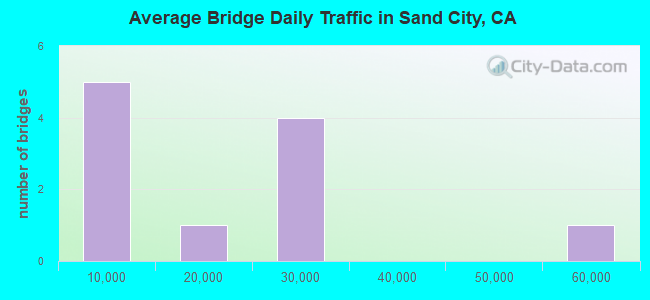
- 11Number of bridges
- 131ft / 39.7mTotal length
- 209,318Total average daily traffic
- 8,449Total average daily truck traffic
- National Bridge Inventory (NBI) Registered Bridges for Sand City
- No street view available for this location
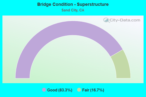
- Bridge Condition - Superstructure
- 83.3%Good
- 16.7%Fair
Find on map >> Show street view
Structure Number: 44 0151, Location: 05-MON-068-R4.04-MON (Lat: 36.594308, Lng: -121.866867), Route carried "on" structure: County highway H187, Year Built: 1967, Status: Open, Structure Length: 7.62m (25.00ft), Average Daily Traffic: 11,118 (year 2008), Truck Traffic: 3%, Average Future Daily Traffic: 14,057 (year 2038), Design Load: HS 20+Mod, Features Intersected: SR 68, N1-E68, W68-N1, Facility Carried by Structure: FAIRGROUND RD
Minimum Vertical Clearance: 30+ m (98+ ft), Kilometerpoint: 0.000, Lanes on structure: 2, Lanes under structure: 5, Owner: State Highway Agency, Approaching Roadway Width: 9.1m (29.9ft), Skew: 9 degrees, Material/Design: Prestressed concrete continuous, Design/Construction: Box Beam or Girders - Multiple, Number Of Spans In Main Unit: 2, Length of Maximum Span: 38.1m (125.0ft), Curb or Sidewalk Widths: Left: 1.5m (4.9ft), Right: 1.5m (4.9ft), Curb-To-Curb Width: 9.8m (32.2ft), Out-to-Out Width: 13.4m (44.0ft)
Condition: Deck: Good, Superstructure: Good, Substructure: Good, Operating Rating: 99.8 metric tons, Method Used To Determine Operating Rating: Load Factor (LF), Inventory Rating: 32.4 metric tons, Method Used To Determine Inventory Rating: Load Factor (LF), Structural Evaluation: Better than present minimum criteria, Deck Geometry: Meets minimum limits, Underclear: Better than present minimum criteria, Approach Roadway Alignment: Equal to present desirable criteria, Designated Inspection Frequency: Every 24 months, Inspection Date: August 2020, Deck Structure Type: Concrete Cast-file-Place
Find on map >> Show street view
Structure Number: 44 0158L, Location: 05-MON-001-R80.67-SNDC (Lat: 36.624183, Lng: -121.842011), Route carried "on" structure: State highway 1, Year Built: 1968, Status: Open, Structure Length: 10.70m (35.10ft), Average Daily Traffic: 29,500 (year 2009), Truck Traffic: 4%, Average Future Daily Traffic: 46,010 (year 2041), Design Load: HS 20+Mod, Features Intersected: S1-OFF, ELLIS RD, PEDS
Minimum Vertical Clearance: 30+ m (98+ ft), Kilometerpoint: 80.670, Lanes on structure: 2, Lanes under structure: 5, Base Highway Network: Yes (, Subroute: 1), Owner: State Highway Agency, Approaching Roadway Width: 11.3m (37.1ft), Skew: 3 degrees, Material/Design: Concrete continuous, Design/Construction: Box Beam or Girders - Multiple, Number Of Spans In Main Unit: 5, Length of Maximum Span: 26.7m (87.6ft), Curb-To-Curb Width: 11.3m (37.1ft), Out-to-Out Width: 11.9m (39.0ft)
Condition: Deck: Good, Superstructure: Good, Substructure: Good, Operating Rating: 40.8 metric tons, Method Used To Determine Operating Rating: Load and Resistance Factor Rating (LRFR) rating reported by rating factor(RF) method using HL-93 loadings, Inventory Rating: 31.4 metric tons, Method Used To Determine Inventory Rating: Load and Resistance Factor Rating (LRFR) rating reported by rating factor(RF) method using HL-93 loadings, Structural Evaluation: Better than present minimum criteria, Deck Geometry: Somewhat better than minimum adequacy, Underclear: Meets minimum limits, Approach Roadway Alignment: Somewhat better than minimum adequacy, Designated Inspection Frequency: Every 24 months, Inspection Date: August 2021, Deck Structure Type: Concrete Cast-file-Place, Wearing Surface/Protective System: Wearing Surface: Integral Concrete
Find on map >> Show street view
Structure Number: 44 0158R, Location: 05-MON-001-R80.67-SNDC (Lat: 36.623933, Lng: -121.842075), Route carried "on" structure: State highway 1, Year Built: 1968, Status: Open, Structure Length: 10.73m (35.20ft), Average Daily Traffic: 29,500 (year 2009), Truck Traffic: 4%, Average Future Daily Traffic: 47,567 (year 2043), Design Load: HS 20, Features Intersected: S1-OFF, ELLIS RD, PEDS
Minimum Vertical Clearance: 30+ m (98+ ft), Kilometerpoint: 80.670, Lanes on structure: 2, Lanes under structure: 5, Base Highway Network: Yes (, Subroute: 1), Owner: State Highway Agency, Approaching Roadway Width: 11.3m (37.1ft), Skew: 3 degrees, Material/Design: Concrete continuous, Design/Construction: Box Beam or Girders - Multiple, Number Of Spans In Main Unit: 5, Length of Maximum Span: 25.2m (82.7ft), Curb-To-Curb Width: 11.3m (37.1ft), Out-to-Out Width: 11.9m (39.0ft)
Condition: Deck: Good, Superstructure: Good, Substructure: Good, Operating Rating: 46.0 metric tons, Method Used To Determine Operating Rating: Load and Resistance Factor Rating (LRFR) rating reported by rating factor(RF) method using HL-93 loadings, Inventory Rating: 33.0 metric tons, Method Used To Determine Inventory Rating: Load and Resistance Factor Rating (LRFR) rating reported by rating factor(RF) method using HL-93 loadings, Structural Evaluation: Better than present minimum criteria, Deck Geometry: Somewhat better than minimum adequacy, Underclear: Meets minimum limits, Approach Roadway Alignment: Somewhat better than minimum adequacy, Designated Inspection Frequency: Every 48 months, Inspection Date: August 2021, Deck Structure Type: Concrete Cast-file-Place, Wearing Surface/Protective System: Wearing Surface: Integral Concrete
Find on map >> Show street view
Structure Number: 44 0165, Location: 05-MON-001-R80.09-SNDC (Lat: 36.617894, Lng: -121.849089), Route carried "on" structure: City street , Year Built: 1968, Status: Open, Structure Length: 4.94m (16.21ft), Average Daily Traffic: 1,200 (year 2005), Truck Traffic: 3%, Average Future Daily Traffic: 1,874 (year 2037), Design Load: HS 20+Mod, Features Intersected: STATE ROUTE 1, Facility Carried by Structure: TIOGA AVE
Minimum Vertical Clearance: 30+ m (98+ ft), Kilometerpoint: 0.000, Lanes on structure: 2, Lanes under structure: 4, Owner: State Highway Agency, Approaching Roadway Width: 9.8m (32.2ft), Material/Design: Concrete continuous, Design/Construction: Box Beam or Girders - Multiple, Number Of Spans In Main Unit: 2, Length of Maximum Span: 25.3m (83.0ft), Curb or Sidewalk Widths: Left: 1.5m (4.9ft), Right: 1.5m (4.9ft), Curb-To-Curb Width: 9.8m (32.2ft), Out-to-Out Width: 13.4m (44.0ft)
Condition: Deck: Good, Superstructure: Good, Substructure: Good, Operating Rating: 58.3 metric tons, Method Used To Determine Operating Rating: Load and Resistance Factor Rating (LRFR) rating reported by rating factor(RF) method using HL-93 loadings, Inventory Rating: 45.0 metric tons, Method Used To Determine Inventory Rating: Load and Resistance Factor Rating (LRFR) rating reported by rating factor(RF) method using HL-93 loadings, Structural Evaluation: Better than present minimum criteria, Deck Geometry: Somewhat better than minimum adequacy, Underclear: High priority of corrective action, Approach Roadway Alignment: Better than present minimum criteria, Designated Inspection Frequency: Every 48 months, Inspection Date: August 2019, Deck Structure Type: Concrete Cast-file-Place
Find on map >> Show street view
Structure Number: 44 0188L, Location: 05-MON-001-R80.27-SNDC (Lat: 36.620042, Lng: -121.847142), Route carried "on" structure: State highway 1, Year Built: 1968, Status: Open, Structure Length: 2.87m (9.42ft), Average Daily Traffic: 29,500 (year 2009), Truck Traffic: 4%, Average Future Daily Traffic: 46,938 (year 2043), Design Load: HS 20+Mod, Features Intersected: PEDESTRIAN WALKWAY
Minimum Vertical Clearance: 30+ m (98+ ft), Kilometerpoint: 80.270, Lanes on structure: 2, Base Highway Network: Yes (, Subroute: 1), Owner: State Highway Agency, Approaching Roadway Width: 11.3m (37.1ft), Skew: 1 degrees, Material/Design: Prestressed concrete, Design/Construction: Box Beam or Girders - Multiple, Number Of Spans In Main Unit: 1, Length of Maximum Span: 27.6m (90.6ft), Curb-To-Curb Width: 11.3m (37.1ft), Out-to-Out Width: 11.9m (39.0ft)
Condition: Deck: Good, Superstructure: Fair, Substructure: Good, Operating Rating: 49.9 metric tons, Method Used To Determine Operating Rating: Load and Resistance Factor Rating (LRFR) rating reported by rating factor(RF) method using HL-93 loadings, Inventory Rating: 32.4 metric tons, Method Used To Determine Inventory Rating: Load and Resistance Factor Rating (LRFR) rating reported by rating factor(RF) method using HL-93 loadings, Structural Evaluation: Somewhat better than minimum adequacy, Deck Geometry: Somewhat better than minimum adequacy, Approach Roadway Alignment: Equal to present desirable criteria, Designated Inspection Frequency: Every 24 months, Inspection Date: August 2021, Deck Structure Type: Concrete Cast-file-Place
Find on map >> Show street view
Structure Number: 44 0188R, Location: 05-MON-001-R80.27-SNDC (Lat: 36.620039, Lng: -121.846867), Route carried "on" structure: State highway 1, Year Built: 1968, Status: Open, Structure Length: 2.87m (9.42ft), Average Daily Traffic: 29,500 (year 2009), Truck Traffic: 4%, Average Future Daily Traffic: 45,100 (year 2037), Design Load: HS 20+Mod, Features Intersected: PEDESTRIAN WALKWAY
Minimum Vertical Clearance: 30+ m (98+ ft), Kilometerpoint: 80.270, Lanes on structure: 2, Base Highway Network: Yes (, Subroute: 1), Owner: State Highway Agency, Approaching Roadway Width: 11.3m (37.1ft), Skew: 1 degrees, Material/Design: Prestressed concrete, Design/Construction: Box Beam or Girders - Multiple, Number Of Spans In Main Unit: 1, Length of Maximum Span: 27.6m (90.6ft), Curb-To-Curb Width: 11.3m (37.1ft), Out-to-Out Width: 11.9m (39.0ft)
Condition: Deck: Good, Superstructure: Good, Substructure: Good, Operating Rating: 49.9 metric tons, Method Used To Determine Operating Rating: Load and Resistance Factor Rating (LRFR) rating reported by rating factor(RF) method using HL-93 loadings, Inventory Rating: 32.4 metric tons, Method Used To Determine Inventory Rating: Load and Resistance Factor Rating (LRFR) rating reported by rating factor(RF) method using HL-93 loadings, Structural Evaluation: Better than present minimum criteria, Deck Geometry: Somewhat better than minimum adequacy, Approach Roadway Alignment: Equal to present desirable criteria, Designated Inspection Frequency: Every 48 months, Inspection Date: August 2019, Deck Structure Type: Concrete Cast-file-Place
Find on map >> Show street view
Structure Number: 44 0158L, Location: 05-MON-001-R80.67-SNDC (Lat: 36.624183, Lng: -121.842011), Route carried "under" structure: Business City street , Year Built: 1968, Structure Length: 0. m, Average Daily Traffic: 5,000 (year 2009), Truck Traffic: 5%, Features Intersected: S1-OFF, ELLIS RD, PEDS, Facility Carried by Structure: STATE ROUTE 1 SB
Minimum Vertical Clearance: 6.01m (19.72ft), Kilometerpoint: 0.000, Lanes on structure: 2, Lanes under structure: 2, Material/Design: Concrete continuous, Design/Construction: Box Beam or Girders - Multiple, Length of Maximum Span: 26.7m (87.6ft)
Find on map >> Show street view
Structure Number: 44 0158L, Location: 05-MON-001-R80.67-SNDC (Lat: 36.624183, Lng: -121.842011), Route carried "under" structure: Business City street , Year Built: 1968, Structure Length: 0. m, Average Daily Traffic: 5,000 (year 2009), Truck Traffic: 5%, Features Intersected: S1-OFF, ELLIS RD, PEDS, Facility Carried by Structure: STATE ROUTE 1 SB
Minimum Vertical Clearance: 5.63m (18.47ft), Kilometerpoint: 0.000, Lanes on structure: 2, Lanes under structure: 3, Material/Design: Concrete continuous, Design/Construction: Box Beam or Girders - Multiple, Length of Maximum Span: 26.7m (87.6ft)
Find on map >> Show street view
Structure Number: 44 0158R, Location: 05-MON-001-R80.67-SNDC (Lat: 36.623933, Lng: -121.842075), Route carried "under" structure: Business City street , Year Built: 1968, Structure Length: 0. m, Average Daily Traffic: 5,000 (year 2009), Truck Traffic: 5%, Features Intersected: S1-OFF, ELLIS RD, PEDS, Facility Carried by Structure: STATE ROUTE 1 NB
Minimum Vertical Clearance: 8.02m (26.31ft), Kilometerpoint: 0.000, Lanes on structure: 2, Lanes under structure: 2, Material/Design: Concrete continuous, Design/Construction: Box Beam or Girders - Multiple, Length of Maximum Span: 25.2m (82.7ft)
Find on map >> Show street view
Structure Number: 44 0158R, Location: 05-MON-001-R80.67-SNDC (Lat: 36.623933, Lng: -121.842075), Route carried "under" structure: Ramp City street , Year Built: 1968, Structure Length: 0. m, Average Daily Traffic: 5,000 (year 2009), Truck Traffic: 5%, Features Intersected: S1-OFF, ELLIS RD, PEDS, Facility Carried by Structure: STATE ROUTE 1 NB
Minimum Vertical Clearance: 7.59m (24.90ft), Kilometerpoint: 0.000, Lanes on structure: 2, Lanes under structure: 3, Material/Design: Concrete continuous, Design/Construction: Box Beam or Girders - Multiple, Length of Maximum Span: 25.2m (82.7ft)
Find on map >> Show street view
Structure Number: 44 0165, Location: 05-MON-001-R80.09-SNDC (Lat: 36.617894, Lng: -121.849089), Route carried "under" structure: State highway 1, Year Built: 1968, Structure Length: 0. m, Average Daily Traffic: 59,000 (year 2009), Truck Traffic: 4%, Features Intersected: STATE ROUTE 1, Facility Carried by Structure: TIOGA AVE
Minimum Vertical Clearance: 4.80m (15.75ft), Kilometerpoint: 80.090, Lanes on structure: 2, Lanes under structure: 4, Material/Design: Concrete continuous, Design/Construction: Box Beam or Girders - Multiple, Length of Maximum Span: 25.3m (83.0ft)