Bridge Statistics for Sayre, Oklahoma (OK)
Condition, Traffic, Stress, Structural Evaluation, Project Costs
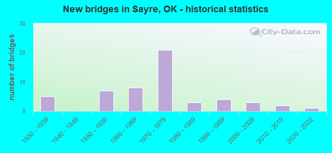
- New bridges - historical statistics
- 51930-1939
- 71950-1959
- 81960-1969
- 211970-1979
- 31980-1989
- 41990-1999
- 32000-2009
- 22010-2019
- 12020-2022
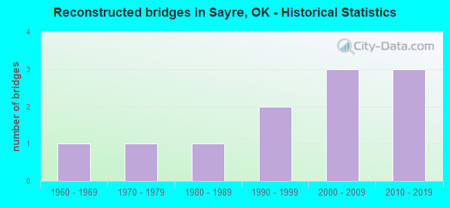
- Reconstructed bridges - Historical Statistics
- 11960-1969
- 11970-1979
- 11980-1989
- 21990-1999
- 32000-2009
- 32010-2019
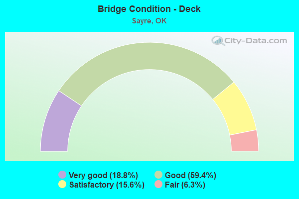
- Bridge Condition - Deck
- 18.8%Very good
- 59.4%Good
- 15.6%Satisfactory
- 6.3%Fair
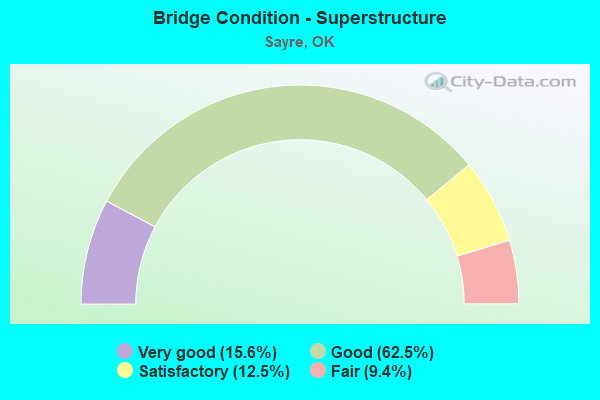
- Bridge Condition - Superstructure
- 15.6%Very good
- 62.5%Good
- 12.5%Satisfactory
- 9.4%Fair
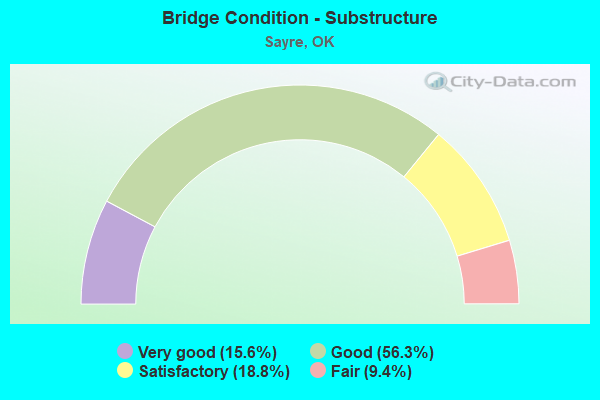
- Bridge Condition - Substructure
- 15.6%Very good
- 56.3%Good
- 18.8%Satisfactory
- 9.4%Fair
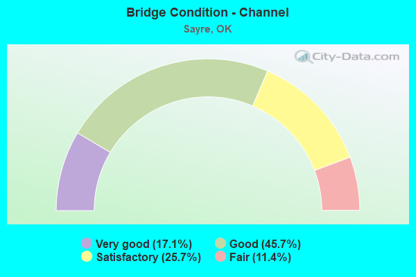
- Bridge Condition - Channel
- 17.1%Very good
- 45.7%Good
- 25.7%Satisfactory
- 11.4%Fair
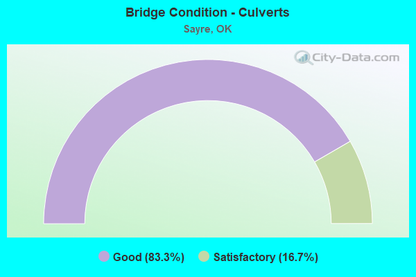
- Bridge Condition - Culverts
- 83.3%Good
- 16.7%Satisfactory
Find on map >> Show street view
Structure Number: 2863, Location: 4.2 MI N JCT I-40 BUS. (Lat: 35.367989, Lng: -99.637792), Route carried "on" structure: US 283, Year Built: 1930, Status: Open, Structure Length: 0.91m (2.99ft), Average Daily Traffic: 930 (year 2020), Truck Traffic: 16%, Average Future Daily Traffic: 1,488 (year 2040), Design Load: H 20, Features Intersected: CREEK
Minimum Vertical Clearance: 30+ m (98+ ft), Kilometerpoint: 10.902, Lanes on structure: 2, Base Highway Network: Yes, Owner: State Highway Agency, Approaching Roadway Width: 7.9m (25.9ft), Material/Design: Concrete, Design/Construction: Culvert, Number Of Spans In Main Unit: 2, Length of Maximum Span: 3.0m (9.8ft), Curb-To-Curb Width: 9.1m (29.9ft), Out-to-Out Width: 9.8m (32.2ft)
Condition: Channel: Very good, Culverts: Satisfactory, Operating Rating: 55.8 metric tons, Method Used To Determine Operating Rating: Load Factor (LF), Inventory Rating: 33.5 metric tons, Method Used To Determine Inventory Rating: Load Factor (LF), Structural Evaluation: Equal to present minimum criteria, Deck Geometry: Equal to present minimum criteria, Waterway Adequacy: Better than present minimum criteria, Approach Roadway Alignment: Equal to present desirable criteria, Length Of Structure Improvement: 0.91m (2.99ft), Designated Inspection Frequency: Every 24 months, Inspection Date: January 2021, Bridge Improvement Cost: $230,000, Roadway Improvement Cost: $380,000, Total Project Cost: $644,000 ( Estimate for 2015)
Find on map >> Show street view
Structure Number: 3495, Location: 1.7 MI N JACKSON C/L (Lat: 34.524103, Lng: -99.771464), Route carried "on" structure: State highway 5, Year Built: 1932, Status: Open, Structure Length: 0.67m (2.20ft), Average Daily Traffic: 250 (year 2020), Truck Traffic: 15%, Average Future Daily Traffic: 400 (year 2040), Design Load: H 20, Features Intersected: CREEK
Minimum Vertical Clearance: 30+ m (98+ ft), Kilometerpoint: 2.589, Lanes on structure: 2, Owner: State Highway Agency, Approaching Roadway Width: 8.2m (26.9ft), Material/Design: Concrete, Design/Construction: Culvert, Number Of Spans In Main Unit: 2, Length of Maximum Span: 3.0m (9.8ft), Curb-To-Curb Width: 9.1m (29.9ft), Out-to-Out Width: 9.8m (32.2ft)
Condition: Channel: Good, Culverts: Good, Operating Rating: 55.7 metric tons, Method Used To Determine Operating Rating: Load Factor (LF), Inventory Rating: 33.4 metric tons, Method Used To Determine Inventory Rating: Load Factor (LF), Structural Evaluation: Better than present minimum criteria, Deck Geometry: Equal to present minimum criteria, Waterway Adequacy: Better than present minimum criteria, Approach Roadway Alignment: Equal to present desirable criteria, Length Of Structure Improvement: 0.67m (2.20ft), Designated Inspection Frequency: Every 24 months, Inspection Date: October 2021, Bridge Improvement Cost: $230,000, Roadway Improvement Cost: $380,000, Total Project Cost: $644,000 ( Estimate for 2015)
Find on map >> Show street view
Structure Number: 3636, Location: 2.1 MI N JCT SH32 (Lat: 34.052217, Lng: -97.959053), Route carried "on" structure: US 81, Year Built: 1932, Year Reconstructed: 1965, Status: Open, Structure Length: 1.01m (3.31ft), Average Daily Traffic: 2,000 (year 2020), Truck Traffic: 25%, Average Future Daily Traffic: 3,200 (year 2040), Design Load: H 20, Features Intersected: CREEK
Minimum Vertical Clearance: 30+ m (98+ ft), Kilometerpoint: 20.434, Lanes on structure: 2, Base Highway Network: Yes, Owner: State Highway Agency, Approaching Roadway Width: 13.4m (44.0ft), Material/Design: Concrete, Design/Construction: Culvert, Number Of Spans In Main Unit: 3, Length of Maximum Span: 3.0m (9.8ft)
Condition: Channel: Very good, Culverts: Good, Inventory Rating: 58.1 metric tons, Method Used To Determine Inventory Rating: Load Factor (LF), Structural Evaluation: Better than present minimum criteria, Waterway Adequacy: Equal to present desirable criteria, Approach Roadway Alignment: Equal to present desirable criteria, Length Of Structure Improvement: 1.01m (3.31ft), Designated Inspection Frequency: Every 24 months, Inspection Date: April 2020, Bridge Improvement Cost: $230,000, Roadway Improvement Cost: $380,000, Total Project Cost: $644,000 ( Estimate for 2015)
Find on map >> Show street view
Structure Number: 4671, Location: 1.2 W OF US 283 (Lat: 35.349169, Lng: -99.658867), Route carried "on" structure: County highway E1150, Year Built: 1936, Status: Open, Structure Length: 0.73m (2.40ft), Average Daily Traffic: 50 (year 2020), Truck Traffic: 15%, Average Future Daily Traffic: 80 (year 2040), Features Intersected: SHORT CREEK
Minimum Vertical Clearance: 30+ m (98+ ft), Kilometerpoint: 5.309, Lanes on structure: 2, Owner: County Highway Agency, Approaching Roadway Width: 6.7m (22.0ft), Material/Design: Concrete continuous, Design/Construction: Slab, Number Of Spans In Main Unit: 2, Length of Maximum Span: 3.0m (9.8ft), Curb-To-Curb Width: 10.4m (34.1ft), Out-to-Out Width: 11.0m (36.1ft)
Condition: Deck: Satisfactory, Superstructure: Satisfactory, Substructure: Satisfactory, Channel: Satisfactory, Operating Rating: 32.7 metric tons, Method Used To Determine Operating Rating: Load Factor (LF), Inventory Rating: 19.1 metric tons, Method Used To Determine Inventory Rating: Load Factor (LF), Structural Evaluation: Somewhat better than minimum adequacy, Deck Geometry: Superior to present desirable criteria, Waterway Adequacy: Equal to present minimum criteria, Approach Roadway Alignment: Equal to present desirable criteria, Length Of Structure Improvement: 2.92m (9.58ft), Designated Inspection Frequency: Every 24 months, Inspection Date: April 2020, Bridge Improvement Cost: $149,000, Roadway Improvement Cost: $82,000, Total Project Cost: $236,000 ( Estimate for 2015), Deck Structure Type: Concrete Cast-file-Place, Wearing Surface/Protective System: Wearing Surface: Bituminous
Find on map >> Show street view
Structure Number: 5614, Location: 3.5 E 4.3 N OF SAYRE (Lat: 35.352686, Lng: -99.576089), Route carried "on" structure: County highway N1910, Year Built: 1938, Status: Open, Structure Length: 0.73m (2.40ft), Average Daily Traffic: 25 (year 2020), Truck Traffic: 10%, Average Future Daily Traffic: 40 (year 2040), Features Intersected: CREEK
Minimum Vertical Clearance: 30+ m (98+ ft), Kilometerpoint: 1.127, Lanes on structure: 2, Owner: County Highway Agency, Approaching Roadway Width: 7.3m (24.0ft), Material/Design: Concrete continuous, Design/Construction: Slab, Number Of Spans In Main Unit: 2, Length of Maximum Span: 3.0m (9.8ft), Curb-To-Curb Width: 9.2m (30.2ft), Out-to-Out Width: 9.8m (32.2ft)
Condition: Deck: Good, Superstructure: Good, Substructure: Good, Channel: Satisfactory, Operating Rating: 37.2 metric tons, Method Used To Determine Operating Rating: Load Factor (LF), Inventory Rating: 27.2 metric tons, Method Used To Determine Inventory Rating: Load Factor (LF), Structural Evaluation: Equal to present minimum criteria, Deck Geometry: Better than present minimum criteria, Waterway Adequacy: Equal to present minimum criteria, Approach Roadway Alignment: Equal to present desirable criteria, Length Of Structure Improvement: 2.92m (9.58ft), Designated Inspection Frequency: Every 24 months, Inspection Date: April 2020, Bridge Improvement Cost: $149,000, Roadway Improvement Cost: $82,000, Total Project Cost: $236,000 ( Estimate for 2015), Deck Structure Type: Concrete Cast-file-Place, Wearing Surface/Protective System: Wearing Surface: Bituminous
Find on map >> Show street view
Structure Number: 13986, Location: 0.1 MI W JCT I-40 (Lat: 35.314972, Lng: -99.614775), Route carried "on" structure: Business State highway 40B, Year Built: 1958, Status: Open, Structure Length: 0.70m (2.30ft), Average Daily Traffic: 1,350 (year 2020), Truck Traffic: 15%, Average Future Daily Traffic: 2,160 (year 2040), Design Load: HS 20, Features Intersected: CREEK, Facility Carried by Structure: I-40 BUS.
Minimum Vertical Clearance: 30+ m (98+ ft), Kilometerpoint: 7.450, Lanes on structure: 2, Owner: State Highway Agency, Approaching Roadway Width: 14.6m (47.9ft), Material/Design: Concrete, Design/Construction: Culvert, Number Of Spans In Main Unit: 2, Length of Maximum Span: 3.0m (9.8ft), Curb-To-Curb Width: 29.9m (98.1ft), Out-to-Out Width: 30.5m (100.1ft)
Condition: Channel: Good, Culverts: Good, Operating Rating: 90.7 metric tons, Method Used To Determine Operating Rating: Load Factor (LF), Inventory Rating: 90.7 metric tons, Method Used To Determine Inventory Rating: Load Factor (LF), Structural Evaluation: Better than present minimum criteria, Deck Geometry: Superior to present desirable criteria, Waterway Adequacy: Equal to present minimum criteria, Approach Roadway Alignment: Better than present minimum criteria, Length Of Structure Improvement: 0.70m (2.30ft), Designated Inspection Frequency: Every 24 months, Inspection Date: March 2021, Bridge Improvement Cost: $230,000, Roadway Improvement Cost: $380,000, Total Project Cost: $644,000 ( Estimate for 2015)
Find on map >> Show street view
Structure Number: 13987, Location: 0.1 MI W JCT I-40 (Lat: 35.315597, Lng: -99.615100), Route carried "on" structure: Business State highway 40B, Year Built: 1958, Status: Open, Structure Length: 0.70m (2.30ft), Average Daily Traffic: 1,350 (year 2020), Truck Traffic: 15%, Average Future Daily Traffic: 2,160 (year 2040), Design Load: HS 20, Features Intersected: CREEK, Facility Carried by Structure: I-40 N Frontage Rd
Minimum Vertical Clearance: 30+ m (98+ ft), Kilometerpoint: 7.450, Lanes on structure: 2, Owner: State Highway Agency, Approaching Roadway Width: 7.9m (25.9ft), Material/Design: Concrete, Design/Construction: Culvert, Number Of Spans In Main Unit: 2, Length of Maximum Span: 3.0m (9.8ft), Curb-To-Curb Width: 27.4m (89.9ft), Out-to-Out Width: 28.0m (91.9ft)
Condition: Channel: Satisfactory, Culverts: Good, Operating Rating: 90.7 metric tons, Method Used To Determine Operating Rating: Load Factor (LF), Inventory Rating: 75.9 metric tons, Method Used To Determine Inventory Rating: Load Factor (LF), Structural Evaluation: Better than present minimum criteria, Deck Geometry: Superior to present desirable criteria, Waterway Adequacy: Equal to present minimum criteria, Approach Roadway Alignment: Better than present minimum criteria, Length Of Structure Improvement: 0.70m (2.30ft), Designated Inspection Frequency: Every 24 months, Inspection Date: March 2021, Bridge Improvement Cost: $230,000, Roadway Improvement Cost: $380,000, Total Project Cost: $644,000 ( Estimate for 2015)
Find on map >> Show street view
Structure Number: 14021, Location: 0.1 MI E I-40 BUS. (Lat: 35.316631, Lng: -99.611053), Route carried "on" structure: Interstate 40, Year Built: 1958, Year Reconstructed: 1970, Status: Open, Structure Length: 1.07m (3.51ft), Average Daily Traffic: 15,700 (year 2020), Truck Traffic: 40%, Average Future Daily Traffic: 25,120 (year 2040), Design Load: HS 20, Features Intersected: DEEP CREEK
Minimum Vertical Clearance: 30+ m (98+ ft), Kilometerpoint: 0.129, Lanes on structure: 4, Base Highway Network: Yes, Owner: State Highway Agency, Approaching Roadway Width: 23.2m (76.1ft), Skew: 3 degrees, Material/Design: Concrete, Design/Construction: Culvert, Number Of Spans In Main Unit: 3, Length of Maximum Span: 3.0m (9.8ft)
Condition: Channel: Satisfactory, Culverts: Good, Operating Rating: 80.0 metric tons, Method Used To Determine Operating Rating: Load Factor (LF), Inventory Rating: 48.0 metric tons, Method Used To Determine Inventory Rating: Load Factor (LF), Structural Evaluation: Better than present minimum criteria, Waterway Adequacy: Equal to present desirable criteria, Approach Roadway Alignment: Equal to present desirable criteria, Length Of Structure Improvement: 1.07m (3.51ft), Designated Inspection Frequency: Every 24 months, Inspection Date: March 2021, Bridge Improvement Cost: $807,000, Roadway Improvement Cost: $1,332,000, Total Project Cost: $2,261,000 ( Estimate for 2015)
Find on map >> Show street view
Structure Number: 14091, Location: 1.8 MI. N. JCT. U.S. 283 (Lat: 35.287836, Lng: -99.639817), Route carried "on" structure: Business State highway 40B, Year Built: 1958, Status: Open, Structure Length: 2.29m (7.51ft), Average Daily Traffic: 2,700 (year 2020), Truck Traffic: 15%, Average Future Daily Traffic: 4,320 (year 2040), Design Load: HS 20, Features Intersected: SHORT CREEK, Facility Carried by Structure: I-40 BUS.
Minimum Vertical Clearance: 30+ m (98+ ft), Kilometerpoint: 4.609, Lanes on structure: 4, Owner: State Highway Agency, Approaching Roadway Width: 19.5m (64.0ft), Skew: 23 degrees, Material/Design: Concrete, Design/Construction: Culvert, Number Of Spans In Main Unit: 4, Length of Maximum Span: 5.2m (17.1ft), Curb-To-Curb Width: 25.3m (83.0ft), Out-to-Out Width: 25.9m (85.0ft)
Condition: Channel: Good, Culverts: Good, Operating Rating: 34.9 metric tons, Method Used To Determine Operating Rating: Load Factor (LF), Inventory Rating: 20.9 metric tons, Method Used To Determine Inventory Rating: Load Factor (LF), Structural Evaluation: Somewhat better than minimum adequacy, Deck Geometry: Superior to present desirable criteria, Waterway Adequacy: Better than present minimum criteria, Approach Roadway Alignment: Better than present minimum criteria, Length Of Structure Improvement: 2.29m (7.51ft), Designated Inspection Frequency: Every 24 months, Inspection Date: March 2021, Bridge Improvement Cost: $426,000, Roadway Improvement Cost: $704,000, Total Project Cost: $1,194,000 ( Estimate for 2015)
Find on map >> Show street view
Structure Number: 14139, Location: 12.6 MI E S.H. 30 (Lat: 35.262203, Lng: -99.658022), Route carried "on" structure: ServiceUS 40, Year Built: 1958, Status: Open, Structure Length: 4.63m (15.19ft), Average Daily Traffic: 100 (year 2020), Truck Traffic: 16%, Average Future Daily Traffic: 160 (year 2040), Design Load: HS 20, Features Intersected: SAND CREEK
Minimum Vertical Clearance: 30+ m (98+ ft), Kilometerpoint: 32.148, Lanes on structure: 2, Base Highway Network: Yes, Owner: State Highway Agency, Approaching Roadway Width: 7.3m (24.0ft), Skew: 3 degrees, Material/Design: Steel, Design/Construction: Stringer/Multi-beam, Number Of Spans In Main Unit: 3, Length of Maximum Span: 15.2m (49.9ft), Curb-To-Curb Width: 8.5m (27.9ft), Out-to-Out Width: 9.4m (30.8ft)
Condition: Deck: Satisfactory, Superstructure: Good, Substructure: Satisfactory, Channel: Good, Operating Rating: 59.0 metric tons, Method Used To Determine Operating Rating: Load Factor (LF), Inventory Rating: 35.4 metric tons, Method Used To Determine Inventory Rating: Load Factor (LF), Structural Evaluation: Equal to present minimum criteria, Deck Geometry: Better than present minimum criteria, Waterway Adequacy: Better than present minimum criteria, Approach Roadway Alignment: Better than present minimum criteria, Length Of Structure Improvement: 7.77m (25.49ft), Designated Inspection Frequency: Every 24 months, Inspection Date: March 2021, Bridge Improvement Cost: $644,000, Roadway Improvement Cost: $1,063,000, Total Project Cost: $1,805,000 ( Estimate for 2015), Deck Structure Type: Concrete Cast-file-Place, Wearing Surface/Protective System: Wearing Surface: Bituminous
Find on map >> Show street view
Structure Number: 14169, Location: 2.8 MI E I-40 BUS. (Lat: 35.345133, Lng: -99.581192), Route carried "on" structure: Interstate 40, Year Built: 1958, Year Reconstructed: 1988, Status: Open, Structure Length: 6.37m (20.90ft), Average Daily Traffic: 7,650 (year 2020), Truck Traffic: 40%, Average Future Daily Traffic: 12,240 (year 2040), Design Load: HS 20, Features Intersected: TIMBER CREEK
Minimum Vertical Clearance: 30+ m (98+ ft), Kilometerpoint: 4.394, Lanes on structure: 2, Base Highway Network: Yes, Owner: State Highway Agency, Approaching Roadway Width: 11.6m (38.1ft), Skew: 10 degrees, Material/Design: Steel continuous, Design/Construction: Stringer/Multi-beam, Number Of Spans In Main Unit: 3, Length of Maximum Span: 24.4m (80.1ft), Curb-To-Curb Width: 11.6m (38.1ft), Out-to-Out Width: 12.5m (41.0ft)
Condition: Deck: Good, Superstructure: Good, Substructure: Good, Channel: Good, Operating Rating: 55.3 metric tons, Method Used To Determine Operating Rating: Load Factor (LF), Inventory Rating: 32.7 metric tons, Method Used To Determine Inventory Rating: Load Factor (LF), Structural Evaluation: Better than present minimum criteria, Deck Geometry: Equal to present minimum criteria, Waterway Adequacy: Better than present minimum criteria, Approach Roadway Alignment: Equal to present desirable criteria, Length Of Structure Improvement: 9.21m (30.22ft), Designated Inspection Frequency: Every 24 months, Inspection Date: March 2021, Bridge Improvement Cost: $745,000, Roadway Improvement Cost: $1,230,000, Total Project Cost: $2,087,000 ( Estimate for 2015), Deck Structure Type: Concrete Cast-file-Place, Wearing Surface/Protective System: Wearing Surface: Epoxy Overlay, Deck Protection: Epoxy Coated Reinforcing
Find on map >> Show street view
Structure Number: 1417, Location: 2.8 MI E I-40 BUS. (Lat: 35.344883, Lng: -99.580986), Route carried "on" structure: Interstate 40, Year Built: 1958, Year Reconstructed: 2010, Status: Open, Structure Length: 6.37m (20.90ft), Average Daily Traffic: 7,850 (year 2020), Truck Traffic: 40%, Average Future Daily Traffic: 12,560 (year 2040), Design Load: HS 20, Features Intersected: TIMBER CREEK
Minimum Vertical Clearance: 30+ m (98+ ft), Kilometerpoint: 4.394, Lanes on structure: 2, Base Highway Network: Yes, Owner: State Highway Agency, Approaching Roadway Width: 11.6m (38.1ft), Skew: 10 degrees, Material/Design: Steel continuous, Design/Construction: Stringer/Multi-beam, Number Of Spans In Main Unit: 3, Length of Maximum Span: 24.4m (80.1ft), Curb-To-Curb Width: 11.6m (38.1ft), Out-to-Out Width: 12.5m (41.0ft)
Condition: Deck: Good, Superstructure: Good, Substructure: Good, Channel: Good, Operating Rating: 47.2 metric tons, Method Used To Determine Operating Rating: Load Factor (LF), Inventory Rating: 28.1 metric tons, Method Used To Determine Inventory Rating: Load Factor (LF), Structural Evaluation: Better than present minimum criteria, Deck Geometry: Equal to present minimum criteria, Waterway Adequacy: Better than present minimum criteria, Approach Roadway Alignment: Equal to present desirable criteria, Length Of Structure Improvement: 9.21m (30.22ft), Designated Inspection Frequency: Every 24 months, Inspection Date: March 2021, Bridge Improvement Cost: $745,000, Roadway Improvement Cost: $1,230,000, Total Project Cost: $2,087,000 ( Estimate for 2015), Deck Structure Type: Concrete Cast-file-Place, Wearing Surface/Protective System: Wearing Surface: Monolithic Concrete, Deck Protection: Epoxy Coated Reinforcing
Find on map >> Show street view
Structure Number: 14902, Location: 6. N 3.4 E OF SAYRE (Lat: 35.378153, Lng: -99.578042), Route carried "on" structure: County highway E1130, Year Built: 1960, Year Reconstructed: 2001, Status: Open, Structure Length: 1.28m (4.20ft), Average Daily Traffic: 25 (year 2020), Truck Traffic: 10%, Average Future Daily Traffic: 40 (year 2040), Features Intersected: CREEK
Minimum Vertical Clearance: 30+ m (98+ ft), Kilometerpoint: 1.448, Lanes on structure: 2, Owner: County Highway Agency, Approaching Roadway Width: 7.3m (24.0ft), Skew: 3 degrees, Material/Design: Steel continuous, Design/Construction: Stringer/Multi-beam, Number Of Spans In Main Unit: 2, Length of Maximum Span: 6.1m (20.0ft), Curb-To-Curb Width: 7.8m (25.6ft), Out-to-Out Width: 7.9m (25.9ft)
Condition: Deck: Good, Superstructure: Satisfactory, Substructure: Satisfactory, Channel: Good, Inventory Rating: 63.5 metric tons, Method Used To Determine Inventory Rating: Load Factor (LF), Structural Evaluation: Equal to present minimum criteria, Deck Geometry: Equal to present minimum criteria, Waterway Adequacy: Equal to present minimum criteria, Approach Roadway Alignment: Equal to present desirable criteria, Length Of Structure Improvement: 3.88m (12.73ft), Designated Inspection Frequency: Every 24 months, Inspection Date: April 2020, Bridge Improvement Cost: $198,000, Roadway Improvement Cost: $109,000, Total Project Cost: $315,000 ( Estimate for 2015), Deck Structure Type: Concrete Cast-file-Place, Wearing Surface/Protective System: Wearing Surface: Bituminous
Find on map >> Show street view
Structure Number: 15827, Location: 14.6 MI SE JCT S.H. 6 (Lat: 35.291208, Lng: -99.667392), Route carried "on" structure: State highway 152, Year Built: 1963, Year Reconstructed: 2010, Status: Open, Structure Length: 6.40m (21.00ft), Average Daily Traffic: 1,200 (year 2020), Truck Traffic: 15%, Average Future Daily Traffic: 1,920 (year 2040), Design Load: HS 20, Features Intersected: LONG CREEK
Minimum Vertical Clearance: 30+ m (98+ ft), Kilometerpoint: 23.620, Lanes on structure: 2, Owner: State Highway Agency, Approaching Roadway Width: 11.9m (39.0ft), Material/Design: Steel continuous, Design/Construction: Stringer/Multi-beam, Number Of Spans In Main Unit: 3, Length of Maximum Span: 24.4m (80.1ft), Curb-To-Curb Width: 9.1m (29.9ft), Out-to-Out Width: 9.8m (32.2ft)
Condition: Deck: Good, Superstructure: Good, Substructure: Good, Channel: Good, Operating Rating: 62.6 metric tons, Method Used To Determine Operating Rating: Load Factor (LF), Inventory Rating: 37.2 metric tons, Method Used To Determine Inventory Rating: Load Factor (LF), Structural Evaluation: Better than present minimum criteria, Deck Geometry: Somewhat better than minimum adequacy, Waterway Adequacy: Equal to present desirable criteria, Approach Roadway Alignment: Better than present minimum criteria, Length Of Structure Improvement: 9.23m (30.28ft), Designated Inspection Frequency: Every 24 months, Inspection Date: January 2021, Bridge Improvement Cost: $747,000, Roadway Improvement Cost: $1,232,000, Total Project Cost: $2,092,000 ( Estimate for 2015), Deck Structure Type: Concrete Cast-file-Place, Wearing Surface/Protective System: Wearing Surface: Monolithic Concrete, Deck Protection: Epoxy Coated Reinforcing
Find on map >> Show street view
Structure Number: 16445, Location: 0.5 MI W JCT U.S. 283 (Lat: 35.291183, Lng: -99.645567), Route carried "on" structure: State highway 152, Year Built: 1965, Status: Open, Structure Length: 1.98m (6.50ft), Average Daily Traffic: 1,500 (year 2020), Truck Traffic: 15%, Average Future Daily Traffic: 2,400 (year 2040), Design Load: HS 20, Features Intersected: SHORT CREEK
Minimum Vertical Clearance: 30+ m (98+ ft), Kilometerpoint: 25.598, Lanes on structure: 2, Owner: State Highway Agency, Approaching Roadway Width: 11.9m (39.0ft), Material/Design: Concrete, Design/Construction: Culvert, Number Of Spans In Main Unit: 4, Length of Maximum Span: 5.2m (17.1ft), Curb-To-Curb Width: 12.2m (40.0ft), Out-to-Out Width: 12.8m (42.0ft)
Condition: Channel: Good, Culverts: Good, Operating Rating: 57.8 metric tons, Method Used To Determine Operating Rating: Load Factor (LF), Inventory Rating: 34.6 metric tons, Method Used To Determine Inventory Rating: Load Factor (LF), Structural Evaluation: Better than present minimum criteria, Deck Geometry: Better than present minimum criteria, Waterway Adequacy: Equal to present minimum criteria, Approach Roadway Alignment: Better than present minimum criteria, Length Of Structure Improvement: 1.98m (6.50ft), Designated Inspection Frequency: Every 24 months, Inspection Date: January 2021, Bridge Improvement Cost: $313,000, Roadway Improvement Cost: $517,000, Total Project Cost: $878,000 ( Estimate for 2015)
Find on map >> Show street view
Structure Number: 16933, Location: 1.9 N OF I40 (Lat: 35.367981, Lng: -99.593692), Route carried "on" structure: County highway N1900, Year Built: 1967, Status: Open, Structure Length: 2.80m (9.19ft), Average Daily Traffic: 100 (year 2020), Truck Traffic: 15%, Average Future Daily Traffic: 160 (year 2040), Features Intersected: TIMBER CREEK
Minimum Vertical Clearance: 30+ m (98+ ft), Kilometerpoint: 3.058, Lanes on structure: 2, Owner: County Highway Agency, Approaching Roadway Width: 7.9m (25.9ft), Material/Design: Concrete, Design/Construction: Stringer/Multi-beam, Number Of Spans In Main Unit: 3, Length of Maximum Span: 9.1m (29.9ft), Curb-To-Curb Width: 8.2m (26.9ft), Out-to-Out Width: 8.7m (28.5ft)
Condition: Deck: Good, Superstructure: Good, Substructure: Good, Channel: Fair, Operating Rating: 44.5 metric tons, Method Used To Determine Operating Rating: Load Factor (LF), Inventory Rating: 32.7 metric tons, Method Used To Determine Inventory Rating: Load Factor (LF), Structural Evaluation: Better than present minimum criteria, Deck Geometry: Equal to present minimum criteria, Waterway Adequacy: Equal to present minimum criteria, Approach Roadway Alignment: Equal to present desirable criteria, Length Of Structure Improvement: 5.96m (19.55ft), Designated Inspection Frequency: Every 24 months, Inspection Date: April 2020, Bridge Improvement Cost: $304,000, Roadway Improvement Cost: $167,000, Total Project Cost: $486,000 ( Estimate for 2015), Deck Structure Type: Concrete Cast-file-Place, Wearing Surface/Protective System: Wearing Surface: Bituminous
Find on map >> Show street view
Structure Number: 17497, Location: 12.6 MI E S.H. 30 (Lat: 35.262086, Lng: -99.658097), Route carried "on" structure: Interstate 40, Year Built: 1969, Year Reconstructed: 2009, Status: Open, Structure Length: 4.60m (15.09ft), Average Daily Traffic: 6,500 (year 2020), Truck Traffic: 53%, Average Future Daily Traffic: 10,400 (year 2040), Design Load: HS 20, Features Intersected: SAND CREEK
Minimum Vertical Clearance: 30+ m (98+ ft), Kilometerpoint: 32.148, Lanes on structure: 2, Base Highway Network: Yes, Owner: State Highway Agency, Approaching Roadway Width: 11.6m (38.1ft), Skew: 13 degrees, Material/Design: Steel, Design/Construction: Stringer/Multi-beam, Number Of Spans In Main Unit: 3, Length of Maximum Span: 15.2m (49.9ft), Curb-To-Curb Width: 11.6m (38.1ft), Out-to-Out Width: 12.2m (40.0ft)
Condition: Deck: Good, Superstructure: Satisfactory, Substructure: Satisfactory, Channel: Good, Operating Rating: 60.8 metric tons, Method Used To Determine Operating Rating: Load Factor (LF), Inventory Rating: 36.3 metric tons, Method Used To Determine Inventory Rating: Load Factor (LF), Structural Evaluation: Equal to present minimum criteria, Deck Geometry: Equal to present minimum criteria, Waterway Adequacy: Better than present minimum criteria, Approach Roadway Alignment: Better than present minimum criteria, Length Of Structure Improvement: 7.75m (25.43ft), Designated Inspection Frequency: Every 24 months, Inspection Date: March 2021, Bridge Improvement Cost: $643,000, Roadway Improvement Cost: $1,060,000, Total Project Cost: $1,799,000 ( Estimate for 2015), Deck Structure Type: Concrete Cast-file-Place, Wearing Surface/Protective System: Wearing Surface: Monolithic Concrete, Deck Protection: Epoxy Coated Reinforcing
Find on map >> Show street view
Structure Number: 17564, Location: 11.2 MI E S.H. 30 (Lat: 35.261708, Lng: -99.682181), Route carried "on" structure: County highway N1850, Year Built: 1969, Status: Open, Structure Length: 8.26m (27.10ft), Average Daily Traffic: 50 (year 2020), Truck Traffic: 15%, Average Future Daily Traffic: 80 (year 2040), Design Load: H 15, Features Intersected: I-40 UNDER, Facility Carried by Structure: NS-185 CO. RD.
Minimum Vertical Clearance: 30+ m (98+ ft), Kilometerpoint: 29.992, Lanes on structure: 2, Lanes under structure: 6, Owner: State Highway Agency, Approaching Roadway Width: 8.2m (26.9ft), Material/Design: Steel continuous, Design/Construction: Stringer/Multi-beam, Number Of Spans In Main Unit: 4, Length of Maximum Span: 24.4m (80.1ft), Curb-To-Curb Width: 8.5m (27.9ft), Out-to-Out Width: 8.8m (28.9ft)
Condition: Deck: Good, Superstructure: Good, Substructure: Good, Operating Rating: 36.3 metric tons, Method Used To Determine Operating Rating: Load Factor (LF), Inventory Rating: 21.8 metric tons, Method Used To Determine Inventory Rating: Load Factor (LF), Structural Evaluation: Equal to present minimum criteria, Deck Geometry: Better than present minimum criteria, Underclear: High priority of replacement, Approach Roadway Alignment: Equal to present minimum criteria, Length Of Structure Improvement: 8.40m (27.56ft), Designated Inspection Frequency: Every 24 months, Inspection Date: March 2021, Bridge Improvement Cost: $689,000, Roadway Improvement Cost: $1,137,000, Total Project Cost: $1,929,000 ( Estimate for 2015), Deck Structure Type: Concrete Cast-file-Place
Find on map >> Show street view
Structure Number: 17704, Location: 4.1 MI E U.S. 283 (Lat: 35.313489, Lng: -99.612717), Route carried "on" structure: Interstate 40, Year Built: 1970, Status: Open, Structure Length: 0.76m (2.49ft), Average Daily Traffic: 14,400 (year 2020), Truck Traffic: 53%, Average Future Daily Traffic: 23,040 (year 2040), Design Load: HS 20, Features Intersected: CREEK
Minimum Vertical Clearance: 30+ m (98+ ft), Kilometerpoint: 40.032, Lanes on structure: 4, Base Highway Network: Yes, Owner: State Highway Agency, Approaching Roadway Width: 23.2m (76.1ft), Skew: 20 degrees, Material/Design: Concrete, Design/Construction: Culvert, Number Of Spans In Main Unit: 2, Length of Maximum Span: 3.0m (9.8ft)
Condition: Channel: Satisfactory, Culverts: Satisfactory, Operating Rating: 44.5 metric tons, Method Used To Determine Operating Rating: Load Factor (LF), Inventory Rating: 32.7 metric tons, Method Used To Determine Inventory Rating: Load Factor (LF), Structural Evaluation: Equal to present minimum criteria, Waterway Adequacy: Equal to present desirable criteria, Approach Roadway Alignment: Equal to present desirable criteria, Length Of Structure Improvement: 0.76m (2.49ft), Designated Inspection Frequency: Every 24 months, Inspection Date: March 2021, Bridge Improvement Cost: $527,000, Roadway Improvement Cost: $869,000, Total Project Cost: $1,475,000 ( Estimate for 2015)
Find on map >> Show street view
Structure Number: 1777, Location: 0.1 M. E. OF I-40 BUS. (Lat: 35.315489, Lng: -99.610978), Route carried "on" structure: Other road 40, Year Built: 1970, Status: Open, Structure Length: 1.19m (3.90ft), Average Daily Traffic: 4,900 (year 2020), Truck Traffic: 10%, Average Future Daily Traffic: 7,840 (year 2040), Design Load: HS 20, Features Intersected: CREEK
Minimum Vertical Clearance: 30+ m (98+ ft), Kilometerpoint: 40.338, Lanes on structure: 2, Owner: State Highway Agency, Approaching Roadway Width: 6.7m (22.0ft), Material/Design: Concrete, Design/Construction: Culvert, Number Of Spans In Main Unit: 3, Length of Maximum Span: 3.0m (9.8ft)
Condition: Channel: Satisfactory, Culverts: Good, Operating Rating: 55.7 metric tons, Method Used To Determine Operating Rating: Load Factor (LF), Inventory Rating: 33.4 metric tons, Method Used To Determine Inventory Rating: Load Factor (LF), Structural Evaluation: Better than present minimum criteria, Waterway Adequacy: Better than present minimum criteria, Approach Roadway Alignment: Equal to present minimum criteria, Length Of Structure Improvement: 1.19m (3.90ft), Designated Inspection Frequency: Every 24 months, Inspection Date: March 2021, Bridge Improvement Cost: $344,000, Roadway Improvement Cost: $568,000, Total Project Cost: $964,000 ( Estimate for 2015)
Find on map >> Show street view
Structure Number: 17895, Location: 1.9 MI E JCT US-283 (Lat: 35.291458, Lng: -99.608197), Route carried "on" structure: State highway 152, Year Built: 1970, Status: Open, Structure Length: 4.60m (15.09ft), Average Daily Traffic: 1,300 (year 2020), Truck Traffic: 15%, Average Future Daily Traffic: 2,080 (year 2040), Design Load: HS 20, Features Intersected: DEEP CREEK
Minimum Vertical Clearance: 30+ m (98+ ft), Kilometerpoint: 2.911, Lanes on structure: 2, Owner: State Highway Agency, Approaching Roadway Width: 12.2m (40.0ft), Skew: 3 degrees, Material/Design: Prestressed concrete, Design/Construction: Stringer/Multi-beam, Number Of Spans In Main Unit: 3, Length of Maximum Span: 15.2m (49.9ft), Curb-To-Curb Width: 12.2m (40.0ft), Out-to-Out Width: 12.8m (42.0ft)
Condition: Deck: Satisfactory, Superstructure: Fair, Substructure: Fair, Channel: Good, Operating Rating: 48.1 metric tons, Method Used To Determine Operating Rating: Load Factor (LF), Inventory Rating: 29.0 metric tons, Method Used To Determine Inventory Rating: Load Factor (LF), Structural Evaluation: Somewhat better than minimum adequacy, Deck Geometry: Better than present minimum criteria, Waterway Adequacy: Equal to present desirable criteria, Approach Roadway Alignment: Equal to present desirable criteria, Length Of Structure Improvement: 7.75m (25.43ft), Designated Inspection Frequency: Every 24 months, Inspection Date: January 2021, Bridge Improvement Cost: $643,000, Roadway Improvement Cost: $1,060,000, Total Project Cost: $1,799,000 ( Estimate for 2015), Deck Structure Type: Concrete Cast-file-Place, Wearing Surface/Protective System: Wearing Surface: Bituminous
Find on map >> Show street view
Structure Number: 17902, Location: 4.3 MI E U.S. 283 (Lat: 35.315278, Lng: -99.612411), Route carried "on" structure: Interstate 40, Year Built: 1970, Year Reconstructed: 2006, Status: Open, Structure Length: 5.43m (17.81ft), Average Daily Traffic: 7,200 (year 2020), Truck Traffic: 53%, Average Future Daily Traffic: 11,520 (year 2040), Design Load: HS 20, Features Intersected: I-40 BUS. UNDER
Minimum Vertical Clearance: 30+ m (98+ ft), Kilometerpoint: 40.338, Lanes on structure: 2, Lanes under structure: 2, Base Highway Network: Yes, Owner: State Highway Agency, Approaching Roadway Width: 11.6m (38.1ft), Skew: 13 degrees, Material/Design: Steel, Design/Construction: Stringer/Multi-beam, Number Of Spans In Main Unit: 3, Length of Maximum Span: 31.4m (103.0ft), Curb-To-Curb Width: 11.6m (38.1ft), Out-to-Out Width: 12.6m (41.3ft)
Condition: Deck: Very good, Superstructure: Good, Substructure: Good, Operating Rating: 69.9 metric tons, Method Used To Determine Operating Rating: Load Factor (LF), Inventory Rating: 41.7 metric tons, Method Used To Determine Inventory Rating: Load Factor (LF), Structural Evaluation: Better than present minimum criteria, Deck Geometry: Equal to present minimum criteria, Underclear: High priority of replacement, Approach Roadway Alignment: Equal to present desirable criteria, Length Of Structure Improvement: 6.47m (21.23ft), Designated Inspection Frequency: Every 24 months, Inspection Date: March 2021, Bridge Improvement Cost: $550,000, Roadway Improvement Cost: $908,000, Total Project Cost: $1,540,000 ( Estimate for 2015), Deck Structure Type: Concrete Cast-file-Place, Wearing Surface/Protective System: Wearing Surface: Monolithic Concrete, Deck Protection: Epoxy Coated Reinforcing
Find on map >> Show street view
Structure Number: 17933, Location: 3.6 MI E I-40 BUS. (Lat: 35.305833, Lng: -99.615278), Route carried "on" structure: County highway E1180, Year Built: 1970, Status: Open, Structure Length: 8.78m (28.81ft), Average Daily Traffic: 150 (year 2020), Truck Traffic: 13%, Average Future Daily Traffic: 240 (year 2040), Design Load: H 20, Features Intersected: I-40 UNDER, Facility Carried by Structure: EW-118 CO. RD.
Minimum Vertical Clearance: 30+ m (98+ ft), Kilometerpoint: 39.228, Lanes on structure: 2, Lanes under structure: 4, Owner: State Highway Agency, Approaching Roadway Width: 6.1m (20.0ft), Skew: 1 degrees, Material/Design: Steel continuous, Design/Construction: Stringer/Multi-beam, Number Of Spans In Main Unit: 2, Number Of Approach Spans: 2, Length of Maximum Span: 33.2m (108.9ft), Curb-To-Curb Width: 9.3m (30.5ft), Out-to-Out Width: 10.1m (33.1ft)
Condition: Deck: Good, Superstructure: Very good, Substructure: Good, Operating Rating: 45.4 metric tons, Method Used To Determine Operating Rating: Load Factor (LF), Inventory Rating: 27.2 metric tons, Method Used To Determine Inventory Rating: Load Factor (LF), Structural Evaluation: Equal to present minimum criteria, Deck Geometry: Equal to present minimum criteria, Underclear: Somewhat better than minimum adequacy, Approach Roadway Alignment: Equal to present minimum criteria, Length Of Structure Improvement: 10.00m (32.81ft), Designated Inspection Frequency: Every 24 months, Inspection Date: March 2021, Bridge Improvement Cost: $800,000, Roadway Improvement Cost: $1,320,000, Total Project Cost: $2,241,000 ( Estimate for 2015), Deck Structure Type: Concrete Cast-file-Place
Find on map >> Show street view
Structure Number: 17934, Location: 1.9 MI E U.S. 283 (Lat: 35.291667, Lng: -99.619722), Route carried "on" structure: State highway 152, Year Built: 1970, Year Reconstructed: 2016, Status: Open, Structure Length: 8.69m (28.51ft), Average Daily Traffic: 2,100 (year 2020), Truck Traffic: 15%, Average Future Daily Traffic: 3,360 (year 2040), Design Load: HS 20, Features Intersected: I-40 UNDER
Minimum Vertical Clearance: 30+ m (98+ ft), Kilometerpoint: 1.786, Lanes on structure: 2, Lanes under structure: 4, Owner: State Highway Agency, Approaching Roadway Width: 12.2m (40.0ft), Material/Design: Steel continuous, Design/Construction: Stringer/Multi-beam, Number Of Spans In Main Unit: 2, Number Of Approach Spans: 2, Length of Maximum Span: 32.6m (107.0ft), Curb-To-Curb Width: 12.2m (40.0ft), Out-to-Out Width: 13.1m (43.0ft)
Condition: Deck: Very good, Superstructure: Good, Substructure: Good, Operating Rating: 47.2 metric tons, Method Used To Determine Operating Rating: Load Factor (LF), Inventory Rating: 28.1 metric tons, Method Used To Determine Inventory Rating: Load Factor (LF), Structural Evaluation: Better than present minimum criteria, Deck Geometry: Equal to present minimum criteria, Underclear: Equal to present minimum criteria, Approach Roadway Alignment: Equal to present desirable criteria, Length Of Structure Improvement: 9.53m (31.27ft), Designated Inspection Frequency: Every 24 months, Inspection Date: March 2021, Bridge Improvement Cost: $768,000, Roadway Improvement Cost: $1,266,000, Total Project Cost: $2,149,000 ( Estimate for 2015), Deck Structure Type: Concrete Cast-file-Place, Wearing Surface/Protective System: Wearing Surface: Monolithic Concrete, Deck Protection: Epoxy Coated Reinforcing
Find on map >> Show street view
Structure Number: 17935, Location: 1.5 MI E U.S. 283 (Lat: 35.276667, Lng: -99.624444), Route carried "on" structure: County highway E1200, Year Built: 1970, Status: Open, Structure Length: 9.05m (29.69ft), Average Daily Traffic: 75 (year 2020), Truck Traffic: 17%, Average Future Daily Traffic: 120 (year 2040), Design Load: H 15, Features Intersected: I-40 UNDER, Facility Carried by Structure: EW-120 CO. RD.
Minimum Vertical Clearance: 30+ m (98+ ft), Kilometerpoint: 35.896, Lanes on structure: 2, Lanes under structure: 4, Owner: State Highway Agency, Approaching Roadway Width: 8.5m (27.9ft), Skew: 2 degrees, Material/Design: Steel continuous, Design/Construction: Stringer/Multi-beam, Number Of Spans In Main Unit: 2, Number Of Approach Spans: 2, Length of Maximum Span: 34.4m (112.9ft), Curb-To-Curb Width: 7.9m (25.9ft), Out-to-Out Width: 8.5m (27.9ft)
Condition: Deck: Good, Superstructure: Good, Substructure: Good, Operating Rating: 43.5 metric tons, Method Used To Determine Operating Rating: Load Factor (LF), Inventory Rating: 26.3 metric tons, Method Used To Determine Inventory Rating: Load Factor (LF), Structural Evaluation: Equal to present minimum criteria, Deck Geometry: Equal to present minimum criteria, Underclear: Equal to present minimum criteria, Approach Roadway Alignment: Better than present minimum criteria, Length Of Structure Improvement: 9.06m (29.72ft), Designated Inspection Frequency: Every 24 months, Inspection Date: March 2021, Bridge Improvement Cost: $735,000, Roadway Improvement Cost: $1,213,000, Total Project Cost: $2,058,000 ( Estimate for 2015), Deck Structure Type: Concrete Cast-file-Place
Find on map >> Show street view
Structure Number: 17936, Location: 1.9 MI E I-40 BUS. (Lat: 35.337222, Lng: -99.593611), Route carried "on" structure: County highway 516, Year Built: 1970, Status: Open, Structure Length: 8.84m (29.00ft), Average Daily Traffic: 1,250 (year 2020), Truck Traffic: 15%, Average Future Daily Traffic: 2,000 (year 2040), Design Load: HS 20, Features Intersected: I-40 UNDER, Facility Carried by Structure: CEMETERY RD.
Minimum Vertical Clearance: 30+ m (98+ ft), Kilometerpoint: 2.961, Lanes on structure: 2, Lanes under structure: 4, Owner: State Highway Agency, Approaching Roadway Width: 12.2m (40.0ft), Skew: 10 degrees, Material/Design: Steel continuous, Design/Construction: Stringer/Multi-beam, Number Of Spans In Main Unit: 2, Number Of Approach Spans: 2, Length of Maximum Span: 30.8m (101.0ft), Curb-To-Curb Width: 12.2m (40.0ft), Out-to-Out Width: 13.2m (43.3ft)
Condition: Deck: Good, Superstructure: Good, Substructure: Very good, Operating Rating: 60.8 metric tons, Method Used To Determine Operating Rating: Load Factor (LF), Inventory Rating: 36.3 metric tons, Method Used To Determine Inventory Rating: Load Factor (LF), Structural Evaluation: Better than present minimum criteria, Deck Geometry: Better than present minimum criteria, Underclear: Somewhat better than minimum adequacy, Approach Roadway Alignment: Better than present minimum criteria, Length Of Structure Improvement: 9.72m (31.89ft), Designated Inspection Frequency: Every 24 months, Inspection Date: March 2021, Bridge Improvement Cost: $781,000, Roadway Improvement Cost: $1,289,000, Total Project Cost: $2,187,000 ( Estimate for 2015), Deck Structure Type: Concrete Cast-file-Place, Wearing Surface/Protective System: Wearing Surface: Monolithic Concrete, Deck Protection: Epoxy Coated Reinforcing
Find on map >> Show street view
Structure Number: 17937, Location: 13.4 MI E S.H. 30 (Lat: 35.262528, Lng: -99.644239), Route carried "on" structure: Interstate 40, Year Built: 1970, Status: Open, Structure Length: 8.90m (29.20ft), Average Daily Traffic: 6,650 (year 2020), Truck Traffic: 53%, Average Future Daily Traffic: 10,640 (year 2040), Design Load: HS 20, Features Intersected: U.S. 283 UNDER
Minimum Vertical Clearance: 30+ m (98+ ft), Kilometerpoint: 33.436, Lanes on structure: 2, Lanes under structure: 4, Base Highway Network: Yes, Owner: State Highway Agency, Approaching Roadway Width: 11.6m (38.1ft), Skew: 13 degrees, Material/Design: Steel continuous, Design/Construction: Stringer/Multi-beam, Number Of Spans In Main Unit: 2, Number Of Approach Spans: 2, Length of Maximum Span: 32.0m (105.0ft), Curb-To-Curb Width: 11.6m (38.1ft), Out-to-Out Width: 12.0m (39.4ft)
Condition: Deck: Satisfactory, Superstructure: Good, Substructure: Good, Operating Rating: 55.3 metric tons, Method Used To Determine Operating Rating: Load Factor (LF), Inventory Rating: 29.9 metric tons, Method Used To Determine Inventory Rating: Load Factor (LF), Structural Evaluation: Better than present minimum criteria, Deck Geometry: Equal to present minimum criteria, Underclear: Better than present minimum criteria, Approach Roadway Alignment: Equal to present desirable criteria, Length Of Structure Improvement: 10.25m (33.63ft), Designated Inspection Frequency: Every 24 months, Inspection Date: March 2021, Bridge Improvement Cost: $818,000, Roadway Improvement Cost: $1,349,000, Total Project Cost: $2,290,000 ( Estimate for 2015), Deck Structure Type: Concrete Cast-file-Place, Wearing Surface/Protective System: Wearing Surface: Epoxy Overlay
Find on map >> Show street view
Structure Number: 17938, Location: 13.4 MI E S.H. 30 (Lat: 35.262953, Lng: -99.644056), Route carried "on" structure: Interstate 40, Year Built: 1970, Status: Open, Structure Length: 8.90m (29.20ft), Average Daily Traffic: 6,500 (year 2020), Truck Traffic: 53%, Average Future Daily Traffic: 10,400 (year 2040), Design Load: HS 20, Features Intersected: U.S. 283 UNDER
Minimum Vertical Clearance: 30+ m (98+ ft), Kilometerpoint: 33.436, Lanes on structure: 2, Lanes under structure: 4, Base Highway Network: Yes, Owner: State Highway Agency, Approaching Roadway Width: 11.6m (38.1ft), Skew: 13 degrees, Material/Design: Steel continuous, Design/Construction: Stringer/Multi-beam, Number Of Spans In Main Unit: 2, Number Of Approach Spans: 2, Length of Maximum Span: 32.0m (105.0ft), Curb-To-Curb Width: 11.6m (38.1ft), Out-to-Out Width: 12.2m (40.0ft)
Condition: Deck: Satisfactory, Superstructure: Good, Substructure: Good, Operating Rating: 55.3 metric tons, Method Used To Determine Operating Rating: Load Factor (LF), Inventory Rating: 29.9 metric tons, Method Used To Determine Inventory Rating: Load Factor (LF), Structural Evaluation: Better than present minimum criteria, Deck Geometry: Equal to present minimum criteria, Underclear: Better than present minimum criteria, Approach Roadway Alignment: Better than present minimum criteria, Length Of Structure Improvement: 10.25m (33.63ft), Designated Inspection Frequency: Every 24 months, Inspection Date: March 2021, Bridge Improvement Cost: $818,000, Roadway Improvement Cost: $1,349,000, Total Project Cost: $2,290,000 ( Estimate for 2015), Deck Structure Type: Concrete Cast-file-Place, Wearing Surface/Protective System: Wearing Surface: Epoxy Overlay
Find on map >> Show street view
Structure Number: 17963, Location: 2.0 MI. E. OF US283 (Lat: 35.282850, Lng: -99.622531), Route carried "on" structure: Interstate 40, Year Built: 1970, Status: Open, Structure Length: 39.84m (130.71ft), Average Daily Traffic: 6,500 (year 2020), Truck Traffic: 53%, Average Future Daily Traffic: 10,400 (year 2040), Design Load: HS 20, Features Intersected: NORTH FORK OF RED RIVER
Minimum Vertical Clearance: 30.48m (100.00ft), Kilometerpoint: 58.910, Lanes on structure: 2, Base Highway Network: Yes, Owner: State Highway Agency, Approaching Roadway Width: 11.6m (38.1ft), Skew: 13 degrees, Material/Design: Steel continuous, Design/Construction: Stringer/Multi-beam, Number Of Spans In Main Unit: 12, Number Of Approach Spans: 2, Length of Maximum Span: 30.5m (100.1ft), Curb-To-Curb Width: 11.6m (38.1ft), Out-to-Out Width: 12.2m (40.0ft)
Condition: Deck: Fair, Superstructure: Fair, Substructure: Fair, Channel: Satisfactory, Operating Rating: 41.7 metric tons, Method Used To Determine Operating Rating: Load Factor (LF), Inventory Rating: 25.4 metric tons, Method Used To Determine Inventory Rating: Load Factor (LF), Structural Evaluation: Somewhat better than minimum adequacy, Deck Geometry: Equal to present minimum criteria, Waterway Adequacy: Equal to present desirable criteria, Approach Roadway Alignment: Equal to present desirable criteria, Length Of Structure Improvement: 39.84m (130.71ft), Designated Inspection Frequency: Every 24 months, Inspection Date: January 2021, Bridge Improvement Cost: $2,627,000, Roadway Improvement Cost: $4,335,000, Total Project Cost: $7,356,000 ( Estimate for 2015), Deck Structure Type: Concrete Cast-file-Place, Wearing Surface/Protective System: Wearing Surface: Monolithic Concrete
Find on map >> Show street view
Structure Number: 17964, Location: 2.0 MI. E. OF US283 (Lat: 35.283219, Lng: -99.622997), Route carried "on" structure: Interstate 40, Year Built: 1970, Status: Open, Structure Length: 39.84m (130.71ft), Average Daily Traffic: 6,350 (year 2020), Truck Traffic: 53%, Average Future Daily Traffic: 10,160 (year 2040), Design Load: HS 20, Features Intersected: NORTH FORK OF RED RIVER
Minimum Vertical Clearance: 30.48m (100.00ft), Kilometerpoint: 36.605, Lanes on structure: 2, Base Highway Network: Yes, Owner: State Highway Agency, Approaching Roadway Width: 11.6m (38.1ft), Skew: 13 degrees, Material/Design: Steel continuous, Design/Construction: Stringer/Multi-beam, Number Of Spans In Main Unit: 12, Number Of Approach Spans: 2, Length of Maximum Span: 30.5m (100.1ft), Curb-To-Curb Width: 11.6m (38.1ft), Out-to-Out Width: 12.2m (40.0ft)
Condition: Deck: Fair, Superstructure: Fair, Substructure: Fair, Channel: Good, Operating Rating: 41.7 metric tons, Method Used To Determine Operating Rating: Load Factor (LF), Inventory Rating: 25.4 metric tons, Method Used To Determine Inventory Rating: Load Factor (LF), Structural Evaluation: Somewhat better than minimum adequacy, Deck Geometry: Equal to present minimum criteria, Waterway Adequacy: Equal to present desirable criteria, Approach Roadway Alignment: Equal to present desirable criteria, Length Of Structure Improvement: 39.84m (130.71ft), Designated Inspection Frequency: Every 24 months, Inspection Date: January 2021, Bridge Improvement Cost: $2,627,000, Roadway Improvement Cost: $4,335,000, Total Project Cost: $7,356,000 ( Estimate for 2015), Deck Structure Type: Concrete Cast-file-Place, Wearing Surface/Protective System: Wearing Surface: Monolithic Concrete
Find on map >> Show street view
Structure Number: 18801, Location: 2.4 N .5 E OF SAYRE (Lat: 35.327281, Lng: -99.629014), Route carried "on" structure: County highway N1880, Year Built: 1975, Year Reconstructed: 1999, Status: Open, Structure Length: 0.79m (2.59ft), Average Daily Traffic: 200 (year 2020), Truck Traffic: 10%, Average Future Daily Traffic: 320 (year 2040), Design Load: HS 20, Features Intersected: CREEK
Minimum Vertical Clearance: 30+ m (98+ ft), Kilometerpoint: 0.966, Lanes on structure: 2, Owner: County Highway Agency, Approaching Roadway Width: 7.3m (24.0ft), Material/Design: Steel, Design/Construction: Stringer/Multi-beam, Number Of Spans In Main Unit: 1, Length of Maximum Span: 7.6m (24.9ft), Curb-To-Curb Width: 7.9m (25.9ft), Out-to-Out Width: 8.3m (27.2ft)
Condition: Deck: Good, Superstructure: Good, Substructure: Good, Channel: Good, Operating Rating: 76.2 metric tons, Method Used To Determine Operating Rating: Load Factor (LF), Inventory Rating: 45.4 metric tons, Method Used To Determine Inventory Rating: Load Factor (LF), Structural Evaluation: Better than present minimum criteria, Deck Geometry: Somewhat better than minimum adequacy, Waterway Adequacy: Equal to present minimum criteria, Approach Roadway Alignment: Equal to present desirable criteria, Length Of Structure Improvement: 3.05m (10.01ft), Designated Inspection Frequency: Every 24 months, Inspection Date: April 2020, Bridge Improvement Cost: $156,000, Roadway Improvement Cost: $86,000, Total Project Cost: $246,000 ( Estimate for 2015), Deck Structure Type: Concrete Cast-file-Place
Find on map >> Show street view
Structure Number: 18811, Location: 5. N 2.7 E OF SAYRE (Lat: 35.363669, Lng: -99.590150), Route carried "on" structure: County highway E1140, Year Built: 1975, Status: Open, Structure Length: 0.76m (2.49ft), Average Daily Traffic: 25 (year 2020), Truck Traffic: 10%, Average Future Daily Traffic: 40 (year 2040), Features Intersected: TIMBER CREEK
Minimum Vertical Clearance: 30+ m (98+ ft), Kilometerpoint: 0.322, Lanes on structure: 2, Owner: County Highway Agency, Approaching Roadway Width: 6.1m (20.0ft), Material/Design: Steel, Design/Construction: Stringer/Multi-beam, Number Of Spans In Main Unit: 1, Length of Maximum Span: 7.3m (24.0ft), Curb-To-Curb Width: 6.1m (20.0ft), Out-to-Out Width: 6.1m (20.0ft)
Condition: Deck: Good, Superstructure: Good, Substructure: Satisfactory, Channel: Satisfactory, Operating Rating: 77.1 metric tons, Method Used To Determine Operating Rating: Load Factor (LF), Inventory Rating: 46.3 metric tons, Method Used To Determine Inventory Rating: Load Factor (LF), Structural Evaluation: Equal to present minimum criteria, Deck Geometry: Somewhat better than minimum adequacy, Waterway Adequacy: Equal to present minimum criteria, Approach Roadway Alignment: Equal to present desirable criteria, Length Of Structure Improvement: 2.99m (9.81ft), Designated Inspection Frequency: Every 24 months, Inspection Date: April 2020, Bridge Improvement Cost: $153,000, Roadway Improvement Cost: $84,000, Total Project Cost: $241,000 ( Estimate for 2015), Deck Structure Type: Concrete Cast-file-Place, Wearing Surface/Protective System: Wearing Surface: Bituminous
Find on map >> Show street view
Structure Number: 198, Location: 4.3 MI E U.S. 283 (Lat: 35.315211, Lng: -99.612858), Route carried "on" structure: Interstate 40, Year Built: 1980, Year Reconstructed: 2006, Status: Open, Structure Length: 5.43m (17.81ft), Average Daily Traffic: 7,050 (year 2020), Truck Traffic: 53%, Average Future Daily Traffic: 11,280 (year 2040), Design Load: HS 20, Features Intersected: I-40 BUS. UNDER
Minimum Vertical Clearance: 30+ m (98+ ft), Kilometerpoint: 64.918, Lanes on structure: 2, Lanes under structure: 2, Base Highway Network: Yes, Owner: State Highway Agency, Approaching Roadway Width: 11.6m (38.1ft), Skew: 13 degrees, Material/Design: Steel, Design/Construction: Stringer/Multi-beam, Number Of Spans In Main Unit: 3, Length of Maximum Span: 31.4m (103.0ft), Curb-To-Curb Width: 11.6m (38.1ft), Out-to-Out Width: 12.6m (41.3ft)
Condition: Deck: Very good, Superstructure: Good, Substructure: Satisfactory, Operating Rating: 69.9 metric tons, Method Used To Determine Operating Rating: Load Factor (LF), Inventory Rating: 41.7 metric tons, Method Used To Determine Inventory Rating: Load Factor (LF), Structural Evaluation: Equal to present minimum criteria, Deck Geometry: Equal to present minimum criteria, Underclear: Equal to present desirable criteria, Approach Roadway Alignment: Equal to present desirable criteria, Length Of Structure Improvement: 6.47m (21.23ft), Designated Inspection Frequency: Every 24 months, Inspection Date: March 2021, Bridge Improvement Cost: $550,000, Roadway Improvement Cost: $908,000, Total Project Cost: $1,540,000 ( Estimate for 2015), Deck Structure Type: Concrete Cast-file-Place, Wearing Surface/Protective System: Wearing Surface: Monolithic Concrete, Deck Protection: Epoxy Coated Reinforcing
Find on map >> Show street view
Structure Number: 20796, Location: 1.8 W 1. N OF SAYRE (Lat: 35.305697, Lng: -99.670153), Route carried "on" structure: County highway E1180, Year Built: 1984, Status: Open, Structure Length: 3.05m (10.01ft), Average Daily Traffic: 100 (year 2020), Truck Traffic: 10%, Average Future Daily Traffic: 160 (year 2040), Design Load: HS 20, Features Intersected: LONG CREEK
Minimum Vertical Clearance: 30+ m (98+ ft), Kilometerpoint: 1.127, Lanes on structure: 2, Owner: County Highway Agency, Approaching Roadway Width: 7.3m (24.0ft), Material/Design: Concrete, Design/Construction: Tee Beam, Number Of Spans In Main Unit: 3, Length of Maximum Span: 12.2m (40.0ft), Curb-To-Curb Width: 8.0m (26.2ft), Out-to-Out Width: 8.5m (27.9ft)
Condition: Deck: Good, Superstructure: Good, Substructure: Good, Channel: Satisfactory, Operating Rating: 40.8 metric tons, Method Used To Determine Operating Rating: Load Factor (LF), Inventory Rating: 32.7 metric tons, Method Used To Determine Inventory Rating: Load Factor (LF), Structural Evaluation: Better than present minimum criteria, Deck Geometry: Equal to present minimum criteria, Waterway Adequacy: Equal to present desirable criteria, Approach Roadway Alignment: Equal to present desirable criteria, Length Of Structure Improvement: 6.23m (20.44ft), Designated Inspection Frequency: Every 24 months, Inspection Date: April 2020, Bridge Improvement Cost: $318,000, Roadway Improvement Cost: $175,000, Total Project Cost: $508,000 ( Estimate for 2015), Deck Structure Type: Concrete Cast-file-Place, Wearing Surface/Protective System: Wearing Surface: Bituminous
Find on map >> Show street view
Structure Number: 23032, Location: 2.3W OF US283 (Lat: 35.349128, Lng: -99.678261), Route carried "on" structure: County highway E1150, Year Built: 1992, Status: Open, Structure Length: 3.75m (12.30ft), Average Daily Traffic: 50 (year 2020), Truck Traffic: 15%, Average Future Daily Traffic: 80 (year 2040), Design Load: HS 20, Features Intersected: LONG CREEK
Minimum Vertical Clearance: 30+ m (98+ ft), Kilometerpoint: 3.541, Lanes on structure: 2, Owner: County Highway Agency, Approaching Roadway Width: 7.3m (24.0ft), Material/Design: Prestressed concrete, Design/Construction: Stringer/Multi-beam, Number Of Spans In Main Unit: 3, Length of Maximum Span: 10.7m (35.1ft), Curb-To-Curb Width: 8.2m (26.9ft), Out-to-Out Width: 8.7m (28.5ft)
Condition: Deck: Very good, Superstructure: Very good, Substructure: Very good, Channel: Very good, Operating Rating: 69.9 metric tons, Method Used To Determine Operating Rating: Load Factor (LF), Inventory Rating: 32.7 metric tons, Method Used To Determine Inventory Rating: Load Factor (LF), Structural Evaluation: Equal to present desirable criteria, Deck Geometry: Equal to present minimum criteria, Waterway Adequacy: Equal to present desirable criteria, Approach Roadway Alignment: Equal to present desirable criteria, Length Of Structure Improvement: 6.95m (22.80ft), Designated Inspection Frequency: Every 24 months, Inspection Date: April 2020, Bridge Improvement Cost: $355,000, Roadway Improvement Cost: $195,000, Total Project Cost: $568,000 ( Estimate for 2015), Deck Structure Type: Concrete Cast-file-Place
Find on map >> Show street view
Structure Number: 23374, Location: MAPLE & 8TH (Lat: 35.292308, Lng: -99.645964), Route carried "on" structure: County highway E1189, Year Built: 1992, Status: Open, Structure Length: 2.07m (6.79ft), Average Daily Traffic: 100 (year 2020), Truck Traffic: 10%, Average Future Daily Traffic: 160 (year 2040), Features Intersected: SHORT CREEK
Minimum Vertical Clearance: 30+ m (98+ ft), Kilometerpoint: 0.161, Lanes on structure: 2, Owner: City or Municipal Highway Agency, Approaching Roadway Width: 6.1m (20.0ft), Material/Design: Steel continuous, Design/Construction: Stringer/Multi-beam, Number Of Spans In Main Unit: 2, Length of Maximum Span: 10.1m (33.1ft), Curb-To-Curb Width: 7.4m (24.3ft), Out-to-Out Width: 7.5m (24.6ft)
Condition: Deck: Good, Superstructure: Good, Substructure: Good, Channel: Good, Operating Rating: 59.9 metric tons, Method Used To Determine Operating Rating: Load Factor (LF), Inventory Rating: 35.4 metric tons, Method Used To Determine Inventory Rating: Load Factor (LF), Structural Evaluation: Better than present minimum criteria, Deck Geometry: Equal to present minimum criteria, Waterway Adequacy: Equal to present minimum criteria, Approach Roadway Alignment: Equal to present desirable criteria, Length Of Structure Improvement: 5.08m (16.67ft), Designated Inspection Frequency: Every 24 months, Inspection Date: April 2020, Bridge Improvement Cost: $259,000, Roadway Improvement Cost: $143,000, Total Project Cost: $413,000 ( Estimate for 2015), Deck Structure Type: Concrete Cast-file-Place, Wearing Surface/Protective System: Wearing Surface: Bituminous
Find on map >> Show street view
Structure Number: 24989, Location: 0.7E US283 (Lat: 35.349203, Lng: -99.625606), Route carried "on" structure: County highway E1150, Year Built: 1996, Status: Open, Structure Length: 0.73m (2.40ft), Average Daily Traffic: 25 (year 2020), Truck Traffic: 10%, Average Future Daily Traffic: 40 (year 2040), Features Intersected: CREEK
Minimum Vertical Clearance: 30+ m (98+ ft), Kilometerpoint: 0.322, Lanes on structure: 2, Owner: County Highway Agency, Approaching Roadway Width: 6.7m (22.0ft), Material/Design: Steel, Design/Construction: Stringer/Multi-beam, Number Of Spans In Main Unit: 1, Length of Maximum Span: 7.0m (23.0ft), Curb-To-Curb Width: 7.1m (23.3ft), Out-to-Out Width: 7.3m (24.0ft)
Condition: Deck: Good, Superstructure: Satisfactory, Substructure: Good, Channel: Good, Inventory Rating: 73.5 metric tons, Method Used To Determine Inventory Rating: Load Factor (LF), Structural Evaluation: Equal to present minimum criteria, Deck Geometry: Somewhat better than minimum adequacy, Waterway Adequacy: Equal to present minimum criteria, Approach Roadway Alignment: Equal to present desirable criteria, Length Of Structure Improvement: 2.92m (9.58ft), Designated Inspection Frequency: Every 24 months, Inspection Date: April 2020, Bridge Improvement Cost: $149,000, Roadway Improvement Cost: $82,000, Total Project Cost: $236,000 ( Estimate for 2015), Deck Structure Type: Corrugated Steel, Wearing Surface/Protective System: Wearing Surface: Other, Deck Protection: Other
Find on map >> Show street view
Structure Number: 26762, Location: 5N 1.5W OF SAYRE (Lat: 35.363675, Lng: -99.661761), Route carried "on" structure: County highway E1140, Year Built: 2002, Status: Open, Structure Length: 1.26m (4.13ft), Average Daily Traffic: 50 (year 2020), Truck Traffic: 10%, Average Future Daily Traffic: 80 (year 2040), Design Load: HS 20, Features Intersected: SHORT CREEK
Minimum Vertical Clearance: 30+ m (98+ ft), Kilometerpoint: 0.000, Lanes on structure: 2, Owner: County Highway Agency, Approaching Roadway Width: 7.3m (24.0ft), Material/Design: Prestressed concrete, Design/Construction: Tee Beam, Number Of Spans In Main Unit: 1, Length of Maximum Span: 12.2m (40.0ft), Curb-To-Curb Width: 8.0m (26.2ft), Out-to-Out Width: 8.5m (27.9ft)
Condition: Deck: Very good, Superstructure: Good, Substructure: Very good, Channel: Fair, Operating Rating: 63.5 metric tons, Method Used To Determine Operating Rating: Load Factor (LF), Inventory Rating: 32.7 metric tons, Method Used To Determine Inventory Rating: Load Factor (LF), Structural Evaluation: Better than present minimum criteria, Deck Geometry: Equal to present minimum criteria, Waterway Adequacy: Better than present minimum criteria, Approach Roadway Alignment: Equal to present desirable criteria, Length Of Structure Improvement: 3.05m (10.01ft), Designated Inspection Frequency: Every 24 months, Inspection Date: April 2020, Bridge Improvement Cost: $237,000, Roadway Improvement Cost: $130,000, Total Project Cost: $376,000 ( Estimate for 2015), Deck Structure Type: Concrete Cast-file-Place, Wearing Surface/Protective System: Wearing Surface: Gravel
Find on map >> Show street view
Structure Number: 28612, Location: .3S 1.4W OF SAYRE (Lat: 35.247714, Lng: -99.663253), Route carried "on" structure: County highway E1220, Year Built: 2006, Status: Open, Structure Length: 1.22m (4.00ft), Average Daily Traffic: 50 (year 2020), Truck Traffic: 10%, Average Future Daily Traffic: 80 (year 2040), Features Intersected: SAND CREEK
Minimum Vertical Clearance: 30+ m (98+ ft), Kilometerpoint: 0.161, Lanes on structure: 2, Owner: County Highway Agency, Approaching Roadway Width: 7.3m (24.0ft), Material/Design: Steel, Design/Construction: Stringer/Multi-beam, Number Of Spans In Main Unit: 1, Length of Maximum Span: 11.9m (39.0ft), Curb-To-Curb Width: 8.4m (27.6ft), Out-to-Out Width: 8.5m (27.9ft)
Condition: Deck: Good, Superstructure: Very good, Substructure: Good, Channel: Good, Operating Rating: 80.7 metric tons, Method Used To Determine Operating Rating: Load Factor (LF), Inventory Rating: 48.1 metric tons, Method Used To Determine Inventory Rating: Load Factor (LF), Structural Evaluation: Better than present minimum criteria, Deck Geometry: Equal to present minimum criteria, Waterway Adequacy: Equal to present minimum criteria, Approach Roadway Alignment: Equal to present desirable criteria, Length Of Structure Improvement: 0.80m (2.62ft), Designated Inspection Frequency: Every 24 months, Inspection Date: April 2020, Bridge Improvement Cost: $146,000, Roadway Improvement Cost: $73,000, Total Project Cost: $233,000 ( Estimate for 2015), Deck Structure Type: Concrete Cast-file-Place
Find on map >> Show street view
Structure Number: 28647, Location: 1.6M.E. 1.0M.N. OF SAYRE (Lat: 35.305833, Lng: -99.610000), Route carried "on" structure: County highway E1180, Year Built: 2008, Status: Open, Structure Length: 3.26m (10.70ft), Average Daily Traffic: 75 (year 2020), Truck Traffic: 10%, Average Future Daily Traffic: 120 (year 2040), Design Load: HS 20, Features Intersected: DEEP CREEK
Minimum Vertical Clearance: 30+ m (98+ ft), Kilometerpoint: 0.161, Lanes on structure: 2, Owner: County Highway Agency, Approaching Roadway Width: 7.3m (24.0ft), Material/Design: Prestressed concrete, Design/Construction: Stringer/Multi-beam, Number Of Spans In Main Unit: 1, Length of Maximum Span: 31.4m (103.0ft), Curb-To-Curb Width: 8.2m (26.9ft), Out-to-Out Width: 8.7m (28.5ft)
Condition: Deck: Good, Superstructure: Good, Substructure: Very good, Channel: Fair, Operating Rating: 89.8 metric tons, Method Used To Determine Operating Rating: Load Factor (LF), Inventory Rating: 32.7 metric tons, Method Used To Determine Inventory Rating: Load Factor (LF), Structural Evaluation: Better than present minimum criteria, Deck Geometry: Equal to present minimum criteria, Waterway Adequacy: Equal to present desirable criteria, Approach Roadway Alignment: Equal to present desirable criteria, Length Of Structure Improvement: 3.52m (11.55ft), Designated Inspection Frequency: Every 24 months, Inspection Date: April 2020, Bridge Improvement Cost: $333,000, Roadway Improvement Cost: $111,000, Total Project Cost: $555,000 ( Estimate for 2015), Deck Structure Type: Concrete Cast-file-Place