Bridge Statistics for Seguin, Texas (TX)
Condition, Traffic, Stress, Structural Evaluation, Project Costs
- National Bridge Inventory (NBI) Statistics
- 162Number of bridges
- 2,736ft / 834mTotal length
- $2,377,000Total costs
- 1,741,437Total average daily traffic
- 319,224Total average daily truck traffic
- National Bridge Inventory (NBI) Registered Bridges for Seguin
- No street view available for this location
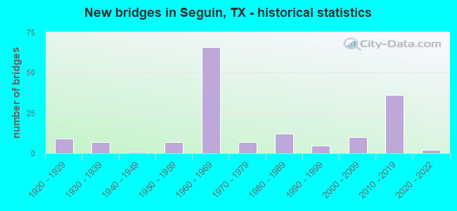
- New bridges - historical statistics
- 91920-1929
- 71930-1939
- 11940-1949
- 71950-1959
- 661960-1969
- 71970-1979
- 121980-1989
- 51990-1999
- 102000-2009
- 362010-2019
- 22020-2022

- Reconstructed bridges - Historical Statistics
- 61950-1959
- 71960-1969
- 21970-1979
- 51980-1989
- 21990-1999
- 62000-2009
- 32010-2019
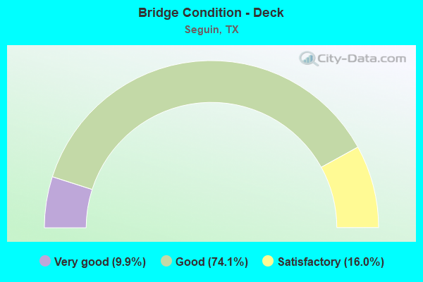
- Bridge Condition - Deck
- 9.9%Very good
- 74.1%Good
- 16.0%Satisfactory
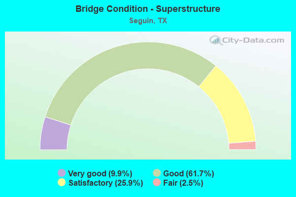
- Bridge Condition - Superstructure
- 9.9%Very good
- 61.7%Good
- 25.9%Satisfactory
- 2.5%Fair
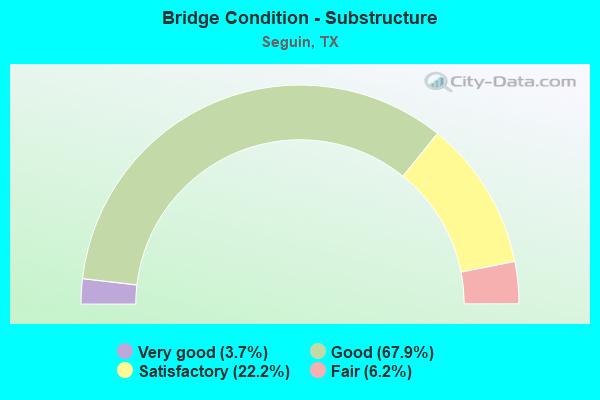
- Bridge Condition - Substructure
- 3.7%Very good
- 67.9%Good
- 22.2%Satisfactory
- 6.2%Fair
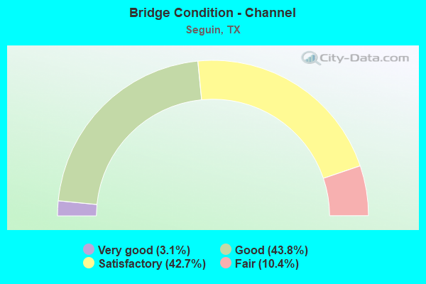
- Bridge Condition - Channel
- 3.1%Very good
- 43.8%Good
- 42.7%Satisfactory
- 10.4%Fair
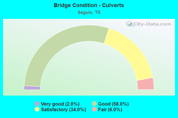
- Bridge Condition - Culverts
- 2.0%Very good
- 58.0%Good
- 34.0%Satisfactory
- 6.0%Fair
Find on map >> Show street view
Structure Number: 150950001606021, Location: 0.7 MI NORTH OF BEXAR C/L (Lat: 29.590575, Lng: -98.294886), Route carried "on" structure: Interstate 35, Year Built: 1934, Year Reconstructed: 1993, Status: Open, Structure Length: 2.83m (9.28ft), Average Daily Traffic: 94,227 (year 2020), Truck Traffic: 14%, Average Future Daily Traffic: 155,920 (year 2033), Features Intersected: DIETZ CREEK
Minimum Vertical Clearance: 30+ m (98+ ft), Kilometerpoint: 1.167, Lanes on structure: 13, Owner: State Highway Agency, Approaching Roadway Width: 56.7m (186.0ft), Skew: 30 degrees, Material/Design: Concrete, Design/Construction: Culvert, Number Of Spans In Main Unit: 14, Length of Maximum Span: 1.8m (5.9ft)
Condition: Channel: Satisfactory, Culverts: Satisfactory, Operating Rating: 32.7 metric tons, Method Used To Determine Operating Rating: Field evaluation and documented engineering judgment, Inventory Rating: 24.5 metric tons, Method Used To Determine Inventory Rating: Field evaluation and documented engineering judgment, Structural Evaluation: Equal to present minimum criteria, Waterway Adequacy: Equal to present minimum criteria, Approach Roadway Alignment: Equal to present desirable criteria, Length Of Structure Improvement: 2.83m (9.28ft), Designated Inspection Frequency: Every 24 months, Inspection Date: August 2020, Bridge Improvement Cost: $11,000, Roadway Improvement Cost: $3,000, Total Project Cost: $14,000
Find on map >> Show street view
Structure Number: 150950002503018, Location: 1.50 MI NE OF IH 10 (Lat: 29.558464, Lng: -98.018442), Route carried "on" structure: US 90, Year Built: 1932, Status: Open, Structure Length: 2.07m (6.79ft), Average Daily Traffic: 4,515 (year 2020), Truck Traffic: 11%, Average Future Daily Traffic: 6,350 (year 2033), Design Load: H 15, Features Intersected: DRAINAGE DITCH
Minimum Vertical Clearance: 30+ m (98+ ft), Kilometerpoint: 35.076, Lanes on structure: 2, Owner: State Highway Agency, Approaching Roadway Width: 12.2m (40.0ft), Material/Design: Concrete, Design/Construction: Culvert, Number Of Spans In Main Unit: 12, Length of Maximum Span: 1.5m (4.9ft), Curb-To-Curb Width: 12.2m (40.0ft), Out-to-Out Width: 13.1m (43.0ft)
Condition: Channel: Good, Culverts: Satisfactory, Operating Rating: 39.9 metric tons, Method Used To Determine Operating Rating: Load Factor (LF), Inventory Rating: 23.6 metric tons, Method Used To Determine Inventory Rating: Load Factor (LF), Structural Evaluation: Equal to present minimum criteria, Deck Geometry: Equal to present minimum criteria, Waterway Adequacy: Equal to present minimum criteria, Approach Roadway Alignment: Equal to present desirable criteria, Designated Inspection Frequency: Every 24 months, Inspection Date: August 2020, Deck Structure Type: Concrete Cast-file-Place, Wearing Surface/Protective System: Wearing Surface: Bituminous
Find on map >> Show street view
Structure Number: 150950002503019, Location: 2.00 MI E OF IH 10 (Lat: 29.562875, Lng: -98.010744), Route carried "on" structure: US 90, Year Built: 1932, Year Reconstructed: 1979, Status: Open, Structure Length: 28.35m (93.01ft), Average Daily Traffic: 5,622 (year 2020), Truck Traffic: 7%, Average Future Daily Traffic: 8,340 (year 2033), Design Load: H 15, Features Intersected: GUADALUPE RIVER
Minimum Vertical Clearance: 30+ m (98+ ft), Kilometerpoint: 35.748, Lanes on structure: 4, Owner: State Highway Agency, Approaching Roadway Width: 17.4m (57.1ft), Material/Design: Prestressed concrete, Design/Construction: Stringer/Multi-beam, Number Of Spans In Main Unit: 2, Number Of Approach Spans: 14, Length of Maximum Span: 30.8m (101.0ft), Curb or Sidewalk Widths: Left: 0.0m, Right: 1.5m (4.9ft), Curb-To-Curb Width: 15.9m (52.2ft), Out-to-Out Width: 18.0m (59.1ft)
Condition: Deck: Good, Superstructure: Satisfactory, Substructure: Good, Channel: Very good, Operating Rating: 45.4 metric tons, Method Used To Determine Operating Rating: Load Factor (LF), Inventory Rating: 27.2 metric tons, Method Used To Determine Inventory Rating: Load Factor (LF), Structural Evaluation: Equal to present minimum criteria, Deck Geometry: Meets minimum limits, Waterway Adequacy: Equal to present desirable criteria, Approach Roadway Alignment: Equal to present desirable criteria, Length Of Structure Improvement: 29.57m (97.01ft), Designated Inspection Frequency: Every 24 months, Underwater Inspection Frequency: Every 60 months, Inspection Date: August 2020, Underwater Inspection Date: May 2018, Bridge Improvement Cost: $1,494,000, Roadway Improvement Cost: $374,000, Total Project Cost: $1,868,000, Deck Structure Type: Concrete Cast-file-Place, Wearing Surface/Protective System: Wearing Surface: Bituminous
Find on map >> Show street view
Structure Number: 150950002503027, Location: 0.75 MI W OF SH 46 (Lat: 29.569344, Lng: -98.000114), Route carried "on" structure: US 90, Year Built: 1932, Year Reconstructed: 1967, Status: Open, Structure Length: 0.67m (2.20ft), Average Daily Traffic: 4,504 (year 2020), Truck Traffic: 7%, Average Future Daily Traffic: 8,340 (year 2033), Design Load: H 15, Features Intersected: DRAINAGE DITCH
Minimum Vertical Clearance: 30+ m (98+ ft), Kilometerpoint: 37.243, Lanes on structure: 5, Owner: State Highway Agency, Approaching Roadway Width: 15.9m (52.2ft), Skew: 1 degrees, Material/Design: Concrete, Design/Construction: Culvert, Number Of Spans In Main Unit: 3, Length of Maximum Span: 1.8m (5.9ft)
Condition: Channel: Good, Culverts: Satisfactory, Operating Rating: 32.7 metric tons, Method Used To Determine Operating Rating: Field evaluation and documented engineering judgment, Inventory Rating: 24.5 metric tons, Method Used To Determine Inventory Rating: Field evaluation and documented engineering judgment, Structural Evaluation: Equal to present minimum criteria, Waterway Adequacy: Equal to present minimum criteria, Approach Roadway Alignment: Equal to present desirable criteria, Designated Inspection Frequency: Every 24 months, Inspection Date: May 2020
Find on map >> Show street view
Structure Number: 150950002503092, Location: 0.30 MI W OF BUS 123 (Lat: 29.568878, Lng: -97.969133), Route carried "on" structure: Alternate US 90, Year Built: 1923, Year Reconstructed: 1967, Status: Open, Structure Length: 1.16m (3.81ft), Average Daily Traffic: 11,060 (year 2013), Truck Traffic: 5%, Average Future Daily Traffic: 15,480 (year 2033), Features Intersected: WALNUT BRANCH
Minimum Vertical Clearance: 30+ m (98+ ft), Kilometerpoint: 19.088, Lanes on structure: 5, Owner: State Highway Agency, Approaching Roadway Width: 19.5m (64.0ft), Skew: 3 degrees, Material/Design: Concrete, Design/Construction: Arch - Deck, Number Of Spans In Main Unit: 1, Length of Maximum Span: 10.7m (35.1ft), Curb or Sidewalk Widths: Left: 1.1m (3.6ft), Right: 0.0m, Curb-To-Curb Width: 19.5m (64.0ft), Out-to-Out Width: 21.4m (70.2ft)
Condition: Deck: Good, Superstructure: Good, Substructure: Good, Channel: Satisfactory, Operating Rating: 32.7 metric tons, Method Used To Determine Operating Rating: Field evaluation and documented engineering judgment, Inventory Rating: 24.5 metric tons, Method Used To Determine Inventory Rating: Field evaluation and documented engineering judgment, Structural Evaluation: Equal to present minimum criteria, Deck Geometry: Meets minimum limits, Waterway Adequacy: Equal to present minimum criteria, Approach Roadway Alignment: Equal to present desirable criteria, Designated Inspection Frequency: Every 24 months, Inspection Date: August 2020, Deck Structure Type: Concrete Cast-file-Place, Wearing Surface/Protective System: Wearing Surface: Bituminous
Find on map >> Show street view
Structure Number: 150950002503123, Location: IH 10 @ FM 775 (Lat: 29.540439, Lng: -98.072400), Route carried "on" structure: Interstate 10, Year Built: 1961, Status: Open, Structure Length: 3.66m (12.01ft), Average Daily Traffic: 23,205 (year 2019), Truck Traffic: 24%, Average Future Daily Traffic: 27,540 (year 2033), Design Load: HS 20, Features Intersected: FM 775
Minimum Vertical Clearance: 30+ m (98+ ft), Kilometerpoint: 11.856, Lanes on structure: 2, Lanes under structure: 2, Owner: State Highway Agency, Approaching Roadway Width: 11.6m (38.1ft), Material/Design: Concrete, Design/Construction: Stringer/Multi-beam, Number Of Spans In Main Unit: 3, Length of Maximum Span: 12.2m (40.0ft), Curb-To-Curb Width: 11.3m (37.1ft), Out-to-Out Width: 12.2m (40.0ft)
Condition: Deck: Satisfactory, Superstructure: Fair, Substructure: Satisfactory, Operating Rating: 58.0 metric tons, Method Used To Determine Operating Rating: Load Factor (LF), Inventory Rating: 34.5 metric tons, Method Used To Determine Inventory Rating: Load Factor (LF), Structural Evaluation: Somewhat better than minimum adequacy, Deck Geometry: Somewhat better than minimum adequacy, Underclear: Somewhat better than minimum adequacy, Approach Roadway Alignment: Equal to present desirable criteria, Designated Inspection Frequency: Every 24 months, Inspection Date: August 2020, Deck Structure Type: Concrete Cast-file-Place, Wearing Surface/Protective System: Wearing Surface: Bituminous
Find on map >> Show street view
Structure Number: 150950002503124, Location: IH 10 @ FM 775 (Lat: 29.540344, Lng: -98.072372), Route carried "on" structure: Interstate 10, Year Built: 1961, Status: Open, Structure Length: 3.66m (12.01ft), Average Daily Traffic: 22,983 (year 2019), Truck Traffic: 24%, Average Future Daily Traffic: 27,540 (year 2033), Design Load: HS 20, Features Intersected: FM 775
Minimum Vertical Clearance: 30+ m (98+ ft), Kilometerpoint: 11.856, Lanes on structure: 2, Lanes under structure: 2, Owner: State Highway Agency, Approaching Roadway Width: 11.6m (38.1ft), Material/Design: Concrete, Design/Construction: Stringer/Multi-beam, Number Of Spans In Main Unit: 3, Length of Maximum Span: 12.2m (40.0ft), Curb-To-Curb Width: 11.3m (37.1ft), Out-to-Out Width: 12.2m (40.0ft)
Condition: Deck: Satisfactory, Superstructure: Satisfactory, Substructure: Satisfactory, Operating Rating: 58.0 metric tons, Method Used To Determine Operating Rating: Load Factor (LF), Inventory Rating: 34.5 metric tons, Method Used To Determine Inventory Rating: Load Factor (LF), Structural Evaluation: Equal to present minimum criteria, Deck Geometry: Somewhat better than minimum adequacy, Underclear: Meets minimum limits, Approach Roadway Alignment: Equal to present desirable criteria, Designated Inspection Frequency: Every 24 months, Inspection Date: August 2020, Deck Structure Type: Concrete Cast-file-Place, Wearing Surface/Protective System: Wearing Surface: Bituminous
Find on map >> Show street view
Structure Number: 150950002504086, Location: 0.80 MI E OF SH 123 (Lat: 29.572869, Lng: -97.928250), Route carried "on" structure: Alternate US 90, Year Built: 1951, Year Reconstructed: 1967, Status: Open, Structure Length: 6.10m (20.01ft), Average Daily Traffic: 14,600 (year 2013), Truck Traffic: 3%, Average Future Daily Traffic: 20,440 (year 2033), Design Load: H 20, Features Intersected: GERONIMO CREEK
Minimum Vertical Clearance: 30+ m (98+ ft), Kilometerpoint: 26.641, Lanes on structure: 2, Owner: State Highway Agency, Approaching Roadway Width: 13.4m (44.0ft), Material/Design: Concrete continuous, Design/Construction: Slab, Number Of Spans In Main Unit: 8, Length of Maximum Span: 7.6m (24.9ft), Curb-To-Curb Width: 13.4m (44.0ft), Out-to-Out Width: 14.1m (46.3ft)
Condition: Deck: Satisfactory, Superstructure: Satisfactory, Substructure: Fair, Channel: Satisfactory, Operating Rating: 38.1 metric tons, Method Used To Determine Operating Rating: Load Factor (LF), Inventory Rating: 22.7 metric tons, Method Used To Determine Inventory Rating: Load Factor (LF), Structural Evaluation: Somewhat better than minimum adequacy, Deck Geometry: Equal to present minimum criteria, Waterway Adequacy: Equal to present minimum criteria, Approach Roadway Alignment: Equal to present desirable criteria, Designated Inspection Frequency: Every 24 months, Inspection Date: August 2020, Deck Structure Type: Concrete Cast-file-Place, Wearing Surface/Protective System: Wearing Surface: Bituminous
Find on map >> Show street view
Structure Number: 150950002504087, Location: 0.90 MI E OF SH 123 (Lat: 29.573244, Lng: -97.927222), Route carried "on" structure: Alternate US 90, Year Built: 1951, Year Reconstructed: 1967, Status: Open, Structure Length: 3.90m (12.80ft), Average Daily Traffic: 1,820 (year 2013), Truck Traffic: 2%, Average Future Daily Traffic: 2,550 (year 2033), Design Load: H 20, Features Intersected: BAER CREEK
Minimum Vertical Clearance: 30+ m (98+ ft), Kilometerpoint: 26.762, Lanes on structure: 2, Owner: State Highway Agency, Approaching Roadway Width: 13.4m (44.0ft), Skew: 3 degrees, Material/Design: Concrete, Design/Construction: Slab, Number Of Spans In Main Unit: 5, Length of Maximum Span: 7.6m (24.9ft), Curb-To-Curb Width: 13.4m (44.0ft), Out-to-Out Width: 14.1m (46.3ft)
Condition: Deck: Satisfactory, Superstructure: Satisfactory, Substructure: Satisfactory, Channel: Satisfactory, Operating Rating: 46.3 metric tons, Method Used To Determine Operating Rating: Load Factor (LF), Inventory Rating: 20.0 metric tons, Method Used To Determine Inventory Rating: Load Factor (LF), Structural Evaluation: Somewhat better than minimum adequacy, Deck Geometry: Equal to present desirable criteria, Waterway Adequacy: Equal to present minimum criteria, Approach Roadway Alignment: Equal to present desirable criteria, Designated Inspection Frequency: Every 24 months, Inspection Date: August 2020, Deck Structure Type: Concrete Cast-file-Place, Wearing Surface/Protective System: Wearing Surface: Bituminous
Find on map >> Show street view
Structure Number: 150950002504088, Location: 3.45 MI W OF FM 1150 (Lat: 29.567864, Lng: -97.829997), Route carried "on" structure: Alternate US 90, Year Built: 1951, Year Reconstructed: 1967, Status: Open, Structure Length: 6.71m (22.01ft), Average Daily Traffic: 3,810 (year 2013), Truck Traffic: 8%, Average Future Daily Traffic: 5,330 (year 2033), Design Load: H 20, Features Intersected: MILL CREEK
Minimum Vertical Clearance: 30+ m (98+ ft), Kilometerpoint: 36.601, Lanes on structure: 2, Owner: State Highway Agency, Approaching Roadway Width: 13.4m (44.0ft), Material/Design: Concrete continuous, Design/Construction: Slab, Number Of Spans In Main Unit: 8, Length of Maximum Span: 9.1m (29.9ft), Curb-To-Curb Width: 13.0m (42.7ft), Out-to-Out Width: 13.5m (44.3ft)
Condition: Deck: Good, Superstructure: Good, Substructure: Satisfactory, Channel: Satisfactory, Operating Rating: 43.5 metric tons, Method Used To Determine Operating Rating: Load Factor (LF), Inventory Rating: 26.3 metric tons, Method Used To Determine Inventory Rating: Load Factor (LF), Structural Evaluation: Equal to present minimum criteria, Deck Geometry: Equal to present minimum criteria, Waterway Adequacy: Equal to present minimum criteria, Approach Roadway Alignment: Equal to present desirable criteria, Designated Inspection Frequency: Every 24 months, Inspection Date: August 2020, Deck Structure Type: Concrete Cast-file-Place, Wearing Surface/Protective System: Wearing Surface: Bituminous
Find on map >> Show street view
Structure Number: 15095000250409, Location: 3.70 MI W OF FM 1150 (Lat: 29.567864, Lng: -97.834108), Route carried "on" structure: Alternate US 90, Year Built: 1952, Year Reconstructed: 1967, Status: Open, Structure Length: 0.67m (2.20ft), Average Daily Traffic: 3,810 (year 2013), Truck Traffic: 8%, Average Future Daily Traffic: 5,330 (year 2033), Design Load: HS 20, Features Intersected: DRAW
Minimum Vertical Clearance: 30+ m (98+ ft), Kilometerpoint: 36.188, Lanes on structure: 2, Owner: State Highway Agency, Approaching Roadway Width: 13.4m (44.0ft), Material/Design: Concrete, Design/Construction: Culvert, Number Of Spans In Main Unit: 2, Length of Maximum Span: 3.0m (9.8ft), Curb-To-Curb Width: 13.4m (44.0ft), Out-to-Out Width: 17.5m (57.4ft)
Condition: Channel: Satisfactory, Culverts: Fair, Operating Rating: 39.9 metric tons, Method Used To Determine Operating Rating: Load Factor (LF), Inventory Rating: 23.6 metric tons, Method Used To Determine Inventory Rating: Load Factor (LF), Structural Evaluation: Somewhat better than minimum adequacy, Deck Geometry: Better than present minimum criteria, Waterway Adequacy: Equal to present minimum criteria, Approach Roadway Alignment: Equal to present desirable criteria, Designated Inspection Frequency: Every 24 months, Inspection Date: August 2020, Deck Structure Type: Concrete Cast-file-Place, Wearing Surface/Protective System: Wearing Surface: Bituminous
Find on map >> Show street view
Structure Number: 150950002510208, Location: 0.7 MI WEST OF SH 46 (Lat: 29.590636, Lng: -98.005897), Route carried "on" structure: State highway 78, Year Built: 1987, Status: Open, Structure Length: 1.62m (5.31ft), Average Daily Traffic: 6,229 (year 2020), Truck Traffic: 5%, Average Future Daily Traffic: 7,240 (year 2033), Design Load: HS 20, Features Intersected: LITTLE MILL CREEK
Minimum Vertical Clearance: 30+ m (98+ ft), Kilometerpoint: 22.091, Lanes on structure: 4, Owner: State Highway Agency, Approaching Roadway Width: 23.2m (76.1ft), Skew: 20 degrees, Material/Design: Concrete, Design/Construction: Culvert, Number Of Spans In Main Unit: 5, Length of Maximum Span: 3.0m (9.8ft), Curb-To-Curb Width: 23.2m (76.1ft), Out-to-Out Width: 44.6m (146.3ft)
Condition: Channel: Satisfactory, Culverts: Good, Operating Rating: 39.9 metric tons, Method Used To Determine Operating Rating: Load Factor (LF), Inventory Rating: 23.6 metric tons, Method Used To Determine Inventory Rating: Load Factor (LF), Structural Evaluation: Somewhat better than minimum adequacy, Deck Geometry: Superior to present desirable criteria, Waterway Adequacy: Equal to present minimum criteria, Approach Roadway Alignment: Equal to present desirable criteria, Designated Inspection Frequency: Every 48 months, Inspection Date: September 2018, Deck Structure Type: Concrete Cast-file-Place, Wearing Surface/Protective System: Wearing Surface: Bituminous
Find on map >> Show street view
Structure Number: 150950002510313, Location: 0.5 MI SE OF IH 10 (Lat: 29.586153, Lng: -97.984894), Route carried "on" structure: State highway 78, Year Built: 2008, Status: Open, Structure Length: 2.44m (8.01ft), Average Daily Traffic: 5,408 (year 2020), Truck Traffic: 10%, Average Future Daily Traffic: 8,100 (year 2031), Design Load: HL 93, Features Intersected: WALNUT BRANCH
Minimum Vertical Clearance: 30+ m (98+ ft), Kilometerpoint: 28.986, Lanes on structure: 2, Owner: State Highway Agency, Approaching Roadway Width: 13.4m (44.0ft), Skew: 1 degrees, Material/Design: Prestressed concrete, Design/Construction: Box Beam or Girders - Multiple, Number Of Spans In Main Unit: 3, Length of Maximum Span: 9.1m (29.9ft), Curb-To-Curb Width: 13.4m (44.0ft), Out-to-Out Width: 14.0m (45.9ft)
Condition: Deck: Very good, Superstructure: Very good, Substructure: Very good, Channel: Good, Operating Rating: 54.4 metric tons, Method Used To Determine Operating Rating: Assigned ratings based on Load and Resistance Factor Design (LRFD) reported in metric tons, Inventory Rating: 32.7 metric tons, Method Used To Determine Inventory Rating: Assigned ratings based on Load and Resistance Factor Design (LRFD) reported in metric tons, Structural Evaluation: Equal to present desirable criteria, Deck Geometry: Equal to present minimum criteria, Waterway Adequacy: Equal to present minimum criteria, Approach Roadway Alignment: Equal to present desirable criteria, Designated Inspection Frequency: Every 24 months, Inspection Date: August 2020, Deck Structure Type: Concrete Cast-file-Place
Find on map >> Show street view
Structure Number: 150950002901002, Location: 0.65 MI E OF SH 46 (Lat: 29.579811, Lng: -97.980392), Route carried "on" structure: US 90, Year Built: 1932, Year Reconstructed: 1990, Status: Open, Structure Length: 1.89m (6.20ft), Average Daily Traffic: 8,132 (year 2020), Truck Traffic: 11%, Average Future Daily Traffic: 11,740 (year 2033), Design Load: H 15, Features Intersected: WALNUT BRANCH
Minimum Vertical Clearance: 30+ m (98+ ft), Kilometerpoint: 3.811, Lanes on structure: 4, Owner: State Highway Agency, Approaching Roadway Width: 15.9m (52.2ft), Material/Design: Concrete, Design/Construction: Culvert, Number Of Spans In Main Unit: 9, Length of Maximum Span: 3.4m (11.2ft), Curb or Sidewalk Widths: Left: 1.4m (4.6ft), Right: 1.4m (4.6ft), Curb-To-Curb Width: 15.6m (51.2ft), Out-to-Out Width: 19.6m (64.3ft)
Condition: Channel: Good, Culverts: Satisfactory, Operating Rating: 39.9 metric tons, Method Used To Determine Operating Rating: Load Factor (LF), Inventory Rating: 23.6 metric tons, Method Used To Determine Inventory Rating: Load Factor (LF), Structural Evaluation: Somewhat better than minimum adequacy, Deck Geometry: Meets minimum limits, Waterway Adequacy: Equal to present minimum criteria, Approach Roadway Alignment: Equal to present desirable criteria, Designated Inspection Frequency: Every 24 months, Inspection Date: August 2020, Deck Structure Type: Concrete Cast-file-Place, Wearing Surface/Protective System: Wearing Surface: Bituminous
Find on map >> Show street view
Structure Number: 150950002902003, Location: 0.55 MI NE OF SH 123 (Lat: 29.590408, Lng: -97.936064), Route carried "on" structure: US 90, Year Built: 1928, Year Reconstructed: 1950, Status: Open, Structure Length: 0.67m (2.20ft), Average Daily Traffic: 4,389 (year 2020), Truck Traffic: 7%, Average Future Daily Traffic: 4,870 (year 2033), Design Load: H 15, Features Intersected: GERONIMO CREEK RELIEF
Minimum Vertical Clearance: 30+ m (98+ ft), Kilometerpoint: 6.972, Lanes on structure: 2, Owner: State Highway Agency, Approaching Roadway Width: 13.1m (43.0ft), Material/Design: Concrete, Design/Construction: Culvert, Number Of Spans In Main Unit: 2, Length of Maximum Span: 3.0m (9.8ft), Curb-To-Curb Width: 13.1m (43.0ft), Out-to-Out Width: 15.9m (52.2ft)
Condition: Channel: Satisfactory, Culverts: Satisfactory, Operating Rating: 39.9 metric tons, Method Used To Determine Operating Rating: Load Factor (LF), Inventory Rating: 23.6 metric tons, Method Used To Determine Inventory Rating: Load Factor (LF), Structural Evaluation: Equal to present minimum criteria, Deck Geometry: Equal to present minimum criteria, Waterway Adequacy: Equal to present minimum criteria, Approach Roadway Alignment: Equal to present desirable criteria, Designated Inspection Frequency: Every 24 months, Inspection Date: September 2020, Deck Structure Type: Concrete Cast-file-Place, Wearing Surface/Protective System: Wearing Surface: Bituminous
Find on map >> Show street view
Structure Number: 150950002902004, Location: 0.65 MI NE OF SH 123 (Lat: 29.591081, Lng: -97.934856), Route carried "on" structure: US 90, Year Built: 1929, Year Reconstructed: 1950, Status: Open, Structure Length: 6.10m (20.01ft), Average Daily Traffic: 4,389 (year 2020), Truck Traffic: 7%, Average Future Daily Traffic: 4,870 (year 2033), Design Load: H 15, Features Intersected: GERONIMO CREEK
Minimum Vertical Clearance: 30+ m (98+ ft), Kilometerpoint: 7.118, Lanes on structure: 2, Owner: State Highway Agency, Approaching Roadway Width: 10.4m (34.1ft), Material/Design: Concrete, Design/Construction: Tee Beam, Number Of Spans In Main Unit: 7, Length of Maximum Span: 8.5m (27.9ft), Curb-To-Curb Width: 9.1m (29.9ft), Out-to-Out Width: 10.1m (33.1ft)
Condition: Deck: Satisfactory, Superstructure: Fair, Substructure: Fair, Channel: Satisfactory, Operating Rating: 44.4 metric tons, Method Used To Determine Operating Rating: Load Factor (LF), Inventory Rating: 26.3 metric tons, Method Used To Determine Inventory Rating: Load Factor (LF), Structural Evaluation: Somewhat better than minimum adequacy, Deck Geometry: Meets minimum limits, Waterway Adequacy: Equal to present minimum criteria, Approach Roadway Alignment: Equal to present desirable criteria, Designated Inspection Frequency: Every 24 months, Inspection Date: August 2020, Deck Structure Type: Concrete Cast-file-Place, Wearing Surface/Protective System: Wearing Surface: Bituminous
Find on map >> Show street view
Structure Number: 150950002902005, Location: 0.40 MI E OF IH 10 (Lat: 29.602936, Lng: -97.919817), Route carried "on" structure: US 90, Year Built: 1928, Year Reconstructed: 1950, Status: Open, Structure Length: 1.07m (3.51ft), Average Daily Traffic: 4,182 (year 2020), Truck Traffic: 6%, Average Future Daily Traffic: 5,830 (year 2033), Design Load: H 15, Features Intersected: BEAR CREEK
Minimum Vertical Clearance: 30+ m (98+ ft), Kilometerpoint: 9.080, Lanes on structure: 2, Owner: State Highway Agency, Approaching Roadway Width: 12.8m (42.0ft), Material/Design: Concrete, Design/Construction: Culvert, Number Of Spans In Main Unit: 4, Length of Maximum Span: 2.4m (7.9ft), Curb-To-Curb Width: 14.2m (46.6ft), Out-to-Out Width: 15.9m (52.2ft)
Condition: Channel: Satisfactory, Culverts: Fair, Operating Rating: 39.9 metric tons, Method Used To Determine Operating Rating: Load Factor (LF), Inventory Rating: 23.6 metric tons, Method Used To Determine Inventory Rating: Load Factor (LF), Structural Evaluation: Somewhat better than minimum adequacy, Deck Geometry: Superior to present desirable criteria, Waterway Adequacy: Equal to present minimum criteria, Approach Roadway Alignment: Equal to present desirable criteria, Designated Inspection Frequency: Every 24 months, Inspection Date: August 2020, Deck Structure Type: Concrete Cast-file-Place, Wearing Surface/Protective System: Wearing Surface: Bituminous
Find on map >> Show street view
Structure Number: 150950002902006, Location: 2.10 MI E OF IH 10 (Lat: 29.614047, Lng: -97.895667), Route carried "on" structure: US 90, Year Built: 1928, Year Reconstructed: 1950, Status: Open, Structure Length: 0.82m (2.69ft), Average Daily Traffic: 2,406 (year 2020), Truck Traffic: 7%, Average Future Daily Traffic: 3,310 (year 2033), Design Load: H 15, Features Intersected: W PRONG OF MILL CRK
Minimum Vertical Clearance: 30+ m (98+ ft), Kilometerpoint: 11.813, Lanes on structure: 2, Owner: State Highway Agency, Approaching Roadway Width: 12.2m (40.0ft), Material/Design: Concrete, Design/Construction: Culvert, Number Of Spans In Main Unit: 3, Length of Maximum Span: 2.4m (7.9ft), Curb-To-Curb Width: 13.4m (44.0ft), Out-to-Out Width: 14.0m (45.9ft)
Condition: Channel: Satisfactory, Culverts: Fair, Operating Rating: 39.9 metric tons, Method Used To Determine Operating Rating: Load Factor (LF), Inventory Rating: 23.6 metric tons, Method Used To Determine Inventory Rating: Load Factor (LF), Structural Evaluation: Somewhat better than minimum adequacy, Deck Geometry: Better than present minimum criteria, Waterway Adequacy: Equal to present minimum criteria, Approach Roadway Alignment: Equal to present desirable criteria, Designated Inspection Frequency: Every 24 months, Inspection Date: August 2020, Deck Structure Type: Concrete Cast-file-Place, Wearing Surface/Protective System: Wearing Surface: Bituminous
Find on map >> Show street view
Structure Number: 150950002902007, Location: 2.80 MI E OF IH 10 (Lat: 29.616022, Lng: -97.883839), Route carried "on" structure: US 90, Year Built: 1929, Year Reconstructed: 1950, Status: Open, Structure Length: 4.33m (14.21ft), Average Daily Traffic: 2,406 (year 2020), Truck Traffic: 7%, Average Future Daily Traffic: 3,310 (year 2033), Features Intersected: MILL CREEK
Minimum Vertical Clearance: 30+ m (98+ ft), Kilometerpoint: 12.955, Lanes on structure: 2, Owner: State Highway Agency, Approaching Roadway Width: 12.8m (42.0ft), Material/Design: Concrete, Design/Construction: Tee Beam, Number Of Spans In Main Unit: 5, Length of Maximum Span: 8.5m (27.9ft), Curb-To-Curb Width: 13.4m (44.0ft), Out-to-Out Width: 14.0m (45.9ft)
Condition: Deck: Good, Superstructure: Satisfactory, Substructure: Satisfactory, Channel: Satisfactory, Operating Rating: 48.1 metric tons, Method Used To Determine Operating Rating: Load Factor (LF), Inventory Rating: 28.1 metric tons, Method Used To Determine Inventory Rating: Load Factor (LF), Structural Evaluation: Equal to present minimum criteria, Deck Geometry: Better than present minimum criteria, Waterway Adequacy: Equal to present minimum criteria, Approach Roadway Alignment: Equal to present desirable criteria, Designated Inspection Frequency: Every 24 months, Inspection Date: September 2020, Deck Structure Type: Concrete Cast-file-Place, Wearing Surface/Protective System: Wearing Surface: Bituminous
Find on map >> Show street view
Structure Number: 150950002902182, Location: AT INTERSECTION US 90 (Lat: 29.619583, Lng: -97.877800), Route carried "on" structure: Other road 130, Year Built: 2012, Status: Open, Structure Length: 8.66m (28.41ft), Average Daily Traffic: 15,793 (year 2014), Truck Traffic: 15%, Average Future Daily Traffic: 40,695 (year 2034), Design Load: HL 93, Features Intersected: US 90
Minimum Vertical Clearance: 30+ m (98+ ft), Kilometerpoint: 150.261, Lanes on structure: 2, Lanes under structure: 3, Toll: On toll road, Owner: State Highway Agency, Maintenance Responsibility: State Toll Authority, Approaching Roadway Width: 12.2m (40.0ft), Skew: 9 degrees, Material/Design: Prestressed concrete, Design/Construction: Stringer/Multi-beam, Number Of Spans In Main Unit: 1, Number Of Approach Spans: 2, Length of Maximum Span: 43.9m (144.0ft), Curb-To-Curb Width: 13.9m (45.6ft), Out-to-Out Width: 14.6m (47.9ft)
Condition: Deck: Good, Superstructure: Good, Substructure: Satisfactory, Operating Rating: 54.4 metric tons, Method Used To Determine Operating Rating: Assigned ratings based on Load and Resistance Factor Design (LRFD) reported in metric tons, Inventory Rating: 32.7 metric tons, Method Used To Determine Inventory Rating: Assigned ratings based on Load and Resistance Factor Design (LRFD) reported in metric tons, Structural Evaluation: Equal to present minimum criteria, Deck Geometry: Superior to present desirable criteria, Underclear: Superior to present desirable criteria, Approach Roadway Alignment: Equal to present desirable criteria, Designated Inspection Frequency: Every 24 months, Inspection Date: September 2020, Deck Structure Type: Concrete Precast Panels
Find on map >> Show street view
Structure Number: 150950002902183, Location: AT INTERSECTION US 90 (Lat: 29.619083, Lng: -97.878517), Route carried "on" structure: Other road 130, Year Built: 2012, Status: Open, Structure Length: 9.08m (29.79ft), Average Daily Traffic: 15,793 (year 2014), Truck Traffic: 15%, Average Future Daily Traffic: 40,695 (year 2034), Design Load: HL 93, Features Intersected: US 90
Minimum Vertical Clearance: 30+ m (98+ ft), Kilometerpoint: 150.276, Lanes on structure: 2, Lanes under structure: 2, Toll: On toll road, Owner: State Highway Agency, Maintenance Responsibility: State Toll Authority, Approaching Roadway Width: 12.2m (40.0ft), Skew: 9 degrees, Material/Design: Prestressed concrete, Design/Construction: Stringer/Multi-beam, Number Of Spans In Main Unit: 1, Number Of Approach Spans: 2, Length of Maximum Span: 46.0m (150.9ft), Curb-To-Curb Width: 12.0m (39.4ft), Out-to-Out Width: 12.8m (42.0ft)
Condition: Deck: Good, Superstructure: Good, Substructure: Satisfactory, Operating Rating: 54.4 metric tons, Method Used To Determine Operating Rating: Assigned ratings based on Load and Resistance Factor Design (LRFD) reported in metric tons, Inventory Rating: 32.7 metric tons, Method Used To Determine Inventory Rating: Assigned ratings based on Load and Resistance Factor Design (LRFD) reported in metric tons, Structural Evaluation: Equal to present minimum criteria, Deck Geometry: Better than present minimum criteria, Underclear: Superior to present desirable criteria, Approach Roadway Alignment: Equal to present desirable criteria, Designated Inspection Frequency: Every 24 months, Inspection Date: September 2020, Deck Structure Type: Concrete Precast Panels
Find on map >> Show street view
Structure Number: 150950021602032, Location: 1.90 MI S OF IH 10 (Lat: 29.557619, Lng: -97.990328), Route carried "on" structure: State highway 46, Year Built: 1979, Status: Open, Structure Length: 0.94m (3.08ft), Average Daily Traffic: 8,005 (year 2020), Truck Traffic: 12%, Average Future Daily Traffic: 10,060 (year 2033), Design Load: HS 20, Features Intersected: CHAMBERS CREEK
Minimum Vertical Clearance: 30+ m (98+ ft), Kilometerpoint: 19.673, Lanes on structure: 2, Owner: State Highway Agency, Approaching Roadway Width: 13.4m (44.0ft), Skew: 4 degrees, Material/Design: Concrete, Design/Construction: Culvert, Number Of Spans In Main Unit: 2, Length of Maximum Span: 3.0m (9.8ft)
Condition: Channel: Very good, Culverts: Good, Operating Rating: 39.9 metric tons, Method Used To Determine Operating Rating: Load Factor (LF), Inventory Rating: 23.6 metric tons, Method Used To Determine Inventory Rating: Load Factor (LF), Structural Evaluation: Somewhat better than minimum adequacy, Waterway Adequacy: Equal to present minimum criteria, Approach Roadway Alignment: Equal to present desirable criteria, Designated Inspection Frequency: Every 48 months, Inspection Date: September 2018
Find on map >> Show street view
Structure Number: 150950021602033, Location: 2.35 MI S OF IH 10 (Lat: 29.550769, Lng: -97.990397), Route carried "on" structure: State highway 46, Year Built: 1979, Status: Open, Structure Length: 11.28m (37.01ft), Average Daily Traffic: 8,005 (year 2020), Truck Traffic: 12%, Average Future Daily Traffic: 10,060 (year 2033), Design Load: HS 20, Features Intersected: GUADALUPE RIVER
Minimum Vertical Clearance: 30+ m (98+ ft), Kilometerpoint: 20.426, Lanes on structure: 2, Owner: State Highway Agency, Approaching Roadway Width: 13.4m (44.0ft), Material/Design: Prestressed concrete, Design/Construction: Stringer/Multi-beam, Number Of Spans In Main Unit: 4, Number Of Approach Spans: 1, Length of Maximum Span: 24.4m (80.1ft), Curb-To-Curb Width: 13.4m (44.0ft), Out-to-Out Width: 14.0m (45.9ft)
Condition: Deck: Good, Superstructure: Good, Substructure: Good, Channel: Fair, Operating Rating: 54.4 metric tons, Method Used To Determine Operating Rating: Assigned rating based on Load Factor Design (LFD) reported in metric tons, Inventory Rating: 32.7 metric tons, Method Used To Determine Inventory Rating: Assigned rating based on Load Factor Design (LFD) reported in metric tons, Structural Evaluation: Better than present minimum criteria, Deck Geometry: Equal to present minimum criteria, Waterway Adequacy: Equal to present minimum criteria, Approach Roadway Alignment: Equal to present desirable criteria, Designated Inspection Frequency: Every 24 months, Underwater Inspection Frequency: Every 60 months, Inspection Date: September 2020, Underwater Inspection Date: November 2019, Deck Structure Type: Concrete Cast-file-Place, Wearing Surface/Protective System: Wearing Surface: Bituminous
Find on map >> Show street view
Structure Number: 150950021602037, Location: 0.10 MI SE OF FM 725 (Lat: 29.534997, Lng: -97.985578), Route carried "on" structure: State highway 46, Year Built: 1987, Status: Open, Structure Length: 0.94m (3.08ft), Average Daily Traffic: 8,005 (year 2020), Truck Traffic: 12%, Average Future Daily Traffic: 9,090 (year 2033), Design Load: HS 20, Features Intersected: MAYS CREEK
Minimum Vertical Clearance: 30+ m (98+ ft), Kilometerpoint: 22.267, Lanes on structure: 2, Owner: State Highway Agency, Approaching Roadway Width: 13.4m (44.0ft), Material/Design: Concrete, Design/Construction: Culvert, Number Of Spans In Main Unit: 3, Length of Maximum Span: 3.0m (9.8ft), Curb-To-Curb Width: 13.4m (44.0ft), Out-to-Out Width: 17.7m (58.1ft)
Condition: Channel: Satisfactory, Culverts: Good, Operating Rating: 39.9 metric tons, Method Used To Determine Operating Rating: Load Factor (LF), Inventory Rating: 23.6 metric tons, Method Used To Determine Inventory Rating: Load Factor (LF), Structural Evaluation: Somewhat better than minimum adequacy, Deck Geometry: Equal to present minimum criteria, Waterway Adequacy: Equal to present minimum criteria, Approach Roadway Alignment: Equal to present desirable criteria, Designated Inspection Frequency: Every 48 months, Inspection Date: September 2018, Deck Structure Type: Concrete Cast-file-Place, Wearing Surface/Protective System: Wearing Surface: Bituminous
Find on map >> Show street view
Structure Number: 150950021602038, Location: 1.15 MI SE OF FM 725 (Lat: 29.527469, Lng: -97.970653), Route carried "on" structure: State highway 46, Year Built: 1987, Status: Open, Structure Length: 1.10m (3.61ft), Average Daily Traffic: 7,040 (year 2020), Truck Traffic: 12%, Average Future Daily Traffic: 7,560 (year 2033), Design Load: HS 20, Features Intersected: DRAW
Minimum Vertical Clearance: 30+ m (98+ ft), Kilometerpoint: 23.989, Lanes on structure: 2, Owner: State Highway Agency, Approaching Roadway Width: 13.4m (44.0ft), Skew: 4 degrees, Material/Design: Concrete, Design/Construction: Culvert, Number Of Spans In Main Unit: 3, Length of Maximum Span: 2.4m (7.9ft), Curb-To-Curb Width: 13.4m (44.0ft), Out-to-Out Width: 17.7m (58.1ft)
Condition: Channel: Good, Culverts: Good, Operating Rating: 39.9 metric tons, Method Used To Determine Operating Rating: Load Factor (LF), Inventory Rating: 23.6 metric tons, Method Used To Determine Inventory Rating: Load Factor (LF), Structural Evaluation: Somewhat better than minimum adequacy, Deck Geometry: Equal to present minimum criteria, Waterway Adequacy: Equal to present minimum criteria, Approach Roadway Alignment: Equal to present desirable criteria, Designated Inspection Frequency: Every 48 months, Inspection Date: September 2018, Deck Structure Type: Concrete Cast-file-Place, Wearing Surface/Protective System: Wearing Surface: Bituminous
Find on map >> Show street view
Structure Number: 150950021602043, Location: 1.2 MI N OF IH 10 (Lat: 29.598908, Lng: -98.004800), Route carried "on" structure: State highway 46, Year Built: 2000, Status: Open, Structure Length: 5.18m (16.99ft), Average Daily Traffic: 19,908 (year 2020), Truck Traffic: 8%, Average Future Daily Traffic: 29,540 (year 2033), Design Load: HS 20, Features Intersected: LITTLE MILL CREEK
Minimum Vertical Clearance: 30+ m (98+ ft), Kilometerpoint: 12.751, Lanes on structure: 5, Owner: State Highway Agency, Approaching Roadway Width: 25.0m (82.0ft), Skew: 3 degrees, Material/Design: Concrete, Design/Construction: Culvert, Number Of Spans In Main Unit: 15, Length of Maximum Span: 2.4m (7.9ft), Curb-To-Curb Width: 25.0m (82.0ft), Out-to-Out Width: 25.6m (84.0ft)
Condition: Channel: Satisfactory, Culverts: Good, Operating Rating: 44.4 metric tons, Method Used To Determine Operating Rating: Assigned rating based on Load Factor Design (LFD) reported in metric tons, Inventory Rating: 32.7 metric tons, Method Used To Determine Inventory Rating: Assigned rating based on Load Factor Design (LFD) reported in metric tons, Structural Evaluation: Better than present minimum criteria, Deck Geometry: Superior to present desirable criteria, Waterway Adequacy: Equal to present minimum criteria, Approach Roadway Alignment: Equal to present desirable criteria, Designated Inspection Frequency: Every 48 months, Inspection Date: September 2018, Deck Structure Type: Concrete Cast-file-Place, Wearing Surface/Protective System: Wearing Surface: Bituminous
Find on map >> Show street view
Structure Number: 150950021602203, Location: 0.3 MI N OF IH 10 (Lat: 29.588181, Lng: -97.994556), Route carried "on" structure: State highway 46, Year Built: 1966, Year Reconstructed: 1997, Status: Open, Structure Length: 11.58m (37.99ft), Average Daily Traffic: 19,908 (year 2020), Truck Traffic: 7%, Average Future Daily Traffic: 37,980 (year 2033), Design Load: H 20, Features Intersected: UPRR & FM 78
Minimum Vertical Clearance: 30+ m (98+ ft), Kilometerpoint: 1.609, Lanes on structure: 5, Lanes under structure: 3, Owner: State Highway Agency, Approaching Roadway Width: 26.5m (86.9ft), Skew: 4 degrees, Material/Design: Steel continuous, Design/Construction: Stringer/Multi-beam, Number Of Spans In Main Unit: 5, Number Of Approach Spans: 1, Length of Maximum Span: 24.4m (80.1ft), Curb-To-Curb Width: 26.5m (86.9ft), Out-to-Out Width: 27.4m (89.9ft)
Condition: Deck: Good, Superstructure: Satisfactory, Substructure: Satisfactory, Operating Rating: 41.7 metric tons, Method Used To Determine Operating Rating: Load Factor (LF), Inventory Rating: 24.5 metric tons, Method Used To Determine Inventory Rating: Load Factor (LF), Structural Evaluation: Equal to present minimum criteria, Deck Geometry: Superior to present desirable criteria, Underclear: Meets minimum limits, Approach Roadway Alignment: Equal to present desirable criteria, Designated Inspection Frequency: Every 24 months, Inspection Date: August 2020, Deck Structure Type: Concrete Cast-file-Place, Wearing Surface/Protective System: Wearing Surface: Bituminous
Find on map >> Show street view
Structure Number: 150950021603013, Location: 2.85 MI S OF US 90A (Lat: 29.540100, Lng: -97.928667), Route carried "on" structure: State highway 466, Year Built: 1964, Status: Open, Structure Length: 18.96m (62.20ft), Average Daily Traffic: 4,888 (year 2020), Truck Traffic: 6%, Average Future Daily Traffic: 6,150 (year 2033), Design Load: HS 20, Features Intersected: GUADALUPE RIVER
Minimum Vertical Clearance: 30+ m (98+ ft), Kilometerpoint: 12.571, Lanes on structure: 2, Owner: State Highway Agency, Approaching Roadway Width: 7.3m (24.0ft), Material/Design: Steel continuous, Design/Construction: Stringer/Multi-beam, Number Of Spans In Main Unit: 4, Number Of Approach Spans: 6, Length of Maximum Span: 27.4m (89.9ft), Curb-To-Curb Width: 8.5m (27.9ft), Out-to-Out Width: 9.5m (31.2ft)
Condition: Deck: Good, Superstructure: Satisfactory, Substructure: Good, Channel: Satisfactory, Operating Rating: 45.4 metric tons, Method Used To Determine Operating Rating: Load Factor (LF), Inventory Rating: 27.2 metric tons, Method Used To Determine Inventory Rating: Load Factor (LF), Structural Evaluation: Equal to present minimum criteria, Deck Geometry: Meets minimum limits, Waterway Adequacy: Equal to present minimum criteria, Approach Roadway Alignment: Equal to present desirable criteria, Designated Inspection Frequency: Every 24 months, Inspection Date: August 2020, Deck Structure Type: Concrete Cast-file-Place, Wearing Surface/Protective System: Wearing Surface: Bituminous
Find on map >> Show street view
Structure Number: 15095002160304, Location: 1.50 MI W OF FM 1117 (Lat: 29.526392, Lng: -97.901411), Route carried "on" structure: State highway 466, Year Built: 1991, Status: Open, Structure Length: 2.74m (8.99ft), Average Daily Traffic: 4,017 (year 2020), Truck Traffic: 3%, Average Future Daily Traffic: 5,290 (year 2033), Design Load: HS 20, Features Intersected: CANTAU CREEK
Minimum Vertical Clearance: 30+ m (98+ ft), Kilometerpoint: 16.370, Lanes on structure: 2, Owner: State Highway Agency, Approaching Roadway Width: 8.5m (27.9ft), Skew: 4 degrees, Material/Design: Concrete, Design/Construction: Culvert, Number Of Spans In Main Unit: 6, Length of Maximum Span: 3.0m (9.8ft), Curb-To-Curb Width: 13.4m (44.0ft), Out-to-Out Width: 14.0m (45.9ft)
Condition: Channel: Fair, Culverts: Satisfactory, Operating Rating: 39.9 metric tons, Method Used To Determine Operating Rating: Load Factor (LF), Inventory Rating: 23.6 metric tons, Method Used To Determine Inventory Rating: Load Factor (LF), Structural Evaluation: Equal to present minimum criteria, Deck Geometry: Better than present minimum criteria, Waterway Adequacy: Equal to present minimum criteria, Approach Roadway Alignment: Equal to present desirable criteria, Designated Inspection Frequency: Every 24 months, Inspection Date: September 2020, Deck Structure Type: Concrete Cast-file-Place, Wearing Surface/Protective System: Wearing Surface: Bituminous
Find on map >> Show street view
Structure Number: 150950021603041, Location: 1.70 MI W OF FM 1117 (Lat: 29.527456, Lng: -97.904867), Route carried "on" structure: State highway 466, Year Built: 1991, Status: Open, Structure Length: 1.59m (5.22ft), Average Daily Traffic: 4,017 (year 2020), Truck Traffic: 3%, Average Future Daily Traffic: 5,290 (year 2033), Design Load: HS 20, Features Intersected: DRAW
Minimum Vertical Clearance: 30+ m (98+ ft), Kilometerpoint: 16.129, Lanes on structure: 2, Owner: State Highway Agency, Approaching Roadway Width: 8.5m (27.9ft), Material/Design: Concrete, Design/Construction: Culvert, Number Of Spans In Main Unit: 7, Length of Maximum Span: 2.1m (6.9ft), Curb-To-Curb Width: 13.2m (43.3ft), Out-to-Out Width: 14.0m (45.9ft)
Condition: Channel: Good, Culverts: Good, Operating Rating: 39.9 metric tons, Method Used To Determine Operating Rating: Load Factor (LF), Inventory Rating: 23.6 metric tons, Method Used To Determine Inventory Rating: Load Factor (LF), Structural Evaluation: Equal to present minimum criteria, Deck Geometry: Equal to present minimum criteria, Waterway Adequacy: Equal to present minimum criteria, Approach Roadway Alignment: Equal to present desirable criteria, Designated Inspection Frequency: Every 48 months, Inspection Date: September 2018, Deck Structure Type: Concrete Cast-file-Place, Wearing Surface/Protective System: Wearing Surface: Bituminous
Find on map >> Show street view
Structure Number: 150950021605034, Location: 2.15 MI S OF US 90A (Lat: 29.536650, Lng: -97.880533), Route carried "on" structure: State highway 1117, Year Built: 1984, Status: Open, Structure Length: 7.32m (24.02ft), Average Daily Traffic: 1,426 (year 2020), Truck Traffic: 3%, Average Future Daily Traffic: 1,930 (year 2033), Design Load: HS 20, Features Intersected: GUADALUPE RIVER
Minimum Vertical Clearance: 30+ m (98+ ft), Kilometerpoint: 14.325, Lanes on structure: 2, Owner: State Highway Agency, Approaching Roadway Width: 10.4m (34.1ft), Skew: 3 degrees, Material/Design: Concrete, Design/Construction: Slab, Number Of Spans In Main Unit: 8, Length of Maximum Span: 9.1m (29.9ft), Curb-To-Curb Width: 10.9m (35.8ft), Out-to-Out Width: 11.6m (38.1ft)
Condition: Deck: Good, Superstructure: Good, Substructure: Fair, Channel: Fair, Operating Rating: 54.4 metric tons, Method Used To Determine Operating Rating: Assigned rating based on Load Factor Design (LFD) reported in metric tons, Inventory Rating: 32.7 metric tons, Method Used To Determine Inventory Rating: Assigned rating based on Load Factor Design (LFD) reported in metric tons, Structural Evaluation: Somewhat better than minimum adequacy, Deck Geometry: Equal to present minimum criteria, Waterway Adequacy: Equal to present minimum criteria, Approach Roadway Alignment: Equal to present desirable criteria, Designated Inspection Frequency: Every 24 months, Underwater Inspection Frequency: Every 60 months, Inspection Date: August 2020, Underwater Inspection Date: August 2017, Deck Structure Type: Concrete Cast-file-Place, Wearing Surface/Protective System: Wearing Surface: Bituminous
Find on map >> Show street view
Structure Number: 150950021605035, Location: 2.45 MI S OF US 90A (Lat: 29.532064, Lng: -97.879094), Route carried "on" structure: State highway 1117, Year Built: 1984, Status: Open, Structure Length: 0.67m (2.20ft), Average Daily Traffic: 1,426 (year 2020), Truck Traffic: 3%, Average Future Daily Traffic: 1,930 (year 2033), Design Load: HS 20, Features Intersected: DRAW
Minimum Vertical Clearance: 30+ m (98+ ft), Kilometerpoint: 14.816, Lanes on structure: 2, Owner: State Highway Agency, Approaching Roadway Width: 11.0m (36.1ft), Material/Design: Concrete, Design/Construction: Culvert, Number Of Spans In Main Unit: 3, Length of Maximum Span: 2.1m (6.9ft), Curb-To-Curb Width: 11.0m (36.1ft), Out-to-Out Width: 17.5m (57.4ft)
Condition: Channel: Satisfactory, Culverts: Good, Operating Rating: 39.9 metric tons, Method Used To Determine Operating Rating: Load Factor (LF), Inventory Rating: 23.6 metric tons, Method Used To Determine Inventory Rating: Load Factor (LF), Structural Evaluation: Equal to present minimum criteria, Deck Geometry: Equal to present minimum criteria, Waterway Adequacy: Equal to present minimum criteria, Approach Roadway Alignment: Equal to present desirable criteria, Designated Inspection Frequency: Every 48 months, Inspection Date: September 2018, Deck Structure Type: Concrete Cast-file-Place, Wearing Surface/Protective System: Wearing Surface: Bituminous
Find on map >> Show street view
Structure Number: 150950021605036, Location: 0.55 MI S OF US 90A (Lat: 29.559436, Lng: -97.882131), Route carried "on" structure: State highway 1117, Year Built: 1984, Status: Open, Structure Length: 1.34m (4.40ft), Average Daily Traffic: 1,426 (year 2020), Truck Traffic: 3%, Average Future Daily Traffic: 1,930 (year 2033), Design Load: HS 20, Features Intersected: DRAW
Minimum Vertical Clearance: 30+ m (98+ ft), Kilometerpoint: 11.697, Lanes on structure: 2, Owner: State Highway Agency, Approaching Roadway Width: 11.0m (36.1ft), Skew: 4 degrees, Material/Design: Concrete, Design/Construction: Culvert, Number Of Spans In Main Unit: 3, Length of Maximum Span: 3.0m (9.8ft)
Condition: Channel: Good, Culverts: Good, Operating Rating: 39.9 metric tons, Method Used To Determine Operating Rating: Load Factor (LF), Inventory Rating: 23.6 metric tons, Method Used To Determine Inventory Rating: Load Factor (LF), Structural Evaluation: Equal to present minimum criteria, Waterway Adequacy: Equal to present minimum criteria, Approach Roadway Alignment: Equal to present desirable criteria, Designated Inspection Frequency: Every 48 months, Inspection Date: September 2018
Find on map >> Show street view
Structure Number: 150950021605039, Location: 0.10 MI S OF US 90A (Lat: 29.565833, Lng: -97.882222), Route carried "on" structure: State highway 1117, Year Built: 1984, Status: Open, Structure Length: 0.70m (2.30ft), Average Daily Traffic: 1,426 (year 2020), Truck Traffic: 3%, Average Future Daily Traffic: 1,930 (year 2033), Design Load: HS 20, Features Intersected: DRAW
Minimum Vertical Clearance: 30+ m (98+ ft), Kilometerpoint: 11.014, Lanes on structure: 2, Owner: State Highway Agency, Approaching Roadway Width: 11.0m (36.1ft), Skew: 4 degrees, Material/Design: Concrete, Design/Construction: Culvert, Number Of Spans In Main Unit: 2, Length of Maximum Span: 2.4m (7.9ft)
Condition: Channel: Good, Culverts: Good, Operating Rating: 39.9 metric tons, Method Used To Determine Operating Rating: Load Factor (LF), Inventory Rating: 23.6 metric tons, Method Used To Determine Inventory Rating: Load Factor (LF), Structural Evaluation: Equal to present minimum criteria, Waterway Adequacy: Equal to present minimum criteria, Approach Roadway Alignment: Equal to present desirable criteria, Designated Inspection Frequency: Every 48 months, Inspection Date: September 2018
Find on map >> Show street view
Structure Number: 150950036602005, Location: 0.3 MI N OF US 90A (Lat: 29.572297, Lng: -97.940164), Route carried "on" structure: State highway 123, Year Built: 2007, Status: Open, Structure Length: 0.67m (2.20ft), Average Daily Traffic: 18,128 (year 2020), Truck Traffic: 12%, Average Future Daily Traffic: 29,810 (year 2033), Design Load: HS 20, Features Intersected: DRAINAGE DITCH
Minimum Vertical Clearance: 30+ m (98+ ft), Kilometerpoint: 38.203, Lanes on structure: 4, Owner: State Highway Agency, Approaching Roadway Width: 17.1m (56.1ft), Skew: 9 degrees, Material/Design: Concrete, Design/Construction: Culvert, Number Of Spans In Main Unit: 3, Length of Maximum Span: 2.1m (6.9ft)
Condition: Channel: Good, Culverts: Good, Operating Rating: 54.4 metric tons, Method Used To Determine Operating Rating: Assigned rating based on Load Factor Design (LFD) reported in metric tons, Inventory Rating: 32.7 metric tons, Method Used To Determine Inventory Rating: Assigned rating based on Load Factor Design (LFD) reported in metric tons, Structural Evaluation: Better than present minimum criteria, Waterway Adequacy: Equal to present minimum criteria, Approach Roadway Alignment: Equal to present desirable criteria, Designated Inspection Frequency: Every 24 months, Inspection Date: September 2020
Find on map >> Show street view
Structure Number: 150950036602009, Location: 4.3 MI S OF JCT FM 758 (Lat: 29.641433, Lng: -97.967133), Route carried "on" structure: State highway 123, Year Built: 1928, Year Reconstructed: 1980, Status: Open, Structure Length: 0.82m (2.69ft), Average Daily Traffic: 10,965 (year 2020), Truck Traffic: 12%, Average Future Daily Traffic: 14,630 (year 2033), Design Load: H 15, Features Intersected: DRY BRANCH
Minimum Vertical Clearance: 30+ m (98+ ft), Kilometerpoint: 18.536, Lanes on structure: 4, Owner: State Highway Agency, Approaching Roadway Width: 16.5m (54.1ft), Material/Design: Concrete, Design/Construction: Culvert, Number Of Spans In Main Unit: 4, Length of Maximum Span: 1.8m (5.9ft), Curb-To-Curb Width: 15.9m (52.2ft), Out-to-Out Width: 23.9m (78.4ft)
Condition: Channel: Fair, Culverts: Satisfactory, Operating Rating: 39.9 metric tons, Method Used To Determine Operating Rating: Load Factor (LF), Inventory Rating: 23.6 metric tons, Method Used To Determine Inventory Rating: Load Factor (LF), Structural Evaluation: Somewhat better than minimum adequacy, Deck Geometry: Meets minimum limits, Waterway Adequacy: Equal to present minimum criteria, Approach Roadway Alignment: Equal to present desirable criteria, Designated Inspection Frequency: Every 24 months, Inspection Date: August 2020, Deck Structure Type: Concrete Cast-file-Place, Wearing Surface/Protective System: Wearing Surface: Bituminous
Find on map >> Show street view
Structure Number: 15095003660201, Location: 5.2 MI S OF JCT FM 758 (Lat: 29.629378, Lng: -97.967214), Route carried "on" structure: State highway 123, Year Built: 1928, Year Reconstructed: 1980, Status: Open, Structure Length: 0.82m (2.69ft), Average Daily Traffic: 10,965 (year 2020), Truck Traffic: 12%, Average Future Daily Traffic: 14,630 (year 2033), Design Load: H 15, Features Intersected: DRAW
Minimum Vertical Clearance: 30+ m (98+ ft), Kilometerpoint: 19.998, Lanes on structure: 3, Owner: State Highway Agency, Approaching Roadway Width: 15.2m (49.9ft), Material/Design: Concrete, Design/Construction: Culvert, Number Of Spans In Main Unit: 4, Length of Maximum Span: 1.8m (5.9ft), Curb-To-Curb Width: 15.2m (49.9ft), Out-to-Out Width: 25.1m (82.3ft)
Condition: Channel: Satisfactory, Culverts: Good, Operating Rating: 39.9 metric tons, Method Used To Determine Operating Rating: Load Factor (LF), Inventory Rating: 23.6 metric tons, Method Used To Determine Inventory Rating: Load Factor (LF), Structural Evaluation: Somewhat better than minimum adequacy, Deck Geometry: Equal to present minimum criteria, Waterway Adequacy: Equal to present minimum criteria, Approach Roadway Alignment: Equal to present desirable criteria, Designated Inspection Frequency: Every 24 months, Inspection Date: August 2020, Deck Structure Type: Concrete Cast-file-Place, Wearing Surface/Protective System: Wearing Surface: Bituminous
Find on map >> Show street view
Structure Number: 150950036602015, Location: 0.6 MI S OF IH 10 (Lat: 29.590956, Lng: -97.946169), Route carried "on" structure: State highway 123, Year Built: 2007, Status: Open, Structure Length: 6.40m (21.00ft), Average Daily Traffic: 8,362 (year 2020), Truck Traffic: 12%, Average Future Daily Traffic: 11,780 (year 2033), Design Load: HS 20, Features Intersected: UPRR
Minimum Vertical Clearance: 30+ m (98+ ft), Kilometerpoint: 35.983, Lanes on structure: 3, Owner: State Highway Agency, Approaching Roadway Width: 15.2m (49.9ft), Material/Design: Prestressed concrete, Design/Construction: Stringer/Multi-beam, Number Of Spans In Main Unit: 2, Length of Maximum Span: 35.1m (115.2ft), Curb-To-Curb Width: 15.2m (49.9ft), Out-to-Out Width: 15.9m (52.2ft)
Condition: Deck: Good, Superstructure: Very good, Substructure: Good, Operating Rating: 54.4 metric tons, Method Used To Determine Operating Rating: Assigned rating based on Load Factor Design (LFD) reported in metric tons, Inventory Rating: 32.7 metric tons, Method Used To Determine Inventory Rating: Assigned rating based on Load Factor Design (LFD) reported in metric tons, Structural Evaluation: Better than present minimum criteria, Deck Geometry: Equal to present minimum criteria, Underclear: Superior to present desirable criteria, Approach Roadway Alignment: Equal to present desirable criteria, Designated Inspection Frequency: Every 24 months, Inspection Date: August 2020, Deck Structure Type: Concrete Precast Panels
Find on map >> Show street view
Structure Number: 150950036602057, Location: 0.50 MI N OF IH 10 (Lat: 29.605192, Lng: -97.956072), Route carried "on" structure: State highway 123, Year Built: 1968, Status: Open, Structure Length: 1.10m (3.61ft), Average Daily Traffic: 9,143 (year 2020), Truck Traffic: 12%, Average Future Daily Traffic: 12,640 (year 2033), Design Load: HS 20, Features Intersected: DRAW
Minimum Vertical Clearance: 30+ m (98+ ft), Kilometerpoint: 34.182, Lanes on structure: 2, Owner: State Highway Agency, Approaching Roadway Width: 12.2m (40.0ft), Skew: 1 degrees, Material/Design: Concrete, Design/Construction: Culvert, Number Of Spans In Main Unit: 4, Length of Maximum Span: 2.4m (7.9ft)
Condition: Channel: Good, Culverts: Good, Operating Rating: 39.9 metric tons, Method Used To Determine Operating Rating: Load Factor (LF), Inventory Rating: 23.6 metric tons, Method Used To Determine Inventory Rating: Load Factor (LF), Structural Evaluation: Somewhat better than minimum adequacy, Waterway Adequacy: Equal to present minimum criteria, Approach Roadway Alignment: Equal to present desirable criteria, Designated Inspection Frequency: Every 24 months, Inspection Date: September 2020
Find on map >> Show street view
Structure Number: 150950036602058, Location: 0.60 MI S OF IH 10 (Lat: 29.591308, Lng: -97.946864), Route carried "on" structure: State highway 123, Year Built: 1968, Status: Open, Structure Length: 5.79m (19.00ft), Average Daily Traffic: 8,358 (year 2020), Truck Traffic: 12%, Average Future Daily Traffic: 11,780 (year 2033), Design Load: HS 20, Features Intersected: UPRR
Minimum Vertical Clearance: 30+ m (98+ ft), Kilometerpoint: 35.978, Lanes on structure: 2, Owner: State Highway Agency, Approaching Roadway Width: 12.2m (40.0ft), Material/Design: Prestressed concrete, Design/Construction: Stringer/Multi-beam, Number Of Spans In Main Unit: 4, Length of Maximum Span: 16.8m (55.1ft), Curb-To-Curb Width: 12.2m (40.0ft), Out-to-Out Width: 12.9m (42.3ft)
Condition: Deck: Very good, Superstructure: Good, Substructure: Good, Operating Rating: 68.0 metric tons, Method Used To Determine Operating Rating: Load Factor (LF), Inventory Rating: 34.5 metric tons, Method Used To Determine Inventory Rating: Load Factor (LF), Structural Evaluation: Better than present minimum criteria, Deck Geometry: Better than present minimum criteria, Underclear: Superior to present desirable criteria, Approach Roadway Alignment: Equal to present desirable criteria, Designated Inspection Frequency: Every 24 months, Inspection Date: August 2020, Deck Structure Type: Concrete Cast-file-Place, Wearing Surface/Protective System: Wearing Surface: Bituminous
Find on map >> Show street view
Structure Number: 150950036602066, Location: 0.01 MI E OF SH 123 (Lat: 29.628100, Lng: -97.965831), Route carried "on" structure: State highway 123, Year Built: 1981, Status: Open, Structure Length: 1.31m (4.30ft), Average Daily Traffic: 10,965 (year 2020), Truck Traffic: 12%, Average Future Daily Traffic: 14,630 (year 2033), Design Load: HS 20, Features Intersected: DRAW, Facility Carried by Structure: LAUBACH RD
Minimum Vertical Clearance: 30+ m (98+ ft), Kilometerpoint: 20.017, Lanes on structure: 2, Owner: State Highway Agency, Approaching Roadway Width: 5.5m (18.0ft), Skew: 3 degrees, Material/Design: Concrete, Design/Construction: Culvert, Number Of Spans In Main Unit: 5, Length of Maximum Span: 2.1m (6.9ft), Curb-To-Curb Width: 9.8m (32.2ft), Out-to-Out Width: 10.2m (33.5ft)
Condition: Channel: Satisfactory, Culverts: Good, Operating Rating: 39.9 metric tons, Method Used To Determine Operating Rating: Load Factor (LF), Inventory Rating: 23.6 metric tons, Method Used To Determine Inventory Rating: Load Factor (LF), Structural Evaluation: Somewhat better than minimum adequacy, Deck Geometry: Meets minimum limits, Waterway Adequacy: Equal to present minimum criteria, Approach Roadway Alignment: Equal to present desirable criteria, Designated Inspection Frequency: Every 48 months, Inspection Date: September 2018, Deck Structure Type: Concrete Cast-file-Place, Wearing Surface/Protective System: Wearing Surface: Bituminous
Find on map >> Show street view
Structure Number: 150950036603059, Location: 1.30 MI S OF FM 466 (Lat: 29.547358, Lng: -97.951611), Route carried "on" structure: State highway 123, Year Built: 1972, Status: Open, Structure Length: 19.51m (64.01ft), Average Daily Traffic: 9,765 (year 2020), Truck Traffic: 13%, Average Future Daily Traffic: 7,820 (year 2033), Design Load: HS 20, Features Intersected: GUADALUPE RIVER
Minimum Vertical Clearance: 30+ m (98+ ft), Kilometerpoint: 4.155, Lanes on structure: 2, Owner: State Highway Agency, Approaching Roadway Width: 13.4m (44.0ft), Skew: 2 degrees, Material/Design: Prestressed concrete, Design/Construction: Stringer/Multi-beam, Number Of Spans In Main Unit: 3, Number Of Approach Spans: 5, Length of Maximum Span: 24.4m (80.1ft), Curb-To-Curb Width: 13.4m (44.0ft), Out-to-Out Width: 14.1m (46.3ft)
Condition: Deck: Good, Superstructure: Good, Substructure: Satisfactory, Channel: Satisfactory, Operating Rating: 54.4 metric tons, Method Used To Determine Operating Rating: Assigned rating based on Load Factor Design (LFD) reported in metric tons, Inventory Rating: 32.7 metric tons, Method Used To Determine Inventory Rating: Assigned rating based on Load Factor Design (LFD) reported in metric tons, Structural Evaluation: Equal to present minimum criteria, Deck Geometry: Equal to present minimum criteria, Waterway Adequacy: Equal to present minimum criteria, Approach Roadway Alignment: Equal to present desirable criteria, Designated Inspection Frequency: Every 24 months, Underwater Inspection Frequency: Every 60 months, Inspection Date: August 2020, Underwater Inspection Date: November 2019, Deck Structure Type: Concrete Cast-file-Place, Wearing Surface/Protective System: Wearing Surface: Bituminous
Find on map >> Show street view
Structure Number: 15095003660306, Location: 1.00 MI N OF SH 46 (Lat: 29.538008, Lng: -97.956856), Route carried "on" structure: State highway 123, Year Built: 1972, Status: Open, Structure Length: 0.64m (2.10ft), Average Daily Traffic: 9,881 (year 2015), Truck Traffic: 13%, Average Future Daily Traffic: 7,820 (year 2033), Design Load: HS 20, Features Intersected: DRAW
Minimum Vertical Clearance: 30+ m (98+ ft), Kilometerpoint: 5.459, Lanes on structure: 3, Owner: State Highway Agency, Approaching Roadway Width: 12.2m (40.0ft), Material/Design: Concrete, Design/Construction: Culvert, Number Of Spans In Main Unit: 2, Length of Maximum Span: 3.0m (9.8ft)
Condition: Channel: Fair, Culverts: Satisfactory, Operating Rating: 39.9 metric tons, Method Used To Determine Operating Rating: Load Factor (LF), Inventory Rating: 23.6 metric tons, Method Used To Determine Inventory Rating: Load Factor (LF), Structural Evaluation: Somewhat better than minimum adequacy, Waterway Adequacy: Equal to present minimum criteria, Approach Roadway Alignment: Equal to present desirable criteria, Designated Inspection Frequency: Every 24 months, Inspection Date: September 2020