Bridge Statistics for Seligman, Arizona (AZ)
Condition, Traffic, Stress, Structural Evaluation, Project Costs
- National Bridge Inventory (NBI) Statistics
- 20Number of bridges
- 89ft / 27.0mTotal length
- $2,000Total costs
- 80,528Total average daily traffic
- 19,622Total average daily truck traffic
- National Bridge Inventory (NBI) Registered Bridges for Seligman
- No street view available for this location
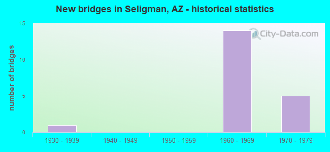
- New bridges - historical statistics
- 11930-1939
- 141960-1969
- 51970-1979
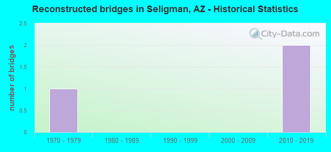
- Reconstructed bridges - Historical Statistics
- 11970-1979
- 01980-1989
- 01990-1999
- 02000-2009
- 22010-2019
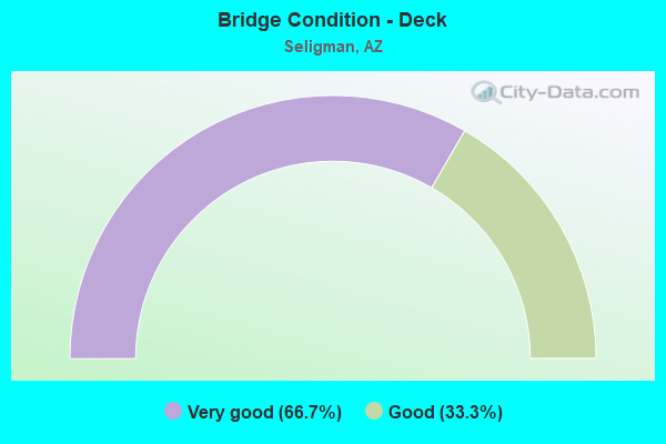
- Bridge Condition - Deck
- 66.7%Very good
- 33.3%Good
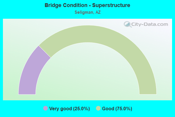
- Bridge Condition - Superstructure
- 25.0%Very good
- 75.0%Good
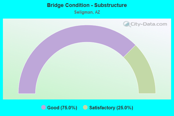
- Bridge Condition - Substructure
- 75.0%Good
- 25.0%Satisfactory
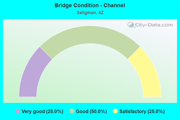
- Bridge Condition - Channel
- 25.0%Very good
- 50.0%Good
- 25.0%Satisfactory
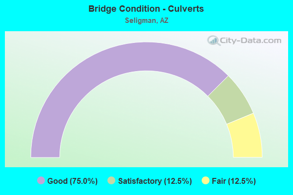
- Bridge Condition - Culverts
- 75.0%Good
- 12.5%Satisfactory
- 12.5%Fair
Find on map >> Show street view
Structure Number: 1007, Location: 0.8 mi N I 40/Exit 123 (Lat: 35.320000, Lng: -112.849600), Route carried "on" structure: County highway , Year Built: 1969, Status: Open, Structure Length: 3.05m (10.01ft), Average Daily Traffic: 1,009 (year 2020), Truck Traffic: 5%, Average Future Daily Traffic: 1,019 (year 2040), Design Load: HS 20, Features Intersected: SB 40, Facility Carried by Structure: County Road
Minimum Vertical Clearance: 30+ m (98+ ft), Kilometerpoint: 0.000, Lanes on structure: 2, Lanes under structure: 2, Owner: State Highway Agency, Approaching Roadway Width: 12.2m (40.0ft), Material/Design: Steel, Design/Construction: Stringer/Multi-beam, Number Of Spans In Main Unit: 1, Length of Maximum Span: 29.3m (96.1ft), Curb-To-Curb Width: 12.2m (40.0ft), Out-to-Out Width: 13.0m (42.7ft)
Condition: Deck: Good, Superstructure: Good, Substructure: Satisfactory, Operating Rating: 62.6 metric tons, Method Used To Determine Operating Rating: Load Factor (LF), Inventory Rating: 37.2 metric tons, Method Used To Determine Inventory Rating: Load Factor (LF), Structural Evaluation: Equal to present minimum criteria, Deck Geometry: Better than present minimum criteria, Underclear: Better than present minimum criteria, Approach Roadway Alignment: Equal to present desirable criteria, Designated Inspection Frequency: Every 24 months, Inspection Date: June 2020, Deck Structure Type: Concrete Cast-file-Place, Wearing Surface/Protective System: Wearing Surface: Monolithic Concrete
Find on map >> Show street view
Structure Number: 1273, Location: 0.8 mi N Jct I-40 (Lat: 35.319600, Lng: -112.849700), Route carried "on" structure: , Year Built: 1969, Status: Open, Structure Length: 2.53m (8.30ft), Design Load: Railroad, Features Intersected: 40B, Facility Carried by Structure: BNSF RR
Kilometerpoint: 0.000, Lanes under structure: 2, Owner: Railroad, Maintenance Responsibility: State Highway Agency, Material/Design: Steel, Design/Construction: Stringer/Multi-beam, Number Of Spans In Main Unit: 1, Length of Maximum Span: 23.8m (78.1ft), Curb or Sidewalk Widths: Left: 0.5m (1.6ft), Right: 0.5m (1.6ft), Out-to-Out Width: 10.5m (34.4ft)
Condition: Superstructure: Good, Substructure: Good, Operating Rating: 65.3 metric tons, Method Used To Determine Operating Rating: No rating analysis performed, Inventory Rating: 65.3 metric tons, Method Used To Determine Inventory Rating: No rating analysis performed, Structural Evaluation: Better than present minimum criteria, Underclear: Better than present minimum criteria, Designated Inspection Frequency: Every 24 months, Inspection Date: May 2020, Deck Structure Type: Concrete Cast-file-Place
Find on map >> Show street view
Structure Number: 1798, Location: 0.65 mi N Jct I-40 (Lat: 35.328500, Lng: -112.890500), Route carried "on" structure: Business State highway 40, Year Built: 1978, Year Reconstructed: 2019, Status: Open, Structure Length: 4.66m (15.29ft), Average Daily Traffic: 1,552 (year 2018), Truck Traffic: 7%, Average Future Daily Traffic: 1,562 (year 2038), Design Load: HS 20, Features Intersected: BNSF RR
Minimum Vertical Clearance: 30+ m (98+ ft), Kilometerpoint: 224.343, Lanes on structure: 2, Owner: State Highway Agency, Approaching Roadway Width: 12.2m (40.0ft), Material/Design: Prestressed concrete continuous, Design/Construction: Stringer/Multi-beam, Number Of Spans In Main Unit: 3, Length of Maximum Span: 17.1m (56.1ft), Curb-To-Curb Width: 13.4m (44.0ft), Out-to-Out Width: 14.4m (47.2ft)
Condition: Deck: Very good, Superstructure: Good, Substructure: Good, Operating Rating: 87.1 metric tons, Method Used To Determine Operating Rating: Load Factor (LF), Inventory Rating: 38.1 metric tons, Method Used To Determine Inventory Rating: Load Factor (LF), Structural Evaluation: Better than present minimum criteria, Deck Geometry: Equal to present desirable criteria, Underclear: Better than present minimum criteria, Approach Roadway Alignment: Equal to present minimum criteria, Designated Inspection Frequency: Every 24 months, Inspection Date: May 2020, Deck Structure Type: Concrete Cast-file-Place, Wearing Surface/Protective System: Wearing Surface: Monolithic Concrete
Find on map >> Show street view
Structure Number: 1799, Location: 0.7 mi N Jct I-40 (Lat: 35.329400, Lng: -112.890300), Route carried "on" structure: Business State highway 40, Year Built: 1978, Year Reconstructed: 2019, Status: Open, Structure Length: 5.36m (17.59ft), Average Daily Traffic: 1,562 (year 2018), Truck Traffic: 7%, Average Future Daily Traffic: 1,572 (year 2038), Design Load: HS 20, Features Intersected: Old SR 66
Minimum Vertical Clearance: 30+ m (98+ ft), Kilometerpoint: 224.423, Lanes on structure: 2, Lanes under structure: 2, Owner: State Highway Agency, Approaching Roadway Width: 13.4m (44.0ft), Material/Design: Prestressed concrete, Design/Construction: Stringer/Multi-beam, Number Of Spans In Main Unit: 3, Length of Maximum Span: 26.5m (86.9ft), Curb-To-Curb Width: 13.4m (44.0ft), Out-to-Out Width: 14.4m (47.2ft)
Condition: Deck: Very good, Superstructure: Very good, Substructure: Good, Operating Rating: 64.4 metric tons, Method Used To Determine Operating Rating: Load Factor (LF), Inventory Rating: 49.9 metric tons, Method Used To Determine Inventory Rating: Load Factor (LF), Structural Evaluation: Better than present minimum criteria, Deck Geometry: Equal to present desirable criteria, Underclear: Superior to present desirable criteria, Approach Roadway Alignment: Equal to present minimum criteria, Designated Inspection Frequency: Every 24 months, Inspection Date: May 2020, Deck Structure Type: Concrete Cast-file-Place, Wearing Surface/Protective System: Wearing Surface: Monolithic Concrete
Find on map >> Show street view
Structure Number: 4245, Location: 2.0 mi W Jct I 40 (Lat: 35.325100, Lng: -112.866900), Route carried "on" structure: Business State highway 40, Year Built: 1970, Status: Open, Structure Length: 1.95m (6.40ft), Average Daily Traffic: 1,531 (year 2017), Truck Traffic: 7%, Average Future Daily Traffic: 1,541 (year 2038), Design Load: HS 20, Features Intersected: Wash
Minimum Vertical Clearance: 30+ m (98+ ft), Kilometerpoint: 227.070, Lanes on structure: 2, Owner: State Highway Agency, Approaching Roadway Width: 12.2m (40.0ft), Material/Design: Concrete continuous, Design/Construction: Culvert, Number Of Spans In Main Unit: 6, Length of Maximum Span: 3.0m (9.8ft)
Condition: Channel: Satisfactory, Culverts: Good, Operating Rating: 59.9 metric tons, Method Used To Determine Operating Rating: Load Factor (LF), Inventory Rating: 36.3 metric tons, Method Used To Determine Inventory Rating: Load Factor (LF), Structural Evaluation: Better than present minimum criteria, Waterway Adequacy: Equal to present desirable criteria, Approach Roadway Alignment: Equal to present desirable criteria, Designated Inspection Frequency: Every 48 months, Inspection Date: June 2018
Find on map >> Show street view
Structure Number: 5891, Location: 1.6 mi E Jct B 40 (Lat: 35.297400, Lng: -112.833500), Route carried "on" structure: Interstate 40, Year Built: 1966, Status: Open, Structure Length: 2.26m (7.41ft), Average Daily Traffic: 7,919 (year 2017), Truck Traffic: 40%, Average Future Daily Traffic: 7,929 (year 2037), Design Load: HS 20, Features Intersected: Wash
Minimum Vertical Clearance: 30+ m (98+ ft), Kilometerpoint: 201.040, Lanes on structure: 2, Owner: State Highway Agency, Approaching Roadway Width: 11.6m (38.1ft), Skew: 13 degrees, Material/Design: Concrete continuous, Design/Construction: Culvert, Number Of Spans In Main Unit: 6, Length of Maximum Span: 3.7m (12.1ft)
Condition: Channel: Good, Culverts: Satisfactory, Operating Rating: 89.8 metric tons, Method Used To Determine Operating Rating: Load Factor (LF), Inventory Rating: 72.6 metric tons, Method Used To Determine Inventory Rating: Load Factor (LF), Structural Evaluation: Equal to present minimum criteria, Waterway Adequacy: Equal to present desirable criteria, Approach Roadway Alignment: Equal to present desirable criteria, Designated Inspection Frequency: Every 48 months, Inspection Date: June 2018
Find on map >> Show street view
Structure Number: 5892, Location: 1.6 mi E Jct B 40 (Lat: 35.297500, Lng: -112.833100), Route carried "on" structure: Interstate 40, Year Built: 1966, Status: Open, Structure Length: 2.26m (7.41ft), Average Daily Traffic: 7,956 (year 2017), Truck Traffic: 40%, Average Future Daily Traffic: 7,966 (year 2037), Design Load: HS 20, Features Intersected: Wash
Minimum Vertical Clearance: 30+ m (98+ ft), Kilometerpoint: 201.040, Lanes on structure: 2, Owner: State Highway Agency, Approaching Roadway Width: 11.6m (38.1ft), Skew: 3 degrees, Material/Design: Concrete continuous, Design/Construction: Culvert, Number Of Spans In Main Unit: 6, Length of Maximum Span: 3.7m (12.1ft)
Condition: Channel: Satisfactory, Culverts: Good, Operating Rating: 89.8 metric tons, Method Used To Determine Operating Rating: Load Factor (LF), Inventory Rating: 72.6 metric tons, Method Used To Determine Inventory Rating: Load Factor (LF), Structural Evaluation: Better than present minimum criteria, Waterway Adequacy: Equal to present desirable criteria, Approach Roadway Alignment: Equal to present desirable criteria, Designated Inspection Frequency: Every 48 months, Inspection Date: June 2018
Find on map >> Show street view
Structure Number: 6035, Location: 0.7 mi N of Jct I 40 (Lat: 35.316300, Lng: -112.850900), Route carried "on" structure: Business State highway 40, Year Built: 1968, Status: Open, Structure Length: 0.64m (2.10ft), Average Daily Traffic: 1,531 (year 2017), Truck Traffic: 7%, Average Future Daily Traffic: 1,541 (year 2038), Design Load: HS 20, Features Intersected: Wash
Minimum Vertical Clearance: 7.62m (25.00ft), Kilometerpoint: 229.180, Lanes on structure: 2, Owner: State Highway Agency, Approaching Roadway Width: 12.2m (40.0ft), Material/Design: Concrete continuous, Design/Construction: Culvert, Number Of Spans In Main Unit: 2, Length of Maximum Span: 3.0m (9.8ft)
Condition: Channel: Very good, Culverts: Good, Operating Rating: 60.8 metric tons, Method Used To Determine Operating Rating: Load Factor (LF), Inventory Rating: 36.3 metric tons, Method Used To Determine Inventory Rating: Load Factor (LF), Structural Evaluation: Better than present minimum criteria, Waterway Adequacy: Equal to present desirable criteria, Approach Roadway Alignment: Equal to present desirable criteria, Designated Inspection Frequency: Every 48 months, Inspection Date: June 2018
Find on map >> Show street view
Structure Number: 6686, Location: 0.6 mi W Jct B 40 (Lat: 35.325000, Lng: -112.875000), Route carried "on" structure: Interstate 40, Year Built: 1968, Year Reconstructed: 1978, Status: Open, Structure Length: 0.64m (2.10ft), Average Daily Traffic: 16,922 (year 2017), Truck Traffic: 24%, Average Future Daily Traffic: 16,932 (year 2037), Design Load: HS 20, Features Intersected: Wash
Minimum Vertical Clearance: 30+ m (98+ ft), Kilometerpoint: 197.550, Lanes on structure: 4, Owner: State Highway Agency, Approaching Roadway Width: 23.2m (76.1ft), Skew: 30 degrees, Material/Design: Concrete continuous, Design/Construction: Culvert, Number Of Spans In Main Unit: 2, Length of Maximum Span: 3.0m (9.8ft)
Condition: Channel: Good, Culverts: Good, Operating Rating: 60.8 metric tons, Method Used To Determine Operating Rating: Load Factor (LF), Inventory Rating: 36.3 metric tons, Method Used To Determine Inventory Rating: Load Factor (LF), Structural Evaluation: Better than present minimum criteria, Waterway Adequacy: Equal to present desirable criteria, Approach Roadway Alignment: Equal to present desirable criteria, Length Of Structure Improvement: 1.37m (4.49ft), Designated Inspection Frequency: Every 48 months, Inspection Date: June 2018, Bridge Improvement Cost: $1,000, Total Project Cost: $2,000
Find on map >> Show street view
Structure Number: 673, Location: 0.3 mi N of Jct I 40 (Lat: 35.323600, Lng: -112.891400), Route carried "on" structure: Business State highway 40, Year Built: 1978, Status: Open, Structure Length: 0.98m (3.22ft), Average Daily Traffic: 1,552 (year 2017), Truck Traffic: 7%, Average Future Daily Traffic: 1,562 (year 2038), Design Load: HS 20, Features Intersected: Drainage Wash
Minimum Vertical Clearance: 30+ m (98+ ft), Kilometerpoint: 223.870, Lanes on structure: 2, Owner: State Highway Agency, Approaching Roadway Width: 13.4m (44.0ft), Material/Design: Concrete continuous, Design/Construction: Culvert, Number Of Spans In Main Unit: 3, Length of Maximum Span: 3.0m (9.8ft)
Condition: Channel: Good, Culverts: Good, Operating Rating: 89.8 metric tons, Method Used To Determine Operating Rating: Load Factor (LF), Inventory Rating: 89.8 metric tons, Method Used To Determine Inventory Rating: Load Factor (LF), Structural Evaluation: Better than present minimum criteria, Waterway Adequacy: Equal to present desirable criteria, Approach Roadway Alignment: Equal to present desirable criteria, Designated Inspection Frequency: Every 48 months, Inspection Date: June 2018
Find on map >> Show street view
Structure Number: 7758, Location: 0.5 mi W of Jct I 40 (Lat: 35.330500, Lng: -112.895861), Route carried "on" structure: County highway , Year Built: 1965, Status: Open, Structure Length: 0.76m (2.49ft), Average Daily Traffic: 1,485 (year 2019), Truck Traffic: 7%, Average Future Daily Traffic: 1,495 (year 2039), Design Load: HS 20, Features Intersected: Wash, Facility Carried by Structure: Old 66
Minimum Vertical Clearance: 30+ m (98+ ft), Kilometerpoint: 0.000, Lanes on structure: 2, Owner: County Highway Agency, Approaching Roadway Width: 12.5m (41.0ft), Material/Design: Concrete continuous, Design/Construction: Culvert, Number Of Spans In Main Unit: 2, Length of Maximum Span: 3.7m (12.1ft)
Condition: Channel: Very good, Culverts: Good, Operating Rating: 89.8 metric tons, Method Used To Determine Operating Rating: Load Factor (LF), Inventory Rating: 89.8 metric tons, Method Used To Determine Inventory Rating: Load Factor (LF), Structural Evaluation: Better than present minimum criteria, Waterway Adequacy: Equal to present desirable criteria, Approach Roadway Alignment: Equal to present desirable criteria, Designated Inspection Frequency: Every 48 months, Inspection Date: July 2019
Find on map >> Show street view
Structure Number: 8933, Location: 0.1 mi SE Jct B40 (Lat: 35.324600, Lng: -112.867100), Route carried "on" structure: County highway , Year Built: 1931, Status: Open, Structure Length: 1.95m (6.40ft), Average Daily Traffic: 382 (year 2019), Truck Traffic: 1%, Average Future Daily Traffic: 392 (year 2041), Design Load: H 15, Features Intersected: Wash, Facility Carried by Structure: Crookton Rd
Minimum Vertical Clearance: 30+ m (98+ ft), Kilometerpoint: 0.000, Lanes on structure: 1, Owner: County Highway Agency, Approaching Roadway Width: 6.1m (20.0ft), Material/Design: Concrete continuous, Design/Construction: Culvert, Number Of Spans In Main Unit: 6, Length of Maximum Span: 3.0m (9.8ft), Curb or Sidewalk Widths: Left: 0.3m (1.0ft), Right: 0.3m (1.0ft), Curb-To-Curb Width: 7.3m (24.0ft), Out-to-Out Width: 8.0m (26.2ft)
Condition: Channel: Good, Culverts: Fair, Operating Rating: 48.1 metric tons, Method Used To Determine Operating Rating: Load Factor (LF), Inventory Rating: 29.0 metric tons, Method Used To Determine Inventory Rating: Load Factor (LF), Structural Evaluation: Somewhat better than minimum adequacy, Deck Geometry: Somewhat better than minimum adequacy, Waterway Adequacy: Equal to present desirable criteria, Approach Roadway Alignment: Equal to present desirable criteria, Designated Inspection Frequency: Every 24 months, Inspection Date: July 2021, Deck Structure Type: Concrete Cast-file-Place, Wearing Surface/Protective System: Wearing Surface: Bituminous
Find on map >> Show street view
Structure Number: 1007, Location: 0.8 mi N I 40/Exit 123 (Lat: 35.320000, Lng: -112.849600), Route carried "under" structure: Business State highway 40, Year Built: 1969, Structure Length: 0. m, Average Daily Traffic: 1,136 (year 2019), Truck Traffic: 7%, Features Intersected: SB 40, Facility Carried by Structure: County Road
Minimum Vertical Clearance: 4.90m (16.08ft), Kilometerpoint: 228.849, Lanes on structure: 2, Lanes under structure: 2, Material/Design: Steel, Design/Construction: Stringer/Multi-beam, Length of Maximum Span: 29.3m (96.1ft)
Find on map >> Show street view
Structure Number: 1256, Location: 45.9 mi E Jct US 93 (Lat: 35.319400, Lng: -112.949100), Route carried "under" structure: Interstate 40, Year Built: 1968, Structure Length: 0. m, Average Daily Traffic: 7,763 (year 2019), Truck Traffic: 23%, Features Intersected: I 40 EB, Facility Carried by Structure: Cyn Mouth Dam Rd
Minimum Vertical Clearance: 4.98m (16.34ft), Kilometerpoint: 189.693, Lanes on structure: 2, Lanes under structure: 2, Material/Design: Steel, Design/Construction: Stringer/Multi-beam, Length of Maximum Span: 29.9m (98.1ft)
Find on map >> Show street view
Structure Number: 1257, Location: 45.9 mi E Jct US 93 (Lat: 35.319900, Lng: -112.949200), Route carried "under" structure: Interstate 40, Year Built: 1968, Structure Length: 0. m, Average Daily Traffic: 6,882 (year 2019), Truck Traffic: 24%, Features Intersected: I 40 WB, Facility Carried by Structure: Cyn Mouth Dam Rd
Minimum Vertical Clearance: 5.03m (16.50ft), Kilometerpoint: 189.693, Lanes on structure: 2, Lanes under structure: 2, Material/Design: Steel, Design/Construction: Stringer/Multi-beam, Length of Maximum Span: 29.9m (98.1ft)
Find on map >> Show street view
Structure Number: 1258, Location: 49.1 mi E Jct US 93 (Lat: 35.319900, Lng: -112.893400), Route carried "under" structure: Interstate 40, Year Built: 1967, Structure Length: 0. m, Average Daily Traffic: 16,905 (year 2017), Truck Traffic: 26%, Features Intersected: I-40
Minimum Vertical Clearance: 5.09m (16.70ft), Kilometerpoint: 194.843, Lanes on structure: 2, Lanes under structure: 2, Material/Design: Concrete continuous, Design/Construction: Box Beam or Girders - Single/Spread, Length of Maximum Span: 30.5m (100.1ft)
Find on map >> Show street view
Structure Number: 1259, Location: Jct 40B at Seligman (Lat: 35.310300, Lng: -112.856100), Route carried "under" structure: Business State highway 40, Year Built: 1967, Structure Length: 0. m, Average Daily Traffic: 1,200 (year 2020), Truck Traffic: 30%, Features Intersected: 40B
Minimum Vertical Clearance: 5.40m (17.72ft), Kilometerpoint: 230.072, Lanes on structure: 2, Lanes under structure: 2, Material/Design: Concrete continuous, Design/Construction: Slab, Length of Maximum Span: 12.2m (40.0ft)
Find on map >> Show street view
Structure Number: 126, Location: Jct 40B at Seligman (Lat: 35.310500, Lng: -112.855800), Route carried "under" structure: Business State highway 40, Year Built: 1967, Structure Length: 0. m, Average Daily Traffic: 1,200 (year 2020), Truck Traffic: 10%, Features Intersected: 40B
Minimum Vertical Clearance: 5.14m (16.86ft), Kilometerpoint: 230.040, Lanes on structure: 2, Lanes under structure: 2, Material/Design: Concrete continuous, Design/Construction: Slab, Length of Maximum Span: 12.2m (40.0ft)
Find on map >> Show street view
Structure Number: 1273, Location: 0.8 mi N Jct I-40 (Lat: 35.319600, Lng: -112.849700), Route carried "under" structure: Business State highway 40, Year Built: 1969, Structure Length: 0. m, Average Daily Traffic: 1,531 (year 2017), Truck Traffic: 7%, Features Intersected: 40B, Facility Carried by Structure: BNSF RR
Minimum Vertical Clearance: 4.79m (15.72ft), Kilometerpoint: 228.865, Lanes under structure: 2, Material/Design: Steel, Design/Construction: Stringer/Multi-beam, Length of Maximum Span: 23.8m (78.1ft)
Find on map >> Show street view
Structure Number: 1799, Location: 0.7 mi N Jct I-40 (Lat: 35.329400, Lng: -112.890300), Route carried "under" structure: County highway , Year Built: 1978, Structure Length: 0. m, Average Daily Traffic: 510 (year 2018), Truck Traffic: 4%, Features Intersected: Old SR 66, Facility Carried by Structure: 40B
Minimum Vertical Clearance: 5.41m (17.75ft), Kilometerpoint: 0.000, Lanes on structure: 2, Lanes under structure: 2, Material/Design: Prestressed concrete, Design/Construction: Stringer/Multi-beam, Length of Maximum Span: 26.5m (86.9ft)