Bridge Statistics for Sells, Arizona (AZ)
Condition, Traffic, Stress, Structural Evaluation, Project Costs
- National Bridge Inventory (NBI) Statistics
- 19Number of bridges
- 128ft / 39.5mTotal length
- $200,000Total costs
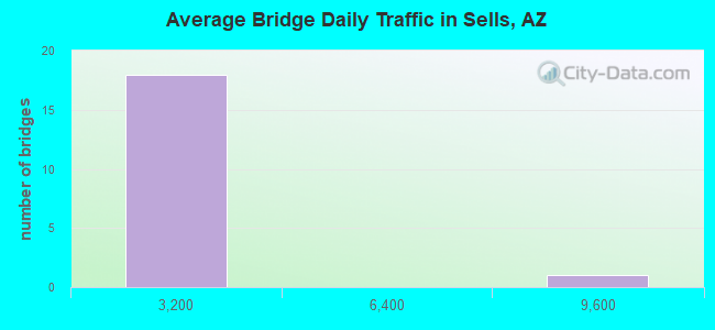
- 23,852Total average daily traffic
- 2,139Total average daily truck traffic
- 26,179Total future (year 2038) average daily traffic
- National Bridge Inventory (NBI) Registered Bridges for Sells
- No street view available for this location
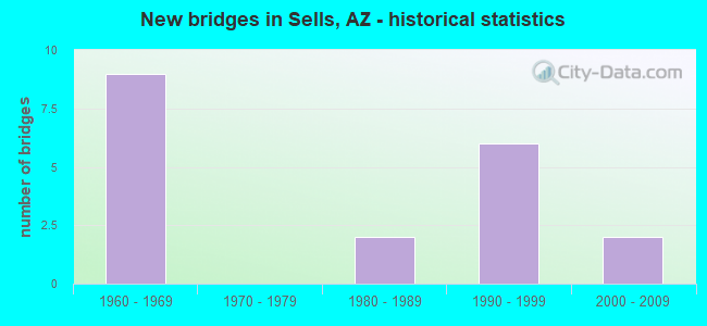
- New bridges - historical statistics
- 91960-1969
- 21980-1989
- 61990-1999
- 22000-2009
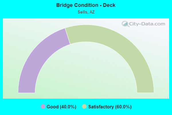
- Bridge Condition - Deck
- 40.0%Good
- 60.0%Satisfactory
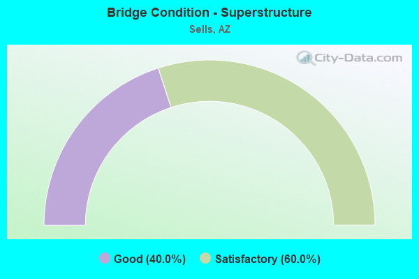
- Bridge Condition - Superstructure
- 40.0%Good
- 60.0%Satisfactory
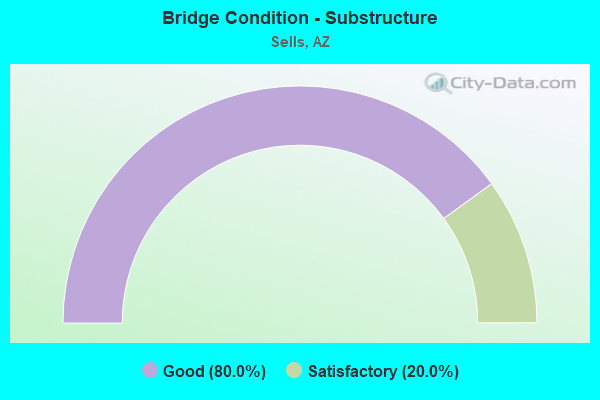
- Bridge Condition - Substructure
- 80.0%Good
- 20.0%Satisfactory
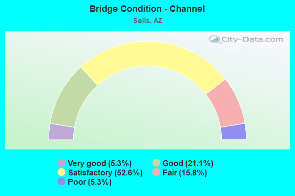
- Bridge Condition - Channel
- 5.3%Very good
- 21.1%Good
- 52.6%Satisfactory
- 15.8%Fair
- 5.3%Poor
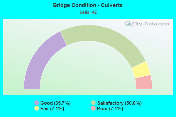
- Bridge Condition - Culverts
- 35.7%Good
- 50.0%Satisfactory
- 7.1%Fair
- 7.1%Poor
Find on map >> Show street view
Structure Number: H614, Location: 4.7 KM SOUTH OF AZ HWY 86 (Lat: 31.884914, Lng: -111.871508), Route carried "on" structure: Federal lands road 19, Year Built: 1962, Status: Open, Structure Length: 0.97m (3.18ft), Average Daily Traffic: 950 (year 2021), Truck Traffic: 4%, Average Future Daily Traffic: 1,112 (year 2041), Design Load: HS 20, Features Intersected: WASH
Minimum Vertical Clearance: 30+ m (98+ ft), Kilometerpoint: 4.600, Lanes on structure: 2, Owner: Bureau of Indian Affairs, Approaching Roadway Width: 7.9m (25.9ft), Material/Design: Concrete continuous, Design/Construction: Culvert, Number Of Spans In Main Unit: 3, Length of Maximum Span: 3.1m (10.2ft), Curb or Sidewalk Widths: Left: 0.3m (1.0ft), Right: 0.3m (1.0ft), Curb-To-Curb Width: 7.9m (25.9ft), Out-to-Out Width: 11.5m (37.7ft)
Condition: Channel: Satisfactory, Culverts: Satisfactory, Operating Rating: 44.5 metric tons, Method Used To Determine Operating Rating: Allowable Stress (AS), Inventory Rating: 32.7 metric tons, Method Used To Determine Inventory Rating: Allowable Stress (AS), Structural Evaluation: Equal to present minimum criteria, Deck Geometry: Somewhat better than minimum adequacy, Waterway Adequacy: Equal to present desirable criteria, Approach Roadway Alignment: Equal to present desirable criteria, Designated Inspection Frequency: Every 24 months, Inspection Date: June 2021
Find on map >> Show street view
Structure Number: H615, Location: 9.2 KM SOUTH OF AZ HWY 86 (Lat: 31.848153, Lng: -111.849275), Route carried "on" structure: Federal lands road 19, Year Built: 1962, Status: Open, Structure Length: 0.64m (2.10ft), Average Daily Traffic: 950 (year 2021), Truck Traffic: 4%, Average Future Daily Traffic: 1,112 (year 2041), Design Load: HS 20, Features Intersected: WASH
Minimum Vertical Clearance: 30+ m (98+ ft), Kilometerpoint: 9.173, Lanes on structure: 2, Owner: Bureau of Indian Affairs, Approaching Roadway Width: 7.8m (25.6ft), Material/Design: Concrete continuous, Design/Construction: Culvert, Number Of Spans In Main Unit: 2, Length of Maximum Span: 3.1m (10.2ft), Curb or Sidewalk Widths: Left: 0.3m (1.0ft), Right: 0.3m (1.0ft), Curb-To-Curb Width: 7.8m (25.6ft), Out-to-Out Width: 7.8m (25.6ft)
Condition: Channel: Fair, Culverts: Satisfactory, Operating Rating: 44.5 metric tons, Method Used To Determine Operating Rating: Allowable Stress (AS), Inventory Rating: 32.7 metric tons, Method Used To Determine Inventory Rating: Allowable Stress (AS), Structural Evaluation: Equal to present minimum criteria, Deck Geometry: Meets minimum limits, Waterway Adequacy: Better than present minimum criteria, Approach Roadway Alignment: Equal to present desirable criteria, Designated Inspection Frequency: Every 24 months, Inspection Date: June 2021, Deck Structure Type: Concrete Cast-file-Place, Wearing Surface/Protective System: Wearing Surface: Bituminous
Find on map >> Show street view
Structure Number: H616, Location: 11.5 KM S OF AZ HWY 86 (Lat: 31.830083, Lng: -111.837583), Route carried "on" structure: Federal lands road 19, Year Built: 1962, Status: Open, Structure Length: 4.29m (14.07ft), Average Daily Traffic: 950 (year 2021), Truck Traffic: 4%, Average Future Daily Traffic: 1,112 (year 2041), Design Load: HS 20, Features Intersected: FRESNAL WASH
Minimum Vertical Clearance: 30+ m (98+ ft), Kilometerpoint: 11.490, Lanes on structure: 2, Owner: Bureau of Indian Affairs, Approaching Roadway Width: 8.4m (27.6ft), Material/Design: Concrete continuous, Design/Construction: Slab, Number Of Spans In Main Unit: 5, Length of Maximum Span: 9.2m (30.2ft), Curb or Sidewalk Widths: Left: 0.4m (1.3ft), Right: 0.4m (1.3ft), Curb-To-Curb Width: 8.6m (28.2ft), Out-to-Out Width: 9.3m (30.5ft)
Condition: Deck: Satisfactory, Superstructure: Satisfactory, Substructure: Good, Channel: Satisfactory, Operating Rating: 44.5 metric tons, Method Used To Determine Operating Rating: Allowable Stress (AS), Inventory Rating: 32.6 metric tons, Method Used To Determine Inventory Rating: Allowable Stress (AS), Structural Evaluation: Equal to present minimum criteria, Deck Geometry: Somewhat better than minimum adequacy, Waterway Adequacy: Equal to present minimum criteria, Approach Roadway Alignment: Equal to present desirable criteria, Designated Inspection Frequency: Every 24 months, Inspection Date: June 2021, Deck Structure Type: Concrete Cast-file-Place, Wearing Surface/Protective System: Wearing Surface: Monolithic Concrete
Find on map >> Show street view
Structure Number: H617, Location: 13.5 KM S OF AZ HWY 86 (Lat: 31.815028, Lng: -111.826944), Route carried "on" structure: Federal lands road 19, Year Built: 1962, Status: Open, Structure Length: 0.65m (2.13ft), Average Daily Traffic: 950 (year 2021), Truck Traffic: 4%, Average Future Daily Traffic: 1,112 (year 2041), Design Load: HS 20, Features Intersected: WASH
Minimum Vertical Clearance: 30+ m (98+ ft), Kilometerpoint: 13.440, Lanes on structure: 2, Owner: Bureau of Indian Affairs, Approaching Roadway Width: 7.6m (24.9ft), Material/Design: Concrete continuous, Design/Construction: Culvert, Number Of Spans In Main Unit: 2, Length of Maximum Span: 3.1m (10.2ft), Curb or Sidewalk Widths: Left: 0.3m (1.0ft), Right: 0.3m (1.0ft), Curb-To-Curb Width: 10.6m (34.8ft), Out-to-Out Width: 13.6m (44.6ft)
Condition: Channel: Satisfactory, Culverts: Satisfactory, Operating Rating: 44.2 metric tons, Method Used To Determine Operating Rating: Allowable Stress (AS), Inventory Rating: 32.4 metric tons, Method Used To Determine Inventory Rating: Allowable Stress (AS), Structural Evaluation: Equal to present minimum criteria, Deck Geometry: Equal to present minimum criteria, Waterway Adequacy: Better than present minimum criteria, Approach Roadway Alignment: Equal to present desirable criteria, Designated Inspection Frequency: Every 24 months, Inspection Date: June 2021
Find on map >> Show street view
Structure Number: H618, Location: 19.5 KM S OF AZ HWY 86 (Lat: 31.767583, Lng: -111.795556), Route carried "on" structure: Federal lands road 19, Year Built: 1962, Status: Open, Structure Length: 0.64m (2.10ft), Average Daily Traffic: 950 (year 2021), Truck Traffic: 4%, Average Future Daily Traffic: 1,112 (year 2041), Design Load: HS 20, Features Intersected: WASH
Minimum Vertical Clearance: 30+ m (98+ ft), Kilometerpoint: 19.500, Lanes on structure: 2, Owner: Bureau of Indian Affairs, Approaching Roadway Width: 10.6m (34.8ft), Material/Design: Concrete continuous, Design/Construction: Culvert, Number Of Spans In Main Unit: 2, Length of Maximum Span: 3.1m (10.2ft), Curb or Sidewalk Widths: Left: 0.3m (1.0ft), Right: 0.3m (1.0ft), Curb-To-Curb Width: 10.6m (34.8ft), Out-to-Out Width: 12.1m (39.7ft)
Condition: Channel: Satisfactory, Culverts: Satisfactory, Operating Rating: 44.5 metric tons, Method Used To Determine Operating Rating: Allowable Stress (AS), Inventory Rating: 32.6 metric tons, Method Used To Determine Inventory Rating: Allowable Stress (AS), Structural Evaluation: Equal to present minimum criteria, Deck Geometry: Equal to present minimum criteria, Waterway Adequacy: Equal to present minimum criteria, Approach Roadway Alignment: Equal to present desirable criteria, Designated Inspection Frequency: Every 24 months, Inspection Date: June 2021
Find on map >> Show street view
Structure Number: H623, Location: 24.7 KM S OF AZ HWY 86 (Lat: 31.723306, Lng: -111.781361), Route carried "on" structure: Federal lands road 19, Year Built: 1989, Status: Open, Structure Length: 3.84m (12.60ft), Average Daily Traffic: 950 (year 2021), Truck Traffic: 4%, Average Future Daily Traffic: 1,054 (year 2041), Design Load: HS 20, Features Intersected: CHUTYM VAYA WASH
Minimum Vertical Clearance: 30+ m (98+ ft), Kilometerpoint: 24.620, Lanes on structure: 2, Owner: Bureau of Indian Affairs, Approaching Roadway Width: 8.6m (28.2ft), Material/Design: Concrete continuous, Design/Construction: Slab, Number Of Spans In Main Unit: 4, Length of Maximum Span: 10.4m (34.1ft), Curb or Sidewalk Widths: Left: 0.5m (1.6ft), Right: 0.5m (1.6ft), Curb-To-Curb Width: 9.7m (31.8ft), Out-to-Out Width: 10.7m (35.1ft)
Condition: Deck: Satisfactory, Superstructure: Satisfactory, Substructure: Good, Channel: Good, Operating Rating: 47.7 metric tons, Method Used To Determine Operating Rating: Allowable Stress (AS), Inventory Rating: 36.0 metric tons, Method Used To Determine Inventory Rating: Allowable Stress (AS), Structural Evaluation: Equal to present minimum criteria, Deck Geometry: Equal to present minimum criteria, Waterway Adequacy: Better than present minimum criteria, Approach Roadway Alignment: Equal to present desirable criteria, Designated Inspection Frequency: Every 24 months, Inspection Date: June 2021, Deck Structure Type: Concrete Cast-file-Place, Wearing Surface/Protective System: Wearing Surface: Monolithic Concrete
Find on map >> Show street view
Structure Number: H624, Location: 27.7 KM S OF AZ HWY 86 (Lat: 31.686083, Lng: -111.771972), Route carried "on" structure: Federal lands road 19, Year Built: 1989, Status: Open, Structure Length: 2.47m (8.10ft), Average Daily Traffic: 950 (year 2021), Truck Traffic: 4%, Average Future Daily Traffic: 1,054 (year 2041), Design Load: HS 20, Features Intersected: SUPI OIDAK WASH
Minimum Vertical Clearance: 30+ m (98+ ft), Kilometerpoint: 15.932, Lanes on structure: 2, Owner: Bureau of Indian Affairs, Approaching Roadway Width: 8.1m (26.6ft), Material/Design: Concrete continuous, Design/Construction: Slab, Number Of Spans In Main Unit: 3, Length of Maximum Span: 9.1m (29.9ft), Curb or Sidewalk Widths: Left: 0.5m (1.6ft), Right: 0.5m (1.6ft), Curb-To-Curb Width: 9.7m (31.8ft), Out-to-Out Width: 10.7m (35.1ft)
Condition: Deck: Satisfactory, Superstructure: Satisfactory, Substructure: Good, Channel: Very good, Operating Rating: 44.3 metric tons, Method Used To Determine Operating Rating: Allowable Stress (AS), Inventory Rating: 32.4 metric tons, Method Used To Determine Inventory Rating: Allowable Stress (AS), Structural Evaluation: Equal to present minimum criteria, Deck Geometry: Equal to present minimum criteria, Waterway Adequacy: Equal to present desirable criteria, Approach Roadway Alignment: Equal to present desirable criteria, Designated Inspection Frequency: Every 24 months, Inspection Date: June 2021, Deck Structure Type: Concrete Cast-file-Place, Wearing Surface/Protective System: Wearing Surface: Monolithic Concrete
Find on map >> Show street view
Structure Number: H627, Location: 0.5 KM SOUTH OF AZ HWY 86 (Lat: 31.916528, Lng: -111.889194), Route carried "on" structure: Federal lands road 19, Year Built: 1995, Status: Open, Structure Length: 9.15m (30.02ft), Average Daily Traffic: 1,530 (year 2021), Truck Traffic: 10%, Average Future Daily Traffic: 1,815 (year 2041), Design Load: HS 20, Features Intersected: SELLS WASH
Minimum Vertical Clearance: 30+ m (98+ ft), Kilometerpoint: 0.500, Lanes on structure: 2, Owner: Bureau of Indian Affairs, Approaching Roadway Width: 11.6m (38.1ft), Material/Design: Prestressed concrete, Design/Construction: Box Beam or Girders - Multiple, Number Of Spans In Main Unit: 6, Length of Maximum Span: 14.8m (48.6ft), Curb or Sidewalk Widths: Left: 2.1m (6.9ft), Right: 2.1m (6.9ft), Curb-To-Curb Width: 11.5m (37.7ft), Out-to-Out Width: 15.8m (51.8ft)
Condition: Deck: Good, Superstructure: Good, Substructure: Satisfactory, Channel: Satisfactory, Operating Rating: 44.2 metric tons, Method Used To Determine Operating Rating: Allowable Stress (AS), Inventory Rating: 32.4 metric tons, Method Used To Determine Inventory Rating: Allowable Stress (AS), Structural Evaluation: Equal to present minimum criteria, Deck Geometry: Equal to present minimum criteria, Waterway Adequacy: Better than present minimum criteria, Approach Roadway Alignment: Equal to present desirable criteria, Designated Inspection Frequency: Every 24 months, Inspection Date: June 2021, Deck Structure Type: Concrete Precast Panels, Wearing Surface/Protective System: Wearing Surface: Bituminous, Membrane: Preformed Fabric
Find on map >> Show street view
Structure Number: H628, Location: 4.2 KM SE OF SELLS (Lat: 31.906667, Lng: -111.841667), Route carried "on" structure: Federal lands road 16, Year Built: 1998, Status: Open, Structure Length: 0.88m (2.89ft), Average Daily Traffic: 166 (year 2021), Truck Traffic: 2%, Average Future Daily Traffic: 194 (year 2041), Design Load: HS 20, Features Intersected: WASH
Minimum Vertical Clearance: 30+ m (98+ ft), Kilometerpoint: 4.120, Lanes on structure: 2, Owner: Bureau of Indian Affairs, Approaching Roadway Width: 8.8m (28.9ft), Material/Design: Aluminum, Iron, Design/Construction: Culvert, Number Of Spans In Main Unit: 2, Length of Maximum Span: 3.9m (12.8ft), Curb-To-Curb Width: 8.8m (28.9ft), Out-to-Out Width: 9.6m (31.5ft)
Condition: Channel: Satisfactory, Culverts: Good, Operating Rating: 44.2 metric tons, Method Used To Determine Operating Rating: Allowable Stress (AS), Inventory Rating: 32.4 metric tons, Method Used To Determine Inventory Rating: Allowable Stress (AS), Structural Evaluation: Better than present minimum criteria, Deck Geometry: Equal to present minimum criteria, Waterway Adequacy: Better than present minimum criteria, Approach Roadway Alignment: Equal to present desirable criteria, Designated Inspection Frequency: Every 24 months, Inspection Date: June 2021
Find on map >> Show street view
Structure Number: H629, Location: 4 KM SE OF SELLS (Lat: 31.906750, Lng: -111.842017), Route carried "on" structure: Federal lands road 16, Year Built: 1998, Status: Open, Structure Length: 0.70m (2.30ft), Average Daily Traffic: 166 (year 2021), Truck Traffic: 2%, Average Future Daily Traffic: 194 (year 2041), Design Load: HS 20, Features Intersected: WASH
Minimum Vertical Clearance: 30+ m (98+ ft), Kilometerpoint: 4.000, Lanes on structure: 2, Owner: Bureau of Indian Affairs, Approaching Roadway Width: 8.4m (27.6ft), Material/Design: Aluminum, Iron, Design/Construction: Culvert, Number Of Spans In Main Unit: 2, Length of Maximum Span: 3.1m (10.2ft), Curb-To-Curb Width: 8.8m (28.9ft), Out-to-Out Width: 9.6m (31.5ft)
Condition: Channel: Satisfactory, Culverts: Good, Operating Rating: 44.2 metric tons, Method Used To Determine Operating Rating: Allowable Stress (AS), Inventory Rating: 32.4 metric tons, Method Used To Determine Inventory Rating: Allowable Stress (AS), Structural Evaluation: Better than present minimum criteria, Deck Geometry: Equal to present minimum criteria, Waterway Adequacy: Better than present minimum criteria, Approach Roadway Alignment: Equal to present desirable criteria, Designated Inspection Frequency: Every 24 months, Inspection Date: June 2021
Find on map >> Show street view
Structure Number: H63, Location: 2.3 KM SE OF SELLS (Lat: 31.901422, Lng: -111.854678), Route carried "on" structure: Federal lands road 16, Year Built: 1998, Status: Open, Structure Length: 0.63m (2.07ft), Average Daily Traffic: 166 (year 2021), Truck Traffic: 2%, Average Future Daily Traffic: 194 (year 2041), Design Load: HS 20, Features Intersected: WASH
Minimum Vertical Clearance: 30+ m (98+ ft), Kilometerpoint: 2.240, Lanes on structure: 2, Owner: Bureau of Indian Affairs, Approaching Roadway Width: 8.9m (29.2ft), Material/Design: Steel, Design/Construction: Culvert, Number Of Spans In Main Unit: 3, Length of Maximum Span: 1.5m (4.9ft), Curb-To-Curb Width: 8.9m (29.2ft), Out-to-Out Width: 9.8m (32.2ft)
Condition: Channel: Poor, Culverts: Good, Operating Rating: 44.5 metric tons, Method Used To Determine Operating Rating: Allowable Stress (AS), Inventory Rating: 32.7 metric tons, Method Used To Determine Inventory Rating: Allowable Stress (AS), Structural Evaluation: Better than present minimum criteria, Deck Geometry: Equal to present minimum criteria, Waterway Adequacy: Better than present minimum criteria, Approach Roadway Alignment: Equal to present desirable criteria, Designated Inspection Frequency: Every 24 months, Inspection Date: June 2021
Find on map >> Show street view
Structure Number: H631, Location: 1.5 KM SE OF SELLS (Lat: 31.906656, Lng: -111.860331), Route carried "on" structure: Federal lands road 16, Year Built: 1998, Status: Open, Structure Length: 0.92m (3.02ft), Average Daily Traffic: 166 (year 2021), Truck Traffic: 2%, Average Future Daily Traffic: 194 (year 2041), Design Load: HS 20, Features Intersected: WASH
Minimum Vertical Clearance: 30+ m (98+ ft), Kilometerpoint: 1.460, Lanes on structure: 2, Owner: Bureau of Indian Affairs, Approaching Roadway Width: 8.9m (29.2ft), Skew: 4 degrees, Material/Design: Aluminum, Iron, Design/Construction: Culvert, Number Of Spans In Main Unit: 2, Length of Maximum Span: 4.1m (13.5ft), Curb-To-Curb Width: 8.9m (29.2ft), Out-to-Out Width: 9.8m (32.2ft)
Condition: Channel: Satisfactory, Culverts: Good, Operating Rating: 44.5 metric tons, Method Used To Determine Operating Rating: Allowable Stress (AS), Inventory Rating: 32.7 metric tons, Method Used To Determine Inventory Rating: Allowable Stress (AS), Structural Evaluation: Better than present minimum criteria, Deck Geometry: Equal to present minimum criteria, Waterway Adequacy: Better than present minimum criteria, Approach Roadway Alignment: Equal to present desirable criteria, Designated Inspection Frequency: Every 24 months, Inspection Date: June 2021
Find on map >> Show street view
Structure Number: H632, Location: 0.3 KM SOUTH OF AZ HWY 86 (Lat: 31.916050, Lng: -111.879731), Route carried "on" structure: Federal lands road 101, Year Built: 1965, Year Reconstructed: 1995, Status: Open, Structure Length: 2.19m (7.19ft), Average Daily Traffic: 1,100 (year 2021), Truck Traffic: 10%, Average Future Daily Traffic: 1,285 (year 2041), Design Load: HS 20, Features Intersected: ALI MOLINA WASH
Minimum Vertical Clearance: 30+ m (98+ ft), Kilometerpoint: 0.280, Lanes on structure: 2, Owner: Bureau of Indian Affairs, Approaching Roadway Width: 8.6m (28.2ft), Skew: 4 degrees, Material/Design: Concrete continuous, Design/Construction: Culvert, Number Of Spans In Main Unit: 4, Length of Maximum Span: 5.1m (16.7ft), Curb or Sidewalk Widths: Left: 0.5m (1.6ft), Right: 1.8m (5.9ft), Curb-To-Curb Width: 8.6m (28.2ft), Out-to-Out Width: 10.5m (34.4ft)
Condition: Channel: Satisfactory, Culverts: Fair, Operating Rating: 44.5 metric tons, Method Used To Determine Operating Rating: Allowable Stress (AS), Inventory Rating: 32.7 metric tons, Method Used To Determine Inventory Rating: Allowable Stress (AS), Structural Evaluation: Somewhat better than minimum adequacy, Deck Geometry: Somewhat better than minimum adequacy, Waterway Adequacy: Equal to present minimum criteria, Approach Roadway Alignment: Equal to present desirable criteria, Designated Inspection Frequency: Every 24 months, Inspection Date: June 2021, Deck Structure Type: Concrete Cast-file-Place, Wearing Surface/Protective System: Wearing Surface: Bituminous
Find on map >> Show street view
Structure Number: H633, Location: 1.4 KM NORTH OF AZ HWY 86 (Lat: 32.171917, Lng: -112.109333), Route carried "on" structure: Federal lands road 15, Year Built: 1965, Status: Open, Structure Length: 0.64m (2.10ft), Average Daily Traffic: 1,100 (year 2021), Truck Traffic: 4%, Average Future Daily Traffic: 1,320 (year 2041), Design Load: HS 20, Features Intersected: WASH
Minimum Vertical Clearance: 30+ m (98+ ft), Kilometerpoint: 1.360, Lanes on structure: 2, Owner: Bureau of Indian Affairs, Approaching Roadway Width: 10.9m (35.8ft), Material/Design: Concrete continuous, Design/Construction: Culvert, Number Of Spans In Main Unit: 2, Length of Maximum Span: 3.1m (10.2ft), Curb or Sidewalk Widths: Left: 0.3m (1.0ft), Right: 0.3m (1.0ft), Curb-To-Curb Width: 10.9m (35.8ft), Out-to-Out Width: 18.9m (62.0ft)
Condition: Channel: Fair, Culverts: Satisfactory, Operating Rating: 44.5 metric tons, Method Used To Determine Operating Rating: Allowable Stress (AS), Inventory Rating: 32.6 metric tons, Method Used To Determine Inventory Rating: Allowable Stress (AS), Structural Evaluation: Equal to present minimum criteria, Deck Geometry: Equal to present minimum criteria, Waterway Adequacy: Equal to present minimum criteria, Approach Roadway Alignment: Equal to present desirable criteria, Designated Inspection Frequency: Every 24 months, Inspection Date: June 2021, Deck Structure Type: Concrete Cast-file-Place, Wearing Surface/Protective System: Wearing Surface: Bituminous
Find on map >> Show street view
Structure Number: H634, Location: 5 KM NORTH OF AZ HWY 86 (Lat: 32.202500, Lng: -112.098778), Route carried "on" structure: Federal lands road 15, Year Built: 1965, Status: Open, Structure Length: 0.74m (2.43ft), Average Daily Traffic: 1,100 (year 2021), Truck Traffic: 4%, Average Future Daily Traffic: 1,320 (year 2041), Design Load: HS 20, Features Intersected: WASH
Minimum Vertical Clearance: 30+ m (98+ ft), Kilometerpoint: 4.970, Lanes on structure: 2, Owner: Bureau of Indian Affairs, Approaching Roadway Width: 10.9m (35.8ft), Skew: 3 degrees, Material/Design: Concrete continuous, Design/Construction: Culvert, Number Of Spans In Main Unit: 2, Length of Maximum Span: 3.5m (11.5ft), Curb or Sidewalk Widths: Left: 0.3m (1.0ft), Right: 0.3m (1.0ft), Curb-To-Curb Width: 10.9m (35.8ft), Out-to-Out Width: 14.6m (47.9ft)
Condition: Channel: Good, Culverts: Satisfactory, Operating Rating: 44.5 metric tons, Method Used To Determine Operating Rating: Allowable Stress (AS), Inventory Rating: 32.6 metric tons, Method Used To Determine Inventory Rating: Allowable Stress (AS), Structural Evaluation: Equal to present minimum criteria, Deck Geometry: Equal to present minimum criteria, Waterway Adequacy: Equal to present minimum criteria, Approach Roadway Alignment: Equal to present desirable criteria, Designated Inspection Frequency: Every 24 months, Inspection Date: June 2021
Find on map >> Show street view
Structure Number: H635, Location: 6 KM NORTH OF AZ HWY 86 (Lat: 32.210778, Lng: -112.095694), Route carried "on" structure: Federal lands road 15, Year Built: 1965, Status: Open, Structure Length: 0.89m (2.92ft), Average Daily Traffic: 1,100 (year 2021), Truck Traffic: 4%, Average Future Daily Traffic: 1,320 (year 2041), Design Load: HS 20, Features Intersected: WASH
Minimum Vertical Clearance: 30+ m (98+ ft), Kilometerpoint: 5.950, Lanes on structure: 2, Owner: Bureau of Indian Affairs, Approaching Roadway Width: 10.6m (34.8ft), Skew: 3 degrees, Material/Design: Steel, Design/Construction: Culvert, Number Of Spans In Main Unit: 5, Length of Maximum Span: 1.1m (3.6ft), Curb-To-Curb Width: 10.6m (34.8ft), Out-to-Out Width: 10.6m (34.8ft)
Condition: Channel: Fair, Culverts: Satisfactory, Operating Rating: 44.2 metric tons, Method Used To Determine Operating Rating: Allowable Stress (AS), Inventory Rating: 32.4 metric tons, Method Used To Determine Inventory Rating: Allowable Stress (AS), Structural Evaluation: Equal to present minimum criteria, Deck Geometry: Equal to present minimum criteria, Waterway Adequacy: Meets minimum limits, Approach Roadway Alignment: Equal to present desirable criteria, Designated Inspection Frequency: Every 24 months, Inspection Date: June 2021
Find on map >> Show street view
Structure Number: H661, Location: 2.7 KM SOUTH OF AZ HWY 86 (Lat: 31.908367, Lng: -111.776183), Route carried "on" structure: Federal lands road 161, Year Built: 1998, Status: Open, Structure Length: 1.19m (3.90ft), Average Daily Traffic: 250 (year 2019), Truck Traffic: 2%, Average Future Daily Traffic: 297 (year 2041), Design Load: HS 25 or greater, Features Intersected: WASH
Minimum Vertical Clearance: 30+ m (98+ ft), Kilometerpoint: 2.700, Lanes on structure: 2, Owner: Bureau of Indian Affairs, Approaching Roadway Width: 8.8m (28.9ft), Material/Design: Aluminum, Iron, Design/Construction: Culvert, Number Of Spans In Main Unit: 3, Length of Maximum Span: 3.9m (12.8ft), Curb or Sidewalk Widths: Left: 0.3m (1.0ft), Right: 0.3m (1.0ft), Curb-To-Curb Width: 8.8m (28.9ft), Out-to-Out Width: 9.7m (31.8ft)
Condition: Channel: Satisfactory, Culverts: Poor, Operating Rating: 6.7 metric tons, Method Used To Determine Operating Rating: Load Factor (LF), Inventory Rating: 4.9 metric tons, Method Used To Determine Inventory Rating: Load Factor (LF), Structural Evaluation: High priority of replacement, Deck Geometry: Equal to present minimum criteria, Waterway Adequacy: Equal to present minimum criteria, Approach Roadway Alignment: Equal to present desirable criteria, Bridge Posting: Required (Relationship of Operating Rating to Maximum Legal Load: > 39.9% below), Length Of Structure Improvement: 1.10m (3.61ft), Designated Inspection Frequency: Every 24 months, Inspection Date: June 2021, Total Project Cost: $200,000 ( Estimate for 2021)
Find on map >> Show street view
Structure Number: 2822, Location: 36.1 mi E Jct SR 286 (Lat: 31.919300, Lng: -111.883000), Route carried "on" structure: State highway 86, Year Built: 2008, Status: Open, Structure Length: 4.15m (13.62ft), Average Daily Traffic: 8,529 (year 2018), Truck Traffic: 15%, Average Future Daily Traffic: 8,539 (year 2038), Design Load: HL 93, Features Intersected: Sells Wash
Minimum Vertical Clearance: 30+ m (98+ ft), Kilometerpoint: 183.240, Lanes on structure: 2, Owner: State Highway Agency, Approaching Roadway Width: 13.4m (44.0ft), Material/Design: Concrete continuous, Design/Construction: Slab, Number Of Spans In Main Unit: 4, Length of Maximum Span: 11.0m (36.1ft), Curb or Sidewalk Widths: Left: 0.0m, Right: 1.8m (5.9ft), Curb-To-Curb Width: 13.4m (44.0ft), Out-to-Out Width: 16.4m (53.8ft)
Condition: Deck: Good, Superstructure: Good, Substructure: Good, Channel: Good, Operating Rating: 76.2 metric tons, Method Used To Determine Operating Rating: Load Factor (LF), Inventory Rating: 45.4 metric tons, Method Used To Determine Inventory Rating: Load Factor (LF), Structural Evaluation: Better than present minimum criteria, Deck Geometry: Equal to present minimum criteria, Waterway Adequacy: Equal to present desirable criteria, Approach Roadway Alignment: Equal to present desirable criteria, Designated Inspection Frequency: Every 24 months, Inspection Date: November 2020, Deck Structure Type: Concrete Cast-file-Place, Wearing Surface/Protective System: Wearing Surface: Monolithic Concrete
Find on map >> Show street view
Structure Number: 7175, Location: 21.0 mi W Jct SR 386 (Lat: 31.923056, Lng: -111.894833), Route carried "on" structure: State highway 86, Year Built: 2008, Status: Open, Structure Length: 3.87m (12.70ft), Average Daily Traffic: 1,829 (year 2017), Truck Traffic: 10%, Average Future Daily Traffic: 1,839 (year 2038), Design Load: HS 20, Features Intersected: Sells Wash
Minimum Vertical Clearance: 30+ m (98+ ft), Kilometerpoint: 182.049, Lanes on structure: 2, Owner: State Highway Agency, Approaching Roadway Width: 15.2m (49.9ft), Skew: 2 degrees, Material/Design: Concrete continuous, Design/Construction: Culvert, Number Of Spans In Main Unit: 11, Length of Maximum Span: 3.0m (9.8ft), Curb or Sidewalk Widths: Left: 0.3m (1.0ft), Right: 0.3m (1.0ft), Curb-To-Curb Width: 15.2m (49.9ft), Out-to-Out Width: 30.5m (100.1ft)
Condition: Channel: Good, Culverts: Good, Operating Rating: 52.6 metric tons, Method Used To Determine Operating Rating: Load Factor (LF), Inventory Rating: 31.8 metric tons, Method Used To Determine Inventory Rating: Load Factor (LF), Structural Evaluation: Better than present minimum criteria, Deck Geometry: Superior to present desirable criteria, Waterway Adequacy: Better than present minimum criteria, Approach Roadway Alignment: Equal to present minimum criteria, Designated Inspection Frequency: Every 48 months, Inspection Date: November 2018, Deck Structure Type: Concrete Cast-file-Place, Wearing Surface/Protective System: Wearing Surface: Bituminous