Bridge Statistics for Sharon, Connecticut (CT)
Condition, Traffic, Stress, Structural Evaluation, Project Costs
- National Bridge Inventory (NBI) Statistics
- 11Number of bridges
- 52ft / 16.2mTotal length
- $2,835,000Total costs
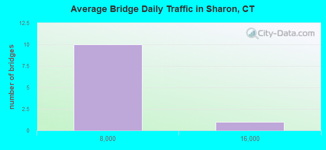
- 27,258Total average daily traffic
- 1,303Total average daily truck traffic
- 40,503Total future (year 2033) average daily traffic
- National Bridge Inventory (NBI) Registered Bridges for Sharon
- No street view available for this location
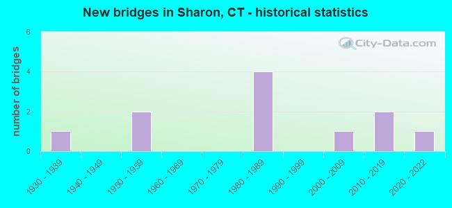
- New bridges - historical statistics
- 11930-1939
- 21950-1959
- 41980-1989
- 12000-2009
- 22010-2019
- 12020-2022
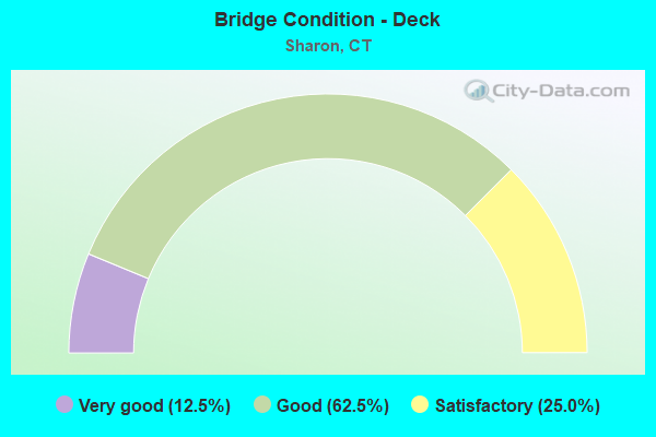
- Bridge Condition - Deck
- 12.5%Very good
- 62.5%Good
- 25.0%Satisfactory
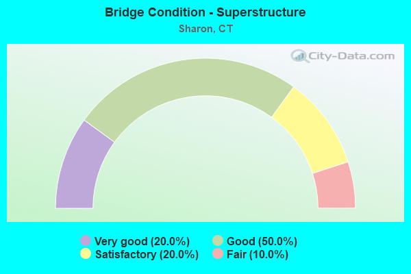
- Bridge Condition - Superstructure
- 20.0%Very good
- 50.0%Good
- 20.0%Satisfactory
- 10.0%Fair
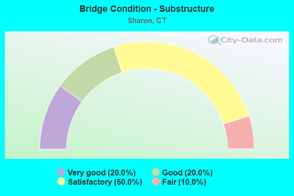
- Bridge Condition - Substructure
- 20.0%Very good
- 20.0%Good
- 50.0%Satisfactory
- 10.0%Fair
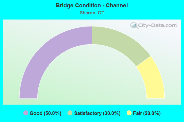
- Bridge Condition - Channel
- 50.0%Good
- 30.0%Satisfactory
- 20.0%Fair
Find on map >> Show street view
Structure Number: 42, Location: AT EXIT 10 (Lat: 41.068222, Lng: -73.490558), Route carried "on" structure: City street , Year Built: 1958, Status: Open, Structure Length: 5.09m (16.70ft), Average Daily Traffic: 14,200 (year 2017), Truck Traffic: 5%, Average Future Daily Traffic: 21,100 (year 2037), Design Load: HS 20, Features Intersected: INTERSTATE 95, Facility Carried by Structure: NOROTON AVENUE
Minimum Vertical Clearance: 30+ m (98+ ft), Kilometerpoint: 1.529, Lanes on structure: 4, Lanes under structure: 6, Owner: State Highway Agency, Approaching Roadway Width: 15.2m (49.9ft), Material/Design: Steel, Design/Construction: Stringer/Multi-beam, Number Of Spans In Main Unit: 2, Length of Maximum Span: 25.3m (83.0ft), Curb or Sidewalk Widths: Left: 1.5m (4.9ft), Right: 1.5m (4.9ft), Curb-To-Curb Width: 15.3m (50.2ft), Out-to-Out Width: 19.1m (62.7ft)
Condition: Deck: Satisfactory, Superstructure: Fair, Substructure: Satisfactory, Operating Rating: 87.4 metric tons, Method Used To Determine Operating Rating: Load Factor (LF), Inventory Rating: 52.4 metric tons, Method Used To Determine Inventory Rating: Load Factor (LF), Structural Evaluation: Somewhat better than minimum adequacy, Deck Geometry: High priority of corrective action, Underclear: High priority of corrective action, Approach Roadway Alignment: Equal to present desirable criteria, Designated Inspection Frequency: Every 24 months, Inspection Date: Febuary 2020, Deck Structure Type: Concrete Cast-file-Place, Wearing Surface/Protective System: Wearing Surface: Bituminous, Membrane: Preformed Fabric
Find on map >> Show street view
Structure Number: 42, Location: INTR SILVER LAKE SHORE RD (Lat: 41.890811, Lng: -73.480597), Route carried "on" structure: State highway 361, Year Built: 1957, Year Reconstructed: 1993, Status: Open, Structure Length: 1.29m (4.23ft), Average Daily Traffic: 1,400 (year 2018), Truck Traffic: 5%, Average Future Daily Traffic: 2,080 (year 2038), Design Load: HS 20, Features Intersected: MUDGE POND BROOK
Minimum Vertical Clearance: 30+ m (98+ ft), Kilometerpoint: 1.465, Lanes on structure: 2, Owner: State Highway Agency, Approaching Roadway Width: 10.7m (35.1ft), Skew: 1 degrees, Material/Design: Prestressed concrete, Design/Construction: Slab, Number Of Spans In Main Unit: 1, Length of Maximum Span: 11.8m (38.7ft), Curb-To-Curb Width: 10.8m (35.4ft), Out-to-Out Width: 11.9m (39.0ft)
Condition: Deck: Good, Superstructure: Good, Substructure: Satisfactory, Channel: Good, Operating Rating: 74.1 metric tons, Method Used To Determine Operating Rating: Load Factor (LF), Inventory Rating: 44.4 metric tons, Method Used To Determine Inventory Rating: Load Factor (LF), Structural Evaluation: Equal to present minimum criteria, Deck Geometry: Equal to present minimum criteria, Waterway Adequacy: Equal to present minimum criteria, Approach Roadway Alignment: Equal to present desirable criteria, Designated Inspection Frequency: Every 24 months, Inspection Date: April 2021, Deck Structure Type: Other, Wearing Surface/Protective System: Wearing Surface: Bituminous, Membrane: Built-up, Deck Protection: Epoxy Coated Reinforcing
Find on map >> Show street view
Structure Number: 422, Location: .5 MI WEST OF JCT RTE 7 (Lat: 41.821100, Lng: -73.382575), Route carried "on" structure: State highway 4, Year Built: 1934, Status: Open, Structure Length: 0.82m (2.69ft), Average Daily Traffic: 2,000 (year 2015), Truck Traffic: 4%, Average Future Daily Traffic: 2,972 (year 2035), Features Intersected: GUINEA BROOK
Minimum Vertical Clearance: 30+ m (98+ ft), Kilometerpoint: 11.684, Lanes on structure: 2, Base Highway Network: Yes, Owner: State Highway Agency, Approaching Roadway Width: 9.1m (29.9ft), Skew: 4 degrees, Material/Design: Concrete, Design/Construction: Arch - Deck, Number Of Spans In Main Unit: 1, Length of Maximum Span: 8.2m (26.9ft), Curb-To-Curb Width: 9.1m (29.9ft), Out-to-Out Width: 43.9m (144.0ft)
Condition: Superstructure: Satisfactory, Substructure: Satisfactory, Channel: Satisfactory, Structural Evaluation: Equal to present minimum criteria, Deck Geometry: Somewhat better than minimum adequacy, Waterway Adequacy: Superior to present desirable criteria, Approach Roadway Alignment: Equal to present desirable criteria, Designated Inspection Frequency: Every 24 months, Inspection Date: August 2020
Find on map >> Show street view
Structure Number: 4119, Location: 100'W OF BROOKSIDE DRIVE (Lat: 41.310344, Lng: -72.520694), Route carried "on" structure: City street , Year Built: 2021, Status: Open, Structure Length: 2.26m (7.41ft), Average Daily Traffic: 1,105 (year 2021), Truck Traffic: 4%, Average Future Daily Traffic: 1,642 (year 2041), Design Load: HL 93, Features Intersected: MENUNKETESUCK RIVER, Facility Carried by Structure: KELSEYTOWN ROAD
Minimum Vertical Clearance: 30+ m (98+ ft), Kilometerpoint: 0.097, Lanes on structure: 2, Owner: Town or Township Highway Agency, Approaching Roadway Width: 7.9m (25.9ft), Skew: 4 degrees, Material/Design: Prestressed concrete, Design/Construction: Box Beam or Girders - Single/Spread, Number Of Spans In Main Unit: 1, Length of Maximum Span: 20.4m (66.9ft), Curb or Sidewalk Widths: Left: 0.1m (0.3ft), Right: 0.1m (0.3ft), Curb-To-Curb Width: 7.9m (25.9ft), Out-to-Out Width: 9.1m (29.9ft)
Condition: Deck: Very good, Superstructure: Very good, Substructure: Very good, Channel: Good, Operating Rating: 83.3 metric tons, Method Used To Determine Operating Rating: Load and Resistance Factor Rating (LRFR) rating reported by rating factor(RF) method using HL-93 loadings, Inventory Rating: 62.9 metric tons, Method Used To Determine Inventory Rating: Load and Resistance Factor Rating (LRFR) rating reported by rating factor(RF) method using HL-93 loadings, Structural Evaluation: Equal to present desirable criteria, Deck Geometry: Meets minimum limits, Waterway Adequacy: Superior to present desirable criteria, Approach Roadway Alignment: Equal to present desirable criteria, Designated Inspection Frequency: Every 24 months, Inspection Date: September 2020, Total Project Cost: $2,835,000 ( Estimate for 2017), Deck Structure Type: Concrete Cast-file-Place, Wearing Surface/Protective System: Wearing Surface: Bituminous, Membrane: Other, Deck Protection: Galvanized Reinforcing
Find on map >> Show street view
Structure Number: 4121, Location: 1000 (N) INT RTE 94 (Lat: 41.718800, Lng: -72.576908), Route carried "on" structure: City street , Year Built: 2013, Status: Open, Structure Length: 0.98m (3.22ft), Average Daily Traffic: 3,570 (year 2021), Truck Traffic: 3%, Average Future Daily Traffic: 5,305 (year 2041), Design Load: HL 93, Features Intersected: SALMON BROOK, Facility Carried by Structure: ADDISON ROAD
Minimum Vertical Clearance: 30+ m (98+ ft), Kilometerpoint: 0.000, Lanes on structure: 2, Owner: Town or Township Highway Agency, Approaching Roadway Width: 7.3m (24.0ft), Skew: 1 degrees, Material/Design: Concrete, Design/Construction: Frame, Number Of Spans In Main Unit: 1, Length of Maximum Span: 9.8m (32.2ft), Curb or Sidewalk Widths: Left: 0.0m, Right: 1.3m (4.3ft), Curb-To-Curb Width: 7.3m (24.0ft), Out-to-Out Width: 10.1m (33.1ft)
Condition: Superstructure: Very good, Substructure: Very good, Channel: Good, Operating Rating: 51.5 metric tons, Method Used To Determine Operating Rating: Load and Resistance Factor Rating (LRFR) rating reported by rating factor(RF) method using HL-93 loadings, Inventory Rating: 39.5 metric tons, Method Used To Determine Inventory Rating: Load and Resistance Factor Rating (LRFR) rating reported by rating factor(RF) method using HL-93 loadings, Structural Evaluation: Equal to present desirable criteria, Deck Geometry: High priority of replacement, Waterway Adequacy: Equal to present desirable criteria, Approach Roadway Alignment: Equal to present desirable criteria, Designated Inspection Frequency: Every 24 months, Inspection Date: April 2021, Wearing Surface/Protective System: Wearing Surface: Bituminous, Membrane: Preformed Fabric, Deck Protection: Epoxy Coated Reinforcing
Find on map >> Show street view
Structure Number: 5191, Location: .7 MI W. OF ROUTE 361 (Lat: 41.884714, Lng: -73.493806), Route carried "on" structure: City street , Year Built: 2000, Status: Open, Structure Length: 1.28m (4.20ft), Average Daily Traffic: 673 (year 2017), Truck Traffic: 6%, Average Future Daily Traffic: 1,000 (year 2037), Design Load: HS 20, Features Intersected: WEBATUCK CREEK, Facility Carried by Structure: SHARON STATION RD
Minimum Vertical Clearance: 30+ m (98+ ft), Kilometerpoint: 0.354, Lanes on structure: 2, Owner: Town or Township Highway Agency, Approaching Roadway Width: 7.9m (25.9ft), Skew: 3 degrees, Material/Design: Prestressed concrete, Design/Construction: Slab, Number Of Spans In Main Unit: 1, Length of Maximum Span: 11.3m (37.1ft), Curb or Sidewalk Widths: Left: 0.2m (0.7ft), Right: 0.2m (0.7ft), Curb-To-Curb Width: 8.1m (26.6ft), Out-to-Out Width: 9.3m (30.5ft)
Condition: Deck: Good, Superstructure: Good, Substructure: Good, Channel: Satisfactory, Operating Rating: 57.1 metric tons, Method Used To Determine Operating Rating: Load Factor (LF), Inventory Rating: 34.2 metric tons, Method Used To Determine Inventory Rating: Load Factor (LF), Structural Evaluation: Better than present minimum criteria, Deck Geometry: Somewhat better than minimum adequacy, Waterway Adequacy: Equal to present minimum criteria, Approach Roadway Alignment: Equal to present desirable criteria, Designated Inspection Frequency: Every 24 months, Inspection Date: April 2021, Deck Structure Type: Other, Wearing Surface/Protective System: Wearing Surface: Bituminous, Membrane: Built-up, Deck Protection: Epoxy Coated Reinforcing
Find on map >> Show street view
Structure Number: 5324, Location: .4 MI N. OF ROUTE 343 (Lat: 41.877267, Lng: -73.496406), Route carried "on" structure: City street , Year Built: 1984, Status: Open, Structure Length: 0.76m (2.49ft), Average Daily Traffic: 626 (year 2017), Truck Traffic: 7%, Average Future Daily Traffic: 930 (year 2037), Features Intersected: INDIAN POND CREEK, Facility Carried by Structure: SHARON VALLEY RD
Minimum Vertical Clearance: 30+ m (98+ ft), Kilometerpoint: 0.612, Lanes on structure: 2, Owner: Town or Township Highway Agency, Approaching Roadway Width: 6.7m (22.0ft), Material/Design: Prestressed concrete, Design/Construction: Slab, Number Of Spans In Main Unit: 1, Length of Maximum Span: 6.1m (20.0ft), Curb-To-Curb Width: 7.1m (23.3ft), Out-to-Out Width: 7.3m (24.0ft)
Condition: Deck: Good, Superstructure: Good, Substructure: Fair, Channel: Fair, Operating Rating: 42.6 metric tons, Method Used To Determine Operating Rating: Field evaluation and documented engineering judgment, Inventory Rating: 32.7 metric tons, Method Used To Determine Inventory Rating: Field evaluation and documented engineering judgment, Structural Evaluation: Somewhat better than minimum adequacy, Deck Geometry: Meets minimum limits, Waterway Adequacy: Somewhat better than minimum adequacy, Approach Roadway Alignment: Equal to present desirable criteria, Designated Inspection Frequency: Every 24 months, Other Special Inspection Frequency: Every 12 months, Inspection Date: April 2021, Other Special Inspection Date: April 2021, Deck Structure Type: Other, Wearing Surface/Protective System: Wearing Surface: Bituminous, Membrane: Preformed Fabric
Find on map >> Show street view
Structure Number: 5362, Location: 0.4 MI S. OF ROUTE 4 (Lat: 41.814831, Lng: -73.377192), Route carried "on" structure: City street , Year Built: 1986, Status: Posted for load, Structure Length: 0.88m (2.89ft), Average Daily Traffic: 400 (year 2013), Truck Traffic: 7%, Average Future Daily Traffic: 594 (year 2033), Design Load: HS 20, Features Intersected: GUINEA BROOK, Facility Carried by Structure: RIVER ROAD
Minimum Vertical Clearance: 30+ m (98+ ft), Kilometerpoint: 0.966, Lanes on structure: 2, Owner: Town or Township Highway Agency, Approaching Roadway Width: 5.2m (17.1ft), Material/Design: Wood or Timber, Design/Construction: Slab, Number Of Spans In Main Unit: 1, Length of Maximum Span: 8.2m (26.9ft), Curb-To-Curb Width: 7.0m (23.0ft), Out-to-Out Width: 7.3m (24.0ft)
Condition: Deck: Satisfactory, Superstructure: Satisfactory, Substructure: Satisfactory, Channel: Fair, Operating Rating: 42.4 metric tons, Method Used To Determine Operating Rating: Allowable Stress (AS), Inventory Rating: 29.7 metric tons, Method Used To Determine Inventory Rating: Allowable Stress (AS), Structural Evaluation: Equal to present minimum criteria, Deck Geometry: Meets minimum limits, Waterway Adequacy: High priority of corrective action, Approach Roadway Alignment: Equal to present desirable criteria, Bridge Posting: Required (Relationship of Operating Rating to Maximum Legal Load: 0.1 - 9.9% below), Designated Inspection Frequency: Every 24 months, Inspection Date: April 2021, Deck Structure Type: Wood or Timber, Wearing Surface/Protective System: Wearing Surface: Bituminous, Deck Protection: Other
Find on map >> Show street view
Structure Number: 5388, Location: 600 FT E. SHARON VALLY RD (Lat: 41.883639, Lng: -73.491194), Route carried "on" structure: City street , Year Built: 1986, Status: Open, Structure Length: 0.79m (2.59ft), Average Daily Traffic: 1,784 (year 2017), Truck Traffic: 7%, Average Future Daily Traffic: 2,651 (year 2037), Features Intersected: INDIAN POND CREEK, Facility Carried by Structure: KING HILL ROAD
Minimum Vertical Clearance: 30+ m (98+ ft), Kilometerpoint: 0.209, Lanes on structure: 2, Owner: Town or Township Highway Agency, Approaching Roadway Width: 6.1m (20.0ft), Material/Design: Prestressed concrete, Design/Construction: Slab, Number Of Spans In Main Unit: 1, Length of Maximum Span: 6.7m (22.0ft), Curb-To-Curb Width: 7.2m (23.6ft), Out-to-Out Width: 7.3m (24.0ft)
Condition: Deck: Good, Superstructure: Good, Substructure: Satisfactory, Channel: Satisfactory, Operating Rating: 42.6 metric tons, Method Used To Determine Operating Rating: Field evaluation and documented engineering judgment, Inventory Rating: 32.7 metric tons, Method Used To Determine Inventory Rating: Field evaluation and documented engineering judgment, Structural Evaluation: Equal to present minimum criteria, Deck Geometry: High priority of corrective action, Waterway Adequacy: Better than present minimum criteria, Approach Roadway Alignment: Equal to present desirable criteria, Designated Inspection Frequency: Every 24 months, Inspection Date: April 2021, Deck Structure Type: Other, Wearing Surface/Protective System: Wearing Surface: Bituminous, Membrane: Preformed Fabric
Find on map >> Show street view
Structure Number: 5759, Location: 2 MI N OF INT OF 7 & RT 4 (Lat: 41.855272, Lng: -73.376033), Route carried "on" structure: US 7, Year Built: 1989, Status: Open, Structure Length: 1.43m (4.69ft), Average Daily Traffic: 1,400 (year 2018), Truck Traffic: 4%, Average Future Daily Traffic: 2,080 (year 2038), Design Load: HS 20, Features Intersected: CARSE BROOK
Minimum Vertical Clearance: 30+ m (98+ ft), Kilometerpoint: 101.002, Lanes on structure: 2, Base Highway Network: Yes, Owner: State Highway Agency, Approaching Roadway Width: 10.4m (34.1ft), Material/Design: Prestressed concrete, Design/Construction: Box Beam or Girders - Multiple, Number Of Spans In Main Unit: 1, Length of Maximum Span: 13.1m (43.0ft), Curb-To-Curb Width: 10.0m (32.8ft), Out-to-Out Width: 11.1m (36.4ft)
Condition: Deck: Good, Superstructure: Good, Substructure: Good, Channel: Good, Operating Rating: 93.4 metric tons, Method Used To Determine Operating Rating: Load Factor (LF), Inventory Rating: 55.3 metric tons, Method Used To Determine Inventory Rating: Load Factor (LF), Structural Evaluation: Better than present minimum criteria, Deck Geometry: Somewhat better than minimum adequacy, Waterway Adequacy: Equal to present desirable criteria, Approach Roadway Alignment: Equal to present desirable criteria, Designated Inspection Frequency: Every 48 months, Inspection Date: August 2019, Deck Structure Type: Other, Wearing Surface/Protective System: Wearing Surface: Bituminous, Membrane: Built-up, Deck Protection: Epoxy Coated Reinforcing
Find on map >> Show street view
Structure Number: 6927, Location: 0.2 M E OF S ELLSWORTH RD (Lat: 41.824361, Lng: -73.430056), Route carried "on" structure: City street , Year Built: 2016, Status: Open, Structure Length: 0.64m (2.10ft), Average Daily Traffic: 100 (year 2017), Truck Traffic: 1%, Average Future Daily Traffic: 149 (year 2037), Features Intersected: GUINEA BROOK, Facility Carried by Structure: WEST WOODS RD NO.2
Minimum Vertical Clearance: 30+ m (98+ ft), Kilometerpoint: 0.322, Lanes on structure: 2, Owner: Town or Township Highway Agency, Approaching Roadway Width: 6.2m (20.3ft), Material/Design: Steel, Design/Construction: Culvert, Number Of Spans In Main Unit: 2, Length of Maximum Span: 2.7m (8.9ft)
Condition: Channel: Good, Culverts: Good, Operating Rating: 97.2 metric tons, Method Used To Determine Operating Rating: Load and Resistance Factor Rating (LRFR) rating reported by rating factor(RF) method using HL-93 loadings, Inventory Rating: 97.2 metric tons, Method Used To Determine Inventory Rating: Load and Resistance Factor Rating (LRFR) rating reported by rating factor(RF) method using HL-93 loadings, Structural Evaluation: Better than present minimum criteria, Waterway Adequacy: Better than present minimum criteria, Approach Roadway Alignment: Equal to present desirable criteria, Designated Inspection Frequency: Every 24 months, Inspection Date: April 2021, Wearing Surface/Protective System: Wearing Surface: Bituminous