Bridge Statistics for Sheffield, Ohio (OH)
Condition, Traffic, Stress, Structural Evaluation, Project Costs
- National Bridge Inventory (NBI) Statistics
- 14Number of bridges
- 315ft / 96.3mTotal length
- 346,683Total average daily traffic
- 66,583Total average daily truck traffic
- National Bridge Inventory (NBI) Registered Bridges for Sheffield
- No street view available for this location
- New bridges - historical statistics
- 11900-1909
- 11920-1929
- 51970-1979
- 11990-1999
- 22000-2009
- 42010-2019
- Reconstructed bridges - Historical Statistics
- 11980-1989
- 11990-1999

- Bridge Condition - Deck
- 20.0%Excellent
- 30.0%Very good
- 10.0%Good
- 10.0%Satisfactory
- 20.0%Fair
- 10.0%Poor
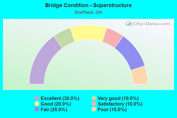
- Bridge Condition - Superstructure
- 30.0%Excellent
- 10.0%Very good
- 20.0%Good
- 10.0%Satisfactory
- 20.0%Fair
- 10.0%Poor
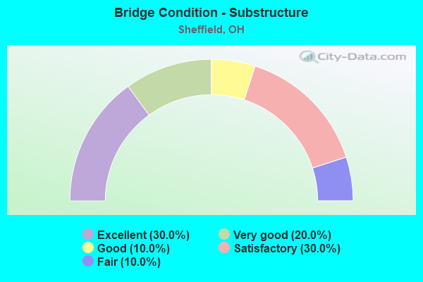
- Bridge Condition - Substructure
- 30.0%Excellent
- 20.0%Very good
- 10.0%Good
- 30.0%Satisfactory
- 10.0%Fair
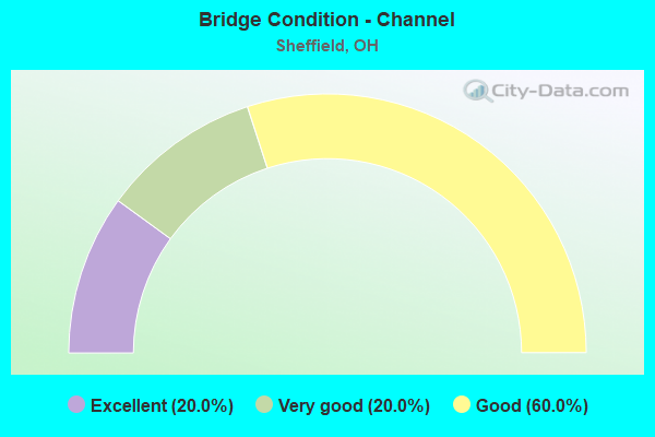
- Bridge Condition - Channel
- 20.0%Excellent
- 20.0%Very good
- 60.0%Good
Find on map >> Show street view
Structure Number: 47048, Location: .93 MILES EAST OF SR 254 (Lat: 41.437389, Lng: -82.080000), Route carried "on" structure: Interstate 90, Year Built: 1970, Status: Open, Structure Length: 0.85m (2.79ft), Average Daily Traffic: 54,944 (year 2015), Truck Traffic: 28%, Average Future Daily Traffic: 76,262 (year 2035), Design Load: HS 20+Mod, Features Intersected: JUNGBLUTH DITCH
Minimum Vertical Clearance: 30+ m (98+ ft), Kilometerpoint: 26.683, Lanes on structure: 4, Base Highway Network: Yes, Owner: State Highway Agency, Approaching Roadway Width: 24.4m (80.1ft), Skew: 4 degrees, Material/Design: Steel, Design/Construction: Culvert, Number Of Spans In Main Unit: 1, Length of Maximum Span: 6.2m (20.3ft)
Condition: Channel: Good, Culverts: Satisfactory, Operating Rating: 42.1 metric tons, Method Used To Determine Operating Rating: Load Factor (LF) rating reported by rating factor (RF) method using MS18 loading, Inventory Rating: 32.4 metric tons, Method Used To Determine Inventory Rating: Load Factor (LF) rating reported by rating factor (RF) method using MS18 loading, Structural Evaluation: Equal to present minimum criteria, Waterway Adequacy: Equal to present desirable criteria, Approach Roadway Alignment: Equal to present desirable criteria, Designated Inspection Frequency: Every 12 months, Inspection Date: December 2021
Find on map >> Show street view
Structure Number: 4704835, Location: .53 MILES EAST OF SR 301 (Lat: 41.449469, Lng: -82.070869), Route carried "on" structure: City street M0022, Year Built: 2015, Status: Open, Structure Length: 9.60m (31.50ft), Average Daily Traffic: 1,960 (year 2015), Truck Traffic: 4%, Average Future Daily Traffic: 75,493 (year 2035), Design Load: HS 20+Mod, Features Intersected: OVER LOR-090 -1753, Facility Carried by Structure: T-22# FRENCH CREEK
Minimum Vertical Clearance: 30+ m (98+ ft), Kilometerpoint: 26.232, Lanes on structure: 2, Lanes under structure: 4, Owner: State Highway Agency, Approaching Roadway Width: 7.3m (24.0ft), Skew: 2 degrees, Material/Design: Steel continuous, Design/Construction: Stringer/Multi-beam, Number Of Spans In Main Unit: 4, Length of Maximum Span: 28.7m (94.2ft), Curb or Sidewalk Widths: Left: 1.5m (4.9ft), Right: 1.5m (4.9ft), Curb-To-Curb Width: 7.3m (24.0ft), Out-to-Out Width: 11.0m (36.1ft)
Condition: Deck: Excellent, Superstructure: Excellent, Substructure: Excellent, Operating Rating: 55.1 metric tons, Method Used To Determine Operating Rating: Load and Resistance Factor Rating (LRFR) rating reported by rating factor(RF) method using HL-93 loadings, Inventory Rating: 42.1 metric tons, Method Used To Determine Inventory Rating: Load and Resistance Factor Rating (LRFR) rating reported by rating factor(RF) method using HL-93 loadings, Structural Evaluation: Superior to present desirable criteria, Deck Geometry: Meets minimum limits, Underclear: High priority of corrective action, Approach Roadway Alignment: Equal to present desirable criteria, Designated Inspection Frequency: Every 24 months, Inspection Date: December 2021, Deck Structure Type: Concrete Cast-file-Place, Wearing Surface/Protective System: Wearing Surface: Monolithic Concrete, Membrane: Other, Deck Protection: Epoxy Coated Reinforcing
Find on map >> Show street view
Structure Number: 4704894, Location: .85 MILES EAST OF SR 301 (Lat: 41.453619, Lng: -82.067531), Route carried "on" structure: Interstate 90, Year Built: 1970, Status: Open, Structure Length: 4.69m (15.39ft), Average Daily Traffic: 27,472 (year 2015), Truck Traffic: 28%, Average Future Daily Traffic: 38,131 (year 2035), Design Load: HS 20+Mod, Features Intersected: OVER N/S RR
Minimum Vertical Clearance: 30+ m (98+ ft), Kilometerpoint: 28.727, Lanes on structure: 2, Base Highway Network: Yes, Owner: State Highway Agency, Approaching Roadway Width: 15.2m (49.9ft), Skew: 2 degrees, Material/Design: Steel continuous, Design/Construction: Stringer/Multi-beam, Number Of Spans In Main Unit: 3, Length of Maximum Span: 17.7m (58.1ft), Curb or Sidewalk Widths: Left: 0.3m (1.0ft), Right: 0.3m (1.0ft), Curb-To-Curb Width: 11.7m (38.4ft), Out-to-Out Width: 12.8m (42.0ft)
Condition: Deck: Fair, Superstructure: Fair, Substructure: Satisfactory, Operating Rating: 58.3 metric tons, Method Used To Determine Operating Rating: Load Factor (LF) rating reported by rating factor (RF) method using MS18 loading, Inventory Rating: 35.6 metric tons, Method Used To Determine Inventory Rating: Load Factor (LF) rating reported by rating factor (RF) method using MS18 loading, Structural Evaluation: Somewhat better than minimum adequacy, Deck Geometry: Equal to present minimum criteria, Underclear: Superior to present desirable criteria, Approach Roadway Alignment: Equal to present desirable criteria, Designated Inspection Frequency: Every 12 months, Inspection Date: June 2021, Deck Structure Type: Concrete Cast-file-Place, Wearing Surface/Protective System: Wearing Surface: Bituminous
Find on map >> Show street view
Structure Number: 4704924, Location: .85 MILES EAST OF SR 301 (Lat: 41.453300, Lng: -82.067361), Route carried "on" structure: Interstate 90, Year Built: 1970, Status: Open, Structure Length: 4.97m (16.31ft), Average Daily Traffic: 27,472 (year 2015), Truck Traffic: 28%, Average Future Daily Traffic: 38,131 (year 2035), Design Load: HS 20, Features Intersected: OVER N/S RR
Minimum Vertical Clearance: 30+ m (98+ ft), Kilometerpoint: 28.727, Lanes on structure: 2, Base Highway Network: Yes, Owner: State Highway Agency, Approaching Roadway Width: 15.2m (49.9ft), Skew: 3 degrees, Material/Design: Steel continuous, Design/Construction: Stringer/Multi-beam, Number Of Spans In Main Unit: 3, Length of Maximum Span: 18.3m (60.0ft), Curb-To-Curb Width: 11.6m (38.1ft), Out-to-Out Width: 12.8m (42.0ft)
Condition: Deck: Fair, Superstructure: Fair, Substructure: Satisfactory, Operating Rating: 42.1 metric tons, Method Used To Determine Operating Rating: Load Factor (LF) rating reported by rating factor (RF) method using MS18 loading, Inventory Rating: 32.4 metric tons, Method Used To Determine Inventory Rating: Load Factor (LF) rating reported by rating factor (RF) method using MS18 loading, Structural Evaluation: Somewhat better than minimum adequacy, Deck Geometry: Equal to present minimum criteria, Underclear: Superior to present desirable criteria, Approach Roadway Alignment: Equal to present desirable criteria, Designated Inspection Frequency: Every 12 months, Inspection Date: June 2021, Deck Structure Type: Concrete Cast-file-Place, Wearing Surface/Protective System: Wearing Surface: Bituminous
Find on map >> Show street view
Structure Number: 470625, Location: 0.9 MI. E. OF JCT SR 57 (Lat: 41.420481, Lng: -82.101989), Route carried "on" structure: State highway 254, Year Built: 2001, Status: Open, Structure Length: 43.31m (142.09ft), Average Daily Traffic: 16,338 (year 2015), Truck Traffic: 2%, Average Future Daily Traffic: 22,677 (year 2035), Design Load: HS 20+Mod, Features Intersected: BLACK RIVER AND METROPRK, Facility Carried by Structure: NORTH RIDGE ROAD
Minimum Vertical Clearance: 30+ m (98+ ft), Kilometerpoint: 1.448, Lanes on structure: 4, Owner: State Highway Agency, Approaching Roadway Width: 16.8m (55.1ft), Material/Design: Prestressed concrete continuous, Design/Construction: Stringer/Multi-beam, Number Of Spans In Main Unit: 12, Length of Maximum Span: 36.3m (119.1ft), Curb or Sidewalk Widths: Left: 1.5m (4.9ft), Right: 1.5m (4.9ft), Curb-To-Curb Width: 15.6m (51.2ft), Out-to-Out Width: 19.2m (63.0ft)
Condition: Deck: Good, Superstructure: Good, Substructure: Very good, Channel: Very good, Operating Rating: 52.8 metric tons, Method Used To Determine Operating Rating: Load Factor (LF) rating reported by rating factor (RF) method using MS18 loading, Inventory Rating: 31.8 metric tons, Method Used To Determine Inventory Rating: Load Factor (LF) rating reported by rating factor (RF) method using MS18 loading, Structural Evaluation: Better than present minimum criteria, Deck Geometry: Meets minimum limits, Waterway Adequacy: Superior to present desirable criteria, Approach Roadway Alignment: Superior to present desirable criteria, Designated Inspection Frequency: Every 24 months, Inspection Date: September 2021, Deck Structure Type: Concrete Cast-file-Place, Wearing Surface/Protective System: Wearing Surface: Monolithic Concrete, Deck Protection: Epoxy Coated Reinforcing
Find on map >> Show street view
Structure Number: 4706277, Location: 1.91 MILES EAST OF SR 57 (Lat: 41.424250, Lng: -82.083511), Route carried "on" structure: State highway 254, Year Built: 1970, Year Reconstructed: 2003, Status: Open, Structure Length: 9.27m (30.41ft), Average Daily Traffic: 24,269 (year 2015), Truck Traffic: 3%, Average Future Daily Traffic: 33,685 (year 2035), Design Load: HS 20+Mod, Features Intersected: OVER LOR-090-1565
Minimum Vertical Clearance: 30+ m (98+ ft), Kilometerpoint: 3.074, Lanes on structure: 5, Lanes under structure: 4, Owner: State Highway Agency, Approaching Roadway Width: 26.8m (87.9ft), Skew: 2 degrees, Material/Design: Steel continuous, Design/Construction: Stringer/Multi-beam, Number Of Spans In Main Unit: 4, Length of Maximum Span: 26.8m (87.9ft), Curb-To-Curb Width: 26.8m (87.9ft), Out-to-Out Width: 27.7m (90.9ft)
Condition: Deck: Very good, Superstructure: Good, Substructure: Good, Operating Rating: 64.8 metric tons, Method Used To Determine Operating Rating: Load and Resistance Factor Rating (LRFR) rating reported by rating factor(RF) method using HL-93 loadings, Inventory Rating: 48.6 metric tons, Method Used To Determine Inventory Rating: Load and Resistance Factor Rating (LRFR) rating reported by rating factor(RF) method using HL-93 loadings, Structural Evaluation: Better than present minimum criteria, Deck Geometry: Superior to present desirable criteria, Underclear: High priority of corrective action, Approach Roadway Alignment: Better than present minimum criteria, Designated Inspection Frequency: Every 24 months, Inspection Date: December 2021, Deck Structure Type: Concrete Cast-file-Place, Wearing Surface/Protective System: Wearing Surface: Monolithic Concrete, Deck Protection: Epoxy Coated Reinforcing
Find on map >> Show street view
Structure Number: 470673, Location: 1.14 MILES N OF SR 254 (Lat: 41.442589, Lng: -82.075631), Route carried "on" structure: State highway 301, Year Built: 2013, Status: Open, Structure Length: 11.74m (38.52ft), Average Daily Traffic: 9,549 (year 2015), Truck Traffic: 6%, Average Future Daily Traffic: 13,254 (year 2035), Design Load: HL 93, Features Intersected: OVER IR LOR-90-1700
Minimum Vertical Clearance: 30+ m (98+ ft), Kilometerpoint: 37.803, Lanes on structure: 2, Lanes under structure: 4, Owner: State Highway Agency, Approaching Roadway Width: 9.1m (29.9ft), Skew: 4 degrees, Material/Design: Prestressed concrete continuous, Design/Construction: Stringer/Multi-beam, Number Of Spans In Main Unit: 4, Length of Maximum Span: 33.5m (109.9ft), Curb or Sidewalk Widths: Left: 1.5m (4.9ft), Right: 1.5m (4.9ft), Curb-To-Curb Width: 9.1m (29.9ft), Out-to-Out Width: 12.8m (42.0ft)
Condition: Deck: Excellent, Superstructure: Excellent, Substructure: Excellent, Operating Rating: 51.8 metric tons, Method Used To Determine Operating Rating: Load and Resistance Factor Rating (LRFR) rating reported by rating factor(RF) method using HL-93 loadings, Inventory Rating: 38.9 metric tons, Method Used To Determine Inventory Rating: Load and Resistance Factor Rating (LRFR) rating reported by rating factor(RF) method using HL-93 loadings, Structural Evaluation: Superior to present desirable criteria, Deck Geometry: Meets minimum limits, Underclear: High priority of corrective action, Approach Roadway Alignment: Equal to present desirable criteria, Designated Inspection Frequency: Every 24 months, Inspection Date: December 2021, Deck Structure Type: Concrete Cast-file-Place, Wearing Surface/Protective System: Wearing Surface: Monolithic Concrete, Deck Protection: Epoxy Coated Reinforcing
Find on map >> Show street view
Structure Number: 4706803, Location: 1.5 MILES NORTH OF IR-90 (Lat: 41.463989, Lng: -82.076211), Route carried "on" structure: State highway 301, Year Built: 2008, Status: Open, Structure Length: 2.29m (7.51ft), Average Daily Traffic: 9,549 (year 2015), Truck Traffic: 6%, Average Future Daily Traffic: 13,254 (year 2035), Design Load: HS 20+Mod, Features Intersected: OVER FRENCH CREEK
Minimum Vertical Clearance: 30+ m (98+ ft), Kilometerpoint: 40.218, Lanes on structure: 2, Owner: State Highway Agency, Approaching Roadway Width: 12.6m (41.3ft), Skew: 3 degrees, Material/Design: Steel, Design/Construction: Stringer/Multi-beam, Number Of Spans In Main Unit: 1, Length of Maximum Span: 22.3m (73.2ft), Curb-To-Curb Width: 12.0m (39.4ft), Out-to-Out Width: 12.0m (39.4ft)
Condition: Deck: Very good, Superstructure: Excellent, Substructure: Excellent, Channel: Excellent, Operating Rating: 42.1 metric tons, Method Used To Determine Operating Rating: Load Factor (LF) rating reported by rating factor (RF) method using MS18 loading, Inventory Rating: 32.4 metric tons, Method Used To Determine Inventory Rating: Load Factor (LF) rating reported by rating factor (RF) method using MS18 loading, Structural Evaluation: Equal to present desirable criteria, Deck Geometry: Somewhat better than minimum adequacy, Waterway Adequacy: Equal to present desirable criteria, Approach Roadway Alignment: Equal to present desirable criteria, Designated Inspection Frequency: Every 24 months, Inspection Date: July 2021, Deck Structure Type: Concrete Cast-file-Place, Wearing Surface/Protective System: Wearing Surface: Monolithic Concrete, Deck Protection: Epoxy Coated Reinforcing
Find on map >> Show street view
Structure Number: 4706838, Location: .88 MILES NORTH OF SR 611 (Lat: 41.478400, Lng: -82.075569), Route carried "on" structure: State highway 301, Year Built: 1995, Status: Open, Structure Length: 7.25m (23.79ft), Average Daily Traffic: 9,293 (year 2015), Truck Traffic: 6%, Average Future Daily Traffic: 12,899 (year 2035), Design Load: HS 20+Mod, Features Intersected: OVER N&W RR AND ROAD
Minimum Vertical Clearance: 30+ m (98+ ft), Kilometerpoint: 41.827, Lanes on structure: 2, Owner: State Highway Agency, Approaching Roadway Width: 20.7m (67.9ft), Material/Design: Steel continuous, Design/Construction: Stringer/Multi-beam, Number Of Spans In Main Unit: 3, Length of Maximum Span: 30.2m (99.1ft), Curb-To-Curb Width: 20.7m (67.9ft), Out-to-Out Width: 21.6m (70.9ft)
Condition: Deck: Very good, Superstructure: Very good, Substructure: Very good, Operating Rating: 58.3 metric tons, Method Used To Determine Operating Rating: Load and Resistance Factor Rating (LRFR) rating reported by rating factor(RF) method using HL-93 loadings, Inventory Rating: 45.4 metric tons, Method Used To Determine Inventory Rating: Load and Resistance Factor Rating (LRFR) rating reported by rating factor(RF) method using HL-93 loadings, Structural Evaluation: Equal to present desirable criteria, Deck Geometry: Superior to present desirable criteria, Underclear: Equal to present desirable criteria, Approach Roadway Alignment: Equal to present desirable criteria, Designated Inspection Frequency: Every 24 months, Inspection Date: July 2021, Deck Structure Type: Concrete Cast-file-Place, Wearing Surface/Protective System: Wearing Surface: Monolithic Concrete, Deck Protection: Epoxy Coated Reinforcing
Find on map >> Show street view
Structure Number: 4734, Location: 0.2 miles south of 611 (Lat: 41.458119, Lng: -82.105631), Route carried "on" structure: County highway C0017, Year Built: 1900, Status: Open, Structure Length: 1.65m (5.41ft), Average Daily Traffic: 9,500 (year 2017), Truck Traffic: 6%, Average Future Daily Traffic: 9,547 (year 2037), Design Load: HS 15, Features Intersected: French Ck, Facility Carried by Structure: East River Rd.
Minimum Vertical Clearance: 30+ m (98+ ft), Kilometerpoint: 10.429, Lanes on structure: 2, Owner: County Highway Agency, Approaching Roadway Width: 7.8m (25.6ft), Material/Design: Concrete, Design/Construction: Tee Beam, Number Of Spans In Main Unit: 1, Length of Maximum Span: 15.2m (49.9ft), Curb or Sidewalk Widths: Left: 0.0m, Right: 1.2m (3.9ft), Curb-To-Curb Width: 7.3m (24.0ft), Out-to-Out Width: 8.1m (26.6ft)
Condition: Deck: Satisfactory, Superstructure: Satisfactory, Substructure: Satisfactory, Channel: Good, Operating Rating: 45.4 metric tons, Method Used To Determine Operating Rating: Load Factor (LF) rating reported by rating factor (RF) method using MS18 loading, Inventory Rating: 25.9 metric tons, Method Used To Determine Inventory Rating: Load Factor (LF) rating reported by rating factor (RF) method using MS18 loading, Structural Evaluation: Equal to present minimum criteria, Deck Geometry: High priority of replacement, Waterway Adequacy: Equal to present desirable criteria, Approach Roadway Alignment: Somewhat better than minimum adequacy, Designated Inspection Frequency: Every 12 months, Inspection Date: November 2021, Deck Structure Type: Concrete Cast-file-Place, Wearing Surface/Protective System: Wearing Surface: Bituminous
Find on map >> Show street view
Structure Number: 4739833, Location: .33MI.WEST OF ABBE (Lat: 41.449619, Lng: -82.082869), Route carried "on" structure: City street M0022, Year Built: 1929, Year Reconstructed: 1988, Status: Open, Structure Length: 0.73m (2.40ft), Average Daily Traffic: 8,129 (year 2015), Truck Traffic: 2%, Average Future Daily Traffic: 11,283 (year 2035), Design Load: HS 20+Mod, Features Intersected: JUNGBLUTH DT FRENCH, Facility Carried by Structure: FRENCH CREEK RD.
Minimum Vertical Clearance: 30+ m (98+ ft), Kilometerpoint: 1.658, Lanes on structure: 2, Owner: County Highway Agency, Approaching Roadway Width: 9.1m (29.9ft), Skew: 4 degrees, Material/Design: Prestressed concrete, Design/Construction: Box Beam or Girders - Multiple, Number Of Spans In Main Unit: 1, Length of Maximum Span: 6.1m (20.0ft), Curb-To-Curb Width: 9.6m (31.5ft), Out-to-Out Width: 9.8m (32.2ft)
Condition: Deck: Poor, Superstructure: Poor, Substructure: Fair, Channel: Good, Operating Rating: 42.1 metric tons, Method Used To Determine Operating Rating: Load Factor (LF) rating reported by rating factor (RF) method using MS18 loading, Inventory Rating: 32.4 metric tons, Method Used To Determine Inventory Rating: Load Factor (LF) rating reported by rating factor (RF) method using MS18 loading, Structural Evaluation: Meets minimum limits, Deck Geometry: High priority of corrective action, Waterway Adequacy: Equal to present desirable criteria, Approach Roadway Alignment: Equal to present desirable criteria, Designated Inspection Frequency: Every 12 months, Inspection Date: October 2021, Deck Structure Type: Concrete Cast-file-Place, Wearing Surface/Protective System: Wearing Surface: Bituminous
Find on map >> Show street view
Structure Number: 4704835, Location: .53 MILES EAST OF SR 301 (Lat: 41.449469, Lng: -82.070869), Route carried "under" structure: Interstate 90, Year Built: 2015, Structure Length: 0. m, Average Daily Traffic: 54,390 (year 2015), Truck Traffic: 11%, Features Intersected: UNDER FRENCH CREEK TH-22, Facility Carried by Structure: T-22# FRENCH CREEK
Minimum Vertical Clearance: 5.03m (16.50ft), Kilometerpoint: 28.212, Lanes on structure: 2, Lanes under structure: 4, Material/Design: Steel continuous, Design/Construction: Stringer/Multi-beam, Length of Maximum Span: 28.7m (94.2ft)
Find on map >> Show street view
Structure Number: 4706277, Location: 1.91 MILES EAST OF SR 57 (Lat: 41.424250, Lng: -82.083511), Route carried "under" structure: Interstate 90, Year Built: 1970, Structure Length: 0. m, Average Daily Traffic: 38,874 (year 2015), Truck Traffic: 28%, Features Intersected: UNDER LOR 254-0191, Facility Carried by Structure: SR 254
Minimum Vertical Clearance: 4.65m (15.26ft), Kilometerpoint: 25.186, Lanes on structure: 5, Lanes under structure: 4, Material/Design: Steel continuous, Design/Construction: Stringer/Multi-beam, Length of Maximum Span: 26.8m (87.9ft)
Find on map >> Show street view
Structure Number: 470673, Location: 1.14 MILES N OF SR 254 (Lat: 41.442589, Lng: -82.075631), Route carried "under" structure: Interstate 90, Year Built: 2013, Structure Length: 0. m, Average Daily Traffic: 54,944 (year 2015), Truck Traffic: 28%, Features Intersected: UNDER LOR-301-23.49, Facility Carried by Structure: SR 301
Minimum Vertical Clearance: 5.57m (18.27ft), Kilometerpoint: 27.359, Lanes on structure: 2, Lanes under structure: 4, Material/Design: Prestressed concrete continuous, Design/Construction: Stringer/Multi-beam, Length of Maximum Span: 33.5m (109.9ft)