Bridge Statistics for Shorter, Alabama (AL)
Condition, Traffic, Stress, Structural Evaluation, Project Costs
- National Bridge Inventory (NBI) Statistics
- 25Number of bridges
- 623ft / 190mTotal length
- $55,875,000Total costs
- 375,943Total average daily traffic
- 79,387Total average daily truck traffic
- National Bridge Inventory (NBI) Registered Bridges for Shorter
- No street view available for this location
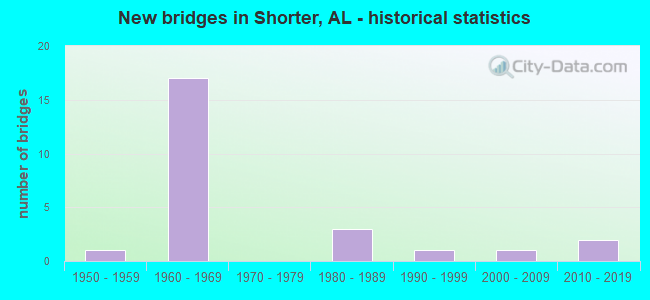
- New bridges - historical statistics
- 11950-1959
- 171960-1969
- 31980-1989
- 11990-1999
- 12000-2009
- 22010-2019
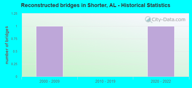
- Reconstructed bridges - Historical Statistics
- 12000-2009
- 02010-2019
- 12020-2022
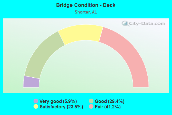
- Bridge Condition - Deck
- 5.9%Very good
- 29.4%Good
- 23.5%Satisfactory
- 41.2%Fair
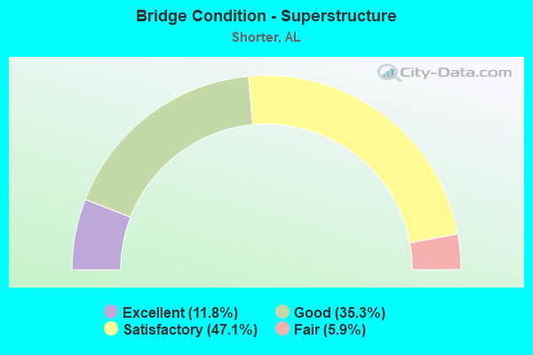
- Bridge Condition - Superstructure
- 11.8%Excellent
- 35.3%Good
- 47.1%Satisfactory
- 5.9%Fair
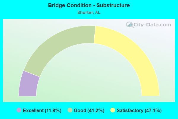
- Bridge Condition - Substructure
- 11.8%Excellent
- 41.2%Good
- 47.1%Satisfactory
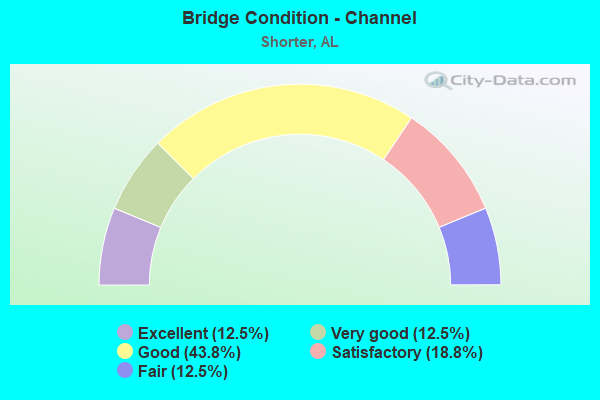
- Bridge Condition - Channel
- 12.5%Excellent
- 12.5%Very good
- 43.8%Good
- 18.8%Satisfactory
- 12.5%Fair
Find on map >> Show street view
Structure Number: 7264, Location: 1.2 MI.N.OF MONTG.CO.LINE (Lat: 32.386567, Lng: -85.994539), Route carried "on" structure: County highway , Year Built: 1961, Status: Open, Structure Length: 8.08m (26.51ft), Average Daily Traffic: 853 (year 2003), Truck Traffic: 2%, Average Future Daily Traffic: 1,279 (year 2028), Design Load: HS 20, Features Intersected: I85, Facility Carried by Structure: CO RD 0097
Minimum Vertical Clearance: 30+ m (98+ ft), Kilometerpoint: 0.628, Lanes on structure: 2, Lanes under structure: 4, Owner: State Highway Agency, Approaching Roadway Width: 9.1m (29.9ft), Skew: 1 degrees, Material/Design: Concrete continuous, Design/Construction: Tee Beam, Number Of Spans In Main Unit: 4, Length of Maximum Span: 22.3m (73.2ft), Curb-To-Curb Width: 7.3m (24.0ft), Out-to-Out Width: 8.8m (28.9ft)
Condition: Deck: Fair, Superstructure: Satisfactory, Substructure: Satisfactory, Operating Rating: 57.1 metric tons, Method Used To Determine Operating Rating: Load Factor (LF), Inventory Rating: 33.6 metric tons, Method Used To Determine Inventory Rating: Load Factor (LF), Structural Evaluation: Equal to present minimum criteria, Deck Geometry: Meets minimum limits, Underclear: Somewhat better than minimum adequacy, Approach Roadway Alignment: Better than present minimum criteria, Length Of Structure Improvement: 9.08m (29.79ft), Designated Inspection Frequency: Every 24 months, Inspection Date: May 2021, Bridge Improvement Cost: $1,744,000, Roadway Improvement Cost: $174,000, Total Project Cost: $1,918,000 ( Estimate for 2019), Deck Structure Type: Concrete Cast-file-Place
Find on map >> Show street view
Structure Number: 7265, Location: 2.2 MI.N.OF MONTG.CO.LINE (Lat: 32.395225, Lng: -85.980331), Route carried "on" structure: Interstate 85, Year Built: 1961, Status: Open, Structure Length: 13.47m (44.19ft), Average Daily Traffic: 18,020 (year 2013), Truck Traffic: 21%, Average Future Daily Traffic: 23,749 (year 2033), Design Load: HS 20, Features Intersected: CUBAHATCHEE CRK.RELIEF
Minimum Vertical Clearance: 30+ m (98+ ft), Kilometerpoint: 33.310, Lanes on structure: 2, Base Highway Network: Yes, Owner: State Highway Agency, Approaching Roadway Width: 12.2m (40.0ft), Skew: 10 degrees, Material/Design: Concrete, Design/Construction: Tee Beam, Number Of Spans In Main Unit: 13, Length of Maximum Span: 10.4m (34.1ft), Curb-To-Curb Width: 8.5m (27.9ft), Out-to-Out Width: 10.1m (33.1ft)
Condition: Deck: Fair, Superstructure: Satisfactory, Substructure: Satisfactory, Channel: Good, Operating Rating: 48.3 metric tons, Method Used To Determine Operating Rating: Load Factor (LF), Inventory Rating: 28.9 metric tons, Method Used To Determine Inventory Rating: Load Factor (LF), Structural Evaluation: Equal to present minimum criteria, Deck Geometry: High priority of corrective action, Waterway Adequacy: Equal to present desirable criteria, Approach Roadway Alignment: Better than present minimum criteria, Length Of Structure Improvement: 14.28m (46.85ft), Designated Inspection Frequency: Every 24 months, Inspection Date: June 2021, Bridge Improvement Cost: $3,231,000, Roadway Improvement Cost: $323,000, Total Project Cost: $3,554,000 ( Estimate for 2022), Deck Structure Type: Concrete Cast-file-Place
Find on map >> Show street view
Structure Number: 7266, Location: 2.2 MI.N.OF MONTG.CO.LINE (Lat: 32.395039, Lng: -85.980169), Route carried "on" structure: Interstate 85, Year Built: 1961, Status: Open, Structure Length: 13.47m (44.19ft), Average Daily Traffic: 18,020 (year 2013), Truck Traffic: 21%, Average Future Daily Traffic: 23,749 (year 2033), Design Load: HS 20, Features Intersected: CUBAHATCHEE CRK.RELIEF
Minimum Vertical Clearance: 30+ m (98+ ft), Kilometerpoint: 33.310, Lanes on structure: 2, Base Highway Network: Yes, Owner: State Highway Agency, Approaching Roadway Width: 12.2m (40.0ft), Skew: 10 degrees, Material/Design: Concrete, Design/Construction: Tee Beam, Number Of Spans In Main Unit: 13, Length of Maximum Span: 10.4m (34.1ft), Curb-To-Curb Width: 8.5m (27.9ft), Out-to-Out Width: 10.1m (33.1ft)
Condition: Deck: Fair, Superstructure: Satisfactory, Substructure: Satisfactory, Channel: Good, Operating Rating: 48.3 metric tons, Method Used To Determine Operating Rating: Load Factor (LF), Inventory Rating: 28.9 metric tons, Method Used To Determine Inventory Rating: Load Factor (LF), Structural Evaluation: Equal to present minimum criteria, Deck Geometry: High priority of corrective action, Waterway Adequacy: Equal to present desirable criteria, Approach Roadway Alignment: Better than present minimum criteria, Length Of Structure Improvement: 14.28m (46.85ft), Designated Inspection Frequency: Every 24 months, Inspection Date: June 2021, Bridge Improvement Cost: $3,231,000, Roadway Improvement Cost: $323,000, Total Project Cost: $3,554,000 ( Estimate for 2022), Deck Structure Type: Concrete Cast-file-Place
Find on map >> Show street view
Structure Number: 7267, Location: 2.5 MI.N.OF MONTG.CO.LINE (Lat: 32.398206, Lng: -85.975203), Route carried "on" structure: Interstate 85, Year Built: 1961, Status: Open, Structure Length: 12.92m (42.39ft), Average Daily Traffic: 18,020 (year 2013), Truck Traffic: 21%, Average Future Daily Traffic: 23,749 (year 2033), Design Load: HS 20, Features Intersected: CUBAHATCHEE CREEK
Minimum Vertical Clearance: 30+ m (98+ ft), Kilometerpoint: 33.833, Lanes on structure: 2, Base Highway Network: Yes, Owner: State Highway Agency, Approaching Roadway Width: 12.2m (40.0ft), Skew: 10 degrees, Material/Design: Concrete, Design/Construction: Tee Beam, Number Of Spans In Main Unit: 12, Length of Maximum Span: 15.2m (49.9ft), Curb-To-Curb Width: 8.5m (27.9ft), Out-to-Out Width: 10.1m (33.1ft)
Condition: Deck: Fair, Superstructure: Satisfactory, Substructure: Satisfactory, Channel: Good, Operating Rating: 47.5 metric tons, Method Used To Determine Operating Rating: Load Factor (LF), Inventory Rating: 28.6 metric tons, Method Used To Determine Inventory Rating: Load Factor (LF), Structural Evaluation: Equal to present minimum criteria, Deck Geometry: High priority of corrective action, Waterway Adequacy: Superior to present desirable criteria, Approach Roadway Alignment: Better than present minimum criteria, Length Of Structure Improvement: 13.75m (45.11ft), Designated Inspection Frequency: Every 24 months, Inspection Date: July 2021, Bridge Improvement Cost: $3,110,000, Roadway Improvement Cost: $311,000, Total Project Cost: $3,421,000 ( Estimate for 2022), Deck Structure Type: Concrete Cast-file-Place
Find on map >> Show street view
Structure Number: 7268, Location: 2.5 MI.N.OF MONTG.CO.LINE (Lat: 32.398050, Lng: -85.974944), Route carried "on" structure: Interstate 85, Year Built: 1961, Status: Open, Structure Length: 12.92m (42.39ft), Average Daily Traffic: 18,020 (year 2013), Truck Traffic: 21%, Average Future Daily Traffic: 23,749 (year 2033), Design Load: HS 20, Features Intersected: CUBAHATCHEE CREEK
Minimum Vertical Clearance: 30+ m (98+ ft), Kilometerpoint: 33.833, Lanes on structure: 2, Base Highway Network: Yes, Owner: State Highway Agency, Approaching Roadway Width: 12.2m (40.0ft), Skew: 10 degrees, Material/Design: Concrete, Design/Construction: Tee Beam, Number Of Spans In Main Unit: 12, Length of Maximum Span: 15.2m (49.9ft), Curb-To-Curb Width: 8.5m (27.9ft), Out-to-Out Width: 10.1m (33.1ft)
Condition: Deck: Fair, Superstructure: Fair, Substructure: Satisfactory, Channel: Satisfactory, Operating Rating: 47.5 metric tons, Method Used To Determine Operating Rating: Load Factor (LF), Inventory Rating: 28.6 metric tons, Method Used To Determine Inventory Rating: Load Factor (LF), Structural Evaluation: Somewhat better than minimum adequacy, Deck Geometry: High priority of corrective action, Waterway Adequacy: Superior to present desirable criteria, Approach Roadway Alignment: Better than present minimum criteria, Length Of Structure Improvement: 13.75m (45.11ft), Designated Inspection Frequency: Every 24 months, Inspection Date: July 2021, Bridge Improvement Cost: $3,110,000, Roadway Improvement Cost: $311,000, Total Project Cost: $3,421,000 ( Estimate for 2022), Deck Structure Type: Concrete Cast-file-Place
Find on map >> Show street view
Structure Number: 7269, Location: SHORTER EXIT (Lat: 32.406867, Lng: -85.958169), Route carried "on" structure: State highway 138, Year Built: 1961, Status: Open, Structure Length: 8.08m (26.51ft), Average Daily Traffic: 3,480 (year 2013), Truck Traffic: 10%, Average Future Daily Traffic: 4,246 (year 2033), Design Load: HS 20, Features Intersected: I85
Minimum Vertical Clearance: 30+ m (98+ ft), Kilometerpoint: 0.299, Lanes on structure: 2, Lanes under structure: 4, Owner: State Highway Agency, Approaching Roadway Width: 12.2m (40.0ft), Skew: 1 degrees, Material/Design: Concrete continuous, Design/Construction: Tee Beam, Number Of Spans In Main Unit: 4, Length of Maximum Span: 22.3m (73.2ft), Curb-To-Curb Width: 8.5m (27.9ft), Out-to-Out Width: 10.1m (33.1ft)
Condition: Deck: Fair, Superstructure: Satisfactory, Substructure: Good, Operating Rating: 46.2 metric tons, Method Used To Determine Operating Rating: Load Factor (LF), Inventory Rating: 27.7 metric tons, Method Used To Determine Inventory Rating: Load Factor (LF), Structural Evaluation: Equal to present minimum criteria, Deck Geometry: Meets minimum limits, Underclear: Equal to present minimum criteria, Approach Roadway Alignment: Better than present minimum criteria, Length Of Structure Improvement: 9.08m (29.79ft), Designated Inspection Frequency: Every 24 months, Inspection Date: May 2021, Bridge Improvement Cost: $2,056,000, Roadway Improvement Cost: $206,000, Total Project Cost: $2,262,000 ( Estimate for 2022), Deck Structure Type: Concrete Cast-file-Place
Find on map >> Show street view
Structure Number: 731, Location: 2.9 MI E 110 (Lat: 32.302547, Lng: -85.958178), Route carried "on" structure: County highway 2, Year Built: 1961, Status: Posted for load, Structure Length: 10.36m (33.99ft), Average Daily Traffic: 280 (year 1988), Truck Traffic: 1%, Average Future Daily Traffic: 300 (year 2041), Design Load: H 15, Features Intersected: LINE CREEK RELIEF, Facility Carried by Structure: MACON CO. ROAD
Minimum Vertical Clearance: 7.56m (24.80ft), Kilometerpoint: 0.010, Lanes on structure: 2, Owner: County Highway Agency, Approaching Roadway Width: 7.9m (25.9ft), Material/Design: Concrete, Design/Construction: Tee Beam, Number Of Spans In Main Unit: 10, Length of Maximum Span: 10.4m (34.1ft), Curb-To-Curb Width: 6.7m (22.0ft), Out-to-Out Width: 7.5m (24.6ft)
Condition: Deck: Good, Superstructure: Good, Substructure: Good, Channel: Very good, Operating Rating: 37.7 metric tons, Method Used To Determine Operating Rating: Allowable Stress (AS), Inventory Rating: 22.1 metric tons, Method Used To Determine Inventory Rating: Allowable Stress (AS), Structural Evaluation: Equal to present minimum criteria, Deck Geometry: Meets minimum limits, Waterway Adequacy: Better than present minimum criteria, Approach Roadway Alignment: Equal to present desirable criteria, Bridge Posting: Required (Relationship of Operating Rating to Maximum Legal Load: 10.0 - 19.9% below), Length Of Structure Improvement: 11.28m (37.01ft), Designated Inspection Frequency: Every 24 months, Other Special Inspection Frequency: Every 12 months, Inspection Date: November 2020, Other Special Inspection Date: November 2021, Bridge Improvement Cost: $1,856,000, Roadway Improvement Cost: $186,000, Total Project Cost: $2,042,000 ( Estimate for 2022), Deck Structure Type: Concrete Cast-file-Place
Find on map >> Show street view
Structure Number: 7556, Location: 3.27 MI.S.OF SHORTER EXIT (Lat: 32.381997, Lng: -86.007128), Route carried "on" structure: Interstate 85, Year Built: 1962, Status: Open, Structure Length: 6.22m (20.41ft), Average Daily Traffic: 18,020 (year 2013), Truck Traffic: 21%, Average Future Daily Traffic: 23,749 (year 2033), Design Load: HS 20, Features Intersected: LINE CRK. RELIEF
Minimum Vertical Clearance: 30+ m (98+ ft), Kilometerpoint: 30.383, Lanes on structure: 2, Base Highway Network: Yes, Owner: State Highway Agency, Approaching Roadway Width: 12.2m (40.0ft), Skew: 10 degrees, Material/Design: Concrete, Design/Construction: Tee Beam, Number Of Spans In Main Unit: 6, Length of Maximum Span: 10.4m (34.1ft), Curb-To-Curb Width: 8.5m (27.9ft), Out-to-Out Width: 10.1m (33.1ft)
Condition: Deck: Satisfactory, Superstructure: Satisfactory, Substructure: Satisfactory, Channel: Good, Operating Rating: 48.3 metric tons, Method Used To Determine Operating Rating: Load Factor (LF), Inventory Rating: 28.9 metric tons, Method Used To Determine Inventory Rating: Load Factor (LF), Structural Evaluation: Equal to present minimum criteria, Deck Geometry: High priority of corrective action, Waterway Adequacy: Superior to present desirable criteria, Approach Roadway Alignment: Better than present minimum criteria, Length Of Structure Improvement: 7.26m (23.82ft), Designated Inspection Frequency: Every 24 months, Inspection Date: June 2021, Bridge Improvement Cost: $1,643,000, Roadway Improvement Cost: $164,000, Total Project Cost: $1,807,000 ( Estimate for 2022), Deck Structure Type: Concrete Cast-file-Place
Find on map >> Show street view
Structure Number: 7861, Location: 0.58 MI.N.OF SHORTER EXIT (Lat: 32.410728, Lng: -85.953014), Route carried "on" structure: Interstate 85, Year Built: 1963, Status: Open, Structure Length: 1.52m (4.99ft), Average Daily Traffic: 35,580 (year 2013), Truck Traffic: 22%, Average Future Daily Traffic: 46,893 (year 2033), Design Load: HS 20, Features Intersected: BRANCH
Minimum Vertical Clearance: 30+ m (98+ ft), Kilometerpoint: 36.397, Lanes on structure: 4, Base Highway Network: Yes, Owner: State Highway Agency, Approaching Roadway Width: 24.4m (80.1ft), Skew: 10 degrees, Material/Design: Concrete continuous, Design/Construction: Culvert, Number Of Spans In Main Unit: 4, Length of Maximum Span: 3.7m (12.1ft)
Condition: Channel: Fair, Culverts: Satisfactory, Operating Rating: 52.7 metric tons, Method Used To Determine Operating Rating: Load Factor (LF), Inventory Rating: 31.6 metric tons, Method Used To Determine Inventory Rating: Load Factor (LF), Structural Evaluation: Equal to present minimum criteria, Waterway Adequacy: Equal to present minimum criteria, Approach Roadway Alignment: Better than present minimum criteria, Length Of Structure Improvement: 2.20m (7.22ft), Designated Inspection Frequency: Every 24 months, Other Special Inspection Frequency: Every 12 months, Inspection Date: May 2021, Other Special Inspection Date: May 2021, Bridge Improvement Cost: $2,058,000, Roadway Improvement Cost: $206,000, Total Project Cost: $2,264,000 ( Estimate for 2022)
Find on map >> Show street view
Structure Number: 8199, Location: 3.18 MI.N.OF SHORTER EXIT (Lat: 32.426925, Lng: -85.907978), Route carried "on" structure: Interstate 85, Year Built: 1963, Year Reconstructed: 2020, Status: Open, Structure Length: 30.30m (99.41ft), Average Daily Traffic: 17,790 (year 2013), Truck Traffic: 22%, Average Future Daily Traffic: 23,446 (year 2033), Design Load: HS 20, Features Intersected: CALEBEE CREEK
Minimum Vertical Clearance: 30+ m (98+ ft), Kilometerpoint: 40.921, Lanes on structure: 3, Base Highway Network: Yes, Owner: State Highway Agency, Approaching Roadway Width: 13.2m (43.3ft), Skew: 13 degrees, Material/Design: Concrete, Design/Construction: Tee Beam, Number Of Spans In Main Unit: 28, Length of Maximum Span: 16.8m (55.1ft), Curb-To-Curb Width: 8.5m (27.9ft), Out-to-Out Width: 14.0m (45.9ft)
Condition: Deck: Fair, Superstructure: Satisfactory, Substructure: Satisfactory, Channel: Satisfactory, Operating Rating: 45.3 metric tons, Method Used To Determine Operating Rating: Load Factor (LF), Inventory Rating: 27.1 metric tons, Method Used To Determine Inventory Rating: Load Factor (LF), Structural Evaluation: Equal to present minimum criteria, Deck Geometry: High priority of replacement, Waterway Adequacy: Better than present minimum criteria, Approach Roadway Alignment: Better than present minimum criteria, Length Of Structure Improvement: 30.30m (99.41ft), Designated Inspection Frequency: Every 24 months, Inspection Date: May 2021, Bridge Improvement Cost: $9,351,000, Roadway Improvement Cost: $935,000, Total Project Cost: $10,286,000 ( Estimate for 2022), Deck Structure Type: Concrete Cast-file-Place, Wearing Surface/Protective System: Wearing Surface: Monolithic Concrete
Find on map >> Show street view
Structure Number: 82, Location: 3.18 MI.N.OF SHORTER EXIT (Lat: 32.426725, Lng: -85.907767), Route carried "on" structure: Interstate 85, Year Built: 1963, Status: Open, Structure Length: 30.30m (99.41ft), Average Daily Traffic: 17,790 (year 2013), Truck Traffic: 22%, Average Future Daily Traffic: 23,446 (year 2033), Design Load: HS 20, Features Intersected: CALEBEE CREEK
Minimum Vertical Clearance: 30+ m (98+ ft), Kilometerpoint: 40.921, Lanes on structure: 2, Base Highway Network: Yes, Owner: State Highway Agency, Approaching Roadway Width: 12.2m (40.0ft), Skew: 13 degrees, Material/Design: Concrete, Design/Construction: Tee Beam, Number Of Spans In Main Unit: 28, Length of Maximum Span: 16.8m (55.1ft), Curb-To-Curb Width: 8.5m (27.9ft), Out-to-Out Width: 10.1m (33.1ft)
Condition: Deck: Satisfactory, Superstructure: Satisfactory, Substructure: Good, Channel: Good, Operating Rating: 48.3 metric tons, Method Used To Determine Operating Rating: Load Factor (LF), Inventory Rating: 28.9 metric tons, Method Used To Determine Inventory Rating: Load Factor (LF), Structural Evaluation: Equal to present minimum criteria, Deck Geometry: High priority of corrective action, Waterway Adequacy: Superior to present desirable criteria, Approach Roadway Alignment: Better than present minimum criteria, Length Of Structure Improvement: 30.30m (99.41ft), Designated Inspection Frequency: Every 24 months, Inspection Date: May 2021, Bridge Improvement Cost: $6,856,000, Roadway Improvement Cost: $686,000, Total Project Cost: $7,542,000 ( Estimate for 2022), Deck Structure Type: Concrete Cast-file-Place
Find on map >> Show street view
Structure Number: 8201, Location: 4.1 MI. N SHORTER EXIT (Lat: 32.431067, Lng: -85.890675), Route carried "on" structure: Interstate 85, Year Built: 1963, Status: Open, Structure Length: 1.13m (3.71ft), Average Daily Traffic: 17,090 (year 2013), Truck Traffic: 22%, Average Future Daily Traffic: 22,524 (year 2033), Design Load: H 15, Features Intersected: BRANCH
Minimum Vertical Clearance: 30+ m (98+ ft), Kilometerpoint: 42.364, Lanes on structure: 2, Base Highway Network: Yes, Owner: State Highway Agency, Approaching Roadway Width: 12.2m (40.0ft), Skew: 13 degrees, Material/Design: Concrete continuous, Design/Construction: Culvert, Number Of Spans In Main Unit: 3, Length of Maximum Span: 3.0m (9.8ft)
Condition: Channel: Good, Culverts: Satisfactory, Operating Rating: 75.4 metric tons, Method Used To Determine Operating Rating: Load Factor (LF), Inventory Rating: 45.1 metric tons, Method Used To Determine Inventory Rating: Load Factor (LF), Structural Evaluation: Equal to present minimum criteria, Waterway Adequacy: Superior to present desirable criteria, Approach Roadway Alignment: Better than present minimum criteria, Length Of Structure Improvement: 1.81m (5.94ft), Designated Inspection Frequency: Every 24 months, Inspection Date: June 2021, Bridge Improvement Cost: $907,000, Roadway Improvement Cost: $91,000, Total Project Cost: $998,000 ( Estimate for 2022)
Find on map >> Show street view
Structure Number: 8203, Location: 5.55 MI.N.SHORTER EXIT (Lat: 32.436869, Lng: -85.872358), Route carried "on" structure: County highway 9, Year Built: 1964, Status: Open, Structure Length: 9.88m (32.41ft), Average Daily Traffic: 826 (year 2003), Truck Traffic: 4%, Average Future Daily Traffic: 1,101 (year 2028), Design Load: HS 20, Features Intersected: I-85
Minimum Vertical Clearance: 30+ m (98+ ft), Kilometerpoint: 44.635, Lanes on structure: 2, Lanes under structure: 4, Owner: State Highway Agency, Approaching Roadway Width: 8.5m (27.9ft), Material/Design: Concrete continuous, Design/Construction: Tee Beam, Number Of Spans In Main Unit: 4, Length of Maximum Span: 28.0m (91.9ft), Curb-To-Curb Width: 7.3m (24.0ft), Out-to-Out Width: 8.8m (28.9ft)
Condition: Deck: Satisfactory, Superstructure: Good, Substructure: Good, Operating Rating: 56.5 metric tons, Method Used To Determine Operating Rating: Load Factor (LF), Inventory Rating: 33.8 metric tons, Method Used To Determine Inventory Rating: Load Factor (LF), Structural Evaluation: Better than present minimum criteria, Deck Geometry: Meets minimum limits, Underclear: Meets minimum limits, Approach Roadway Alignment: Better than present minimum criteria, Length Of Structure Improvement: 10.81m (35.47ft), Designated Inspection Frequency: Every 24 months, Inspection Date: June 2021, Bridge Improvement Cost: $2,076,000, Roadway Improvement Cost: $208,000, Total Project Cost: $2,284,000 ( Estimate for 2022), Deck Structure Type: Concrete Cast-file-Place
Find on map >> Show street view
Structure Number: 13701, Location: AL229 AND I85 INTERCHANGE (Lat: 32.427658, Lng: -85.898833), Route carried "on" structure: State highway 229, Year Built: 1985, Status: Open, Structure Length: 11.46m (37.60ft), Average Daily Traffic: 6,880 (year 2013), Truck Traffic: 16%, Average Future Daily Traffic: 8,716 (year 2033), Design Load: HS 20, Features Intersected: I85
Minimum Vertical Clearance: 30+ m (98+ ft), Kilometerpoint: 0.135, Lanes on structure: 2, Lanes under structure: 4, Owner: State Highway Agency, Approaching Roadway Width: 13.4m (44.0ft), Skew: 1 degrees, Material/Design: Steel continuous, Design/Construction: Stringer/Multi-beam, Number Of Spans In Main Unit: 4, Length of Maximum Span: 31.7m (104.0ft), Curb-To-Curb Width: 13.4m (44.0ft), Out-to-Out Width: 14.2m (46.6ft)
Condition: Deck: Satisfactory, Superstructure: Good, Substructure: Satisfactory, Operating Rating: 67.9 metric tons, Method Used To Determine Operating Rating: Load Factor (LF), Inventory Rating: 40.6 metric tons, Method Used To Determine Inventory Rating: Load Factor (LF), Structural Evaluation: Equal to present minimum criteria, Deck Geometry: Equal to present minimum criteria, Underclear: Better than present minimum criteria, Approach Roadway Alignment: Better than present minimum criteria, Length Of Structure Improvement: 12.33m (40.45ft), Designated Inspection Frequency: Every 24 months, Inspection Date: July 2020, Bridge Improvement Cost: $3,890,000, Roadway Improvement Cost: $389,000, Total Project Cost: $4,279,000 ( Estimate for 2022), Deck Structure Type: Concrete Cast-file-Place
Find on map >> Show street view
Structure Number: 13702, Location: 0.8 MI N.OF I85 (Lat: 32.437847, Lng: -85.903289), Route carried "on" structure: State highway 229, Year Built: 1985, Status: Open, Structure Length: 1.04m (3.41ft), Average Daily Traffic: 6,880 (year 2013), Truck Traffic: 16%, Average Future Daily Traffic: 8,716 (year 2033), Design Load: HS 20, Features Intersected: STREAM
Minimum Vertical Clearance: 30+ m (98+ ft), Kilometerpoint: 1.426, Lanes on structure: 2, Owner: State Highway Agency, Approaching Roadway Width: 13.4m (44.0ft), Skew: 3 degrees, Material/Design: Concrete continuous, Design/Construction: Culvert, Number Of Spans In Main Unit: 3, Length of Maximum Span: 2.7m (8.9ft)
Condition: Channel: Fair, Culverts: Satisfactory, Operating Rating: 88.9 metric tons, Method Used To Determine Operating Rating: Load Factor (LF), Inventory Rating: 88.9 metric tons, Method Used To Determine Inventory Rating: Load Factor (LF), Structural Evaluation: Equal to present minimum criteria, Waterway Adequacy: Superior to present desirable criteria, Approach Roadway Alignment: Equal to present desirable criteria, Length Of Structure Improvement: 1.71m (5.61ft), Designated Inspection Frequency: Every 24 months, Inspection Date: July 2020, Bridge Improvement Cost: $989,000, Roadway Improvement Cost: $99,000, Total Project Cost: $1,088,000 ( Estimate for 2022)
Find on map >> Show street view
Structure Number: 15004, Location: SEC 9 T21N R18E (Lat: 32.460000, Lng: -85.956667), Route carried "on" structure: County highway 4, Year Built: 1957, Year Reconstructed: 2007, Status: Open, Structure Length: 1.74m (5.71ft), Average Daily Traffic: 300 (year 2007), Truck Traffic: 30%, Average Future Daily Traffic: 350 (year 2032), Design Load: H 15, Features Intersected: TUMKEHATCHEE CREEK
Minimum Vertical Clearance: 30+ m (98+ ft), Kilometerpoint: 0.010, Lanes on structure: 2, Owner: County Highway Agency, Approaching Roadway Width: 8.5m (27.9ft), Material/Design: Concrete, Design/Construction: Channel Beam, Number Of Spans In Main Unit: 3, Length of Maximum Span: 5.8m (19.0ft), Curb-To-Curb Width: 7.3m (24.0ft), Out-to-Out Width: 7.9m (25.9ft)
Condition: Deck: Good, Superstructure: Good, Substructure: Good, Channel: Very good, Operating Rating: 52.9 metric tons, Method Used To Determine Operating Rating: Load Factor (LF), Inventory Rating: 34.4 metric tons, Method Used To Determine Inventory Rating: Load Factor (LF), Structural Evaluation: Better than present minimum criteria, Deck Geometry: Somewhat better than minimum adequacy, Waterway Adequacy: Equal to present desirable criteria, Approach Roadway Alignment: Equal to present desirable criteria, Length Of Structure Improvement: 2.44m (8.01ft), Designated Inspection Frequency: Every 24 months, Inspection Date: November 2020, Bridge Improvement Cost: $419,000, Roadway Improvement Cost: $42,000, Total Project Cost: $461,000 ( Estimate for 2022), Deck Structure Type: Concrete Precast Panels, Wearing Surface/Protective System: Wearing Surface: Bituminous
Find on map >> Show street view
Structure Number: 15474, Location: SEC 24 T17N R20E (Lat: 32.421667, Lng: -86.010000), Route carried "on" structure: County highway 132, Year Built: 1991, Status: Open, Structure Length: 5.21m (17.09ft), Average Daily Traffic: 20 (year 2004), Average Future Daily Traffic: 30 (year 2032), Design Load: HS 20, Features Intersected: GOODWATER CREEK, Facility Carried by Structure: Rigsby Road
Minimum Vertical Clearance: 30+ m (98+ ft), Kilometerpoint: 0.010, Lanes on structure: 2, Owner: County Highway Agency, Approaching Roadway Width: 8.5m (27.9ft), Material/Design: Concrete, Design/Construction: Channel Beam, Number Of Spans In Main Unit: 9, Length of Maximum Span: 5.8m (19.0ft), Curb-To-Curb Width: 8.5m (27.9ft), Out-to-Out Width: 9.3m (30.5ft)
Condition: Deck: Good, Superstructure: Good, Substructure: Good, Channel: Good, Operating Rating: 47.4 metric tons, Method Used To Determine Operating Rating: Load Factor (LF), Inventory Rating: 28.4 metric tons, Method Used To Determine Inventory Rating: Load Factor (LF), Structural Evaluation: Better than present minimum criteria, Deck Geometry: Better than present minimum criteria, Waterway Adequacy: Equal to present desirable criteria, Approach Roadway Alignment: Equal to present minimum criteria, Length Of Structure Improvement: 6.23m (20.44ft), Designated Inspection Frequency: Every 24 months, Inspection Date: December 2020, Bridge Improvement Cost: $1,282,000, Roadway Improvement Cost: $128,000, Total Project Cost: $1,410,000 ( Estimate for 2022), Deck Structure Type: Concrete Precast Panels
Find on map >> Show street view
Structure Number: 19383, Location: .8 MILES SOUTH OF US 80 (Lat: 32.367394, Lng: -85.862517), Route carried "on" structure: County highway 85, Year Built: 2005, Status: Open, Structure Length: 1.04m (3.41ft), Average Daily Traffic: 118 (year 2015), Truck Traffic: 4%, Average Future Daily Traffic: 178 (year 2035), Design Load: H 15, Features Intersected: THOBOLOCCO BRANCH
Minimum Vertical Clearance: 30+ m (98+ ft), Kilometerpoint: 0.000, Lanes on structure: 2, Owner: County Highway Agency, Approaching Roadway Width: 6.7m (22.0ft), Material/Design: Concrete, Design/Construction: Channel Beam, Number Of Spans In Main Unit: 1, Length of Maximum Span: 10.4m (34.1ft), Curb-To-Curb Width: 8.5m (27.9ft), Out-to-Out Width: 8.6m (28.2ft)
Condition: Deck: Good, Superstructure: Good, Substructure: Good, Channel: Satisfactory, Operating Rating: 74.1 metric tons, Method Used To Determine Operating Rating: Load Factor (LF), Inventory Rating: 44.5 metric tons, Method Used To Determine Inventory Rating: Load Factor (LF), Structural Evaluation: Better than present minimum criteria, Deck Geometry: Equal to present minimum criteria, Waterway Adequacy: Better than present minimum criteria, Approach Roadway Alignment: Better than present minimum criteria, Length Of Structure Improvement: 1.71m (5.61ft), Designated Inspection Frequency: Every 24 months, Inspection Date: December 2020, Bridge Improvement Cost: $328,000, Roadway Improvement Cost: $33,000, Total Project Cost: $361,000 ( Estimate for 2022), Deck Structure Type: Concrete Precast Panels
Find on map >> Show street view
Structure Number: 2074, Location: 6.5 MILES EAST SR110 (Lat: 32.311989, Lng: -85.933056), Route carried "on" structure: County highway 9, Year Built: 2014, Status: Open, Structure Length: 3.66m (12.01ft), Average Daily Traffic: 268 (year 2015), Truck Traffic: 10%, Average Future Daily Traffic: 300 (year 2035), Design Load: HS 20, Features Intersected: OLD TOWN CREEK RELIEF
Minimum Vertical Clearance: 30+ m (98+ ft), Kilometerpoint: 0.010, Lanes on structure: 2, Owner: County Highway Agency, Approaching Roadway Width: 6.8m (22.3ft), Material/Design: Prestressed concrete, Design/Construction: Stringer/Multi-beam, Number Of Spans In Main Unit: 3, Length of Maximum Span: 12.2m (40.0ft), Curb-To-Curb Width: 8.4m (27.6ft), Out-to-Out Width: 9.3m (30.5ft)
Condition: Deck: Good, Superstructure: Excellent, Substructure: Excellent, Channel: Excellent, Operating Rating: 61.6 metric tons, Method Used To Determine Operating Rating: Load Factor (LF), Inventory Rating: 36.8 metric tons, Method Used To Determine Inventory Rating: Load Factor (LF), Structural Evaluation: Superior to present desirable criteria, Deck Geometry: Somewhat better than minimum adequacy, Waterway Adequacy: Equal to present desirable criteria, Approach Roadway Alignment: Better than present minimum criteria, Length Of Structure Improvement: 4.58m (15.03ft), Designated Inspection Frequency: Every 24 months, Inspection Date: March 2021, Bridge Improvement Cost: $942,000, Roadway Improvement Cost: $94,000, Total Project Cost: $1,036,000 ( Estimate for 2022), Deck Structure Type: Concrete Cast-file-Place
Find on map >> Show street view
Structure Number: 20741, Location: 6.2 MILES SO. HWY80W (Lat: 32.313567, Lng: -85.917006), Route carried "on" structure: County highway 9, Year Built: 2014, Status: Open, Structure Length: 7.31m (23.98ft), Average Daily Traffic: 268 (year 2015), Truck Traffic: 10%, Average Future Daily Traffic: 300 (year 2035), Design Load: HS 20, Features Intersected: OLD TOWN CREEK
Minimum Vertical Clearance: 30+ m (98+ ft), Kilometerpoint: 0.013, Lanes on structure: 2, Owner: County Highway Agency, Approaching Roadway Width: 6.8m (22.3ft), Material/Design: Prestressed concrete continuous, Design/Construction: Stringer/Multi-beam, Number Of Spans In Main Unit: 6, Length of Maximum Span: 12.2m (40.0ft), Curb-To-Curb Width: 8.5m (27.9ft), Out-to-Out Width: 9.4m (30.8ft)
Condition: Deck: Very good, Superstructure: Excellent, Substructure: Excellent, Channel: Excellent, Operating Rating: 61.8 metric tons, Method Used To Determine Operating Rating: Load Factor (LF), Inventory Rating: 37.0 metric tons, Method Used To Determine Inventory Rating: Load Factor (LF), Structural Evaluation: Superior to present desirable criteria, Deck Geometry: Equal to present minimum criteria, Waterway Adequacy: Equal to present desirable criteria, Approach Roadway Alignment: Better than present minimum criteria, Length Of Structure Improvement: 8.34m (27.36ft), Designated Inspection Frequency: Every 24 months, Inspection Date: March 2021, Bridge Improvement Cost: $1,715,000, Roadway Improvement Cost: $172,000, Total Project Cost: $1,887,000 ( Estimate for 2022), Deck Structure Type: Concrete Cast-file-Place
Find on map >> Show street view
Structure Number: 7264, Location: 1.2 MI.N.OF MONTG.CO.LINE (Lat: 32.386567, Lng: -85.994539), Route carried "under" structure: Interstate 85, Year Built: 1961, Structure Length: 0. m, Average Daily Traffic: 36,040 (year 2013), Truck Traffic: 21%, Features Intersected: I85, Facility Carried by Structure: CO RD 0097
Minimum Vertical Clearance: 5.11m (16.77ft), Kilometerpoint: 31.661, Lanes on structure: 2, Lanes under structure: 4, Material/Design: Concrete continuous, Design/Construction: Tee Beam, Length of Maximum Span: 22.3m (73.2ft)
Find on map >> Show street view
Structure Number: 7269, Location: SHORTER EXIT (Lat: 32.406867, Lng: -85.958169), Route carried "under" structure: Interstate 85, Year Built: 1961, Structure Length: 0. m, Average Daily Traffic: 36,040 (year 2013), Truck Traffic: 21%, Features Intersected: I85, Facility Carried by Structure: AL 138
Minimum Vertical Clearance: 5.21m (17.09ft), Kilometerpoint: 35.742, Lanes on structure: 2, Lanes under structure: 4, Material/Design: Concrete continuous, Design/Construction: Tee Beam, Length of Maximum Span: 22.3m (73.2ft)
Find on map >> Show street view
Structure Number: 7558, Location: 1.48 MI.N.OF SHORTER EXIT (Lat: 32.416981, Lng: -85.942956), Route carried "under" structure: Interstate 85, Year Built: 1962, Structure Length: 0. m, Average Daily Traffic: 35,580 (year 2013), Truck Traffic: 22%, Features Intersected: I85, Facility Carried by Structure: CO.RD. 40
Minimum Vertical Clearance: 5.33m (17.49ft), Kilometerpoint: 37.609, Lanes on structure: 2, Lanes under structure: 4, Material/Design: Concrete continuous, Design/Construction: Tee Beam, Length of Maximum Span: 29.3m (96.1ft)
Find on map >> Show street view
Structure Number: 8203, Location: 5.55 MI.N.SHORTER EXIT (Lat: 32.436869, Lng: -85.872358), Route carried "under" structure: Interstate 85, Year Built: 1964, Structure Length: 0. m, Average Daily Traffic: 34,180 (year 2013), Truck Traffic: 22%, Features Intersected: I-85, Facility Carried by Structure: CO RD #9
Minimum Vertical Clearance: 5.41m (17.75ft), Kilometerpoint: 44.635, Lanes on structure: 2, Lanes under structure: 4, Material/Design: Concrete continuous, Design/Construction: Tee Beam, Length of Maximum Span: 28.0m (91.9ft)
Find on map >> Show street view
Structure Number: 13701, Location: AL229 AND I85 INTERCHANGE (Lat: 32.427658, Lng: -85.898833), Route carried "under" structure: Interstate 85, Year Built: 1985, Structure Length: 0. m, Average Daily Traffic: 35,580 (year 2013), Truck Traffic: 22%, Features Intersected: I85, Facility Carried by Structure: AL229
Minimum Vertical Clearance: 5.15m (16.90ft), Kilometerpoint: 41.931, Lanes on structure: 2, Lanes under structure: 4, Material/Design: Steel continuous, Design/Construction: Stringer/Multi-beam, Length of Maximum Span: 31.7m (104.0ft)