Bridge Statistics for Smithton, Pennsylvania (PA)
Condition, Traffic, Stress, Structural Evaluation, Project Costs
- National Bridge Inventory (NBI) Statistics
- 12Number of bridges
- 249ft / 76.2mTotal length
- $4,547,000Total costs
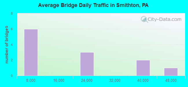
- 182,205Total average daily traffic
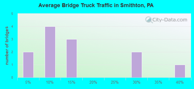
- 36,396Total average daily truck traffic
- National Bridge Inventory (NBI) Registered Bridges for Smithton
- No street view available for this location
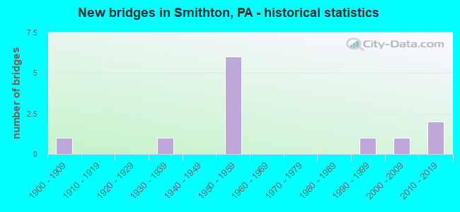
- New bridges - historical statistics
- 11900-1909
- 11930-1939
- 61950-1959
- 11990-1999
- 12000-2009
- 22010-2019
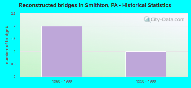
- Reconstructed bridges - Historical Statistics
- 21980-1989
- 11990-1999
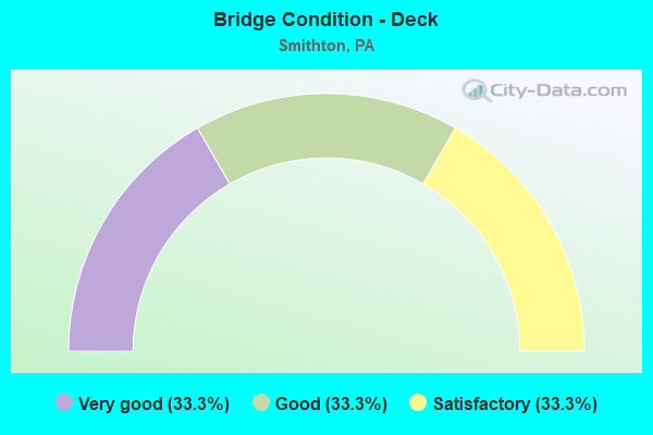
- Bridge Condition - Deck
- 33.3%Very good
- 33.3%Good
- 33.3%Satisfactory
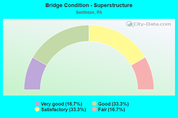
- Bridge Condition - Superstructure
- 16.7%Very good
- 33.3%Good
- 33.3%Satisfactory
- 16.7%Fair
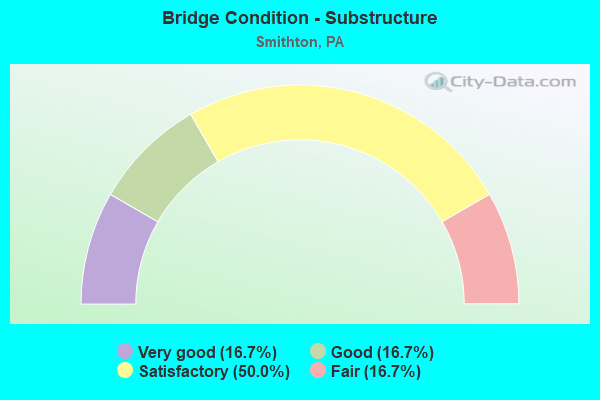
- Bridge Condition - Substructure
- 16.7%Very good
- 16.7%Good
- 50.0%Satisfactory
- 16.7%Fair
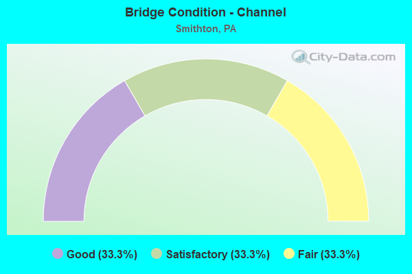
- Bridge Condition - Channel
- 33.3%Good
- 33.3%Satisfactory
- 33.3%Fair
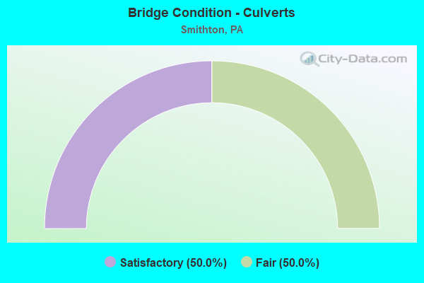
- Bridge Condition - Culverts
- 50.0%Satisfactory
- 50.0%Fair
Find on map >> Show street view
Structure Number: 35991, Location: ROSTRAVER TOWNSHIP (Lat: 40.155019, Lng: -79.776006), Route carried "on" structure: State highway 51, Year Built: 1954, Year Reconstructed: 1989, Status: Temporarily open, Structure Length: 4.15m (13.62ft), Average Daily Traffic: 17,358 (year 2022), Truck Traffic: 9%, Average Future Daily Traffic: 23,829 (year 2032), Design Load: HS 20+Mod, Features Intersected: SR 0070
Minimum Vertical Clearance: 30+ m (98+ ft), Kilometerpoint: 2.813, Lanes on structure: 4, Lanes under structure: 8, Base Highway Network: Yes, Owner: State Highway Agency, Approaching Roadway Width: 19.5m (64.0ft), Skew: 20 degrees, Material/Design: Steel, Design/Construction: Stringer/Multi-beam, Number Of Spans In Main Unit: 1, Number Of Approach Spans: 2, Length of Maximum Span: 23.2m (76.1ft), Curb or Sidewalk Widths: Left: 0.2m (0.7ft), Right: 0.2m (0.7ft), Curb-To-Curb Width: 21.4m (70.2ft), Out-to-Out Width: 22.2m (72.8ft)
Condition: Deck: Good, Superstructure: Satisfactory, Substructure: Satisfactory, Operating Rating: 68.0 metric tons, Method Used To Determine Operating Rating: Load Factor (LF), Inventory Rating: 40.8 metric tons, Method Used To Determine Inventory Rating: Load Factor (LF), Structural Evaluation: Equal to present minimum criteria, Deck Geometry: Superior to present desirable criteria, Underclear: High priority of corrective action, Approach Roadway Alignment: Equal to present desirable criteria, Length Of Structure Improvement: 4.10m (13.45ft), Designated Inspection Frequency: Every 24 months, Other Special Inspection Frequency: Every 6 months, Inspection Date: May 2021, Other Special Inspection Date: December 2017, Bridge Improvement Cost: $48,000, Roadway Improvement Cost: $200,000, Total Project Cost: $643,000, Deck Structure Type: Concrete Cast-file-Place, Wearing Surface/Protective System: Wearing Surface: Monolithic Concrete, Deck Protection: Epoxy Coated Reinforcing
Find on map >> Show street view
Structure Number: 36047, Location: ROSTRAVER TOWNSHIP (Lat: 40.153894, Lng: -79.780344), Route carried "on" structure: Interstate 70, Year Built: 1954, Status: Open, Structure Length: 0.61m (2.00ft), Average Daily Traffic: 33,230 (year 2021), Truck Traffic: 29%, Average Future Daily Traffic: 36,337 (year 2032), Design Load: HS 20+Mod, Features Intersected: CEDAR CREEK
Minimum Vertical Clearance: 30+ m (98+ ft), Kilometerpoint: 8.584, Lanes on structure: 4, Base Highway Network: Yes, Owner: State Highway Agency, Approaching Roadway Width: 21.9m (71.9ft), Skew: 30 degrees, Material/Design: Concrete, Design/Construction: Culvert, Number Of Spans In Main Unit: 1, Length of Maximum Span: 6.1m (20.0ft)
Condition: Channel: Fair, Culverts: Satisfactory, Operating Rating: 44.5 metric tons, Method Used To Determine Operating Rating: Field evaluation and documented engineering judgment, Inventory Rating: 32.7 metric tons, Method Used To Determine Inventory Rating: Field evaluation and documented engineering judgment, Structural Evaluation: Equal to present minimum criteria, Waterway Adequacy: Superior to present desirable criteria, Approach Roadway Alignment: Equal to present desirable criteria, Length Of Structure Improvement: 1.20m (3.94ft), Designated Inspection Frequency: Every 48 months, Inspection Date: May 2021
Find on map >> Show street view
Structure Number: 36053, Location: SMITHTON HI-LEVEL BRIDGE (Lat: 40.162292, Lng: -79.758106), Route carried "on" structure: Interstate 70, Year Built: 1956, Year Reconstructed: 2002, Status: Open, Structure Length: 41.30m (135.50ft), Average Daily Traffic: 43,549 (year 2022), Truck Traffic: 13%, Average Future Daily Traffic: 20,194 (year 2032), Design Load: HS 25 or greater, Features Intersected: CSXT R/R, TWP RD, YOUGH
Minimum Vertical Clearance: 30+ m (98+ ft), Kilometerpoint: 10.824, Lanes on structure: 4, Lanes under structure: 2, Base Highway Network: Yes, Owner: State Highway Agency, Approaching Roadway Width: 21.0m (68.9ft), Skew: 30 degrees, Material/Design: Steel continuous, Design/Construction: Truss - Deck, Number Of Spans In Main Unit: 6, Number Of Approach Spans: 2, Length of Maximum Span: 87.8m (288.1ft), Curb or Sidewalk Widths: Left: 0.2m (0.7ft), Right: 0.2m (0.7ft), Curb-To-Curb Width: 19.5m (64.0ft), Out-to-Out Width: 21.0m (68.9ft)
Condition: Deck: Satisfactory, Superstructure: Fair, Substructure: Satisfactory, Channel: Good, Operating Rating: 46.3 metric tons, Method Used To Determine Operating Rating: Load Factor (LF), Inventory Rating: 27.2 metric tons, Method Used To Determine Inventory Rating: Load Factor (LF), Structural Evaluation: Somewhat better than minimum adequacy, Deck Geometry: Somewhat better than minimum adequacy, Underclear: High priority of corrective action, Waterway Adequacy: Superior to present desirable criteria, Approach Roadway Alignment: Equal to present desirable criteria, Length Of Structure Improvement: 41.30m (135.50ft), Designated Inspection Frequency: Every 24 months, Critical Feature Inspection Frequency: Every 24 months, Underwater Inspection Frequency: Every 60 months, Inspection Date: September 2021, Critical Feature Inspection Date: September 2021, Underwater Inspection Date: September 2018, Deck Structure Type: Concrete Cast-file-Place, Wearing Surface/Protective System: Wearing Surface: Monolithic Concrete, Deck Protection: Epoxy Coated Reinforcing
Find on map >> Show street view
Structure Number: 36288, Location: ROSTRAVER & S. HUNTINGDON (Lat: 40.157008, Lng: -79.744603), Route carried "on" structure: State highway 981, Year Built: 1900, Year Reconstructed: 1986, Status: Open, Structure Length: 21.95m (72.01ft), Average Daily Traffic: 2,160 (year 2020), Truck Traffic: 7%, Average Future Daily Traffic: 3,653 (year 2032), Design Load: HS 25 or greater, Features Intersected: YOUGHIOGHENY RIV/BIKE TR
Minimum Vertical Clearance: 30+ m (98+ ft), Kilometerpoint: 1.962, Lanes on structure: 2, Owner: State Highway Agency, Approaching Roadway Width: 8.5m (27.9ft), Material/Design: Steel continuous, Design/Construction: Stringer/Multi-beam, Number Of Spans In Main Unit: 4, Length of Maximum Span: 72.5m (237.9ft), Curb or Sidewalk Widths: Left: 0.3m (1.0ft), Right: 1.5m (4.9ft), Curb-To-Curb Width: 8.5m (27.9ft), Out-to-Out Width: 10.8m (35.4ft)
Condition: Deck: Satisfactory, Superstructure: Satisfactory, Substructure: Satisfactory, Channel: Good, Operating Rating: 68.0 metric tons, Method Used To Determine Operating Rating: Load Factor (LF), Inventory Rating: 40.8 metric tons, Method Used To Determine Inventory Rating: Load Factor (LF), Structural Evaluation: Equal to present minimum criteria, Deck Geometry: Meets minimum limits, Waterway Adequacy: Superior to present desirable criteria, Approach Roadway Alignment: Better than present minimum criteria, Length Of Structure Improvement: 22.30m (73.16ft), Designated Inspection Frequency: Every 24 months, Inspection Date: July 2021, Bridge Improvement Cost: $262,000, Roadway Improvement Cost: $772,000, Total Project Cost: $3,538,000, Deck Structure Type: Concrete Cast-file-Place, Wearing Surface/Protective System: Wearing Surface: Monolithic Concrete, Deck Protection: Epoxy Coated Reinforcing
Find on map >> Show street view
Structure Number: 36289, Location: SOUTH HUNTINGDON TOWNSHIP (Lat: 40.156389, Lng: -79.742178), Route carried "on" structure: State highway 981, Year Built: 1931, Status: Open, Structure Length: 0.76m (2.49ft), Average Daily Traffic: 2,160 (year 2020), Truck Traffic: 7%, Average Future Daily Traffic: 3,653 (year 2032), Design Load: HS 20+Mod, Features Intersected: BARREN RUN
Minimum Vertical Clearance: 30+ m (98+ ft), Kilometerpoint: 2.939, Lanes on structure: 2, Owner: State Highway Agency, Approaching Roadway Width: 9.1m (29.9ft), Skew: 1 degrees, Material/Design: Concrete, Design/Construction: Culvert, Number Of Spans In Main Unit: 1, Length of Maximum Span: 6.1m (20.0ft)
Condition: Channel: Fair, Culverts: Fair, Operating Rating: 75.3 metric tons, Method Used To Determine Operating Rating: Field evaluation and documented engineering judgment, Inventory Rating: 45.4 metric tons, Method Used To Determine Inventory Rating: Field evaluation and documented engineering judgment, Structural Evaluation: Somewhat better than minimum adequacy, Waterway Adequacy: Equal to present minimum criteria, Approach Roadway Alignment: Equal to present desirable criteria, Length Of Structure Improvement: 0.70m (2.30ft), Designated Inspection Frequency: Every 24 months, Inspection Date: July 2021, Bridge Improvement Cost: $21,000, Roadway Improvement Cost: $150,000, Total Project Cost: $285,000
Find on map >> Show street view
Structure Number: 36878, Location: HALF MILE WEST OF SR51 (Lat: 40.153211, Lng: -79.780031), Route carried "on" structure: City street 7103, Year Built: 1993, Status: Open, Structure Length: 1.01m (3.31ft), Average Daily Traffic: 910 (year 2004), Truck Traffic: 2%, Average Future Daily Traffic: 2,800 (year 2010), Design Load: HS 25 or greater, Features Intersected: CEDAR CREEK, Facility Carried by Structure: FINLEY ROAD
Minimum Vertical Clearance: 30+ m (98+ ft), Kilometerpoint: 0.000, Lanes on structure: 2, Owner: Town or Township Highway Agency, Approaching Roadway Width: 7.3m (24.0ft), Material/Design: Prestressed concrete, Design/Construction: Box Beam or Girders - Single/Spread, Number Of Spans In Main Unit: 1, Length of Maximum Span: 9.8m (32.2ft), Curb or Sidewalk Widths: Left: 0.2m (0.7ft), Right: 0.2m (0.7ft), Curb-To-Curb Width: 9.1m (29.9ft), Out-to-Out Width: 10.2m (33.5ft)
Condition: Deck: Good, Superstructure: Good, Substructure: Fair, Channel: Satisfactory, Operating Rating: 90.7 metric tons, Method Used To Determine Operating Rating: Load Factor (LF), Inventory Rating: 53.5 metric tons, Method Used To Determine Inventory Rating: Load Factor (LF), Structural Evaluation: Somewhat better than minimum adequacy, Deck Geometry: Equal to present minimum criteria, Waterway Adequacy: Superior to present desirable criteria, Approach Roadway Alignment: Equal to present desirable criteria, Length Of Structure Improvement: 1.00m (3.28ft), Designated Inspection Frequency: Every 24 months, Inspection Date: October 2020, Bridge Improvement Cost: $6,000, Roadway Improvement Cost: $18,000, Total Project Cost: $81,000, Deck Structure Type: Corrugated Steel, Wearing Surface/Protective System: Wearing Surface: Monolithic Concrete, Deck Protection: Epoxy Coated Reinforcing
Find on map >> Show street view
Structure Number: 44136, Location: SOUTH HUNTINGDON TWP (Lat: 40.155419, Lng: -79.737089), Route carried "on" structure: State highway , Year Built: 2004, Status: Open, Structure Length: 1.10m (3.61ft), Average Daily Traffic: 2,155 (year 2020), Truck Traffic: 5%, Average Future Daily Traffic: 3,117 (year 2032), Design Load: HL 93, Features Intersected: Dutch Hollow Creek, Facility Carried by Structure: SR 3031
Minimum Vertical Clearance: 30+ m (98+ ft), Kilometerpoint: 0.000, Lanes on structure: 2, Owner: State Highway Agency, Approaching Roadway Width: 12.7m (41.7ft), Skew: 2 degrees, Material/Design: Prestressed concrete, Design/Construction: Box Beam or Girders - Single/Spread, Number Of Spans In Main Unit: 1, Length of Maximum Span: 10.4m (34.1ft), Curb-To-Curb Width: 12.7m (41.7ft), Out-to-Out Width: 13.7m (44.9ft)
Condition: Deck: Very good, Superstructure: Good, Substructure: Good, Channel: Satisfactory, Operating Rating: 66.7 metric tons, Method Used To Determine Operating Rating: Assigned ratings based on Load and Resistance Factor Design (LRFD) reported by rating factor (RF) using HL93 loadings, Inventory Rating: 36.9 metric tons, Method Used To Determine Inventory Rating: Assigned ratings based on Load and Resistance Factor Design (LRFD) reported by rating factor (RF) using HL93 loadings, Structural Evaluation: Better than present minimum criteria, Deck Geometry: Equal to present minimum criteria, Waterway Adequacy: Superior to present desirable criteria, Approach Roadway Alignment: Equal to present desirable criteria, Designated Inspection Frequency: Every 48 months, Inspection Date: January 2020, Deck Structure Type: Concrete Cast-file-Place, Wearing Surface/Protective System: Wearing Surface: Monolithic Concrete, Deck Protection: Epoxy Coated Reinforcing
Find on map >> Show street view
Structure Number: 47335, Location: exit 49 on SR 0070 (Lat: 40.168183, Lng: -79.732675), Route carried "on" structure: Interstate 70, Year Built: 2012, Status: Open, Structure Length: 5.27m (17.29ft), Average Daily Traffic: 34,939 (year 2022), Truck Traffic: 37%, Average Future Daily Traffic: 20,194 (year 2032), Design Load: HL 93, Features Intersected: SR 3031
Minimum Vertical Clearance: 30+ m (98+ ft), Kilometerpoint: 12.624, Lanes on structure: 5, Lanes under structure: 3, Base Highway Network: Yes, Owner: State Highway Agency, Approaching Roadway Width: 20.7m (67.9ft), Skew: 33 degrees, Material/Design: Prestressed concrete continuous, Design/Construction: Box Beam or Girders - Single/Spread, Number Of Spans In Main Unit: 2, Number Of Approach Spans: 1, Length of Maximum Span: 25.6m (84.0ft), Curb or Sidewalk Widths: Left: 0.1m (0.3ft), Right: 0.1m (0.3ft), Curb-To-Curb Width: 32.9m (107.9ft), Out-to-Out Width: 34.1m (111.9ft)
Condition: Deck: Very good, Superstructure: Very good, Substructure: Very good, Operating Rating: 57.3 metric tons, Method Used To Determine Operating Rating: Assigned ratings based on Load and Resistance Factor Design (LRFD) reported by rating factor (RF) using HL93 loadings, Inventory Rating: 36.0 metric tons, Method Used To Determine Inventory Rating: Assigned ratings based on Load and Resistance Factor Design (LRFD) reported by rating factor (RF) using HL93 loadings, Structural Evaluation: Equal to present desirable criteria, Deck Geometry: Superior to present desirable criteria, Underclear: Superior to present desirable criteria, Approach Roadway Alignment: Equal to present desirable criteria, Designated Inspection Frequency: Every 48 months, Inspection Date: May 2021, Deck Structure Type: Concrete Cast-file-Place, Wearing Surface/Protective System: Wearing Surface: Monolithic Concrete, Deck Protection: Epoxy Coated Reinforcing
Find on map >> Show street view
Structure Number: 35991, Location: ROSTRAVER TOWNSHIP (Lat: 40.155019, Lng: -79.776006), Route carried "under" structure: Interstate 70, Year Built: 1954, Structure Length: 0. m, Average Daily Traffic: 21,859 (year 2022), Truck Traffic: 12%, Features Intersected: SR 0070, Facility Carried by Structure: SR 0051
Minimum Vertical Clearance: 4.44m (14.57ft), Kilometerpoint: 8.597, Lanes on structure: 4, Lanes under structure: 4, Material/Design: Steel, Design/Construction: Stringer/Multi-beam, Length of Maximum Span: 23.2m (76.1ft)
Find on map >> Show street view
Structure Number: 35991, Location: ROSTRAVER TOWNSHIP (Lat: 40.155019, Lng: -79.776006), Route carried "under" structure: Interstate 70, Year Built: 1954, Structure Length: 0. m, Average Daily Traffic: 21,690 (year 2022), Truck Traffic: 14%, Features Intersected: SR 0070, Facility Carried by Structure: SR 0051
Minimum Vertical Clearance: 4.65m (15.26ft), Kilometerpoint: 8.584, Lanes on structure: 4, Lanes under structure: 4, Material/Design: Steel, Design/Construction: Stringer/Multi-beam, Length of Maximum Span: 23.2m (76.1ft)
Find on map >> Show street view
Structure Number: 36053, Location: SMITHTON HI-LEVEL BRIDGE (Lat: 40.162292, Lng: -79.758106), Route carried "under" structure: City street , Year Built: 1956, Structure Length: 0. m, Average Daily Traffic: 100 (year 2015), Truck Traffic: 1%, Features Intersected: CSXT R/R, TWP RD, YOUGH, Facility Carried by Structure: SR 0070
Minimum Vertical Clearance: 10.03m (32.91ft), Kilometerpoint: 0.000, Lanes on structure: 4, Lanes under structure: 2, Material/Design: Steel continuous, Design/Construction: Truss - Deck, Length of Maximum Span: 87.8m (288.1ft)
Find on map >> Show street view
Structure Number: 47335, Location: exit 49 on SR 0070 (Lat: 40.168183, Lng: -79.732675), Route carried "under" structure: State highway , Year Built: 2012, Structure Length: 0. m, Average Daily Traffic: 2,095 (year 2022), Truck Traffic: 25%, Features Intersected: SR 3031, Facility Carried by Structure: SR 0070
Minimum Vertical Clearance: 5.69m (18.67ft), Kilometerpoint: 0.781, Lanes on structure: 5, Lanes under structure: 3, Material/Design: Prestressed concrete continuous, Design/Construction: Box Beam or Girders - Single/Spread, Length of Maximum Span: 25.6m (84.0ft)