Bridge Statistics for Somerset, Massachusetts (MA)
Condition, Traffic, Stress, Structural Evaluation, Project Costs
- National Bridge Inventory (NBI) Statistics
- 14Number of bridges
- 167ft / 50.9mTotal length
- $49,522,000Total costs
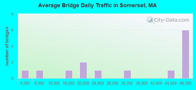
- 418,565Total average daily traffic
- 14,257Total average daily truck traffic
- National Bridge Inventory (NBI) Registered Bridges for Somerset
- No street view available for this location
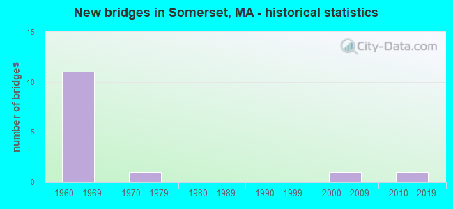
- New bridges - historical statistics
- 111960-1969
- 11970-1979
- 12000-2009
- 12010-2019
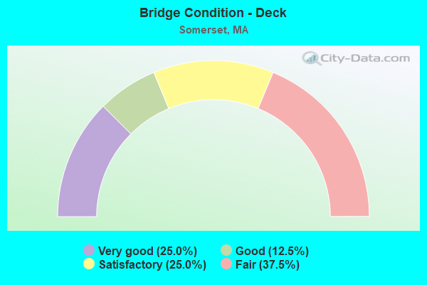
- Bridge Condition - Deck
- 25.0%Very good
- 12.5%Good
- 25.0%Satisfactory
- 37.5%Fair
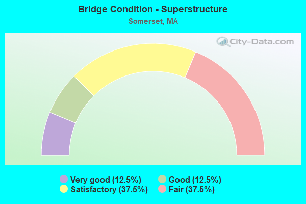
- Bridge Condition - Superstructure
- 12.5%Very good
- 12.5%Good
- 37.5%Satisfactory
- 37.5%Fair
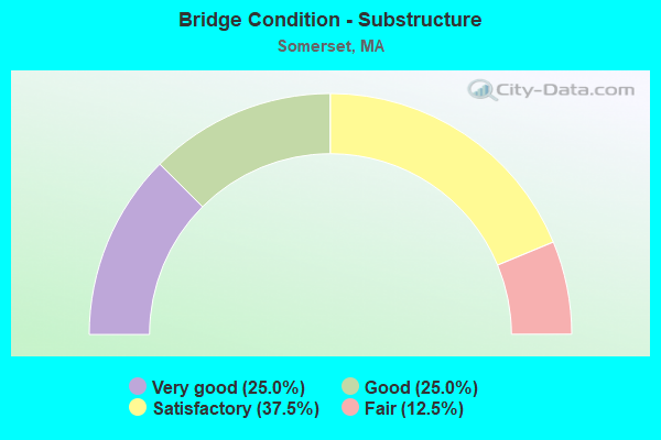
- Bridge Condition - Substructure
- 25.0%Very good
- 25.0%Good
- 37.5%Satisfactory
- 12.5%Fair

- Bridge Condition - Channel
- 25.0%Very good
- 75.0%Satisfactory
Find on map >> Show street view
Structure Number: S16003AVGDOTNBI, Location: AT SWANSEA T.L. (Lat: 41.728111, Lng: -71.191878), Route carried "on" structure: State highway 103, Year Built: 2009, Status: Open, Structure Length: 3.42m (11.22ft), Average Daily Traffic: 15,900 (year 2021), Truck Traffic: 8%, Average Future Daily Traffic: 25,269 (year 2032), Design Load: HS 20, Features Intersected: WATER LEES RIVER
Minimum Vertical Clearance: 30+ m (98+ ft), Kilometerpoint: 4.570, Lanes on structure: 2, Owner: State Highway Agency, Approaching Roadway Width: 9.9m (32.5ft), Material/Design: Prestressed concrete, Design/Construction: Stringer/Multi-beam, Number Of Spans In Main Unit: 1, Length of Maximum Span: 33.0m (108.3ft), Curb or Sidewalk Widths: Left: 1.6m (5.2ft), Right: 0.1m (0.3ft), Curb-To-Curb Width: 9.9m (32.5ft), Out-to-Out Width: 12.4m (40.7ft)
Condition: Deck: Very good, Superstructure: Good, Substructure: Very good, Channel: Very good, Operating Rating: 71.8 metric tons, Method Used To Determine Operating Rating: Load Factor (LF), Inventory Rating: 43.0 metric tons, Method Used To Determine Inventory Rating: Load Factor (LF), Structural Evaluation: Better than present minimum criteria, Deck Geometry: Meets minimum limits, Waterway Adequacy: Equal to present desirable criteria, Approach Roadway Alignment: Equal to present desirable criteria, Length Of Structure Improvement: 3.50m (11.48ft), Designated Inspection Frequency: Every 24 months, Inspection Date: June 2021, Bridge Improvement Cost: $1,155,000, Roadway Improvement Cost: $116,000, Total Project Cost: $1,733,000 ( Estimate for 2022), Deck Structure Type: Concrete Cast-file-Place, Wearing Surface/Protective System: Wearing Surface: Integral Concrete, Deck Protection: Epoxy Coated Reinforcing
Find on map >> Show street view
Structure Number: S160073N4DOTNBI, Location: AT SWANSEA T.L. (Lat: 41.740444, Lng: -71.186800), Route carried "on" structure: US 6, Year Built: 1970, Status: Open, Structure Length: 0.79m (2.59ft), Average Daily Traffic: 18,265 (year 2019), Truck Traffic: 6%, Average Future Daily Traffic: 31,586 (year 2031), Design Load: H 20, Features Intersected: WATER LEES RIVER
Minimum Vertical Clearance: 30+ m (98+ ft), Kilometerpoint: 14.939, Lanes on structure: 4, Owner: State Highway Agency, Approaching Roadway Width: 15.8m (51.8ft), Skew: 6 degrees, Material/Design: Prestressed concrete, Design/Construction: Slab, Number Of Spans In Main Unit: 1, Length of Maximum Span: 7.9m (25.9ft), Curb or Sidewalk Widths: Left: 0.0m, Right: 1.6m (5.2ft), Curb-To-Curb Width: 15.8m (51.8ft), Out-to-Out Width: 18.6m (61.0ft)
Condition: Deck: Fair, Superstructure: Fair, Substructure: Satisfactory, Channel: Satisfactory, Operating Rating: 63.3 metric tons, Method Used To Determine Operating Rating: Load Factor (LF), Inventory Rating: 37.9 metric tons, Method Used To Determine Inventory Rating: Load Factor (LF), Structural Evaluation: Somewhat better than minimum adequacy, Deck Geometry: Meets minimum limits, Waterway Adequacy: Equal to present desirable criteria, Approach Roadway Alignment: Equal to present desirable criteria, Length Of Structure Improvement: 0.80m (2.62ft), Designated Inspection Frequency: Every 24 months, Underwater Inspection Frequency: Every 36 months, Inspection Date: March 2020, Underwater Inspection Date: January 2020, Bridge Improvement Cost: $585,000, Roadway Improvement Cost: $59,000, Total Project Cost: $878,000 ( Estimate for 2022), Deck Structure Type: Concrete Precast Panels, Wearing Surface/Protective System: Wearing Surface: Bituminous, Membrane: Built-up
Find on map >> Show street view
Structure Number: S160093Y9DOTNBI, Location: 1.3MI W OF FALL RIVER C.L (Lat: 41.718853, Lng: -71.182839), Route carried "on" structure: City street , Year Built: 1960, Status: Open, Structure Length: 11.06m (36.29ft), Average Daily Traffic: 2,600 (year 2021), Truck Traffic: 12%, Average Future Daily Traffic: 9,476 (year 2032), Design Load: HS 20+Mod, Features Intersected: I 195, Facility Carried by Structure: HWY BRYTN PNT RD
Minimum Vertical Clearance: 30+ m (98+ ft), Kilometerpoint: 0.010, Lanes on structure: 2, Lanes under structure: 6, Owner: State Highway Agency, Approaching Roadway Width: 8.5m (27.9ft), Skew: 3 degrees, Material/Design: Steel, Design/Construction: Stringer/Multi-beam, Number Of Spans In Main Unit: 5, Length of Maximum Span: 30.2m (99.1ft), Curb or Sidewalk Widths: Left: 0.5m (1.6ft), Right: 1.5m (4.9ft), Curb-To-Curb Width: 8.5m (27.9ft), Out-to-Out Width: 11.1m (36.4ft)
Condition: Deck: Fair, Superstructure: Satisfactory, Substructure: Satisfactory, Inventory Rating: 74.2 metric tons, Method Used To Determine Inventory Rating: Load Factor (LF), Structural Evaluation: Equal to present minimum criteria, Deck Geometry: Meets minimum limits, Underclear: High priority of corrective action, Approach Roadway Alignment: Equal to present desirable criteria, Length Of Structure Improvement: 11.10m (36.42ft), Designated Inspection Frequency: Every 24 months, Inspection Date: December 2021, Bridge Improvement Cost: $9,000,000, Roadway Improvement Cost: $901,000, Total Project Cost: $13,501,000 ( Estimate for 2022), Deck Structure Type: Concrete Cast-file-Place, Wearing Surface/Protective System: Wearing Surface: Monolithic Concrete
Find on map >> Show street view
Structure Number: S160103PDDOTNBI, Location: .4 MI FROM SWANSEA T.L. (Lat: 41.725972, Lng: -71.185889), Route carried "on" structure: State highway 103, Year Built: 1960, Status: Open, Structure Length: 13.50m (44.29ft), Average Daily Traffic: 16,400 (year 2021), Truck Traffic: 10%, Average Future Daily Traffic: 56,223 (year 2032), Design Load: HS 20, Features Intersected: I 195
Minimum Vertical Clearance: 30+ m (98+ ft), Kilometerpoint: 5.052, Lanes on structure: 2, Lanes under structure: 8, Owner: State Highway Agency, Approaching Roadway Width: 14.6m (47.9ft), Skew: 4 degrees, Material/Design: Steel, Design/Construction: Stringer/Multi-beam, Number Of Spans In Main Unit: 5, Length of Maximum Span: 37.8m (124.0ft), Curb or Sidewalk Widths: Left: 0.4m (1.3ft), Right: 1.3m (4.3ft), Curb-To-Curb Width: 14.6m (47.9ft), Out-to-Out Width: 17.2m (56.4ft)
Condition: Deck: Satisfactory, Superstructure: Fair, Substructure: Fair, Operating Rating: 53.9 metric tons, Method Used To Determine Operating Rating: Load Factor (LF), Inventory Rating: 32.3 metric tons, Method Used To Determine Inventory Rating: Load Factor (LF), Structural Evaluation: Somewhat better than minimum adequacy, Deck Geometry: Superior to present desirable criteria, Underclear: High priority of corrective action, Approach Roadway Alignment: Equal to present desirable criteria, Length Of Structure Improvement: 13.60m (44.62ft), Designated Inspection Frequency: Every 24 months, Inspection Date: June 2021, Bridge Improvement Cost: $9,189,000, Roadway Improvement Cost: $919,000, Total Project Cost: $13,784,000 ( Estimate for 2022), Deck Structure Type: Concrete Cast-file-Place, Wearing Surface/Protective System: Wearing Surface: Bituminous, Membrane: Built-up
Find on map >> Show street view
Structure Number: S160113YADOTNBI, Location: .1 MI N OF ST 103 (Lat: 41.728806, Lng: -71.188381), Route carried "on" structure: City street , Year Built: 1960, Status: Open, Structure Length: 8.63m (28.31ft), Average Daily Traffic: 7,400 (year 2021), Truck Traffic: 10%, Average Future Daily Traffic: 30,638 (year 2032), Design Load: H 20, Features Intersected: I 195, Facility Carried by Structure: HWY LEES RIV AVE
Minimum Vertical Clearance: 30+ m (98+ ft), Kilometerpoint: 15.498, Lanes on structure: 2, Lanes under structure: 6, Owner: State Highway Agency, Approaching Roadway Width: 12.2m (40.0ft), Skew: 1 degrees, Material/Design: Steel, Design/Construction: Stringer/Multi-beam, Number Of Spans In Main Unit: 5, Length of Maximum Span: 22.8m (74.8ft), Curb or Sidewalk Widths: Left: 0.4m (1.3ft), Right: 1.5m (4.9ft), Curb-To-Curb Width: 12.2m (40.0ft), Out-to-Out Width: 14.7m (48.2ft)
Condition: Deck: Good, Superstructure: Fair, Substructure: Satisfactory, Operating Rating: 59.1 metric tons, Method Used To Determine Operating Rating: Load Factor (LF), Inventory Rating: 35.4 metric tons, Method Used To Determine Inventory Rating: Load Factor (LF), Structural Evaluation: Somewhat better than minimum adequacy, Deck Geometry: Somewhat better than minimum adequacy, Underclear: High priority of corrective action, Approach Roadway Alignment: Equal to present desirable criteria, Length Of Structure Improvement: 8.70m (28.54ft), Designated Inspection Frequency: Every 24 months, Inspection Date: May 2021, Bridge Improvement Cost: $5,051,000, Roadway Improvement Cost: $506,000, Total Project Cost: $7,577,000 ( Estimate for 2022), Deck Structure Type: Concrete Cast-file-Place, Wearing Surface/Protective System: Wearing Surface: Monolithic Concrete, Deck Protection: Epoxy Coated Reinforcing
Find on map >> Show street view
Structure Number: S160123U6DOTNBI, Location: OVER LEES RIVER (Lat: 41.730919, Lng: -71.191703), Route carried "on" structure: Interstate 195, Year Built: 1960, Status: Open, Structure Length: 4.15m (13.62ft), Average Daily Traffic: 29,000 (year 2016), Truck Traffic: 11%, Average Future Daily Traffic: 105,971 (year 2031), Design Load: H 20, Features Intersected: WATER LEES RIVER
Minimum Vertical Clearance: 30+ m (98+ ft), Kilometerpoint: 6.437, Lanes on structure: 4, Base Highway Network: Yes, Owner: State Highway Agency, Approaching Roadway Width: 15.2m (49.9ft), Skew: 2 degrees, Material/Design: Steel, Design/Construction: Stringer/Multi-beam, Number Of Spans In Main Unit: 1, Length of Maximum Span: 38.1m (125.0ft), Curb or Sidewalk Widths: Left: 0.8m (2.6ft), Right: 0.8m (2.6ft), Curb-To-Curb Width: 15.2m (49.9ft), Out-to-Out Width: 18.3m (60.0ft)
Condition: Deck: Satisfactory, Superstructure: Satisfactory, Substructure: Good, Channel: Satisfactory, Operating Rating: 62.9 metric tons, Method Used To Determine Operating Rating: Load Factor (LF), Inventory Rating: 37.7 metric tons, Method Used To Determine Inventory Rating: Load Factor (LF), Structural Evaluation: Equal to present minimum criteria, Deck Geometry: High priority of replacement, Waterway Adequacy: Equal to present desirable criteria, Approach Roadway Alignment: Equal to present minimum criteria, Length Of Structure Improvement: 4.20m (13.78ft), Designated Inspection Frequency: Every 24 months, Inspection Date: October 2020, Bridge Improvement Cost: $2,733,000, Roadway Improvement Cost: $274,000, Total Project Cost: $4,100,000 ( Estimate for 2022), Deck Structure Type: Concrete Cast-file-Place, Wearing Surface/Protective System: Wearing Surface: Bituminous, Membrane: Built-up
Find on map >> Show street view
Structure Number: S160123U7DOTNBI, Location: I195 AT SWANSEA T.L. (Lat: 41.730478, Lng: -71.191792), Route carried "on" structure: Interstate 195, Year Built: 1960, Status: Open, Structure Length: 4.15m (13.62ft), Average Daily Traffic: 40,000 (year 2016), Truck Traffic: 13%, Average Future Daily Traffic: 105,971 (year 2031), Design Load: H 20, Features Intersected: WATER LEES RIVER
Minimum Vertical Clearance: 30+ m (98+ ft), Kilometerpoint: 6.437, Lanes on structure: 4, Base Highway Network: Yes, Owner: State Highway Agency, Approaching Roadway Width: 15.2m (49.9ft), Skew: 2 degrees, Material/Design: Steel, Design/Construction: Stringer/Multi-beam, Number Of Spans In Main Unit: 1, Length of Maximum Span: 38.1m (125.0ft), Curb or Sidewalk Widths: Left: 0.8m (2.6ft), Right: 0.8m (2.6ft), Curb-To-Curb Width: 15.2m (49.9ft), Out-to-Out Width: 18.3m (60.0ft)
Condition: Deck: Fair, Superstructure: Satisfactory, Substructure: Good, Channel: Satisfactory, Operating Rating: 62.9 metric tons, Method Used To Determine Operating Rating: Load Factor (LF), Inventory Rating: 37.7 metric tons, Method Used To Determine Inventory Rating: Load Factor (LF), Structural Evaluation: Equal to present minimum criteria, Deck Geometry: High priority of replacement, Waterway Adequacy: Equal to present desirable criteria, Approach Roadway Alignment: Equal to present desirable criteria, Length Of Structure Improvement: 4.20m (13.78ft), Designated Inspection Frequency: Every 24 months, Inspection Date: October 2020, Bridge Improvement Cost: $5,148,000, Roadway Improvement Cost: $515,000, Total Project Cost: $7,723,000 ( Estimate for 2022), Deck Structure Type: Concrete Cast-file-Place, Wearing Surface/Protective System: Wearing Surface: Bituminous, Membrane: Built-up
Find on map >> Show street view
Structure Number: S16013AG0DOTNBI, Location: WEST OF TAUNTON RIVER (Lat: 41.727806, Lng: -71.155994), Route carried "on" structure: US 6, Year Built: 2011, Status: Open, Structure Length: 5.24m (17.19ft), Average Daily Traffic: 20,200 (year 2019), Truck Traffic: 4%, Average Future Daily Traffic: 56,223 (year 2032), Design Load: HS 20, Features Intersected: ST138 RIVERSIDE AVE
Minimum Vertical Clearance: 30+ m (98+ ft), Kilometerpoint: 0.000, Lanes on structure: 5, Lanes under structure: 2, Base Highway Network: Yes, Owner: State Highway Agency, Approaching Roadway Width: 25.5m (83.7ft), Skew: 31 degrees, Material/Design: Prestressed concrete continuous, Design/Construction: Box Beam or Girders - Single/Spread, Number Of Spans In Main Unit: 3, Length of Maximum Span: 22.4m (73.5ft), Curb-To-Curb Width: 25.5m (83.7ft), Out-to-Out Width: 27.6m (90.6ft)
Condition: Deck: Very good, Superstructure: Very good, Substructure: Very good, Operating Rating: 77.8 metric tons, Method Used To Determine Operating Rating: Load Factor (LF), Inventory Rating: 46.6 metric tons, Method Used To Determine Inventory Rating: Load Factor (LF), Structural Evaluation: Equal to present desirable criteria, Deck Geometry: Superior to present desirable criteria, Underclear: Meets minimum limits, Approach Roadway Alignment: Equal to present desirable criteria, Length Of Structure Improvement: 5.30m (17.39ft), Designated Inspection Frequency: Every 24 months, Inspection Date: November 2021, Bridge Improvement Cost: $150,000, Roadway Improvement Cost: $16,000, Total Project Cost: $226,000 ( Estimate for 2022), Deck Structure Type: Concrete Cast-file-Place, Wearing Surface/Protective System: Wearing Surface: Bituminous, Membrane: Built-up, Deck Protection: Epoxy Coated Reinforcing
Find on map >> Show street view
Structure Number: S160093Y9DOTNBI, Location: 1.3MI W OF FALL RIVER C.L (Lat: 41.716667, Lng: -71.183333), Route carried "under" structure: Interstate 195, Year Built: 1960, Structure Length: 0. m, Average Daily Traffic: 44,800 (year 0000), Features Intersected: I 195 EB, Facility Carried by Structure: HWY BRATN PNT RD
Minimum Vertical Clearance: 4.39m (14.40ft), Kilometerpoint: 0.000, Lanes on structure: 3, Lanes under structure: 2, Material/Design: Steel, Design/Construction: Stringer/Multi-beam, Length of Maximum Span: 30.2m (99.1ft)
Find on map >> Show street view
Structure Number: S160093Y9DOTNBI, Location: 1.3MI W OF FALL RIVER C.L (Lat: 41.716667, Lng: -71.183333), Route carried "under" structure: Interstate 195, Year Built: 1960, Structure Length: 0. m, Average Daily Traffic: 44,800 (year 0000), Features Intersected: I 195 WB, Facility Carried by Structure: HWY BRTN PNT RD
Minimum Vertical Clearance: 4.39m (14.40ft), Kilometerpoint: 0.000, Lanes on structure: 3, Lanes under structure: 2, Material/Design: Steel, Design/Construction: Stringer/Multi-beam, Length of Maximum Span: 30.2m (99.1ft)
Find on map >> Show street view
Structure Number: S160103PDDOTNBI, Location: .4 MI FROM SWANSEA T.L. (Lat: 41.726403, Lng: -71.186428), Route carried "under" structure: Interstate 195, Year Built: 1960, Structure Length: 0. m, Average Daily Traffic: 44,800 (year 0000), Features Intersected: I 195 EB, Facility Carried by Structure: ST103
Minimum Vertical Clearance: 4.44m (14.57ft), Kilometerpoint: 0.000, Lanes on structure: 4, Lanes under structure: 2, Material/Design: Steel, Design/Construction: Stringer/Multi-beam, Length of Maximum Span: 37.8m (124.0ft)
Find on map >> Show street view
Structure Number: S160103PDDOTNBI, Location: .4 MI FROM SWANSEA T.L. (Lat: 41.725719, Lng: -71.185453), Route carried "under" structure: Interstate 195, Year Built: 1960, Structure Length: 0. m, Average Daily Traffic: 44,800 (year 0000), Features Intersected: I 195 WB, Facility Carried by Structure: ST103
Minimum Vertical Clearance: 4.44m (14.57ft), Kilometerpoint: 0.000, Lanes on structure: 4, Lanes under structure: 2, Material/Design: Steel, Design/Construction: Stringer/Multi-beam, Length of Maximum Span: 37.8m (124.0ft)
Find on map >> Show street view
Structure Number: S160113YADOTNBI, Location: .1 MI N OF ST 103 (Lat: 41.716667, Lng: -71.183333), Route carried "under" structure: Interstate 195, Year Built: 1960, Structure Length: 0. m, Average Daily Traffic: 44,800 (year 0000), Features Intersected: I 195 EB, Facility Carried by Structure: HWY LEES RIV AVE
Minimum Vertical Clearance: 4.47m (14.67ft), Kilometerpoint: 0.000, Lanes on structure: 3, Lanes under structure: 2, Material/Design: Steel, Design/Construction: Stringer/Multi-beam, Length of Maximum Span: 23.2m (76.1ft)
Find on map >> Show street view
Structure Number: S160113YADOTNBI, Location: .1 MI N OF ST 103 (Lat: 41.716667, Lng: -71.183333), Route carried "under" structure: Interstate 195, Year Built: 1960, Structure Length: 0. m, Average Daily Traffic: 44,800 (year 0000), Features Intersected: I 195 WB, Facility Carried by Structure: HWY LEES RIV AVE
Minimum Vertical Clearance: 4.47m (14.67ft), Kilometerpoint: 0.000, Lanes on structure: 3, Lanes under structure: 2, Material/Design: Steel, Design/Construction: Stringer/Multi-beam, Length of Maximum Span: 23.2m (76.1ft)