Bridge Statistics for South Amherst, Ohio (OH)
Condition, Traffic, Stress, Structural Evaluation, Project Costs
- National Bridge Inventory (NBI) Statistics
- 10Number of bridges
- 59ft / 17.9mTotal length
- $41,000Total costs
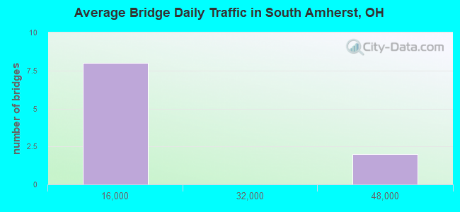
- 107,074Total average daily traffic
- 13,448Total average daily truck traffic
- National Bridge Inventory (NBI) Registered Bridges for South Amherst
- No street view available for this location
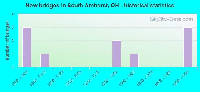
- New bridges - historical statistics
- 31900-1909
- 11910-1919
- 21950-1959
- 11960-1969
- 31990-1999

- Reconstructed bridges - Historical Statistics
- 11920-1929
- 01930-1939
- 01940-1949
- 11950-1959
- 01960-1969
- 01970-1979
- 01980-1989
- 21990-1999
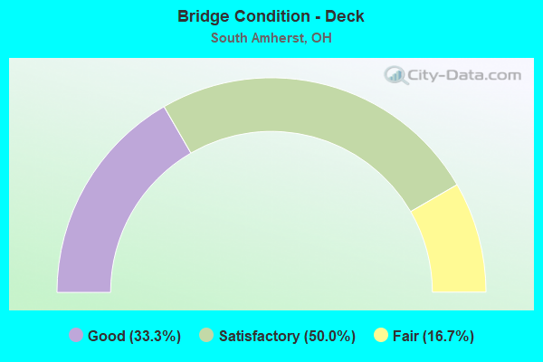
- Bridge Condition - Deck
- 33.3%Good
- 50.0%Satisfactory
- 16.7%Fair
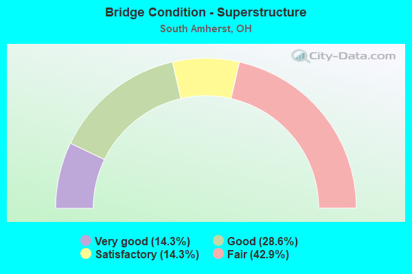
- Bridge Condition - Superstructure
- 14.3%Very good
- 28.6%Good
- 14.3%Satisfactory
- 42.9%Fair
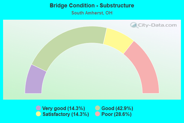
- Bridge Condition - Substructure
- 14.3%Very good
- 42.9%Good
- 14.3%Satisfactory
- 28.6%Poor
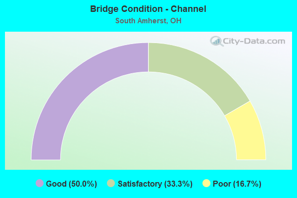
- Bridge Condition - Channel
- 50.0%Good
- 33.3%Satisfactory
- 16.7%Poor
Find on map >> Show street view
Structure Number: 4703308, Location: 3.29 MILES N OF SR 511 (Lat: 41.341831, Lng: -82.215950), Route carried "on" structure: State highway 58, Year Built: 1962, Status: Open, Structure Length: 0.64m (2.10ft), Average Daily Traffic: 8,073 (year 2015), Truck Traffic: 6%, Average Future Daily Traffic: 11,205 (year 2035), Design Load: HS 20, Features Intersected: SQUIRES SCHRAMM DITCH
Minimum Vertical Clearance: 30+ m (98+ ft), Kilometerpoint: 31.060, Lanes on structure: 2, Base Highway Network: Yes, Owner: State Highway Agency, Approaching Roadway Width: 11.0m (36.1ft), Skew: 3 degrees, Material/Design: Concrete, Design/Construction: Slab, Number Of Spans In Main Unit: 1, Length of Maximum Span: 5.5m (18.0ft), Curb-To-Curb Width: 11.6m (38.1ft), Out-to-Out Width: 12.2m (40.0ft)
Condition: Deck: Good, Superstructure: Good, Substructure: Good, Channel: Good, Operating Rating: 38.9 metric tons, Method Used To Determine Operating Rating: Allowable Stress (AS) rating reported by rating factor (RF) method using MS18 loading, Inventory Rating: 22.7 metric tons, Method Used To Determine Inventory Rating: Allowable Stress (AS) rating reported by rating factor (RF) method using MS18 loading, Structural Evaluation: Somewhat better than minimum adequacy, Deck Geometry: Somewhat better than minimum adequacy, Waterway Adequacy: Equal to present desirable criteria, Approach Roadway Alignment: Equal to present desirable criteria, Designated Inspection Frequency: Every 24 months, Inspection Date: December 2021, Deck Structure Type: Concrete Cast-file-Place, Wearing Surface/Protective System: Wearing Surface: Integral Concrete
Find on map >> Show street view
Structure Number: 4705408, Location: 5.48 MILES E OF ERIE CO (Lat: 41.357531, Lng: -82.245681), Route carried "on" structure: State highway 113, Year Built: 1913, Year Reconstructed: 1931, Status: Open, Structure Length: 0.88m (2.89ft), Average Daily Traffic: 4,879 (year 2015), Truck Traffic: 6%, Average Future Daily Traffic: 6,772 (year 2035), Design Load: HS 20, Features Intersected: BEAVER CREEK
Minimum Vertical Clearance: 30+ m (98+ ft), Kilometerpoint: 8.819, Lanes on structure: 2, Owner: State Highway Agency, Approaching Roadway Width: 11.0m (36.1ft), Material/Design: Masonry, Design/Construction: Culvert, Number Of Spans In Main Unit: 1, Length of Maximum Span: 8.2m (26.9ft), Curb or Sidewalk Widths: Left: 1.2m (3.9ft), Right: 1.2m (3.9ft)
Condition: Channel: Satisfactory, Culverts: Fair, Operating Rating: 97.2 metric tons, Method Used To Determine Operating Rating: Load Factor (LF) rating reported by rating factor (RF) method using MS18 loading, Inventory Rating: 74.5 metric tons, Method Used To Determine Inventory Rating: Load Factor (LF) rating reported by rating factor (RF) method using MS18 loading, Structural Evaluation: Somewhat better than minimum adequacy, Waterway Adequacy: Equal to present desirable criteria, Approach Roadway Alignment: Equal to present desirable criteria, Designated Inspection Frequency: Every 12 months, Inspection Date: December 2021, Wearing Surface/Protective System: Wearing Surface: Bituminous
Find on map >> Show street view
Structure Number: 472889, Location: 4.3 MI. W. OF SR 58 (Lat: 41.360331, Lng: -82.284219), Route carried "on" structure: Ramp Other road BAUMC, Year Built: 1995, Status: Open, Structure Length: 8.53m (27.99ft), Average Daily Traffic: 3,290 (year 1995), Truck Traffic: 10%, Average Future Daily Traffic: 57,227 (year 2015), Design Load: HS 20+Mod, Features Intersected: I-80 OHIO TURNPIKE, Facility Carried by Structure: TPK EXIT 135 RAMP
Minimum Vertical Clearance: 30+ m (98+ ft), Kilometerpoint: 0.000, Lanes on structure: 2, Lanes under structure: 6, Owner: State Toll Authority, Approaching Roadway Width: 19.8m (65.0ft), Skew: 20 degrees, Material/Design: Steel continuous, Design/Construction: Stringer/Multi-beam, Number Of Spans In Main Unit: 2, Length of Maximum Span: 47.2m (154.9ft), Curb-To-Curb Width: 19.8m (65.0ft), Out-to-Out Width: 20.7m (67.9ft)
Condition: Deck: Good, Superstructure: Very good, Substructure: Good, Operating Rating: 55.1 metric tons, Method Used To Determine Operating Rating: Load Factor (LF) rating reported by rating factor (RF) method using MS18 loading, Inventory Rating: 32.4 metric tons, Method Used To Determine Inventory Rating: Load Factor (LF) rating reported by rating factor (RF) method using MS18 loading, Structural Evaluation: Better than present minimum criteria, Deck Geometry: Superior to present desirable criteria, Underclear: High priority of corrective action, Approach Roadway Alignment: Equal to present minimum criteria, Designated Inspection Frequency: Every 24 months, Inspection Date: July 2021, Deck Structure Type: Concrete Cast-file-Place, Wearing Surface/Protective System: Wearing Surface: Monolithic Concrete, Deck Protection: Epoxy Coated Reinforcing
Find on map >> Show street view
Structure Number: 4728904, Location: 6.6MI WEST OF EXIT 142 (Lat: 41.362519, Lng: -82.278861), Route carried "on" structure: Interstate 80K, Year Built: 1954, Year Reconstructed: 1999, Status: Open, Structure Length: 3.69m (12.11ft), Average Daily Traffic: 41,230 (year 2015), Truck Traffic: 14%, Average Future Daily Traffic: 57,227 (year 2035), Design Load: HS 20+Mod, Features Intersected: BAUMHART RD, Facility Carried by Structure: I80 OH TPK
Minimum Vertical Clearance: 30+ m (98+ ft), Kilometerpoint: 5.938, Lanes on structure: 6, Lanes under structure: 2, Base Highway Network: Yes, Toll: On toll road, Owner: State Toll Authority, Approaching Roadway Width: 36.6m (120.1ft), Skew: 32 degrees, Material/Design: Steel continuous, Design/Construction: Stringer/Multi-beam, Number Of Spans In Main Unit: 3, Length of Maximum Span: 11.6m (38.1ft), Curb-To-Curb Width: 37.4m (122.7ft), Out-to-Out Width: 38.3m (125.7ft)
Condition: Deck: Satisfactory, Superstructure: Good, Substructure: Satisfactory, Operating Rating: 68.0 metric tons, Method Used To Determine Operating Rating: Load Factor (LF) rating reported by rating factor (RF) method using MS18 loading, Inventory Rating: 42.1 metric tons, Method Used To Determine Inventory Rating: Load Factor (LF) rating reported by rating factor (RF) method using MS18 loading, Structural Evaluation: Equal to present minimum criteria, Deck Geometry: Superior to present desirable criteria, Underclear: Meets minimum limits, Approach Roadway Alignment: Equal to present desirable criteria, Designated Inspection Frequency: Every 12 months, Inspection Date: July 2021, Deck Structure Type: Concrete Cast-file-Place, Wearing Surface/Protective System: Wearing Surface: Monolithic Concrete, Deck Protection: Epoxy Coated Reinforcing
Find on map >> Show street view
Structure Number: 4735501, Location: .26MI.NORTH OF SR (Lat: 41.348439, Lng: -82.289919), Route carried "on" structure: County highway T0046, Year Built: 1900, Year Reconstructed: 1959, Status: Open, Structure Length: 0.67m (2.20ft), Average Daily Traffic: 300 (year 2015), Truck Traffic: 5%, Average Future Daily Traffic: 416 (year 2035), Design Load: HL 93, Features Intersected: CREEK GIFFORD RD., Facility Carried by Structure: GIFFORD RD.
Minimum Vertical Clearance: 30+ m (98+ ft), Kilometerpoint: 16.126, Lanes on structure: 2, Owner: County Highway Agency, Approaching Roadway Width: 12.2m (40.0ft), Material/Design: Steel, Design/Construction: Stringer/Multi-beam, Number Of Spans In Main Unit: 1, Length of Maximum Span: 5.8m (19.0ft), Curb-To-Curb Width: 7.1m (23.3ft), Out-to-Out Width: 7.6m (24.9ft)
Condition: Deck: Satisfactory, Superstructure: Fair, Substructure: Poor, Channel: Poor, Operating Rating: 29.2 metric tons, Method Used To Determine Operating Rating: Load and Resistance Factor Rating (LRFR) rating reported by rating factor(RF) method using HL-93 loadings, Inventory Rating: 22.7 metric tons, Method Used To Determine Inventory Rating: Load and Resistance Factor Rating (LRFR) rating reported by rating factor(RF) method using HL-93 loadings, Structural Evaluation: Meets minimum limits, Deck Geometry: Meets minimum limits, Waterway Adequacy: Better than present minimum criteria, Approach Roadway Alignment: Somewhat better than minimum adequacy, Designated Inspection Frequency: Every 12 months, Inspection Date: October 2021, Deck Structure Type: Concrete Cast-file-Place, Wearing Surface/Protective System: Wearing Surface: Bituminous
Find on map >> Show street view
Structure Number: 4739396, Location: .03MI.NORTH OF (Lat: 41.316819, Lng: -82.257631), Route carried "on" structure: County highway C0030, Year Built: 1900, Year Reconstructed: 1999, Status: Open, Structure Length: 0.70m (2.30ft), Average Daily Traffic: 748 (year 2015), Truck Traffic: 7%, Average Future Daily Traffic: 1,038 (year 2035), Design Load: H 20, Features Intersected: BEAVER CR QUARRY RD., Facility Carried by Structure: QUARRY RD.
Minimum Vertical Clearance: 30+ m (98+ ft), Kilometerpoint: 28.373, Lanes on structure: 2, Owner: County Highway Agency, Approaching Roadway Width: 11.6m (38.1ft), Material/Design: Aluminum, Iron, Design/Construction: Arch - Deck, Number Of Spans In Main Unit: 1, Length of Maximum Span: 5.8m (19.0ft), Curb-To-Curb Width: 5.7m (18.7ft), Out-to-Out Width: 6.8m (22.3ft)
Condition: Deck: Satisfactory, Superstructure: Satisfactory, Substructure: Poor, Channel: Satisfactory, Operating Rating: 90.7 metric tons, Method Used To Determine Operating Rating: Load and Resistance Factor Rating (LRFR) rating reported by rating factor(RF) method using HL-93 loadings, Inventory Rating: 74.5 metric tons, Method Used To Determine Inventory Rating: Load and Resistance Factor Rating (LRFR) rating reported by rating factor(RF) method using HL-93 loadings, Structural Evaluation: Meets minimum limits, Deck Geometry: High priority of replacement, Waterway Adequacy: Equal to present desirable criteria, Approach Roadway Alignment: Equal to present desirable criteria, Length Of Structure Improvement: 15.24m (50.00ft), Designated Inspection Frequency: Every 12 months, Inspection Date: November 2021, Bridge Improvement Cost: $33,000, Roadway Improvement Cost: $3,000, Total Project Cost: $41,000, Wearing Surface/Protective System: Wearing Surface: Bituminous
Find on map >> Show street view
Structure Number: 4739469, Location: .38MI.SOUTH OF (Lat: 41.369761, Lng: -82.252089), Route carried "on" structure: County highway C0030, Year Built: 1902, Status: Open, Structure Length: 1.16m (3.81ft), Average Daily Traffic: 748 (year 2015), Truck Traffic: 5%, Average Future Daily Traffic: 1,038 (year 2035), Features Intersected: QUARRY LAKE QUARRY RD, Facility Carried by Structure: QUARRY RD.
Minimum Vertical Clearance: 30+ m (98+ ft), Kilometerpoint: 34.537, Lanes on structure: 2, Owner: County Highway Agency, Approaching Roadway Width: 12.2m (40.0ft), Material/Design: Masonry, Design/Construction: Arch - Deck, Number Of Spans In Main Unit: 1, Length of Maximum Span: 10.4m (34.1ft), Curb-To-Curb Width: 9.7m (31.8ft), Out-to-Out Width: 12.5m (41.0ft)
Condition: Superstructure: Fair, Substructure: Very good, Channel: Good, Operating Rating: 40.8 metric tons, Method Used To Determine Operating Rating: Field evaluation and documented engineering judgment, Inventory Rating: 32.7 metric tons, Method Used To Determine Inventory Rating: Field evaluation and documented engineering judgment, Structural Evaluation: Somewhat better than minimum adequacy, Deck Geometry: Equal to present minimum criteria, Approach Roadway Alignment: Equal to present desirable criteria, Designated Inspection Frequency: Every 12 months, Inspection Date: November 2021, Wearing Surface/Protective System: Wearing Surface: Bituminous
Find on map >> Show street view
Structure Number: 4739728, Location: .13MI.WEST OF PYLE (Lat: 41.338281, Lng: -82.244269), Route carried "on" structure: County highway C0057, Year Built: 1995, Status: Open, Structure Length: 1.65m (5.41ft), Average Daily Traffic: 1,476 (year 2015), Truck Traffic: 16%, Average Future Daily Traffic: 2,049 (year 2035), Design Load: HS 20+Mod, Features Intersected: BEAVER CR RUSSIA RD., Facility Carried by Structure: RUSSIA RD.
Minimum Vertical Clearance: 30+ m (98+ ft), Kilometerpoint: 2.575, Lanes on structure: 2, Owner: County Highway Agency, Approaching Roadway Width: 7.3m (24.0ft), Skew: 2 degrees, Material/Design: Prestressed concrete, Design/Construction: Box Beam or Girders - Multiple, Number Of Spans In Main Unit: 1, Length of Maximum Span: 15.9m (52.2ft), Curb-To-Curb Width: 11.0m (36.1ft), Out-to-Out Width: 11.0m (36.1ft)
Condition: Deck: Fair, Superstructure: Fair, Substructure: Good, Channel: Good, Operating Rating: 32.4 metric tons, Method Used To Determine Operating Rating: Load Factor (LF) rating reported by rating factor (RF) method using MS18 loading, Inventory Rating: 25.9 metric tons, Method Used To Determine Inventory Rating: Load Factor (LF) rating reported by rating factor (RF) method using MS18 loading, Structural Evaluation: Somewhat better than minimum adequacy, Deck Geometry: Equal to present minimum criteria, Waterway Adequacy: Equal to present desirable criteria, Approach Roadway Alignment: Equal to present desirable criteria, Designated Inspection Frequency: Every 12 months, Inspection Date: November 2021, Deck Structure Type: Concrete Cast-file-Place, Wearing Surface/Protective System: Wearing Surface: Bituminous, Membrane: Built-up
Find on map >> Show street view
Structure Number: 472889, Location: 4.3 MI. W. OF SR 58 (Lat: 41.360331, Lng: -82.284219), Route carried "under" structure: Interstate 80K, Year Built: 1995, Structure Length: 0. m, Average Daily Traffic: 41,230 (year 2015), Truck Traffic: 14%, Features Intersected: OH TPK EXIT 135 RAMP, Facility Carried by Structure: I-80 OHIO TURNPIKE
Minimum Vertical Clearance: 5.36m (17.59ft), Kilometerpoint: 5.456, Lanes on structure: 2, Lanes under structure: 6, Toll: On toll road, Material/Design: Steel continuous, Design/Construction: Stringer/Multi-beam, Length of Maximum Span: 47.2m (154.9ft)
Find on map >> Show street view
Structure Number: 4728904, Location: 6.6MI WEST OF EXIT 142 (Lat: 41.362519, Lng: -82.278861), Route carried "under" structure: County highway 51, Year Built: 1954, Structure Length: 0. m, Average Daily Traffic: 5,100 (year 2015), Truck Traffic: 9%, Features Intersected: I80 OHIO TPK, Facility Carried by Structure: BAUMHART RD
Minimum Vertical Clearance: 4.62m (15.16ft), Kilometerpoint: 10.171, Lanes on structure: 6, Lanes under structure: 2, Material/Design: Steel continuous, Design/Construction: Stringer/Multi-beam, Length of Maximum Span: 11.6m (38.1ft)