Bridge Statistics for South Elgin, Illinois (IL)
Condition, Traffic, Stress, Structural Evaluation, Project Costs
- National Bridge Inventory (NBI) Statistics
- 19Number of bridges
- 262ft / 80.5mTotal length
- $1,104,000Total costs
- 163,700Total average daily traffic
- 10,843Total average daily truck traffic
- National Bridge Inventory (NBI) Registered Bridges for South Elgin
- No street view available for this location
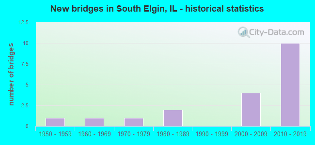
- New bridges - historical statistics
- 11950-1959
- 11960-1969
- 11970-1979
- 21980-1989
- 42000-2009
- 102010-2019
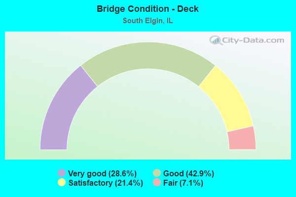
- Bridge Condition - Deck
- 28.6%Very good
- 42.9%Good
- 21.4%Satisfactory
- 7.1%Fair
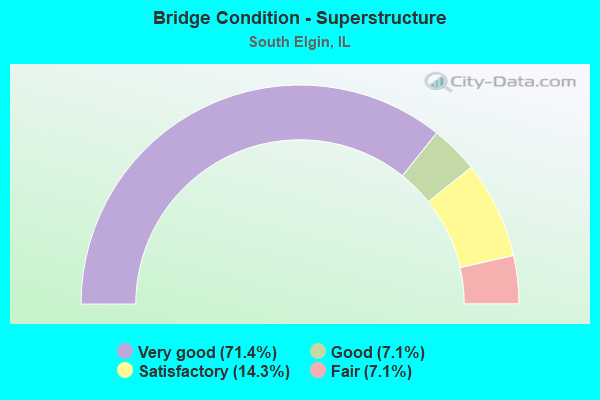
- Bridge Condition - Superstructure
- 71.4%Very good
- 7.1%Good
- 14.3%Satisfactory
- 7.1%Fair
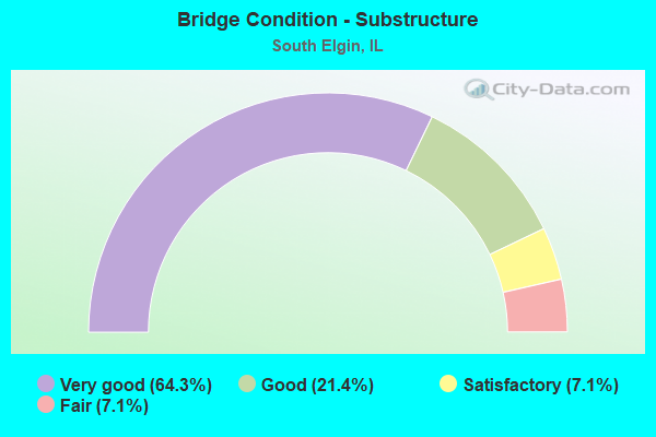
- Bridge Condition - Substructure
- 64.3%Very good
- 21.4%Good
- 7.1%Satisfactory
- 7.1%Fair
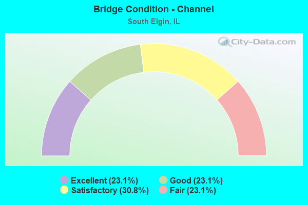
- Bridge Condition - Channel
- 23.1%Excellent
- 23.1%Good
- 30.8%Satisfactory
- 23.1%Fair
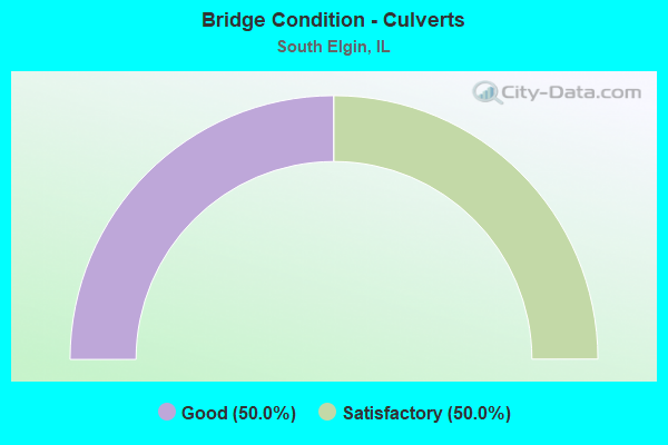
- Bridge Condition - Culverts
- 50.0%Good
- 50.0%Satisfactory
Find on map >> Show street view
Structure Number: 450018, Location: 3.2 M S OF US 20 (Lat: 41.979461, Lng: -88.297256), Route carried "on" structure: State highway 31, Year Built: 1955, Year Reconstructed: 1998, Status: Open, Structure Length: 5.02m (16.47ft), Average Daily Traffic: 6,100 (year 2021), Truck Traffic: 4%, Average Future Daily Traffic: 7,146 (year 2032), Design Load: HS 20, Features Intersected: RR - CN
Minimum Vertical Clearance: 30+ m (98+ ft), Kilometerpoint: 37.030, Lanes on structure: 2, Base Highway Network: Yes, Owner: State Highway Agency, Approaching Roadway Width: 12.2m (40.0ft), Material/Design: Steel continuous, Design/Construction: Stringer/Multi-beam, Number Of Spans In Main Unit: 3, Length of Maximum Span: 18.1m (59.4ft), Curb-To-Curb Width: 12.2m (40.0ft), Out-to-Out Width: 13.2m (43.3ft)
Condition: Deck: Good, Superstructure: Satisfactory, Substructure: Satisfactory, Operating Rating: 92.0 metric tons, Method Used To Determine Operating Rating: Load Factor (LF) rating reported by rating factor (RF) method using MS18 loading, Inventory Rating: 55.1 metric tons, Method Used To Determine Inventory Rating: Load Factor (LF) rating reported by rating factor (RF) method using MS18 loading, Structural Evaluation: Equal to present minimum criteria, Deck Geometry: Somewhat better than minimum adequacy, Underclear: Somewhat better than minimum adequacy, Approach Roadway Alignment: Equal to present desirable criteria, Length Of Structure Improvement: 6.04m (19.82ft), Designated Inspection Frequency: Every 24 months, Inspection Date: January 2022, Bridge Improvement Cost: $736,000, Roadway Improvement Cost: $74,000, Total Project Cost: $1,104,000, Deck Structure Type: Concrete Cast-file-Place, Wearing Surface/Protective System: Deck Protection: Epoxy Coated Reinforcing
Find on map >> Show street view
Structure Number: 452031, Location: 3.1 M S OF US 20 (Lat: 41.978125, Lng: -88.297489), Route carried "on" structure: State highway 31, Year Built: 2007, Status: Open, Structure Length: 5.14m (16.86ft), Average Daily Traffic: 6,100 (year 2021), Truck Traffic: 4%, Average Future Daily Traffic: 7,146 (year 2032), Design Load: HS 20, Features Intersected: STERNS RD
Minimum Vertical Clearance: 30+ m (98+ ft), Kilometerpoint: 36.805, Lanes on structure: 2, Lanes under structure: 4, Base Highway Network: Yes, Owner: State Highway Agency, Approaching Roadway Width: 12.2m (40.0ft), Material/Design: Prestressed concrete continuous, Design/Construction: Stringer/Multi-beam, Number Of Spans In Main Unit: 2, Length of Maximum Span: 26.8m (87.9ft), Curb-To-Curb Width: 13.0m (42.7ft), Out-to-Out Width: 14.1m (46.3ft)
Condition: Deck: Very good, Superstructure: Good, Substructure: Good, Operating Rating: 77.1 metric tons, Method Used To Determine Operating Rating: Load Factor (LF) rating reported by rating factor (RF) method using MS18 loading, Inventory Rating: 44.7 metric tons, Method Used To Determine Inventory Rating: Load Factor (LF) rating reported by rating factor (RF) method using MS18 loading, Structural Evaluation: Better than present minimum criteria, Deck Geometry: Somewhat better than minimum adequacy, Underclear: High priority of corrective action, Approach Roadway Alignment: Equal to present desirable criteria, Designated Inspection Frequency: Every 48 months, Inspection Date: Febuary 2018, Deck Structure Type: Concrete Cast-file-Place, Wearing Surface/Protective System: Deck Protection: Epoxy Coated Reinforcing
Find on map >> Show street view
Structure Number: 45302, Location: 0.8 MI W RANDALL RD (Lat: 41.955669, Lng: -88.357553), Route carried "on" structure: Other road , Year Built: 2011, Status: Open, Structure Length: 3.20m (10.50ft), Average Daily Traffic: 3,950 (year 2018), Truck Traffic: 8%, Average Future Daily Traffic: 4,594 (year 2032), Design Load: HS 25 or greater, Features Intersected: FERSON CREEK, Facility Carried by Structure: BOLCUM ROAD
Minimum Vertical Clearance: 30+ m (98+ ft), Kilometerpoint: 3.846, Lanes on structure: 2, Base Highway Network: Yes, Owner: Town or Township Highway Agency, Approaching Roadway Width: 9.4m (30.8ft), Material/Design: Steel continuous, Design/Construction: Stringer/Multi-beam, Number Of Spans In Main Unit: 2, Length of Maximum Span: 15.6m (51.2ft), Curb-To-Curb Width: 9.1m (29.9ft), Out-to-Out Width: 10.1m (33.1ft)
Condition: Deck: Satisfactory, Superstructure: Very good, Substructure: Very good, Channel: Fair, Operating Rating: 66.7 metric tons, Method Used To Determine Operating Rating: Load and Resistance Factor Rating (LRFR) rating reported by rating factor(RF) method using HL-93 loadings, Inventory Rating: 51.5 metric tons, Method Used To Determine Inventory Rating: Load and Resistance Factor Rating (LRFR) rating reported by rating factor(RF) method using HL-93 loadings, Structural Evaluation: Equal to present desirable criteria, Deck Geometry: Meets minimum limits, Waterway Adequacy: Equal to present desirable criteria, Approach Roadway Alignment: Equal to present minimum criteria, Designated Inspection Frequency: Every 48 months, Inspection Date: May 2021, Deck Structure Type: Concrete Cast-file-Place, Wearing Surface/Protective System: Deck Protection: Epoxy Coated Reinforcing
Find on map >> Show street view
Structure Number: 453054, Location: 0.3 m W of Randall (Lat: 41.985150, Lng: -88.355936), Route carried "on" structure: Other road , Year Built: 2017, Status: Open, Structure Length: 2.73m (8.96ft), Average Daily Traffic: 6,650 (year 2018), Truck Traffic: 6%, Average Future Daily Traffic: 14,000 (year 2040), Design Load: HS 25 or greater, Features Intersected: Otter Creek, Facility Carried by Structure: Mc Donald Road
Minimum Vertical Clearance: 30+ m (98+ ft), Kilometerpoint: 9.833, Lanes on structure: 2, Base Highway Network: Yes, Owner: City or Municipal Highway Agency, Approaching Roadway Width: 12.2m (40.0ft), Skew: 1 degrees, Material/Design: Prestressed concrete, Design/Construction: Stringer/Multi-beam, Number Of Spans In Main Unit: 1, Length of Maximum Span: 26.0m (85.3ft), Curb or Sidewalk Widths: Left: 1.5m (4.9ft), Right: 1.5m (4.9ft), Curb-To-Curb Width: 12.2m (40.0ft), Out-to-Out Width: 16.8m (55.1ft)
Condition: Deck: Very good, Superstructure: Very good, Substructure: Very good, Channel: Excellent, Operating Rating: 81.0 metric tons, Method Used To Determine Operating Rating: Load and Resistance Factor Rating (LRFR) rating reported by rating factor(RF) method using HL-93 loadings, Inventory Rating: 53.5 metric tons, Method Used To Determine Inventory Rating: Load and Resistance Factor Rating (LRFR) rating reported by rating factor(RF) method using HL-93 loadings, Structural Evaluation: Equal to present desirable criteria, Deck Geometry: Somewhat better than minimum adequacy, Waterway Adequacy: Superior to present desirable criteria, Approach Roadway Alignment: Equal to present desirable criteria, Designated Inspection Frequency: Every 48 months, Inspection Date: March 2019, Deck Structure Type: Concrete Cast-file-Place, Wearing Surface/Protective System: Deck Protection: Epoxy Coated Reinforcing
Find on map >> Show street view
Structure Number: 45306, Location: 1.07 MI W RANDALL RD (Lat: 41.970161, Lng: -88.361147), Route carried "on" structure: Other road , Year Built: 2011, Status: Open, Structure Length: 0.63m (2.07ft), Average Daily Traffic: 5,550 (year 2018), Truck Traffic: 4%, Average Future Daily Traffic: 4,083 (year 2032), Design Load: HS 20, Features Intersected: TRIB. TO OTTER CREEK, Facility Carried by Structure: SILVER GLEN RD
Minimum Vertical Clearance: 30+ m (98+ ft), Kilometerpoint: 10.139, Lanes on structure: 2, Owner: County Highway Agency, Approaching Roadway Width: 17.1m (56.1ft), Material/Design: Concrete continuous, Design/Construction: Culvert, Number Of Spans In Main Unit: 2, Length of Maximum Span: 3.3m (10.8ft), Curb-To-Curb Width: 17.1m (56.1ft)
Condition: Channel: Good, Culverts: Good, Operating Rating: 69.7 metric tons, Method Used To Determine Operating Rating: Load Factor (LF) rating reported by rating factor (RF) method using MS18 loading, Inventory Rating: 41.8 metric tons, Method Used To Determine Inventory Rating: Load Factor (LF) rating reported by rating factor (RF) method using MS18 loading, Structural Evaluation: Better than present minimum criteria, Deck Geometry: Superior to present desirable criteria, Waterway Adequacy: Equal to present desirable criteria, Approach Roadway Alignment: Equal to present desirable criteria, Designated Inspection Frequency: Every 48 months, Inspection Date: March 2018, Deck Structure Type: Concrete Cast-file-Place
Find on map >> Show street view
Structure Number: 45308, Location: 0.6M S of Silver Gle (Lat: 41.962386, Lng: -88.362250), Route carried "on" structure: County highway , Year Built: 2012, Status: Open, Structure Length: 1.77m (5.81ft), Average Daily Traffic: 3,850 (year 2018), Truck Traffic: 3%, Average Future Daily Traffic: 5,423 (year 2032), Design Load: HS 25 or greater, Features Intersected: FERSON CREEK, Facility Carried by Structure: BURR ROAD
Minimum Vertical Clearance: 30+ m (98+ ft), Kilometerpoint: 0.901, Lanes on structure: 2, Owner: Town or Township Highway Agency, Approaching Roadway Width: 7.3m (24.0ft), Material/Design: Steel, Design/Construction: Stringer/Multi-beam, Number Of Spans In Main Unit: 1, Length of Maximum Span: 16.9m (55.4ft), Curb-To-Curb Width: 9.8m (32.2ft), Out-to-Out Width: 9.8m (32.2ft)
Condition: Deck: Good, Superstructure: Very good, Substructure: Very good, Channel: Satisfactory, Operating Rating: 60.6 metric tons, Method Used To Determine Operating Rating: Load and Resistance Factor Rating (LRFR) rating reported by rating factor(RF) method using HL-93 loadings, Inventory Rating: 46.7 metric tons, Method Used To Determine Inventory Rating: Load and Resistance Factor Rating (LRFR) rating reported by rating factor(RF) method using HL-93 loadings, Structural Evaluation: Equal to present desirable criteria, Deck Geometry: Meets minimum limits, Waterway Adequacy: Superior to present desirable criteria, Approach Roadway Alignment: Equal to present desirable criteria, Designated Inspection Frequency: Every 48 months, Inspection Date: May 2021, Deck Structure Type: Concrete Cast-file-Place, Wearing Surface/Protective System: Deck Protection: Epoxy Coated Reinforcing
Find on map >> Show street view
Structure Number: 453093, Location: 1.0MI N MACDONALD RD (Lat: 41.990636, Lng: -88.364869), Route carried "on" structure: City street , Year Built: 1969, Status: Open, Structure Length: 1.13m (3.71ft), Average Daily Traffic: 3,400 (year 2018), Truck Traffic: 3%, Average Future Daily Traffic: 2,680 (year 2032), Design Load: HS 15, Features Intersected: STONEY CREEK, Facility Carried by Structure: STEVENS ROAD
Minimum Vertical Clearance: 30+ m (98+ ft), Kilometerpoint: 0.161, Lanes on structure: 2, Owner: City or Municipal Highway Agency, Approaching Roadway Width: 6.8m (22.3ft), Skew: 1 degrees, Material/Design: Concrete continuous, Design/Construction: Slab, Number Of Spans In Main Unit: 2, Length of Maximum Span: 5.8m (19.0ft), Curb-To-Curb Width: 10.9m (35.8ft), Out-to-Out Width: 11.5m (37.7ft)
Condition: Deck: Satisfactory, Superstructure: Satisfactory, Substructure: Good, Channel: Fair, Operating Rating: 41.8 metric tons, Method Used To Determine Operating Rating: Load Factor (LF) rating reported by rating factor (RF) method using MS18 loading, Inventory Rating: 25.3 metric tons, Method Used To Determine Inventory Rating: Load Factor (LF) rating reported by rating factor (RF) method using MS18 loading, Structural Evaluation: Equal to present minimum criteria, Deck Geometry: Somewhat better than minimum adequacy, Waterway Adequacy: Better than present minimum criteria, Approach Roadway Alignment: Equal to present desirable criteria, Designated Inspection Frequency: Every 24 months, Inspection Date: March 2021, Deck Structure Type: Concrete Cast-file-Place, Wearing Surface/Protective System: Wearing Surface: Bituminous
Find on map >> Show street view
Structure Number: 453128, Location: 300 FT E OF LAFOX ST (Lat: 41.994281, Lng: -88.294894), Route carried "on" structure: Other road , Year Built: 1988, Status: Open, Structure Length: 11.16m (36.61ft), Average Daily Traffic: 4,500 (year 2018), Truck Traffic: 7%, Average Future Daily Traffic: 2,616 (year 2032), Design Load: HS 20, Features Intersected: FOX RIVER, Facility Carried by Structure: STATE ST.
Minimum Vertical Clearance: 30+ m (98+ ft), Kilometerpoint: 0.177, Lanes on structure: 2, Base Highway Network: Yes, Owner: City or Municipal Highway Agency, Approaching Roadway Width: 9.1m (29.9ft), Material/Design: Prestressed concrete continuous, Design/Construction: Stringer/Multi-beam, Number Of Spans In Main Unit: 5, Length of Maximum Span: 22.3m (73.2ft), Curb or Sidewalk Widths: Left: 1.5m (4.9ft), Right: 3.1m (10.2ft), Curb-To-Curb Width: 9.1m (29.9ft), Out-to-Out Width: 15.6m (51.2ft)
Condition: Deck: Good, Superstructure: Very good, Substructure: Very good, Channel: Excellent, Operating Rating: 44.4 metric tons, Method Used To Determine Operating Rating: Assigned rating based on Load Factor Design (LFD) reported by rating factor (RF) using MS18 loading, Inventory Rating: 32.4 metric tons, Method Used To Determine Inventory Rating: Assigned rating based on Load Factor Design (LFD) reported by rating factor (RF) using MS18 loading, Structural Evaluation: Equal to present desirable criteria, Deck Geometry: Meets minimum limits, Waterway Adequacy: Superior to present desirable criteria, Approach Roadway Alignment: Equal to present desirable criteria, Designated Inspection Frequency: Every 48 months, Inspection Date: March 2019, Deck Structure Type: Concrete Cast-file-Place
Find on map >> Show street view
Structure Number: 45313, Location: 0.3 MI S BY PASS 20 (Lat: 42.013881, Lng: -88.274072), Route carried "on" structure: Other road , Year Built: 1986, Status: Open, Structure Length: 2.43m (7.97ft), Average Daily Traffic: 2,900 (year 2018), Truck Traffic: 5%, Average Future Daily Traffic: 5,423 (year 2032), Design Load: HS 20, Features Intersected: POPLAR CREEK, Facility Carried by Structure: RAYMOND STREET
Minimum Vertical Clearance: 30+ m (98+ ft), Kilometerpoint: 3.701, Lanes on structure: 2, Owner: Town or Township Highway Agency, Approaching Roadway Width: 7.3m (24.0ft), Skew: 2 degrees, Material/Design: Prestressed concrete, Design/Construction: Box Beam or Girders - Multiple, Number Of Spans In Main Unit: 3, Length of Maximum Span: 8.7m (28.5ft), Curb-To-Curb Width: 11.1m (36.4ft), Out-to-Out Width: 11.9m (39.0ft)
Condition: Deck: Fair, Superstructure: Fair, Substructure: Fair, Channel: Satisfactory, Operating Rating: 51.5 metric tons, Method Used To Determine Operating Rating: Load Factor (LF) rating reported by rating factor (RF) method using MS18 loading, Inventory Rating: 30.8 metric tons, Method Used To Determine Inventory Rating: Load Factor (LF) rating reported by rating factor (RF) method using MS18 loading, Structural Evaluation: Somewhat better than minimum adequacy, Deck Geometry: Somewhat better than minimum adequacy, Waterway Adequacy: Better than present minimum criteria, Approach Roadway Alignment: Equal to present desirable criteria, Designated Inspection Frequency: Every 24 months, Inspection Date: May 2021, Deck Structure Type: Concrete Precast Panels, Wearing Surface/Protective System: Wearing Surface: Bituminous, Membrane: Built-up
Find on map >> Show street view
Structure Number: 453161, Location: 0.8 MI W RANDALL RD (Lat: 41.970219, Lng: -88.356339), Route carried "on" structure: Other road , Year Built: 2019, Status: Open, Structure Length: 3.46m (11.35ft), Average Daily Traffic: 8,450 (year 2018), Truck Traffic: 8%, Average Future Daily Traffic: 12,760 (year 2038), Design Load: HS 25 or greater, Features Intersected: OTTER CREEK, Facility Carried by Structure: SILVER GLEN ROAD
Minimum Vertical Clearance: 30+ m (98+ ft), Kilometerpoint: 10.525, Lanes on structure: 2, Owner: County Highway Agency, Approaching Roadway Width: 12.2m (40.0ft), Material/Design: Concrete continuous, Design/Construction: Slab, Number Of Spans In Main Unit: 3, Length of Maximum Span: 12.2m (40.0ft), Curb-To-Curb Width: 12.2m (40.0ft), Out-to-Out Width: 13.0m (42.7ft)
Condition: Deck: Very good, Superstructure: Very good, Substructure: Very good, Channel: Satisfactory, Operating Rating: 46.7 metric tons, Method Used To Determine Operating Rating: Load and Resistance Factor Rating (LRFR) rating reported by rating factor(RF) method using HL-93 loadings, Inventory Rating: 36.0 metric tons, Method Used To Determine Inventory Rating: Load and Resistance Factor Rating (LRFR) rating reported by rating factor(RF) method using HL-93 loadings, Structural Evaluation: Equal to present desirable criteria, Deck Geometry: Somewhat better than minimum adequacy, Waterway Adequacy: Superior to present desirable criteria, Approach Roadway Alignment: Equal to present desirable criteria, Designated Inspection Frequency: Every 48 months, Inspection Date: May 2021, Deck Structure Type: Concrete Cast-file-Place, Wearing Surface/Protective System: Wearing Surface: Other, Deck Protection: Epoxy Coated Reinforcing
Find on map >> Show street view
Structure Number: 453162, Location: 2 Mi. west of Ill 31 (Lat: 41.985094, Lng: -88.331256), Route carried "on" structure: County highway , Year Built: 2012, Status: Open, Structure Length: 2.36m (7.74ft), Average Daily Traffic: 12,200 (year 2018), Truck Traffic: 7%, Average Future Daily Traffic: 5,650 (year 2032), Design Load: HS 25 or greater, Features Intersected: CNIC RR(CC&P), Facility Carried by Structure: UMBDENSTOCK RD
Minimum Vertical Clearance: 30+ m (98+ ft), Kilometerpoint: 0.740, Lanes on structure: 2, Owner: City or Municipal Highway Agency, Approaching Roadway Width: 11.0m (36.1ft), Skew: 2 degrees, Material/Design: Prestressed concrete, Design/Construction: Stringer/Multi-beam, Number Of Spans In Main Unit: 1, Length of Maximum Span: 21.3m (69.9ft), Curb-To-Curb Width: 12.2m (40.0ft), Out-to-Out Width: 14.6m (47.9ft)
Condition: Deck: Very good, Superstructure: Very good, Substructure: Very good, Operating Rating: 44.1 metric tons, Method Used To Determine Operating Rating: Assigned rating based on Load Factor Design (LFD) reported by rating factor (RF) using MS18 loading, Inventory Rating: 32.4 metric tons, Method Used To Determine Inventory Rating: Assigned rating based on Load Factor Design (LFD) reported by rating factor (RF) using MS18 loading, Structural Evaluation: Equal to present desirable criteria, Deck Geometry: Somewhat better than minimum adequacy, Underclear: Equal to present desirable criteria, Approach Roadway Alignment: Better than present minimum criteria, Designated Inspection Frequency: Every 48 months, Inspection Date: October 2018, Deck Structure Type: Concrete Cast-file-Place, Wearing Surface/Protective System: Deck Protection: Epoxy Coated Reinforcing
Find on map >> Show street view
Structure Number: 453165, Location: 0.3 MI W OF IL 25 (Lat: 41.977100, Lng: -88.286281), Route carried "on" structure: Other road , Year Built: 2010, Status: Open, Structure Length: 3.22m (10.56ft), Average Daily Traffic: 13,400 (year 2018), Truck Traffic: 9%, Average Future Daily Traffic: 638 (year 2032), Design Load: HS 20, Features Intersected: N ARM BREWSTER CRK, Facility Carried by Structure: STEARNS RD WB
Minimum Vertical Clearance: 30+ m (98+ ft), Kilometerpoint: 4.184, Lanes on structure: 2, Base Highway Network: Yes, Owner: County Highway Agency, Approaching Roadway Width: 8.5m (27.9ft), Skew: 2 degrees, Material/Design: Steel, Design/Construction: Stringer/Multi-beam, Number Of Spans In Main Unit: 1, Length of Maximum Span: 31.4m (103.0ft), Curb or Sidewalk Widths: Left: 3.7m (12.1ft), Right: 0.0m, Curb-To-Curb Width: 8.5m (27.9ft), Out-to-Out Width: 13.4m (44.0ft)
Condition: Deck: Good, Superstructure: Very good, Substructure: Very good, Channel: Good, Operating Rating: 88.8 metric tons, Method Used To Determine Operating Rating: Load Factor (LF) rating reported by rating factor (RF) method using MS18 loading, Inventory Rating: 51.8 metric tons, Method Used To Determine Inventory Rating: Load Factor (LF) rating reported by rating factor (RF) method using MS18 loading, Structural Evaluation: Equal to present desirable criteria, Deck Geometry: High priority of corrective action, Waterway Adequacy: Equal to present desirable criteria, Approach Roadway Alignment: Equal to present desirable criteria, Designated Inspection Frequency: Every 24 months, Inspection Date: March 2020, Deck Structure Type: Concrete Cast-file-Place, Wearing Surface/Protective System: Deck Protection: Epoxy Coated Reinforcing
Find on map >> Show street view
Structure Number: 453166, Location: 0.6 MI W OF IL25 (Lat: 41.977706, Lng: -88.294211), Route carried "on" structure: Other road , Year Built: 2010, Status: Open, Structure Length: 29.88m (98.03ft), Average Daily Traffic: 13,400 (year 2018), Truck Traffic: 9%, Average Future Daily Traffic: 638 (year 2032), Design Load: HS 25 or greater, Features Intersected: FOX RIVER, Facility Carried by Structure: STEARNS RD
Minimum Vertical Clearance: 30+ m (98+ ft), Kilometerpoint: 3.492, Lanes on structure: 4, Base Highway Network: Yes, Owner: County Highway Agency, Approaching Roadway Width: 17.1m (56.1ft), Skew: 30 degrees, Material/Design: Steel continuous, Design/Construction: Stringer/Multi-beam, Number Of Spans In Main Unit: 5, Length of Maximum Span: 64.0m (210.0ft), Curb-To-Curb Width: 17.1m (56.1ft), Out-to-Out Width: 19.2m (63.0ft)
Condition: Deck: Satisfactory, Superstructure: Very good, Substructure: Very good, Channel: Excellent, Operating Rating: 52.2 metric tons, Method Used To Determine Operating Rating: Load and Resistance Factor Rating (LRFR) rating reported by rating factor(RF) method using HL-93 loadings, Inventory Rating: 40.2 metric tons, Method Used To Determine Inventory Rating: Load and Resistance Factor Rating (LRFR) rating reported by rating factor(RF) method using HL-93 loadings, Structural Evaluation: Equal to present desirable criteria, Deck Geometry: Somewhat better than minimum adequacy, Waterway Adequacy: Superior to present desirable criteria, Approach Roadway Alignment: Equal to present desirable criteria, Designated Inspection Frequency: Every 24 months, Inspection Date: May 2020, Deck Structure Type: Concrete Cast-file-Place, Wearing Surface/Protective System: Deck Protection: Epoxy Coated Reinforcing
Find on map >> Show street view
Structure Number: 453167, Location: 0.3 MI W OF IL 25 (Lat: 41.977311, Lng: -88.287164), Route carried "on" structure: Other road , Year Built: 2010, Status: Open, Structure Length: 5.64m (18.50ft), Average Daily Traffic: 13,400 (year 2018), Truck Traffic: 9%, Average Future Daily Traffic: 638 (year 2032), Design Load: HS 20, Features Intersected: N ARM BREWSTER CRK, Facility Carried by Structure: STEARNS RD EB
Minimum Vertical Clearance: 30+ m (98+ ft), Kilometerpoint: 4.104, Lanes on structure: 2, Base Highway Network: Yes, Owner: County Highway Agency, Approaching Roadway Width: 8.9m (29.2ft), Skew: 3 degrees, Material/Design: Steel continuous, Design/Construction: Stringer/Multi-beam, Number Of Spans In Main Unit: 2, Length of Maximum Span: 31.9m (104.7ft), Curb-To-Curb Width: 8.9m (29.2ft), Out-to-Out Width: 9.9m (32.5ft)
Condition: Deck: Good, Superstructure: Very good, Substructure: Good, Channel: Good, Operating Rating: 88.8 metric tons, Method Used To Determine Operating Rating: Load Factor (LF) rating reported by rating factor (RF) method using MS18 loading, Inventory Rating: 62.9 metric tons, Method Used To Determine Inventory Rating: Load Factor (LF) rating reported by rating factor (RF) method using MS18 loading, Structural Evaluation: Better than present minimum criteria, Deck Geometry: High priority of corrective action, Waterway Adequacy: Equal to present desirable criteria, Approach Roadway Alignment: Equal to present desirable criteria, Designated Inspection Frequency: Every 24 months, Inspection Date: March 2020, Deck Structure Type: Concrete Cast-file-Place, Wearing Surface/Protective System: Deck Protection: Epoxy Coated Reinforcing
Find on map >> Show street view
Structure Number: 45318, Location: 1 MI W RANDALL ROAD (Lat: 41.995578, Lng: -88.356814), Route carried "on" structure: County highway , Year Built: 2012, Status: Open, Structure Length: 2.01m (6.59ft), Average Daily Traffic: 3,250 (year 2018), Truck Traffic: 5%, Average Future Daily Traffic: 3,600 (year 2032), Design Load: HS 25 or greater, Features Intersected: OTTER CREEK, Facility Carried by Structure: HOPPS ROAD
Minimum Vertical Clearance: 30+ m (98+ ft), Kilometerpoint: 1.110, Lanes on structure: 2, Owner: Town or Township Highway Agency, Approaching Roadway Width: 9.8m (32.2ft), Material/Design: Prestressed concrete, Design/Construction: Box Beam or Girders - Multiple, Number Of Spans In Main Unit: 2, Length of Maximum Span: 11.9m (39.0ft), Curb-To-Curb Width: 9.8m (32.2ft), Out-to-Out Width: 9.8m (32.2ft)
Condition: Deck: Good, Superstructure: Very good, Substructure: Very good, Channel: Satisfactory, Operating Rating: 53.8 metric tons, Method Used To Determine Operating Rating: Load and Resistance Factor Rating (LRFR) rating reported by rating factor(RF) method using HL-93 loadings, Inventory Rating: 41.8 metric tons, Method Used To Determine Inventory Rating: Load and Resistance Factor Rating (LRFR) rating reported by rating factor(RF) method using HL-93 loadings, Structural Evaluation: Equal to present desirable criteria, Deck Geometry: Meets minimum limits, Waterway Adequacy: Equal to present desirable criteria, Approach Roadway Alignment: Equal to present desirable criteria, Designated Inspection Frequency: Every 48 months, Inspection Date: May 2021, Deck Structure Type: Concrete Precast Panels, Wearing Surface/Protective System: Wearing Surface: Integral Concrete, Deck Protection: Epoxy Coated Reinforcing
Find on map >> Show street view
Structure Number: 455004, Location: 0.2 M N SILVER GLEN (Lat: 41.974147, Lng: -88.363869), Route carried "on" structure: County highway , Year Built: 1972, Status: Open, Structure Length: 0.70m (2.30ft), Average Daily Traffic: 3,400 (year 2018), Truck Traffic: 2%, Average Future Daily Traffic: 3,318 (year 2032), Design Load: HS 20, Features Intersected: W. TRIB. OF OTTER CR, Facility Carried by Structure: STEVENS RD
Minimum Vertical Clearance: 30+ m (98+ ft), Kilometerpoint: 1.625, Lanes on structure: 2, Owner: Town or Township Highway Agency, Approaching Roadway Width: 7.9m (25.9ft), Skew: 5 degrees, Material/Design: Concrete, Design/Construction: Culvert, Number Of Spans In Main Unit: 1, Length of Maximum Span: 7.0m (23.0ft), Curb-To-Curb Width: 9.8m (32.2ft), Out-to-Out Width: 10.4m (34.1ft)
Condition: Channel: Fair, Culverts: Satisfactory, Operating Rating: 59.0 metric tons, Method Used To Determine Operating Rating: Load Factor (LF) rating reported by rating factor (RF) method using MS18 loading, Inventory Rating: 35.3 metric tons, Method Used To Determine Inventory Rating: Load Factor (LF) rating reported by rating factor (RF) method using MS18 loading, Structural Evaluation: Equal to present minimum criteria, Deck Geometry: Meets minimum limits, Waterway Adequacy: Equal to present minimum criteria, Approach Roadway Alignment: Equal to present desirable criteria, Designated Inspection Frequency: Every 24 months, Inspection Date: April 2021
Find on map >> Show street view
Structure Number: 452031, Location: 3.1 M S OF US 20 (Lat: 41.977803, Lng: -88.296625), Route carried "under" structure: Other road , Year Built: 2007, Structure Length: 0. m, Average Daily Traffic: 13,400 (year 2018), Truck Traffic: 9%, Features Intersected: STERNS RD, Facility Carried by Structure: IL 31
Minimum Vertical Clearance: 4.52m (14.83ft), Kilometerpoint: 3.283, Lanes on structure: 2, Lanes under structure: 4, Material/Design: Prestressed concrete continuous, Design/Construction: Stringer/Multi-beam, Length of Maximum Span: 26.8m (87.9ft)
Find on map >> Show street view
Structure Number: 453163, Location: 0.25 Mi N. of IL 31 (Lat: 41.979286, Lng: -88.316411), Route carried "under" structure: Other road , Year Built: 2009, Structure Length: 0. m, Average Daily Traffic: 7,700 (year 2021), Truck Traffic: 3%, Features Intersected: MCLEAN BLVD, Facility Carried by Structure: CNIC RR(CC&P)
Minimum Vertical Clearance: 4.27m (14.01ft), Kilometerpoint: 14.097, Lanes under structure: 2, Length of Maximum Span: 35.1m (115.2ft)
Find on map >> Show street view
Structure Number: 459, Location: 90FT N SILVER GLENN (Lat: 41.970014, Lng: -88.340614), Route carried "under" structure: Other road , Year Built: 2009, Structure Length: 0. m, Average Daily Traffic: 32,100 (year 2018), Truck Traffic: 6%, Features Intersected: RANDALL ROAD, Facility Carried by Structure: RANDALL RD BIKE PA
Minimum Vertical Clearance: 30.40m (99.74ft), Kilometerpoint: 20.583, Lanes under structure: 4, Material/Design: Steel, Design/Construction: Box Beam or Girders - Single/Spread, Length of Maximum Span: 0.0m