Bridge Statistics for South Milwaukee, Wisconsin (WI)
Condition, Traffic, Stress, Structural Evaluation, Project Costs
- National Bridge Inventory (NBI) Statistics
- 12Number of bridges
- 56ft / 16.8mTotal length
- 58,893Total average daily traffic
- 347Total average daily truck traffic
- National Bridge Inventory (NBI) Registered Bridges for South Milwaukee
- No street view available for this location
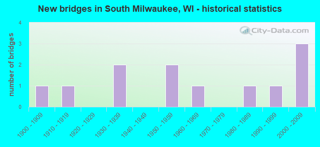
- New bridges - historical statistics
- 11900-1909
- 11910-1919
- 21930-1939
- 21950-1959
- 11960-1969
- 11980-1989
- 11990-1999
- 32000-2009

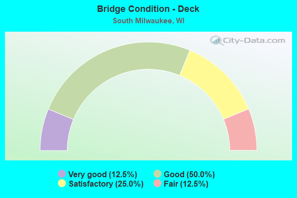
- Bridge Condition - Deck
- 12.5%Very good
- 50.0%Good
- 25.0%Satisfactory
- 12.5%Fair
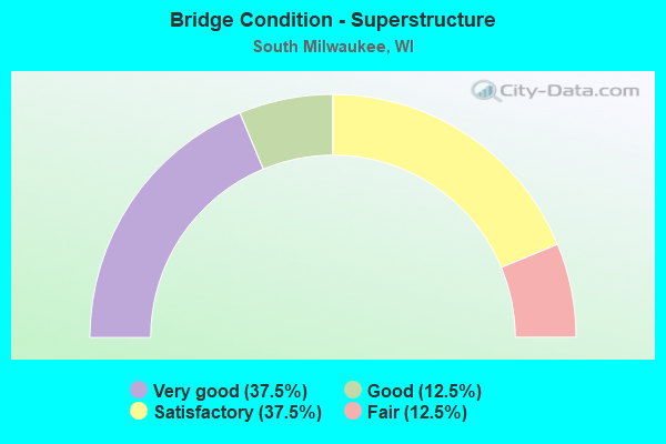
- Bridge Condition - Superstructure
- 37.5%Very good
- 12.5%Good
- 37.5%Satisfactory
- 12.5%Fair
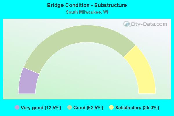
- Bridge Condition - Substructure
- 12.5%Very good
- 62.5%Good
- 25.0%Satisfactory
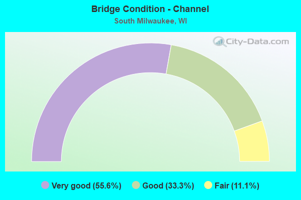
- Bridge Condition - Channel
- 55.6%Very good
- 33.3%Good
- 11.1%Fair
Find on map >> Show street view
Structure Number: B400026, Location: 0.1M E JCT STH 32 (CHIC A (Lat: 42.915178, Lng: -87.857350), Route carried "on" structure: City street , Year Built: 1999, Status: Open, Structure Length: 1.58m (5.18ft), Average Daily Traffic: 2,073 (year 2019), Average Future Daily Traffic: 2,280 (year 2039), Design Load: HS 20, Features Intersected: OAK CREEK, Facility Carried by Structure: LRD OAK CREEK PARK
Minimum Vertical Clearance: 30+ m (98+ ft), Kilometerpoint: 0.000, Lanes on structure: 2, Owner: County Highway Agency, Approaching Roadway Width: 9.1m (29.9ft), Skew: 1 degrees, Material/Design: Prestressed concrete, Design/Construction: Stringer/Multi-beam, Number Of Spans In Main Unit: 1, Length of Maximum Span: 15.0m (49.2ft), Curb or Sidewalk Widths: Left: 1.8m (5.9ft), Right: 1.8m (5.9ft), Curb-To-Curb Width: 9.0m (29.5ft), Out-to-Out Width: 13.8m (45.3ft)
Condition: Deck: Good, Superstructure: Very good, Substructure: Good, Channel: Very good, Operating Rating: 65.0 metric tons, Method Used To Determine Operating Rating: Load Factor (LF), Inventory Rating: 38.9 metric tons, Method Used To Determine Inventory Rating: Load Factor (LF), Structural Evaluation: Better than present minimum criteria, Deck Geometry: Meets minimum limits, Waterway Adequacy: Equal to present desirable criteria, Approach Roadway Alignment: Equal to present desirable criteria, Designated Inspection Frequency: Every 48 months, Inspection Date: June 2020, Deck Structure Type: Concrete Cast-file-Place, Wearing Surface/Protective System: Wearing Surface: Bituminous, Deck Protection: Epoxy Coated Reinforcing
Find on map >> Show street view
Structure Number: B400218, Location: 1.0M S JCT STH 32 (Lat: 42.907958, Lng: -87.846889), Route carried "on" structure: City street , Year Built: 2002, Status: Open, Structure Length: 2.19m (7.19ft), Average Daily Traffic: 3,807 (year 2019), Truck Traffic: 1%, Average Future Daily Traffic: 4,187 (year 2039), Design Load: HS 20, Features Intersected: OAK CREEK, Facility Carried by Structure: LRD OAK CREEK PARK
Minimum Vertical Clearance: 30+ m (98+ ft), Kilometerpoint: 0.000, Lanes on structure: 2, Owner: County Highway Agency, Approaching Roadway Width: 9.1m (29.9ft), Skew: 2 degrees, Material/Design: Prestressed concrete, Design/Construction: Stringer/Multi-beam, Number Of Spans In Main Unit: 1, Length of Maximum Span: 20.7m (67.9ft), Curb or Sidewalk Widths: Left: 1.8m (5.9ft), Right: 2.0m (6.6ft), Curb-To-Curb Width: 9.1m (29.9ft), Out-to-Out Width: 14.0m (45.9ft)
Condition: Deck: Good, Superstructure: Good, Substructure: Good, Channel: Very good, Operating Rating: 67.0 metric tons, Method Used To Determine Operating Rating: Load Factor (LF), Inventory Rating: 34.0 metric tons, Method Used To Determine Inventory Rating: Load Factor (LF), Structural Evaluation: Better than present minimum criteria, Deck Geometry: Meets minimum limits, Waterway Adequacy: Equal to present desirable criteria, Approach Roadway Alignment: Equal to present minimum criteria, Designated Inspection Frequency: Every 48 months, Inspection Date: June 2020, Deck Structure Type: Concrete Cast-file-Place, Wearing Surface/Protective System: Wearing Surface: Bituminous, Deck Protection: Epoxy Coated Reinforcing
Find on map >> Show street view
Structure Number: B400557, Location: 0.6M W JCT STH 32 (Lat: 42.915361, Lng: -87.873417), Route carried "on" structure: County highway , Year Built: 1986, Status: Open, Structure Length: 1.17m (3.84ft), Average Daily Traffic: 7,900 (year 2018), Average Future Daily Traffic: 9,232 (year 2039), Design Load: HS 20, Features Intersected: OAK CREEK, Facility Carried by Structure: CTH BB &RAWSON AVE
Minimum Vertical Clearance: 30+ m (98+ ft), Kilometerpoint: 0.000, Lanes on structure: 2, Base Highway Network: Yes, Owner: City or Municipal Highway Agency, Approaching Roadway Width: 25.6m (84.0ft), Skew: 6 degrees, Material/Design: Concrete, Design/Construction: Culvert, Number Of Spans In Main Unit: 3, Length of Maximum Span: 2.6m (8.5ft)
Condition: Channel: Good, Culverts: Satisfactory, Operating Rating: 53.9 metric tons, Method Used To Determine Operating Rating: Field evaluation and documented engineering judgment, Inventory Rating: 32.4 metric tons, Method Used To Determine Inventory Rating: Field evaluation and documented engineering judgment, Structural Evaluation: Equal to present minimum criteria, Waterway Adequacy: Equal to present desirable criteria, Approach Roadway Alignment: Equal to present desirable criteria, Designated Inspection Frequency: Every 24 months, Inspection Date: July 2020, Deck Structure Type: Concrete Cast-file-Place, Wearing Surface/Protective System: Wearing Surface: Monolithic Concrete
Find on map >> Show street view
Structure Number: B400672, Location: 0.3M S JCT COLLEGE (CTH Z (Lat: 42.924664, Lng: -87.870764), Route carried "on" structure: City street , Year Built: 2002, Status: Open, Structure Length: 1.70m (5.58ft), Average Daily Traffic: 5,431 (year 2019), Truck Traffic: 1%, Average Future Daily Traffic: 5,974 (year 2039), Design Load: HS 20, Features Intersected: OAK CREEK, Facility Carried by Structure: LRD 15TH AVE
Minimum Vertical Clearance: 30+ m (98+ ft), Kilometerpoint: 0.000, Lanes on structure: 2, Owner: City or Municipal Highway Agency, Approaching Roadway Width: 12.2m (40.0ft), Material/Design: Prestressed concrete, Design/Construction: Stringer/Multi-beam, Number Of Spans In Main Unit: 1, Length of Maximum Span: 15.8m (51.8ft), Curb or Sidewalk Widths: Left: 3.0m (9.8ft), Right: 3.0m (9.8ft), Curb-To-Curb Width: 12.2m (40.0ft), Out-to-Out Width: 18.3m (60.0ft)
Condition: Deck: Good, Superstructure: Very good, Substructure: Good, Channel: Very good, Operating Rating: 62.1 metric tons, Method Used To Determine Operating Rating: Load Factor (LF), Inventory Rating: 38.9 metric tons, Method Used To Determine Inventory Rating: Load Factor (LF), Structural Evaluation: Better than present minimum criteria, Deck Geometry: Somewhat better than minimum adequacy, Waterway Adequacy: Superior to present desirable criteria, Approach Roadway Alignment: Equal to present desirable criteria, Designated Inspection Frequency: Every 24 months, Inspection Date: July 2020, Deck Structure Type: Concrete Cast-file-Place, Wearing Surface/Protective System: Wearing Surface: Monolithic Concrete, Deck Protection: Epoxy Coated Reinforcing
Find on map >> Show street view
Structure Number: B400714, Location: CITY OF MILWAUKEE (Lat: 42.914283, Lng: -87.856139), Route carried "on" structure: City street , Year Built: 2007, Status: Open, Structure Length: 2.83m (9.28ft), Average Daily Traffic: 2,132 (year 2019), Truck Traffic: 1%, Average Future Daily Traffic: 2,345 (year 2039), Design Load: HS 20, Features Intersected: OAK CREEK, Facility Carried by Structure: LRD OAK CREEK PARK
Minimum Vertical Clearance: 30+ m (98+ ft), Kilometerpoint: 0.000, Lanes on structure: 2, Owner: County Highway Agency, Approaching Roadway Width: 9.1m (29.9ft), Material/Design: Concrete, Design/Construction: Slab, Number Of Spans In Main Unit: 2, Length of Maximum Span: 13.7m (44.9ft), Curb or Sidewalk Widths: Left: 2.0m (6.6ft), Right: 2.0m (6.6ft), Curb-To-Curb Width: 9.1m (29.9ft), Out-to-Out Width: 13.7m (44.9ft)
Condition: Deck: Very good, Superstructure: Very good, Substructure: Very good, Channel: Fair, Operating Rating: 68.6 metric tons, Method Used To Determine Operating Rating: Load Factor (LF), Inventory Rating: 40.5 metric tons, Method Used To Determine Inventory Rating: Load Factor (LF), Structural Evaluation: Equal to present desirable criteria, Deck Geometry: Meets minimum limits, Waterway Adequacy: Equal to present desirable criteria, Approach Roadway Alignment: Equal to present minimum criteria, Designated Inspection Frequency: Every 24 months, Inspection Date: June 2020, Deck Structure Type: Concrete Cast-file-Place, Wearing Surface/Protective System: Wearing Surface: Bituminous, Deck Protection: Epoxy Coated Reinforcing
Find on map >> Show street view
Structure Number: P400504, Location: 1.3M S JCT COLLEGE CTH ZZ (Lat: 42.910233, Lng: -87.871508), Route carried "on" structure: City street , Year Built: 1957, Status: Open, Structure Length: 1.55m (5.09ft), Average Daily Traffic: 7,739 (year 2019), Average Future Daily Traffic: 8,512 (year 2039), Design Load: H 20, Features Intersected: OAK CREEK, Facility Carried by Structure: LRD S 15TH AVE.
Minimum Vertical Clearance: 30+ m (98+ ft), Kilometerpoint: 0.000, Lanes on structure: 2, Owner: City or Municipal Highway Agency, Approaching Roadway Width: 12.2m (40.0ft), Skew: 3 degrees, Material/Design: Concrete, Design/Construction: Stringer/Multi-beam, Number Of Spans In Main Unit: 1, Length of Maximum Span: 15.5m (50.9ft), Curb or Sidewalk Widths: Left: 2.6m (8.5ft), Right: 2.6m (8.5ft), Curb-To-Curb Width: 12.2m (40.0ft), Out-to-Out Width: 17.4m (57.1ft)
Condition: Deck: Satisfactory, Superstructure: Satisfactory, Substructure: Good, Channel: Good, Operating Rating: 73.0 metric tons, Method Used To Determine Operating Rating: Load Factor (LF), Inventory Rating: 42.1 metric tons, Method Used To Determine Inventory Rating: Load Factor (LF), Structural Evaluation: Equal to present minimum criteria, Deck Geometry: Somewhat better than minimum adequacy, Waterway Adequacy: Better than present minimum criteria, Approach Roadway Alignment: Equal to present desirable criteria, Designated Inspection Frequency: Every 24 months, Inspection Date: July 2020, Deck Structure Type: Concrete Cast-file-Place, Wearing Surface/Protective System: Wearing Surface: Low Slump Concrete
Find on map >> Show street view
Structure Number: P400735, Location: 0.5M W JCT STH 32 (Lat: 42.910806, Lng: -87.871219), Route carried "on" structure: City street , Year Built: 1960, Status: Posted for load, Structure Length: 3.35m (10.99ft), Average Daily Traffic: 6,322 (year 2019), Average Future Daily Traffic: 6,954 (year 2040), Design Load: H 15, Features Intersected: OAK CREEK, Facility Carried by Structure: LRD MILWAUKEE AVE
Minimum Vertical Clearance: 30+ m (98+ ft), Kilometerpoint: 0.000, Lanes on structure: 2, Owner: City or Municipal Highway Agency, Approaching Roadway Width: 15.2m (49.9ft), Material/Design: Concrete, Design/Construction: Frame, Number Of Spans In Main Unit: 1, Length of Maximum Span: 12.9m (42.3ft), Curb or Sidewalk Widths: Left: 2.6m (8.5ft), Right: 2.6m (8.5ft), Curb-To-Curb Width: 15.2m (49.9ft), Out-to-Out Width: 20.4m (66.9ft)
Condition: Deck: Fair, Superstructure: Satisfactory, Substructure: Satisfactory, Channel: Very good, Operating Rating: 41.0 metric tons, Method Used To Determine Operating Rating: Field evaluation and documented engineering judgment, Inventory Rating: 24.3 metric tons, Method Used To Determine Inventory Rating: Field evaluation and documented engineering judgment, Structural Evaluation: Equal to present minimum criteria, Deck Geometry: Superior to present desirable criteria, Waterway Adequacy: Equal to present desirable criteria, Approach Roadway Alignment: Equal to present desirable criteria, Bridge Posting: Required (Relationship of Operating Rating to Maximum Legal Load: 10.0 - 19.9% below), Designated Inspection Frequency: Every 12 months, Inspection Date: September 2021, Deck Structure Type: Concrete Cast-file-Place, Wearing Surface/Protective System: Wearing Surface: Low Slump Concrete, Membrane: Other
Find on map >> Show street view
Structure Number: P400738, Location: 1.1M S JCT COLLEGE (CTH (Lat: 42.914022, Lng: -87.871411), Route carried "on" structure: City street , Year Built: 1957, Status: Open, Structure Length: 1.48m (4.86ft), Average Daily Traffic: 6,127 (year 2019), Average Future Daily Traffic: 6,739 (year 2039), Design Load: H 20, Features Intersected: OAK CREEK, Facility Carried by Structure: LRD 15TH AVE
Minimum Vertical Clearance: 30+ m (98+ ft), Kilometerpoint: 0.000, Lanes on structure: 2, Owner: City or Municipal Highway Agency, Approaching Roadway Width: 11.9m (39.0ft), Skew: 3 degrees, Material/Design: Concrete, Design/Construction: Stringer/Multi-beam, Number Of Spans In Main Unit: 1, Length of Maximum Span: 14.6m (47.9ft), Curb or Sidewalk Widths: Left: 2.6m (8.5ft), Right: 2.6m (8.5ft), Curb-To-Curb Width: 11.9m (39.0ft), Out-to-Out Width: 17.1m (56.1ft)
Condition: Deck: Good, Superstructure: Fair, Substructure: Good, Channel: Good, Operating Rating: 53.9 metric tons, Method Used To Determine Operating Rating: Load Factor (LF), Inventory Rating: 29.2 metric tons, Method Used To Determine Inventory Rating: Load Factor (LF), Structural Evaluation: Somewhat better than minimum adequacy, Deck Geometry: Somewhat better than minimum adequacy, Waterway Adequacy: Equal to present desirable criteria, Approach Roadway Alignment: Equal to present desirable criteria, Designated Inspection Frequency: Every 24 months, Inspection Date: July 2020, Deck Structure Type: Concrete Cast-file-Place, Wearing Surface/Protective System: Wearing Surface: Low Slump Concrete
Find on map >> Show street view
Structure Number: P40074, Location: 0.5M S JCT STH 32 (Lat: 42.912272, Lng: -87.852164), Route carried "on" structure: City street , Year Built: 1931, Status: Open, Structure Length: 0.91m (2.99ft), Average Daily Traffic: 1,762 (year 2019), Average Future Daily Traffic: 1,938 (year 2039), Design Load: H 15, Features Intersected: OAK CREEK, Facility Carried by Structure: LRD OAK CREEK PARK
Minimum Vertical Clearance: 30+ m (98+ ft), Kilometerpoint: 0.000, Lanes on structure: 2, Owner: County Highway Agency, Approaching Roadway Width: 9.1m (29.9ft), Material/Design: Concrete, Design/Construction: Arch - Deck, Number Of Spans In Main Unit: 1, Length of Maximum Span: 9.1m (29.9ft), Curb or Sidewalk Widths: Left: 1.7m (5.6ft), Right: 1.6m (5.2ft), Curb-To-Curb Width: 9.1m (29.9ft), Out-to-Out Width: 13.6m (44.6ft)
Condition: Deck: Satisfactory, Superstructure: Satisfactory, Substructure: Satisfactory, Channel: Very good, Operating Rating: 65.0 metric tons, Method Used To Determine Operating Rating: Load Factor (LF), Inventory Rating: 40.5 metric tons, Method Used To Determine Inventory Rating: Load Factor (LF), Structural Evaluation: Equal to present minimum criteria, Deck Geometry: Somewhat better than minimum adequacy, Waterway Adequacy: Equal to present desirable criteria, Approach Roadway Alignment: Equal to present minimum criteria, Designated Inspection Frequency: Every 24 months, Inspection Date: June 2020, Deck Structure Type: Concrete Cast-file-Place, Wearing Surface/Protective System: Wearing Surface: Bituminous
Find on map >> Show street view
Structure Number: B400942, Location: 2.6M N JCT STH 100 (A) (Lat: 42.908333, Lng: -87.863333), Route carried "under" structure: State highway 32, Year Built: 1930, Structure Length: 0. m, Average Daily Traffic: 7,800 (year 2018), Truck Traffic: 3%, Features Intersected: STH 32-MARQUETTE AVE, Facility Carried by Structure: CNW RR
Minimum Vertical Clearance: 3.99m (13.09ft), Kilometerpoint: 0.000, Lanes under structure: 2, Material/Design: Steel, Design/Construction: Stringer/Multi-beam, Length of Maximum Span: 13.1m (43.0ft)
Find on map >> Show street view
Structure Number: P400505, Location: 0.4M E JCT STH 32 (Lat: 42.911642, Lng: -87.853333), Route carried "under" structure: City street , Year Built: 1910, Structure Length: 0. m, Average Daily Traffic: 6,300 (year 2019), Features Intersected: LRD MILL RD, Facility Carried by Structure: CNW RR
Minimum Vertical Clearance: 4.06m (13.32ft), Kilometerpoint: 0.000, Lanes under structure: 2, Material/Design: Wood or Timber, Design/Construction: Stringer/Multi-beam, Length of Maximum Span: 14.0m (45.9ft)
Find on map >> Show street view
Structure Number: P400571, Location: 0.2M W JCT STH 32 (Lat: 42.923433, Lng: -87.863994), Route carried "under" structure: City street , Year Built: 1900, Structure Length: 0. m, Average Daily Traffic: 1,500 (year 2019), Features Intersected: LRD OAK CREEK PARKWAY, Facility Carried by Structure: UNION PACIFIC RAIL
Minimum Vertical Clearance: 2.84m (9.32ft), Kilometerpoint: 0.000, Lanes under structure: 2, Material/Design: Masonry, Design/Construction: Arch - Deck, Length of Maximum Span: 9.6m (31.5ft)