Bridge Statistics for South Park Township, Pennsylvania (PA)
Condition, Traffic, Stress, Structural Evaluation, Project Costs
- National Bridge Inventory (NBI) Statistics
- 14Number of bridges
- 52ft / 15.9mTotal length
- $752,000Total costs
- 44,007Total average daily traffic
- 2,566Total average daily truck traffic
- 55,515Total future (year 2000) average daily traffic
- National Bridge Inventory (NBI) Registered Bridges for South Park Township
- No street view available for this location
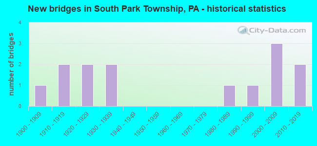
- New bridges - historical statistics
- 11900-1909
- 21910-1919
- 21920-1929
- 21930-1939
- 11980-1989
- 11990-1999
- 32000-2009
- 22010-2019
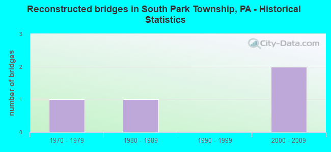
- Reconstructed bridges - Historical Statistics
- 11970-1979
- 11980-1989
- 01990-1999
- 22000-2009
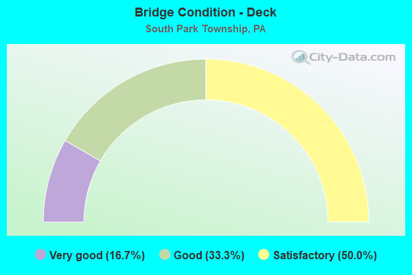
- Bridge Condition - Deck
- 16.7%Very good
- 33.3%Good
- 50.0%Satisfactory
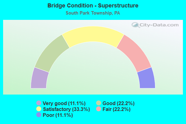
- Bridge Condition - Superstructure
- 11.1%Very good
- 22.2%Good
- 33.3%Satisfactory
- 22.2%Fair
- 11.1%Poor
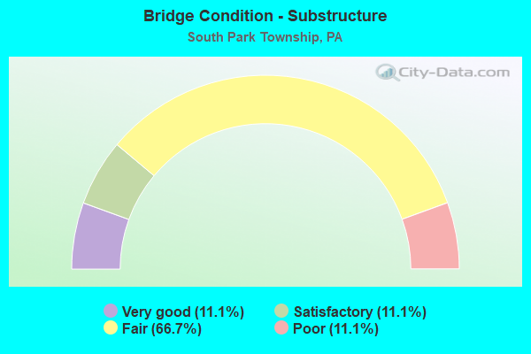
- Bridge Condition - Substructure
- 11.1%Very good
- 11.1%Satisfactory
- 66.7%Fair
- 11.1%Poor
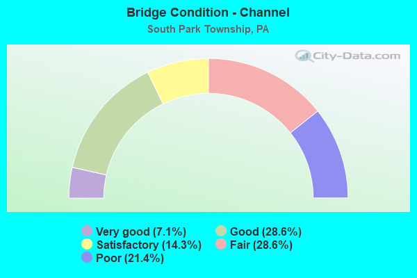
- Bridge Condition - Channel
- 7.1%Very good
- 28.6%Good
- 14.3%Satisfactory
- 28.6%Fair
- 21.4%Poor
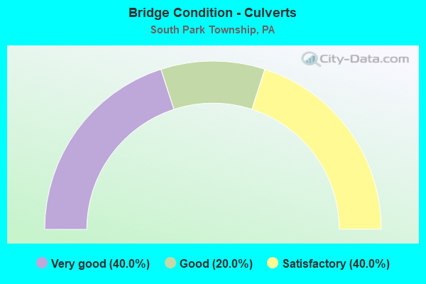
- Bridge Condition - Culverts
- 40.0%Very good
- 20.0%Good
- 40.0%Satisfactory
Find on map >> Show street view
Structure Number: 1708, Location: 250' N OF PINEY FORK RD (Lat: 40.289494, Lng: -80.008528), Route carried "on" structure: State highway , Year Built: 1930, Status: Open, Structure Length: 0.79m (2.59ft), Average Daily Traffic: 1,441 (year 2022), Truck Traffic: 1%, Average Future Daily Traffic: 1,944 (year 2032), Design Load: HS 20, Features Intersected: PINEY FORK CREEK, Facility Carried by Structure: STEWART ROAD
Minimum Vertical Clearance: 30+ m (98+ ft), Kilometerpoint: 0.000, Lanes on structure: 2, Owner: State Highway Agency, Approaching Roadway Width: 7.6m (24.9ft), Material/Design: Masonry, Design/Construction: Arch - Deck, Number Of Spans In Main Unit: 1, Length of Maximum Span: 7.9m (25.9ft), Curb-To-Curb Width: 5.6m (18.4ft), Out-to-Out Width: 6.8m (22.3ft)
Condition: Superstructure: Satisfactory, Substructure: Fair, Channel: Fair, Operating Rating: 49.0 metric tons, Method Used To Determine Operating Rating: Field evaluation and documented engineering judgment, Inventory Rating: 32.7 metric tons, Method Used To Determine Inventory Rating: Field evaluation and documented engineering judgment, Structural Evaluation: Somewhat better than minimum adequacy, Deck Geometry: High priority of replacement, Waterway Adequacy: Equal to present desirable criteria, Approach Roadway Alignment: Equal to present desirable criteria, Length Of Structure Improvement: 1.00m (3.28ft), Designated Inspection Frequency: Every 24 months, Inspection Date: March 2021, Bridge Improvement Cost: $12,000, Roadway Improvement Cost: $36,000, Total Project Cost: $165,000
Find on map >> Show street view
Structure Number: 1719, Location: @ INTER. WITH SR 3014 (Lat: 40.272417, Lng: -79.965361), Route carried "on" structure: State highway , Year Built: 1920, Year Reconstructed: 1978, Status: Open, Structure Length: 1.89m (6.20ft), Average Daily Traffic: 14 (year 2014), Truck Traffic: 5%, Average Future Daily Traffic: 46 (year 2038), Design Load: HS 20, Features Intersected: PETERS CREEK, Facility Carried by Structure: SNOWDEN RD.
Minimum Vertical Clearance: 30+ m (98+ ft), Kilometerpoint: 0.518, Lanes on structure: 2, Owner: State Highway Agency, Approaching Roadway Width: 9.1m (29.9ft), Skew: 1 degrees, Material/Design: Prestressed concrete, Design/Construction: Box Beam or Girders - Multiple, Number Of Spans In Main Unit: 2, Length of Maximum Span: 9.1m (29.9ft), Curb or Sidewalk Widths: Left: 0.2m (0.7ft), Right: 0.2m (0.7ft), Curb-To-Curb Width: 8.5m (27.9ft), Out-to-Out Width: 9.8m (32.2ft)
Condition: Deck: Satisfactory, Superstructure: Satisfactory, Substructure: Fair, Channel: Poor, Operating Rating: 55.3 metric tons, Method Used To Determine Operating Rating: Load Factor (LF), Inventory Rating: 33.6 metric tons, Method Used To Determine Inventory Rating: Load Factor (LF), Structural Evaluation: Somewhat better than minimum adequacy, Deck Geometry: Better than present minimum criteria, Waterway Adequacy: Equal to present desirable criteria, Approach Roadway Alignment: Equal to present desirable criteria, Length Of Structure Improvement: 1.90m (6.23ft), Designated Inspection Frequency: Every 24 months, Inspection Date: May 2021, Bridge Improvement Cost: $5,000, Roadway Improvement Cost: $19,000, Total Project Cost: $62,000, Deck Structure Type: Other, Wearing Surface/Protective System: Wearing Surface: Bituminous
Find on map >> Show street view
Structure Number: 2355, Location: 219004 200 N INT BRWNVLE (Lat: 40.287108, Lng: -80.022342), Route carried "on" structure: Business City street , Year Built: 2002, Status: Open, Structure Length: 1.74m (5.71ft), Average Daily Traffic: 400 (year 2018), Truck Traffic: 5%, Average Future Daily Traffic: 440 (year 2039), Design Load: HS 20, Features Intersected: PINEY FORK CREEK, Facility Carried by Structure: PLEASANT ST
Minimum Vertical Clearance: 30+ m (98+ ft), Kilometerpoint: 0.000, Lanes on structure: 2, Owner: Town or Township Highway Agency, Approaching Roadway Width: 11.0m (36.1ft), Skew: 1 degrees, Material/Design: Prestressed concrete, Design/Construction: Box Beam or Girders - Single/Spread, Number Of Spans In Main Unit: 1, Length of Maximum Span: 16.8m (55.1ft), Curb or Sidewalk Widths: Left: 0.2m (0.7ft), Right: 0.2m (0.7ft), Curb-To-Curb Width: 10.9m (35.8ft), Out-to-Out Width: 11.8m (38.7ft)
Condition: Deck: Satisfactory, Superstructure: Good, Substructure: Satisfactory, Channel: Good, Operating Rating: 71.7 metric tons, Method Used To Determine Operating Rating: Load Factor (LF), Inventory Rating: 42.6 metric tons, Method Used To Determine Inventory Rating: Load Factor (LF), Structural Evaluation: Equal to present minimum criteria, Deck Geometry: Better than present minimum criteria, Waterway Adequacy: Better than present minimum criteria, Approach Roadway Alignment: Equal to present desirable criteria, Length Of Structure Improvement: 2.40m (7.87ft), Designated Inspection Frequency: Every 24 months, Inspection Date: May 2020, Deck Structure Type: Concrete Cast-file-Place, Wearing Surface/Protective System: Wearing Surface: Monolithic Concrete, Membrane: Other, Deck Protection: Epoxy Coated Reinforcing
Find on map >> Show street view
Structure Number: 236, Location: PF01 PINEY FORK # 1 (Lat: 40.281981, Lng: -79.983781), Route carried "on" structure: City street , Year Built: 1902, Year Reconstructed: 2014, Status: Open, Structure Length: 0.91m (2.99ft), Average Daily Traffic: 803 (year 2021), Truck Traffic: 1%, Average Future Daily Traffic: 850 (year 2039), Features Intersected: PINEY FORK, Facility Carried by Structure: TRIPHAMMER RD T315
Minimum Vertical Clearance: 30+ m (98+ ft), Kilometerpoint: 0.000, Lanes on structure: 2, Owner: County Highway Agency, Approaching Roadway Width: 6.1m (20.0ft), Material/Design: Masonry, Design/Construction: Arch - Deck, Number Of Spans In Main Unit: 1, Length of Maximum Span: 9.1m (29.9ft), Curb-To-Curb Width: 6.1m (20.0ft), Out-to-Out Width: 6.7m (22.0ft)
Condition: Deck: Good, Superstructure: Satisfactory, Substructure: Fair, Channel: Poor, Operating Rating: 49.0 metric tons, Method Used To Determine Operating Rating: Field evaluation and documented engineering judgment, Inventory Rating: 32.7 metric tons, Method Used To Determine Inventory Rating: Field evaluation and documented engineering judgment, Structural Evaluation: Somewhat better than minimum adequacy, Deck Geometry: High priority of corrective action, Waterway Adequacy: Equal to present desirable criteria, Approach Roadway Alignment: Equal to present desirable criteria, Length Of Structure Improvement: 1.10m (3.61ft), Designated Inspection Frequency: Every 24 months, Underwater Inspection Frequency: Every 24 months, Inspection Date: March 2021, Underwater Inspection Date: September 2021, Bridge Improvement Cost: $4,000, Roadway Improvement Cost: $33,000, Total Project Cost: $52,000, Deck Structure Type: Concrete Cast-file-Place, Wearing Surface/Protective System: Wearing Surface: Monolithic Concrete, Deck Protection: Epoxy Coated Reinforcing
Find on map >> Show street view
Structure Number: 2365, Location: PF06 PINEY FORK NO. 6 (Lat: 40.288364, Lng: -80.005075), Route carried "on" structure: County highway , Year Built: 1914, Year Reconstructed: 1980, Status: Open, Structure Length: 1.07m (3.51ft), Average Daily Traffic: 8,338 (year 2004), Truck Traffic: 6%, Average Future Daily Traffic: 10,673 (year 2028), Features Intersected: PINEY FORK CREEK, Facility Carried by Structure: BROWNSVILL-LIBR RD
Minimum Vertical Clearance: 30+ m (98+ ft), Kilometerpoint: 0.000, Lanes on structure: 2, Owner: County Highway Agency, Approaching Roadway Width: 9.8m (32.2ft), Skew: 3 degrees, Material/Design: Concrete, Design/Construction: Arch - Deck, Number Of Spans In Main Unit: 1, Length of Maximum Span: 10.7m (35.1ft), Curb or Sidewalk Widths: Left: 0.2m (0.7ft), Right: 0.1m (0.3ft), Curb-To-Curb Width: 10.1m (33.1ft), Out-to-Out Width: 11.1m (36.4ft)
Condition: Superstructure: Fair, Substructure: Fair, Channel: Poor, Operating Rating: 43.5 metric tons, Method Used To Determine Operating Rating: Field evaluation and documented engineering judgment, Inventory Rating: 26.3 metric tons, Method Used To Determine Inventory Rating: Field evaluation and documented engineering judgment, Structural Evaluation: Somewhat better than minimum adequacy, Deck Geometry: Meets minimum limits, Waterway Adequacy: Better than present minimum criteria, Approach Roadway Alignment: Equal to present desirable criteria, Length Of Structure Improvement: 1.10m (3.61ft), Designated Inspection Frequency: Every 24 months, Inspection Date: September 2020, Bridge Improvement Cost: $6,000, Roadway Improvement Cost: $28,000, Total Project Cost: $75,000
Find on map >> Show street view
Structure Number: 2367, Location: CT03 CATFISH RUN NO. 3 (Lat: 40.308303, Lng: -80.000528), Route carried "on" structure: County highway , Year Built: 1920, Year Reconstructed: 2007, Status: Open, Structure Length: 0.76m (2.49ft), Average Daily Traffic: 6,994 (year 2005), Truck Traffic: 10%, Average Future Daily Traffic: 9,000 (year 2025), Design Load: HS 20, Features Intersected: CATFISH RUN, Facility Carried by Structure: CORRIGAN DR
Minimum Vertical Clearance: 30+ m (98+ ft), Kilometerpoint: 0.000, Lanes on structure: 4, Owner: County Highway Agency, Approaching Roadway Width: 15.2m (49.9ft), Skew: 2 degrees, Material/Design: Concrete, Design/Construction: Box Beam or Girders - Single/Spread, Number Of Spans In Main Unit: 1, Length of Maximum Span: 6.4m (21.0ft), Curb or Sidewalk Widths: Left: 3.2m (10.5ft), Right: 3.7m (12.1ft), Curb-To-Curb Width: 14.0m (45.9ft), Out-to-Out Width: 23.6m (77.4ft)
Condition: Deck: Good, Superstructure: Good, Substructure: Fair, Channel: Fair, Inventory Rating: 73.5 metric tons, Method Used To Determine Inventory Rating: Load Factor (LF), Structural Evaluation: Somewhat better than minimum adequacy, Deck Geometry: High priority of replacement, Waterway Adequacy: Equal to present desirable criteria, Approach Roadway Alignment: Equal to present desirable criteria, Length Of Structure Improvement: 0.80m (2.62ft), Designated Inspection Frequency: Every 24 months, Inspection Date: November 2021, Bridge Improvement Cost: $8,000, Roadway Improvement Cost: $28,000, Total Project Cost: $110,000, Deck Structure Type: Concrete Cast-file-Place, Wearing Surface/Protective System: Wearing Surface: Monolithic Concrete, Deck Protection: Epoxy Coated Reinforcing
Find on map >> Show street view
Structure Number: 237, Location: CT05 CATFISH RUN NO. 5 (Lat: 40.315506, Lng: -80.005842), Route carried "on" structure: County highway , Year Built: 1936, Status: Open, Structure Length: 0.61m (2.00ft), Average Daily Traffic: 6,959 (year 2005), Truck Traffic: 10%, Average Future Daily Traffic: 7,700 (year 2025), Features Intersected: CATFISH RUN, Facility Carried by Structure: MAPLE SPRING DR
Minimum Vertical Clearance: 30+ m (98+ ft), Kilometerpoint: 0.000, Lanes on structure: 2, Owner: County Highway Agency, Approaching Roadway Width: 7.3m (24.0ft), Material/Design: Steel, Design/Construction: Arch - Deck, Number Of Spans In Main Unit: 1, Length of Maximum Span: 6.1m (20.0ft), Curb or Sidewalk Widths: Left: 1.6m (5.2ft), Right: 1.6m (5.2ft), Curb-To-Curb Width: 7.3m (24.0ft), Out-to-Out Width: 12.3m (40.4ft)
Condition: Superstructure: Fair, Substructure: Fair, Channel: Fair, Operating Rating: 53.5 metric tons, Method Used To Determine Operating Rating: Field evaluation and documented engineering judgment, Inventory Rating: 31.8 metric tons, Method Used To Determine Inventory Rating: Field evaluation and documented engineering judgment, Structural Evaluation: Somewhat better than minimum adequacy, Deck Geometry: High priority of replacement, Waterway Adequacy: Better than present minimum criteria, Approach Roadway Alignment: Equal to present desirable criteria, Length Of Structure Improvement: 0.60m (1.97ft), Designated Inspection Frequency: Every 24 months, Inspection Date: November 2021, Bridge Improvement Cost: $6,000, Roadway Improvement Cost: $25,000, Total Project Cost: $83,000
Find on map >> Show street view
Structure Number: 2609, Location: LC06 LICK RUN NO. 6 (Lat: 40.320156, Lng: -79.981650), Route carried "on" structure: County highway , Year Built: 1989, Status: Open, Structure Length: 1.13m (3.71ft), Average Daily Traffic: 4,660 (year 2017), Truck Traffic: 5%, Average Future Daily Traffic: 4,660 (year 2037), Design Load: HS 25 or greater, Features Intersected: LICK RUN, Facility Carried by Structure: BROUGHTON-COCHRANS
Minimum Vertical Clearance: 30+ m (98+ ft), Kilometerpoint: 0.000, Lanes on structure: 2, Owner: County Highway Agency, Approaching Roadway Width: 9.8m (32.2ft), Skew: 5 degrees, Material/Design: Concrete, Design/Construction: Culvert, Number Of Spans In Main Unit: 1, Length of Maximum Span: 11.3m (37.1ft), Curb-To-Curb Width: 9.8m (32.2ft), Out-to-Out Width: 15.2m (49.9ft)
Condition: Channel: Good, Culverts: Satisfactory, Operating Rating: 66.2 metric tons, Method Used To Determine Operating Rating: Load Factor (LF), Inventory Rating: 39.9 metric tons, Method Used To Determine Inventory Rating: Load Factor (LF), Structural Evaluation: Equal to present minimum criteria, Deck Geometry: Meets minimum limits, Waterway Adequacy: Equal to present desirable criteria, Approach Roadway Alignment: Equal to present desirable criteria, Length Of Structure Improvement: 1.10m (3.61ft), Designated Inspection Frequency: Every 24 months, Inspection Date: November 2021
Find on map >> Show street view
Structure Number: 35346, Location: 2000' NORTH OF SR 1008 (Lat: 40.265508, Lng: -79.982364), Route carried "on" structure: City street T844, Year Built: 1912, Status: Posted for load, Structure Length: 2.07m (6.79ft), Average Daily Traffic: 5 (year 1993), Average Future Daily Traffic: 5 (year 2000), Design Load: H 15, Features Intersected: PETERS CREEK, Facility Carried by Structure: ESTEP BRIDGE TR844
Minimum Vertical Clearance: 30+ m (98+ ft), Kilometerpoint: 0.000, Lanes on structure: 1, Base Highway Network: Yes, Owner: County Highway Agency, Approaching Roadway Width: 2.7m (8.9ft), Material/Design: Steel, Design/Construction: Truss - Thru, Number Of Spans In Main Unit: 1, Length of Maximum Span: 19.5m (64.0ft), Curb-To-Curb Width: 3.7m (12.1ft), Out-to-Out Width: 4.3m (14.1ft)
Condition: Deck: Satisfactory, Superstructure: Poor, Substructure: Poor, Channel: Fair, Operating Rating: 10.0 metric tons, Method Used To Determine Operating Rating: Allowable Stress (AS), Inventory Rating: 7.3 metric tons, Method Used To Determine Inventory Rating: Allowable Stress (AS), Structural Evaluation: High priority of replacement, Deck Geometry: Meets minimum limits, Waterway Adequacy: Better than present minimum criteria, Approach Roadway Alignment: Somewhat better than minimum adequacy, Bridge Posting: Required (Relationship of Operating Rating to Maximum Legal Load: > 39.9% below), Length Of Structure Improvement: 2.70m (8.86ft), Designated Inspection Frequency: Every 24 months, Critical Feature Inspection Frequency: Every 12 months, Other Special Inspection Frequency: Every 6 months, Inspection Date: June 2021, Critical Feature Inspection Date: June 2021, Other Special Inspection Date: September 2021, Bridge Improvement Cost: $15,000, Roadway Improvement Cost: $45,000, Total Project Cost: $205,000, Deck Structure Type: Wood or Timber
Find on map >> Show street view
Structure Number: 40597, Location: 1000 FT NW OF SR 3017 (Lat: 40.277867, Lng: -79.957000), Route carried "on" structure: State highway , Year Built: 1999, Status: Open, Structure Length: 1.25m (4.10ft), Average Daily Traffic: 595 (year 2022), Truck Traffic: 3%, Average Future Daily Traffic: 1,183 (year 2032), Design Load: HS 20, Features Intersected: LICK RUN, Facility Carried by Structure: PETER CK RD EXT
Minimum Vertical Clearance: 30+ m (98+ ft), Kilometerpoint: 5.015, Lanes on structure: 2, Owner: State Highway Agency, Approaching Roadway Width: 10.4m (34.1ft), Material/Design: Concrete, Design/Construction: Culvert, Number Of Spans In Main Unit: 2, Length of Maximum Span: 6.1m (20.0ft), Curb-To-Curb Width: 10.4m (34.1ft), Out-to-Out Width: 11.3m (37.1ft)
Condition: Channel: Satisfactory, Culverts: Good, Operating Rating: 86.2 metric tons, Method Used To Determine Operating Rating: Load Factor (LF), Inventory Rating: 50.8 metric tons, Method Used To Determine Inventory Rating: Load Factor (LF), Structural Evaluation: Better than present minimum criteria, Deck Geometry: Equal to present minimum criteria, Waterway Adequacy: Superior to present desirable criteria, Approach Roadway Alignment: Equal to present desirable criteria, Length Of Structure Improvement: 1.20m (3.94ft), Designated Inspection Frequency: Every 24 months, Inspection Date: May 2021
Find on map >> Show street view
Structure Number: 44979, Location: South Park (Lat: 40.286967, Lng: -79.996233), Route carried "on" structure: State highway , Year Built: 2008, Status: Open, Structure Length: 0.98m (3.22ft), Average Daily Traffic: 4,462 (year 2020), Truck Traffic: 2%, Average Future Daily Traffic: 4,861 (year 2032), Design Load: HS 25 or greater, Features Intersected: Piney Fork, Facility Carried by Structure: Brownsville Rd Ext
Minimum Vertical Clearance: 30+ m (98+ ft), Kilometerpoint: 0.761, Lanes on structure: 2, Owner: State Highway Agency, Approaching Roadway Width: 11.9m (39.0ft), Skew: 1 degrees, Material/Design: Concrete, Design/Construction: Culvert, Number Of Spans In Main Unit: 1, Length of Maximum Span: 9.8m (32.2ft), Curb or Sidewalk Widths: Left: 0.3m (1.0ft), Right: 0.3m (1.0ft)
Condition: Channel: Satisfactory, Culverts: Very good, Operating Rating: 51.7 metric tons, Method Used To Determine Operating Rating: Load Factor (LF), Inventory Rating: 33.6 metric tons, Method Used To Determine Inventory Rating: Load Factor (LF), Structural Evaluation: Equal to present desirable criteria, Waterway Adequacy: Equal to present minimum criteria, Approach Roadway Alignment: Equal to present desirable criteria, Designated Inspection Frequency: Every 24 months, Inspection Date: May 2021
Find on map >> Show street view
Structure Number: 49137, Location: BTW T976 & SR3013 (Lat: 40.294967, Lng: -79.992650), Route carried "on" structure: City street 7219, Year Built: 2007, Status: Open, Structure Length: 0.70m (2.30ft), Average Daily Traffic: 5,000 (year 2019), Truck Traffic: 1%, Average Future Daily Traffic: 8,750 (year 2039), Design Load: HS 20, Features Intersected: Catfish Run, Facility Carried by Structure: T325, WALLACE ROAD
Minimum Vertical Clearance: 30+ m (98+ ft), Kilometerpoint: 0.000, Lanes on structure: 2, Owner: Town or Township Highway Agency, Approaching Roadway Width: 9.4m (30.8ft), Skew: 2 degrees, Material/Design: Concrete, Design/Construction: Culvert, Number Of Spans In Main Unit: 1, Length of Maximum Span: 6.7m (22.0ft)
Condition: Channel: Good, Culverts: Satisfactory, Operating Rating: 49.0 metric tons, Method Used To Determine Operating Rating: Field evaluation and documented engineering judgment, Inventory Rating: 32.7 metric tons, Method Used To Determine Inventory Rating: Field evaluation and documented engineering judgment, Structural Evaluation: Equal to present minimum criteria, Waterway Adequacy: Better than present minimum criteria, Approach Roadway Alignment: Equal to present desirable criteria, Designated Inspection Frequency: Every 24 months, Inspection Date: June 2021
Find on map >> Show street view
Structure Number: 52644, Location: 3/4 MI NW of SR 3015 (Lat: 40.278361, Lng: -79.977239), Route carried "on" structure: State highway , Year Built: 2015, Status: Open, Structure Length: 1.37m (4.49ft), Average Daily Traffic: 595 (year 2022), Truck Traffic: 3%, Average Future Daily Traffic: 1,183 (year 2034), Design Load: HL 93, Features Intersected: Piney Fork Creek, Facility Carried by Structure: Piney Fork Rd
Minimum Vertical Clearance: 30+ m (98+ ft), Kilometerpoint: 1.881, Lanes on structure: 2, Owner: State Highway Agency, Maintenance Responsibility: Private, Approaching Roadway Width: 7.3m (24.0ft), Skew: 2 degrees, Material/Design: Prestressed concrete, Design/Construction: Box Beam or Girders - Single/Spread, Number Of Spans In Main Unit: 1, Length of Maximum Span: 13.1m (43.0ft), Curb-To-Curb Width: 9.8m (32.2ft), Out-to-Out Width: 10.4m (34.1ft)
Condition: Deck: Very good, Superstructure: Very good, Substructure: Very good, Channel: Good, Operating Rating: 70.3 metric tons, Method Used To Determine Operating Rating: Assigned ratings based on Load and Resistance Factor Design (LRFD) reported by rating factor (RF) using HL93 loadings, Inventory Rating: 54.4 metric tons, Method Used To Determine Inventory Rating: Assigned ratings based on Load and Resistance Factor Design (LRFD) reported by rating factor (RF) using HL93 loadings, Structural Evaluation: Equal to present desirable criteria, Deck Geometry: Equal to present minimum criteria, Waterway Adequacy: Better than present minimum criteria, Approach Roadway Alignment: Somewhat better than minimum adequacy, Designated Inspection Frequency: Every 24 months, Inspection Date: July 2021, Deck Structure Type: Concrete Cast-file-Place, Wearing Surface/Protective System: Wearing Surface: Integral Concrete, Deck Protection: Epoxy Coated Reinforcing
Find on map >> Show street view
Structure Number: 54748, Location: @ S.PARK SEWAGE PLANT (Lat: 40.287353, Lng: -79.991028), Route carried "on" structure: State highway , Year Built: 2018, Status: Open, Structure Length: 0.64m (2.10ft), Average Daily Traffic: 3,741 (year 2022), Truck Traffic: 6%, Average Future Daily Traffic: 4,220 (year 2037), Design Load: HL 93, Features Intersected: CATFISH RUN, Facility Carried by Structure: PINEY FORK RD
Minimum Vertical Clearance: 30+ m (98+ ft), Kilometerpoint: 0.000, Lanes on structure: 2, Owner: State Highway Agency, Maintenance Responsibility: Private, Approaching Roadway Width: 7.9m (25.9ft), Material/Design: Concrete, Design/Construction: Culvert, Number Of Spans In Main Unit: 1, Length of Maximum Span: 6.4m (21.0ft), Curb-To-Curb Width: 8.5m (27.9ft), Out-to-Out Width: 9.9m (32.5ft)
Condition: Channel: Very good, Culverts: Very good, Operating Rating: 50.5 metric tons, Method Used To Determine Operating Rating: Assigned ratings based on Load and Resistance Factor Design (LRFD) reported by rating factor (RF) using HL93 loadings, Inventory Rating: 33.4 metric tons, Method Used To Determine Inventory Rating: Assigned ratings based on Load and Resistance Factor Design (LRFD) reported by rating factor (RF) using HL93 loadings, Structural Evaluation: Equal to present desirable criteria, Deck Geometry: Meets minimum limits, Waterway Adequacy: Better than present minimum criteria, Approach Roadway Alignment: Equal to present desirable criteria, Designated Inspection Frequency: Every 24 months, Inspection Date: October 2020, Wearing Surface/Protective System: Wearing Surface: Bituminous, Membrane: Preformed Fabric, Deck Protection: Epoxy Coated Reinforcing