Bridge Statistics for South Uniontown, Pennsylvania (PA)
Condition, Traffic, Stress, Structural Evaluation, Project Costs
- National Bridge Inventory (NBI) Statistics
- 10Number of bridges
- 66ft / 20.0mTotal length
- $1,018,000Total costs
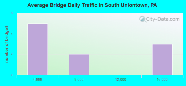
- 68,388Total average daily traffic
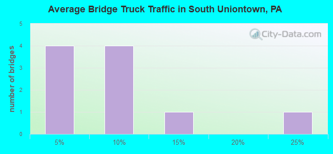
- 5,022Total average daily truck traffic
- National Bridge Inventory (NBI) Registered Bridges for South Uniontown
- No street view available for this location
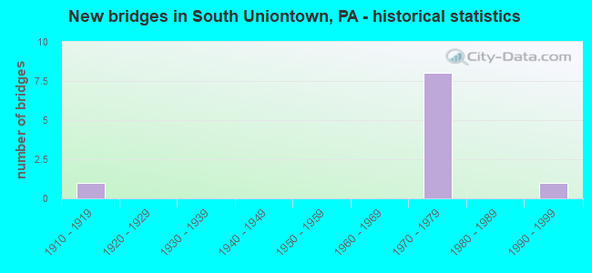
- New bridges - historical statistics
- 11910-1919
- 81970-1979
- 11990-1999
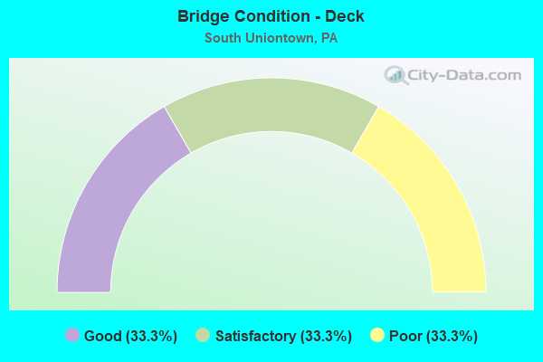
- Bridge Condition - Deck
- 33.3%Good
- 33.3%Satisfactory
- 33.3%Poor
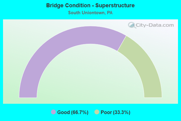
- Bridge Condition - Superstructure
- 66.7%Good
- 33.3%Poor
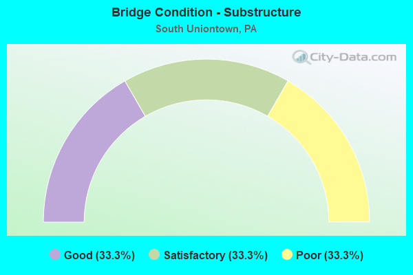
- Bridge Condition - Substructure
- 33.3%Good
- 33.3%Satisfactory
- 33.3%Poor
Find on map >> Show street view
Structure Number: 16557, Location: SOUTH UNION TOWNSHIP (Lat: 39.899025, Lng: -79.749575), Route carried "on" structure: Bypass US 40, Year Built: 1971, Status: Open, Structure Length: 5.79m (19.00ft), Average Daily Traffic: 14,805 (year 2022), Truck Traffic: 9%, Average Future Daily Traffic: 14,020 (year 2032), Design Load: HS 20, Features Intersected: SR 8005
Minimum Vertical Clearance: 30+ m (98+ ft), Kilometerpoint: 19.179, Lanes on structure: 3, Lanes under structure: 4, Base Highway Network: Yes, Owner: State Highway Agency, Approaching Roadway Width: 16.2m (53.1ft), Skew: 10 degrees, Material/Design: Prestressed concrete, Design/Construction: Stringer/Multi-beam, Number Of Spans In Main Unit: 3, Length of Maximum Span: 30.5m (100.1ft), Curb or Sidewalk Widths: Left: 0.3m (1.0ft), Right: 0.3m (1.0ft), Curb-To-Curb Width: 16.2m (53.1ft), Out-to-Out Width: 17.5m (57.4ft)
Condition: Deck: Satisfactory, Superstructure: Good, Substructure: Good, Operating Rating: 46.3 metric tons, Method Used To Determine Operating Rating: Load Factor (LF), Inventory Rating: 27.2 metric tons, Method Used To Determine Inventory Rating: Load Factor (LF), Structural Evaluation: Equal to present minimum criteria, Deck Geometry: Equal to present minimum criteria, Underclear: Meets minimum limits, Approach Roadway Alignment: Equal to present desirable criteria, Length Of Structure Improvement: 6.80m (22.31ft), Designated Inspection Frequency: Every 24 months, Inspection Date: November 2020, Deck Structure Type: Concrete Cast-file-Place, Wearing Surface/Protective System: Wearing Surface: Bituminous
Find on map >> Show street view
Structure Number: 16883, Location: SOUTH UNION TOWNSHIP (Lat: 39.895956, Lng: -79.753031), Route carried "on" structure: State highway , Year Built: 1971, Status: Open, Structure Length: 12.47m (40.91ft), Average Daily Traffic: 3,940 (year 2022), Truck Traffic: 2%, Average Future Daily Traffic: 6,062 (year 2032), Design Load: HS 20, Features Intersected: SR 0040, Facility Carried by Structure: SR 2031
Minimum Vertical Clearance: 30+ m (98+ ft), Kilometerpoint: 0.000, Lanes on structure: 2, Lanes under structure: 4, Owner: State Highway Agency, Approaching Roadway Width: 8.5m (27.9ft), Skew: 4 degrees, Material/Design: Steel, Design/Construction: Stringer/Multi-beam, Number Of Spans In Main Unit: 2, Number Of Approach Spans: 2, Length of Maximum Span: 39.6m (129.9ft), Curb or Sidewalk Widths: Left: 1.5m (4.9ft), Right: 1.5m (4.9ft), Curb-To-Curb Width: 8.5m (27.9ft), Out-to-Out Width: 12.5m (41.0ft)
Condition: Deck: Good, Superstructure: Good, Substructure: Satisfactory, Operating Rating: 48.1 metric tons, Method Used To Determine Operating Rating: Load Factor (LF), Inventory Rating: 29.0 metric tons, Method Used To Determine Inventory Rating: Load Factor (LF), Structural Evaluation: Equal to present minimum criteria, Deck Geometry: Meets minimum limits, Underclear: Superior to present desirable criteria, Approach Roadway Alignment: Equal to present desirable criteria, Length Of Structure Improvement: 13.50m (44.29ft), Designated Inspection Frequency: Every 24 months, Inspection Date: October 2020, Bridge Improvement Cost: $63,000, Roadway Improvement Cost: $186,000, Total Project Cost: $853,000, Deck Structure Type: Concrete Cast-file-Place, Wearing Surface/Protective System: Wearing Surface: Latex Concrete
Find on map >> Show street view
Structure Number: 16884, Location: SOUTH UNION TOWNSHIP (Lat: 39.895944, Lng: -79.752447), Route carried "on" structure: State highway , Year Built: 1918, Status: Posted for load, Structure Length: 0.79m (2.59ft), Average Daily Traffic: 3,940 (year 2022), Truck Traffic: 2%, Average Future Daily Traffic: 4,500 (year 2043), Design Load: H 15, Features Intersected: COAL LICK RUN, Facility Carried by Structure: SR 2031
Minimum Vertical Clearance: 30+ m (98+ ft), Kilometerpoint: 0.124, Lanes on structure: 2, Owner: State Highway Agency, Approaching Roadway Width: 8.2m (26.9ft), Skew: 1 degrees, Material/Design: Steel, Design/Construction: Stringer/Multi-beam, Number Of Spans In Main Unit: 1, Length of Maximum Span: 7.9m (25.9ft), Curb-To-Curb Width: 6.4m (21.0ft), Out-to-Out Width: 7.6m (24.9ft)
Condition: Deck: Poor, Superstructure: Poor, Substructure: Poor, Channel: Fair, Operating Rating: 58.1 metric tons, Method Used To Determine Operating Rating: Field evaluation and documented engineering judgment, Inventory Rating: 34.5 metric tons, Method Used To Determine Inventory Rating: Field evaluation and documented engineering judgment, Structural Evaluation: Meets minimum limits, Deck Geometry: High priority of replacement, Waterway Adequacy: Meets minimum limits, Approach Roadway Alignment: Equal to present desirable criteria, Length Of Structure Improvement: 1.50m (4.92ft), Designated Inspection Frequency: Every 24 months, Other Special Inspection Frequency: Every 12 months, Inspection Date: Febuary 2021, Other Special Inspection Date: Febuary 2021, Bridge Improvement Cost: $12,000, Roadway Improvement Cost: $36,000, Total Project Cost: $165,000, Wearing Surface/Protective System: Wearing Surface: Bituminous
Find on map >> Show street view
Structure Number: 17137, Location: JUST OFF LEBANON AVE (Lat: 39.894125, Lng: -79.739014), Route carried "on" structure: City street T690, Year Built: 1991, Status: Open, Structure Length: 0.91m (2.99ft), Average Daily Traffic: 25 (year 2006), Truck Traffic: 20%, Average Future Daily Traffic: 175 (year 2000), Design Load: HS 25 or greater, Features Intersected: COAL LICK RUN, Facility Carried by Structure: RAILROAD ST (T960)
Minimum Vertical Clearance: 30+ m (98+ ft), Kilometerpoint: 0.000, Lanes on structure: 2, Owner: Town or Township Highway Agency, Approaching Roadway Width: 5.2m (17.1ft), Skew: 1 degrees, Material/Design: Concrete, Design/Construction: Culvert, Number Of Spans In Main Unit: 2, Length of Maximum Span: 4.0m (13.1ft), Curb-To-Curb Width: 6.7m (22.0ft), Out-to-Out Width: 7.8m (25.6ft)
Condition: Channel: Fair, Culverts: Good, Operating Rating: 67.1 metric tons, Method Used To Determine Operating Rating: Load Factor (LF), Inventory Rating: 39.9 metric tons, Method Used To Determine Inventory Rating: Load Factor (LF), Structural Evaluation: Better than present minimum criteria, Deck Geometry: Somewhat better than minimum adequacy, Waterway Adequacy: Better than present minimum criteria, Approach Roadway Alignment: Equal to present desirable criteria, Length Of Structure Improvement: 1.20m (3.94ft), Designated Inspection Frequency: Every 24 months, Inspection Date: April 2020, Wearing Surface/Protective System: Wearing Surface: Bituminous
Find on map >> Show street view
Structure Number: 16555, Location: SOUTH UNION TOWNSHIP (Lat: 39.899139, Lng: -79.749811), Route carried "under" structure: Ramp State highway , Year Built: 1971, Structure Length: 0. m, Average Daily Traffic: 4,507 (year 2022), Truck Traffic: 3%, Features Intersected: SR 8005, Facility Carried by Structure: SR 0040
Minimum Vertical Clearance: 5.00m (16.40ft), Kilometerpoint: 0.000, Lanes on structure: 2, Lanes under structure: 2, Material/Design: Prestressed concrete, Design/Construction: Stringer/Multi-beam, Length of Maximum Span: 30.5m (100.1ft)
Find on map >> Show street view
Structure Number: 16555, Location: SOUTH UNION TOWNSHIP (Lat: 39.899139, Lng: -79.749811), Route carried "under" structure: Ramp State highway , Year Built: 1971, Structure Length: 0. m, Average Daily Traffic: 3,191 (year 2022), Truck Traffic: 6%, Features Intersected: SR 8005, Facility Carried by Structure: SR 0040
Minimum Vertical Clearance: 5.26m (17.26ft), Kilometerpoint: 0.000, Lanes on structure: 2, Lanes under structure: 2, Material/Design: Prestressed concrete, Design/Construction: Stringer/Multi-beam, Length of Maximum Span: 30.5m (100.1ft)
Find on map >> Show street view
Structure Number: 16557, Location: SOUTH UNION TOWNSHIP (Lat: 39.899025, Lng: -79.749575), Route carried "under" structure: Ramp State highway , Year Built: 1971, Structure Length: 0. m, Average Daily Traffic: 4,507 (year 2022), Truck Traffic: 3%, Features Intersected: SR 8005, Facility Carried by Structure: SR 0040
Minimum Vertical Clearance: 4.75m (15.58ft), Kilometerpoint: 0.000, Lanes on structure: 3, Lanes under structure: 2, Material/Design: Prestressed concrete, Design/Construction: Stringer/Multi-beam, Length of Maximum Span: 30.5m (100.1ft)
Find on map >> Show street view
Structure Number: 16557, Location: SOUTH UNION TOWNSHIP (Lat: 39.899025, Lng: -79.749575), Route carried "under" structure: Ramp State highway , Year Built: 1971, Structure Length: 0. m, Average Daily Traffic: 3,191 (year 2022), Truck Traffic: 6%, Features Intersected: SR 8005, Facility Carried by Structure: SR 0040
Minimum Vertical Clearance: 5.36m (17.59ft), Kilometerpoint: 0.000, Lanes on structure: 3, Lanes under structure: 2, Material/Design: Prestressed concrete, Design/Construction: Stringer/Multi-beam, Length of Maximum Span: 30.5m (100.1ft)
Find on map >> Show street view
Structure Number: 16883, Location: SOUTH UNION TOWNSHIP (Lat: 39.895956, Lng: -79.753031), Route carried "under" structure: Bypass US 40, Year Built: 1971, Structure Length: 0. m, Average Daily Traffic: 15,193 (year 2022), Truck Traffic: 10%, Features Intersected: SR 0040, Facility Carried by Structure: SR 2031
Minimum Vertical Clearance: 7.75m (25.43ft), Kilometerpoint: 20.093, Lanes on structure: 2, Lanes under structure: 4, Material/Design: Steel, Design/Construction: Stringer/Multi-beam, Length of Maximum Span: 39.6m (129.9ft)
Find on map >> Show street view
Structure Number: 16883, Location: SOUTH UNION TOWNSHIP (Lat: 39.895956, Lng: -79.753031), Route carried "under" structure: Bypass US 40, Year Built: 1971, Structure Length: 0. m, Average Daily Traffic: 15,089 (year 2022), Truck Traffic: 9%, Features Intersected: SR 0040, Facility Carried by Structure: SR 2031
Minimum Vertical Clearance: 7.75m (25.43ft), Kilometerpoint: 20.123, Lanes on structure: 2, Lanes under structure: 4, Material/Design: Steel, Design/Construction: Stringer/Multi-beam, Length of Maximum Span: 39.6m (129.9ft)