Bridge Statistics for Spur, Texas (TX)
Condition, Traffic, Stress, Structural Evaluation, Project Costs
- National Bridge Inventory (NBI) Statistics
- 10Number of bridges
- 118ft / 36mTotal length
- $1,029,000Total costs
- 6,505Total average daily traffic
- 1,055Total average daily truck traffic
- 9,055Total future (year 2030) average daily traffic
- National Bridge Inventory (NBI) Registered Bridges for Spur
- No street view available for this location
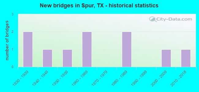
- New bridges - historical statistics
- 21930-1939
- 11940-1949
- 11950-1959
- 21960-1969
- 21980-1989
- 12000-2009
- 12010-2018
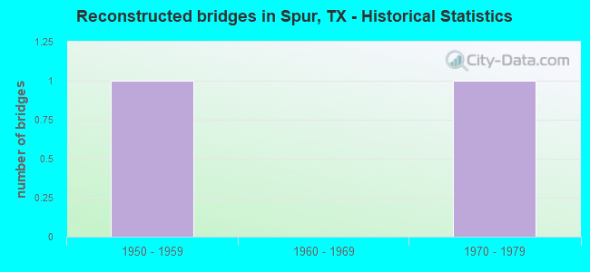
- Reconstructed bridges - Historical Statistics
- 11950-1959
- 01960-1969
- 11970-1979

- Bridge Condition - Deck
- 16.7%Very good
- 50.0%Good
- 16.7%Satisfactory
- 16.7%Poor
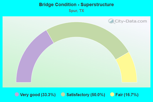
- Bridge Condition - Superstructure
- 33.3%Very good
- 50.0%Satisfactory
- 16.7%Fair
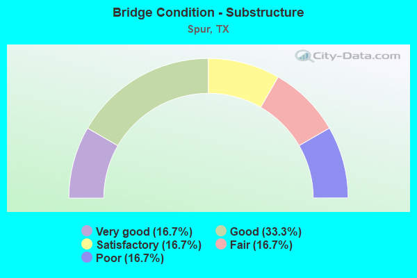
- Bridge Condition - Substructure
- 16.7%Very good
- 33.3%Good
- 16.7%Satisfactory
- 16.7%Fair
- 16.7%Poor
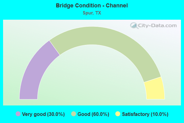
- Bridge Condition - Channel
- 30.0%Very good
- 60.0%Good
- 10.0%Satisfactory
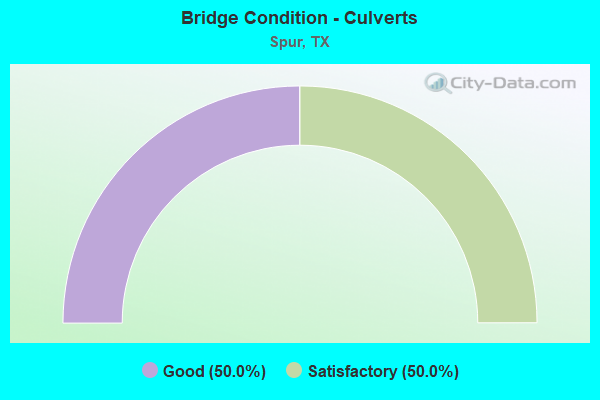
- Bridge Condition - Culverts
- 50.0%Good
- 50.0%Satisfactory
Find on map >> Show street view
Structure Number: 250630010601001, Location: 7.70 MI S OF US 82 (Lat: 33.518889, Lng: -100.856700), Route carried "on" structure: State highway 70, Year Built: 1930, Year Reconstructed: 1962, Status: Posted for load, Structure Length: 8.69m (28.51ft), Average Daily Traffic: 970 (year 2013), Truck Traffic: 18%, Average Future Daily Traffic: 1,360 (year 2033), Features Intersected: DUCK CREEK
Minimum Vertical Clearance: 30+ m (98+ ft), Kilometerpoint: 35.757, Lanes on structure: 2, Owner: State Highway Agency, Approaching Roadway Width: 134.0m (439.6ft), Material/Design: Concrete, Design/Construction: Tee Beam, Number Of Spans In Main Unit: 10, Length of Maximum Span: 8.8m (28.9ft), Curb-To-Curb Width: 13.3m (43.6ft), Out-to-Out Width: 14.3m (46.9ft)
Condition: Deck: Poor, Superstructure: Fair, Substructure: Poor, Channel: Good, Operating Rating: 32.7 metric tons, Method Used To Determine Operating Rating: Field evaluation and documented engineering judgment, Inventory Rating: 24.5 metric tons, Method Used To Determine Inventory Rating: Field evaluation and documented engineering judgment, Structural Evaluation: Meets minimum limits, Deck Geometry: Superior to present desirable criteria, Waterway Adequacy: Equal to present minimum criteria, Approach Roadway Alignment: Somewhat better than minimum adequacy, Length Of Structure Improvement: 86.90m (285.10ft), Designated Inspection Frequency: Every 24 months, Inspection Date: March 2017, Bridge Improvement Cost: $654,000, Roadway Improvement Cost: $65,000, Total Project Cost: $981,000 ( Estimate for 2010), Deck Structure Type: Concrete Cast-file-Place, Wearing Surface/Protective System: Wearing Surface: Bituminous
Find on map >> Show street view
Structure Number: 250630010601046, Location: 10.0 MI S OF US 82 (Lat: 33.486947, Lng: -100.859208), Route carried "on" structure: State highway 70, Year Built: 1962, Status: Open, Structure Length: 0.61m (2.00ft), Average Daily Traffic: 1,260 (year 2013), Truck Traffic: 18%, Average Future Daily Traffic: 1,770 (year 2033), Design Load: H 20, Features Intersected: DOCKUM CREEK
Minimum Vertical Clearance: 30+ m (98+ ft), Kilometerpoint: 39.546, Lanes on structure: 2, Owner: State Highway Agency, Approaching Roadway Width: 128.0m (419.9ft), Material/Design: Concrete, Design/Construction: Stringer/Multi-beam, Number Of Spans In Main Unit: 5, Length of Maximum Span: 12.2m (40.0ft), Curb-To-Curb Width: 13.3m (43.6ft), Out-to-Out Width: 13.9m (45.6ft)
Condition: Deck: Satisfactory, Superstructure: Satisfactory, Substructure: Satisfactory, Channel: Good, Operating Rating: 44.4 metric tons, Method Used To Determine Operating Rating: Load Factor (LF), Inventory Rating: 30.8 metric tons, Method Used To Determine Inventory Rating: Load Factor (LF), Structural Evaluation: Equal to present minimum criteria, Deck Geometry: Better than present minimum criteria, Waterway Adequacy: Equal to present minimum criteria, Approach Roadway Alignment: Equal to present desirable criteria, Designated Inspection Frequency: Every 24 months, Inspection Date: March 2017, Deck Structure Type: Concrete Cast-file-Place, Wearing Surface/Protective System: Wearing Surface: Bituminous
Find on map >> Show street view
Structure Number: 250630010602027, Location: 2.50 MI W OF SH 208 (Lat: 33.462925, Lng: -100.828339), Route carried "on" structure: State highway 70, Year Built: 1935, Year Reconstructed: 1982, Status: Open, Structure Length: 1.43m (4.69ft), Average Daily Traffic: 1,010 (year 2013), Truck Traffic: 18%, Average Future Daily Traffic: 1,410 (year 2033), Design Load: H 15, Features Intersected: DRAW
Minimum Vertical Clearance: 30+ m (98+ ft), Kilometerpoint: 3.429, Lanes on structure: 2, Owner: State Highway Agency, Approaching Roadway Width: 122.0m (400.3ft), Material/Design: Concrete, Design/Construction: Culvert, Number Of Spans In Main Unit: 6, Length of Maximum Span: 2.1m (6.9ft), Curb-To-Curb Width: 12.2m (40.0ft), Out-to-Out Width: 1.3m (4.3ft)
Condition: Channel: Good, Culverts: Satisfactory, Operating Rating: 32.7 metric tons, Method Used To Determine Operating Rating: No rating analysis performed, Inventory Rating: 24.5 metric tons, Method Used To Determine Inventory Rating: No rating analysis performed, Structural Evaluation: Equal to present minimum criteria, Deck Geometry: Better than present minimum criteria, Waterway Adequacy: Equal to present minimum criteria, Approach Roadway Alignment: Equal to present desirable criteria, Designated Inspection Frequency: Every 24 months, Inspection Date: March 2017, Deck Structure Type: Concrete Cast-file-Place, Wearing Surface/Protective System: Wearing Surface: Bituminous
Find on map >> Show street view
Structure Number: 250630010602048, Location: 2.05 MI W OF SH 208 (Lat: 33.460242, Lng: -100.820914), Route carried "on" structure: State highway 70, Year Built: 1981, Status: Open, Structure Length: 1.49m (4.89ft), Average Daily Traffic: 1,010 (year 2013), Truck Traffic: 18%, Average Future Daily Traffic: 1,410 (year 2033), Design Load: HS 20, Features Intersected: DUCK CREEK RELIEF
Minimum Vertical Clearance: 30+ m (98+ ft), Kilometerpoint: 4.175, Lanes on structure: 2, Owner: State Highway Agency, Approaching Roadway Width: 122.0m (400.3ft), Material/Design: Concrete, Design/Construction: Culvert, Number Of Spans In Main Unit: 5, Length of Maximum Span: 2.7m (8.9ft), Curb-To-Curb Width: 13.9m (45.6ft), Out-to-Out Width: 14.6m (47.9ft)
Condition: Channel: Good, Culverts: Good, Operating Rating: 44.4 metric tons, Method Used To Determine Operating Rating: No rating analysis performed, Inventory Rating: 32.7 metric tons, Method Used To Determine Inventory Rating: No rating analysis performed, Structural Evaluation: Better than present minimum criteria, Deck Geometry: Superior to present desirable criteria, Waterway Adequacy: Equal to present minimum criteria, Approach Roadway Alignment: Equal to present desirable criteria, Designated Inspection Frequency: Every 24 months, Inspection Date: March 2017, Deck Structure Type: Concrete Cast-file-Place, Wearing Surface/Protective System: Wearing Surface: Bituminous
Find on map >> Show street view
Structure Number: 250630010602049, Location: 1.70 MI W OF SH 208 (Lat: 33.458353, Lng: -100.815553), Route carried "on" structure: State highway 70, Year Built: 1981, Status: Open, Structure Length: 13.38m (43.90ft), Average Daily Traffic: 1,010 (year 2013), Truck Traffic: 18%, Average Future Daily Traffic: 1,410 (year 2033), Design Load: HS 20, Features Intersected: DUCK CREEK
Minimum Vertical Clearance: 30+ m (98+ ft), Kilometerpoint: 4.713, Lanes on structure: 2, Owner: State Highway Agency, Approaching Roadway Width: 122.0m (400.3ft), Skew: 4 degrees, Material/Design: Concrete, Design/Construction: Stringer/Multi-beam, Number Of Spans In Main Unit: 10, Length of Maximum Span: 13.4m (44.0ft), Curb-To-Curb Width: 12.2m (40.0ft), Out-to-Out Width: 12.9m (42.3ft)
Condition: Deck: Good, Superstructure: Satisfactory, Substructure: Good, Channel: Very good, Operating Rating: 43.5 metric tons, Method Used To Determine Operating Rating: Load Factor (LF), Inventory Rating: 26.3 metric tons, Method Used To Determine Inventory Rating: Load Factor (LF), Structural Evaluation: Equal to present minimum criteria, Deck Geometry: Better than present minimum criteria, Waterway Adequacy: Equal to present minimum criteria, Approach Roadway Alignment: Equal to present desirable criteria, Designated Inspection Frequency: Every 24 months, Inspection Date: March 2017, Deck Structure Type: Concrete Cast-file-Place, Wearing Surface/Protective System: Wearing Surface: Bituminous
Find on map >> Show street view
Structure Number: 250630065104007, Location: 0.25 MI E OF FM 2794 (Lat: 33.479053, Lng: -100.869108), Route carried "on" structure: State highway 836, Year Built: 1941, Status: Open, Structure Length: 0.07m (0.23ft), Average Daily Traffic: 860 (year 2013), Truck Traffic: 11%, Average Future Daily Traffic: 1,210 (year 2033), Features Intersected: DRAW
Minimum Vertical Clearance: 30+ m (98+ ft), Kilometerpoint: 25.316, Lanes on structure: 2, Owner: State Highway Agency, Approaching Roadway Width: 61.0m (200.1ft), Material/Design: Concrete, Design/Construction: Culvert, Number Of Spans In Main Unit: 4, Length of Maximum Span: 1.5m (4.9ft), Curb-To-Curb Width: 11.6m (38.1ft), Out-to-Out Width: 12.3m (40.4ft)
Condition: Channel: Good, Culverts: Good, Operating Rating: 44.4 metric tons, Method Used To Determine Operating Rating: No rating analysis performed, Inventory Rating: 32.7 metric tons, Method Used To Determine Inventory Rating: No rating analysis performed, Structural Evaluation: Better than present minimum criteria, Deck Geometry: Better than present minimum criteria, Waterway Adequacy: Equal to present minimum criteria, Approach Roadway Alignment: Equal to present desirable criteria, Designated Inspection Frequency: Every 24 months, Inspection Date: March 2017, Deck Structure Type: Concrete Cast-file-Place, Wearing Surface/Protective System: Wearing Surface: Bituminous
Find on map >> Show street view
Structure Number: 250630094901004, Location: 1.10 MI S OF LOOP 21 (Lat: 33.461639, Lng: -100.860578), Route carried "on" structure: State highway 261, Year Built: 1957, Status: Open, Structure Length: 1.65m (5.41ft), Average Daily Traffic: 180 (year 2013), Truck Traffic: 10%, Average Future Daily Traffic: 260 (year 2033), Design Load: HS 20, Features Intersected: SPADE DRAW
Minimum Vertical Clearance: 30+ m (98+ ft), Kilometerpoint: 21.282, Lanes on structure: 2, Owner: State Highway Agency, Approaching Roadway Width: 79.0m (259.2ft), Material/Design: Concrete, Design/Construction: Culvert, Number Of Spans In Main Unit: 5, Length of Maximum Span: 0.3m (1.0ft), Curb-To-Curb Width: 10.4m (34.1ft), Out-to-Out Width: 1.2m (3.9ft)
Condition: Channel: Good, Culverts: Satisfactory, Operating Rating: 44.4 metric tons, Method Used To Determine Operating Rating: No rating analysis performed, Inventory Rating: 32.7 metric tons, Method Used To Determine Inventory Rating: No rating analysis performed, Structural Evaluation: Equal to present minimum criteria, Deck Geometry: Better than present minimum criteria, Waterway Adequacy: Equal to present minimum criteria, Approach Roadway Alignment: Equal to present desirable criteria, Designated Inspection Frequency: Every 24 months, Inspection Date: March 2017, Deck Structure Type: Concrete Cast-file-Place, Wearing Surface/Protective System: Wearing Surface: Bituminous
Find on map >> Show street view
Structure Number: 250630AA0104001, Location: 0.35 MI S OF FM 1868 (Lat: 33.496403, Lng: -100.896947), Route carried "on" structure: County highway , Year Built: 2016, Status: Open, Structure Length: 2.44m (8.01ft), Average Daily Traffic: 90 (year 2014), Average Future Daily Traffic: 110 (year 2034), Features Intersected: DOCKUM CREEK, Facility Carried by Structure: CO RD 423
Minimum Vertical Clearance: 30+ m (98+ ft), Kilometerpoint: 0.161, Lanes on structure: 2, Owner: County Highway Agency, Approaching Roadway Width: 94.0m (308.4ft), Skew: 3 degrees, Material/Design: Prestressed concrete, Number Of Spans In Main Unit: 2, Length of Maximum Span: 1.2m (3.9ft), Curb-To-Curb Width: 9.8m (32.2ft), Out-to-Out Width: 10.4m (34.1ft)
Condition: Deck: Very good, Superstructure: Very good, Substructure: Very good, Channel: Very good, Operating Rating: 44.4 metric tons, Method Used To Determine Operating Rating: No rating analysis performed, Inventory Rating: 32.7 metric tons, Method Used To Determine Inventory Rating: No rating analysis performed, Structural Evaluation: Equal to present desirable criteria, Deck Geometry: Equal to present desirable criteria, Waterway Adequacy: Equal to present desirable criteria, Approach Roadway Alignment: Equal to present desirable criteria, Designated Inspection Frequency: Every 24 months, Inspection Date: September 2016, Deck Structure Type: Concrete Cast-file-Place, Wearing Surface/Protective System: Wearing Surface: Monolithic Concrete
Find on map >> Show street view
Structure Number: 250630AA0147001, Location: 0.45 MI S OF SH 70 (Lat: 33.448375, Lng: -100.807033), Route carried "on" structure: County highway , Year Built: 2004, Status: Open, Structure Length: 3.51m (11.52ft), Average Daily Traffic: 15 (year 2010), Average Future Daily Traffic: 15 (year 2030), Design Load: HS 20, Features Intersected: DUCK CREEK, Facility Carried by Structure: CO RD 339
Minimum Vertical Clearance: 30+ m (98+ ft), Kilometerpoint: 5.471, Lanes on structure: 2, Owner: County Highway Agency, Approaching Roadway Width: 67.0m (219.8ft), Material/Design: Prestressed concrete, Design/Construction: Stringer/Multi-beam, Number Of Spans In Main Unit: 1, Length of Maximum Span: 35.1m (115.2ft), Curb-To-Curb Width: 7.2m (23.6ft), Out-to-Out Width: 7.9m (25.9ft)
Condition: Deck: Good, Superstructure: Very good, Substructure: Good, Channel: Very good, Operating Rating: 44.4 metric tons, Method Used To Determine Operating Rating: No rating analysis performed, Inventory Rating: 32.7 metric tons, Method Used To Determine Inventory Rating: No rating analysis performed, Structural Evaluation: Better than present minimum criteria, Deck Geometry: Somewhat better than minimum adequacy, Waterway Adequacy: Equal to present desirable criteria, Approach Roadway Alignment: Equal to present desirable criteria, Length Of Structure Improvement: 35.10m (115.16ft), Designated Inspection Frequency: Every 24 months, Inspection Date: September 2016, Deck Structure Type: Concrete Cast-file-Place, Wearing Surface/Protective System: Wearing Surface: Monolithic Concrete
Find on map >> Show street view
Structure Number: 250630AA0228001, Location: 0.80 MI E OF SH 70 (Lat: 33.477300, Lng: -100.833289), Route carried "on" structure: County highway , Year Built: 1965, Status: Open, Structure Length: 3.66m (12.01ft), Average Daily Traffic: 100 (year 2010), Average Future Daily Traffic: 100 (year 2030), Features Intersected: DUCK CREEK, Facility Carried by Structure: CO RD 384
Minimum Vertical Clearance: 30+ m (98+ ft), Kilometerpoint: 1.529, Lanes on structure: 1, Owner: County Highway Agency, Approaching Roadway Width: 61.0m (200.1ft), Material/Design: Steel continuous, Design/Construction: Stringer/Multi-beam, Number Of Spans In Main Unit: 4, Length of Maximum Span: 9.1m (29.9ft), Curb-To-Curb Width: 4.8m (15.7ft), Out-to-Out Width: 4.8m (15.7ft)
Condition: Deck: Good, Superstructure: Satisfactory, Substructure: Fair, Channel: Satisfactory, Operating Rating: 37.2 metric tons, Method Used To Determine Operating Rating: Allowable Stress (AS), Inventory Rating: 24.5 metric tons, Method Used To Determine Inventory Rating: Allowable Stress (AS), Structural Evaluation: Somewhat better than minimum adequacy, Deck Geometry: Equal to present desirable criteria, Waterway Adequacy: Better than present minimum criteria, Approach Roadway Alignment: Better than present minimum criteria, Length Of Structure Improvement: 36.60m (120.08ft), Designated Inspection Frequency: Every 24 months, Critical Feature Inspection Frequency: Every 24 months, Inspection Date: September 2016, Critical Feature Inspection Date: September 2017, Bridge Improvement Cost: $38,000, Roadway Improvement Cost: $10,000, Total Project Cost: $48,000, Deck Structure Type: Concrete Cast-file-Place, Wearing Surface/Protective System: Wearing Surface: Monolithic Concrete