Bridge Statistics for St. Peters, Missouri (MO)
Condition, Traffic, Stress, Structural Evaluation, Project Costs
- National Bridge Inventory (NBI) Statistics
- 140Number of bridges
- 1,401ft / 427mTotal length
- $2,750,000Total costs
- 2,480,048Total average daily traffic
- 197,909Total average daily truck traffic
- National Bridge Inventory (NBI) Registered Bridges for St. Peters
- No street view available for this location
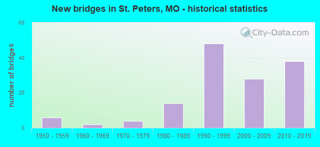
- New bridges - historical statistics
- 61950-1959
- 21960-1969
- 41970-1979
- 141980-1989
- 481990-1999
- 282000-2009
- 382010-2019
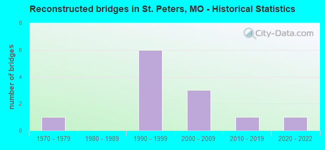
- Reconstructed bridges - Historical Statistics
- 11970-1979
- 01980-1989
- 61990-1999
- 32000-2009
- 12010-2019
- 12020-2022
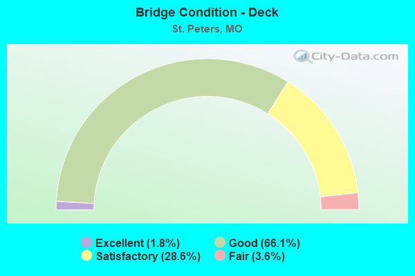
- Bridge Condition - Deck
- 1.8%Excellent
- 66.1%Good
- 28.6%Satisfactory
- 3.6%Fair
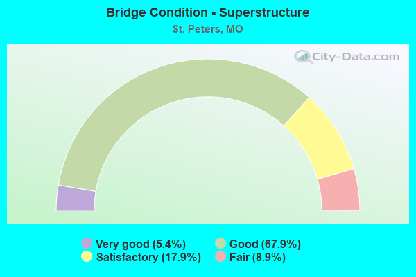
- Bridge Condition - Superstructure
- 5.4%Very good
- 67.9%Good
- 17.9%Satisfactory
- 8.9%Fair
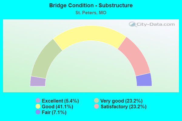
- Bridge Condition - Substructure
- 5.4%Excellent
- 23.2%Very good
- 41.1%Good
- 23.2%Satisfactory
- 7.1%Fair
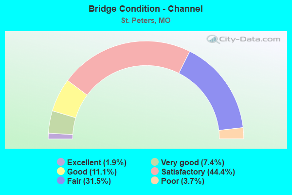
- Bridge Condition - Channel
- 1.9%Excellent
- 7.4%Very good
- 11.1%Good
- 44.4%Satisfactory
- 31.5%Fair
- 3.7%Poor
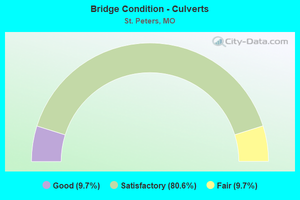
- Bridge Condition - Culverts
- 9.7%Good
- 80.6%Satisfactory
- 9.7%Fair
Find on map >> Show street view
Structure Number: 928, Location: S 3280 T 47 N R 4 E (Lat: 38.786269, Lng: -90.528525), Route carried "on" structure: ServiceState highway 70, Year Built: 1963, Year Reconstructed: 1981, Status: Open, Structure Length: 1.08m (3.54ft), Average Daily Traffic: 11,268 (year 2021), Truck Traffic: 5%, Average Future Daily Traffic: 20,282 (year 2041), Design Load: HS 20, Features Intersected: COLE CR
Minimum Vertical Clearance: 30+ m (98+ ft), Kilometerpoint: 8.581, Lanes on structure: 4, Owner: State Highway Agency, Approaching Roadway Width: 20.7m (67.9ft), Skew: 1 degrees, Material/Design: Concrete continuous, Design/Construction: Culvert, Number Of Spans In Main Unit: 3, Length of Maximum Span: 3.4m (11.2ft)
Condition: Channel: Satisfactory, Culverts: Fair, Inventory Rating: 63.9 metric tons, Method Used To Determine Inventory Rating: Load Factor (LF), Structural Evaluation: Somewhat better than minimum adequacy, Waterway Adequacy: Equal to present minimum criteria, Approach Roadway Alignment: Equal to present desirable criteria, Designated Inspection Frequency: Every 24 months, Inspection Date: November 2021
Find on map >> Show street view
Structure Number: 11738, Location: S 29 T 47 N R 4 E (Lat: 38.798911, Lng: -90.591611), Route carried "under" structure: Interstate 70, Year Built: 1994, Structure Length: 0. m, Average Daily Traffic: 47,958 (year 2021), Truck Traffic: 12%, Features Intersected: IS 70
Minimum Vertical Clearance: 5.18m (16.99ft), Kilometerpoint: 360.165, Lanes on structure: 1, Lanes under structure: 3, Material/Design: Steel continuous, Design/Construction: Stringer/Multi-beam, Length of Maximum Span: 40.5m (132.9ft)
Find on map >> Show street view
Structure Number: 11738, Location: S 29 T 47 N R 4 E (Lat: 38.798911, Lng: -90.591611), Route carried "under" structure: Interstate 70, Year Built: 1994, Structure Length: 0. m, Average Daily Traffic: 47,356 (year 2021), Truck Traffic: 12%, Features Intersected: IS 70
Minimum Vertical Clearance: 5.18m (16.99ft), Kilometerpoint: 42.392, Lanes on structure: 1, Lanes under structure: 3, Material/Design: Steel continuous, Design/Construction: Stringer/Multi-beam, Length of Maximum Span: 40.5m (132.9ft)
Find on map >> Show street view
Structure Number: 11738, Location: S 29 T 47 N R 4 E (Lat: 38.798911, Lng: -90.591611), Route carried "under" structure: State highway 370, Year Built: 1994, Structure Length: 0. m, Average Daily Traffic: 15,863 (year 2021), Truck Traffic: 5%, Features Intersected: MO 370
Minimum Vertical Clearance: 8.25m (27.07ft), Kilometerpoint: 19.977, Lanes on structure: 1, Lanes under structure: 3, Material/Design: Steel continuous, Design/Construction: Stringer/Multi-beam, Length of Maximum Span: 40.5m (132.9ft)
Find on map >> Show street view
Structure Number: 11738, Location: S 29 T 47 N R 4 E (Lat: 38.798911, Lng: -90.591611), Route carried "under" structure: State highway 370, Year Built: 1994, Structure Length: 0. m, Average Daily Traffic: 13,188 (year 2021), Truck Traffic: 5%, Features Intersected: MO 370
Minimum Vertical Clearance: 12.85m (42.16ft), Kilometerpoint: 0.510, Lanes on structure: 1, Lanes under structure: 3, Material/Design: Steel continuous, Design/Construction: Stringer/Multi-beam, Length of Maximum Span: 40.5m (132.9ft)
Find on map >> Show street view
Structure Number: 11739, Location: S 1786 T 47 N R 4 E (Lat: 38.817486, Lng: -90.561161), Route carried "under" structure: City street , Year Built: 1995, Structure Length: 0. m, Average Daily Traffic: 2,000 (year 2021), Truck Traffic: 10%, Features Intersected: CST LAKESIDE PARK DR, Facility Carried by Structure: MO 370 E
Minimum Vertical Clearance: 5.49m (18.01ft), Kilometerpoint: 0.845, Lanes on structure: 3, Lanes under structure: 4, Material/Design: Prestressed concrete continuous, Design/Construction: Stringer/Multi-beam, Length of Maximum Span: 23.8m (78.1ft)
Find on map >> Show street view
Structure Number: 11742, Location: S 1799 T 47 N R 4 E (Lat: 38.798525, Lng: -90.603478), Route carried "under" structure: Interstate 70, Year Built: 1995, Structure Length: 0. m, Average Daily Traffic: 60,538 (year 2021), Truck Traffic: 12%, Features Intersected: IS 70, Facility Carried by Structure: SPENCER RD S
Minimum Vertical Clearance: 5.51m (18.08ft), Kilometerpoint: 43.464, Lanes on structure: 5, Lanes under structure: 6, Material/Design: Prestressed concrete continuous, Design/Construction: Stringer/Multi-beam, Length of Maximum Span: 27.9m (91.5ft)
Find on map >> Show street view
Structure Number: 11742, Location: S 1799 T 47 N R 4 E (Lat: 38.798525, Lng: -90.603478), Route carried "under" structure: ServiceState highway 70, Year Built: 1995, Structure Length: 0. m, Average Daily Traffic: 7,138 (year 2021), Truck Traffic: 5%, Features Intersected: OR 70, Facility Carried by Structure: SPENCER RD S
Minimum Vertical Clearance: 5.36m (17.59ft), Kilometerpoint: 0.571, Lanes on structure: 5, Lanes under structure: 3, Material/Design: Prestressed concrete continuous, Design/Construction: Stringer/Multi-beam, Length of Maximum Span: 27.9m (91.5ft)
Find on map >> Show street view
Structure Number: 11742, Location: S 1799 T 47 N R 4 E (Lat: 38.798525, Lng: -90.603478), Route carried "under" structure: ServiceState highway 70, Year Built: 1995, Structure Length: 0. m, Average Daily Traffic: 7,142 (year 2021), Truck Traffic: 5%, Features Intersected: OR 70, Facility Carried by Structure: SPENCER RD S
Minimum Vertical Clearance: 5.31m (17.42ft), Kilometerpoint: 1.524, Lanes on structure: 5, Lanes under structure: 2, Material/Design: Prestressed concrete continuous, Design/Construction: Stringer/Multi-beam, Length of Maximum Span: 27.9m (91.5ft)
Find on map >> Show street view
Structure Number: 11742, Location: S 1799 T 47 N R 4 E (Lat: 38.798525, Lng: -90.603478), Route carried "under" structure: Interstate 70, Year Built: 1995, Structure Length: 0. m, Average Daily Traffic: 61,032 (year 2021), Truck Traffic: 12%, Features Intersected: IS 70, Facility Carried by Structure: SPENCER RD S
Minimum Vertical Clearance: 5.51m (18.08ft), Kilometerpoint: 359.074, Lanes on structure: 5, Lanes under structure: 5, Material/Design: Prestressed concrete continuous, Design/Construction: Stringer/Multi-beam, Length of Maximum Span: 27.9m (91.5ft)
Find on map >> Show street view
Structure Number: 11953, Location: S 10 T 46 N R 4 E (Lat: 38.752928, Lng: -90.553778), Route carried "under" structure: State highway 94, Year Built: 2000, Structure Length: 0. m, Average Daily Traffic: 21,275 (year 2021), Truck Traffic: 4%, Features Intersected: MO 94, Facility Carried by Structure: HERITAGE CROSSING
Minimum Vertical Clearance: 5.33m (17.49ft), Kilometerpoint: 46.333, Lanes on structure: 5, Lanes under structure: 5, Material/Design: Steel continuous, Design/Construction: Stringer/Multi-beam, Length of Maximum Span: 30.4m (99.7ft)
Find on map >> Show street view
Structure Number: 11953, Location: S 10 T 46 N R 4 E (Lat: 38.752928, Lng: -90.553778), Route carried "under" structure: State highway 94, Year Built: 2000, Structure Length: 0. m, Average Daily Traffic: 34,519 (year 2021), Truck Traffic: 4%, Features Intersected: MO 94, Facility Carried by Structure: HERITAGE CROSSING
Minimum Vertical Clearance: 5.46m (17.91ft), Kilometerpoint: 173.021, Lanes on structure: 5, Lanes under structure: 5, Material/Design: Steel continuous, Design/Construction: Stringer/Multi-beam, Length of Maximum Span: 30.4m (99.7ft)
Find on map >> Show street view
Structure Number: 12135, Location: S 28 T 47 N R 4 E (Lat: 38.797489, Lng: -90.581025), Route carried "under" structure: Interstate 70, Year Built: 2000, Structure Length: 0. m, Average Daily Traffic: 47,356 (year 2021), Truck Traffic: 12%, Features Intersected: IS 70, Facility Carried by Structure: EXECUTIVE CENTRE P
Minimum Vertical Clearance: 5.61m (18.41ft), Kilometerpoint: 41.513, Lanes on structure: 4, Lanes under structure: 3, Material/Design: Prestressed concrete continuous, Design/Construction: Stringer/Multi-beam, Length of Maximum Span: 27.4m (89.9ft)
Find on map >> Show street view
Structure Number: 12135, Location: S 28 T 47 N R 4 E (Lat: 38.797489, Lng: -90.581025), Route carried "under" structure: Interstate 70, Year Built: 2000, Structure Length: 0. m, Average Daily Traffic: 47,958 (year 2021), Truck Traffic: 12%, Features Intersected: IS 70, Facility Carried by Structure: EXECUTIVE CENTRE P
Minimum Vertical Clearance: 5.74m (18.83ft), Kilometerpoint: 361.017, Lanes on structure: 4, Lanes under structure: 3, Material/Design: Prestressed concrete continuous, Design/Construction: Stringer/Multi-beam, Length of Maximum Span: 27.4m (89.9ft)
Find on map >> Show street view
Structure Number: 12135, Location: S 28 T 47 N R 4 E (Lat: 38.797489, Lng: -90.581025), Route carried "under" structure: ServiceState highway 70, Year Built: 2000, Structure Length: 0. m, Average Daily Traffic: 5,421 (year 2021), Truck Traffic: 8%, Features Intersected: OR 70, Facility Carried by Structure: EXECUTIVE CENTRE P
Minimum Vertical Clearance: 5.21m (17.09ft), Kilometerpoint: 3.726, Lanes on structure: 4, Lanes under structure: 3, Material/Design: Prestressed concrete continuous, Design/Construction: Stringer/Multi-beam, Length of Maximum Span: 27.4m (89.9ft)
Find on map >> Show street view
Structure Number: 12135, Location: S 28 T 47 N R 4 E (Lat: 38.797489, Lng: -90.581025), Route carried "under" structure: ServiceState highway 70, Year Built: 2000, Structure Length: 0. m, Average Daily Traffic: 7,138 (year 2021), Truck Traffic: 5%, Features Intersected: OR 70, Facility Carried by Structure: EXECUTIVE CENTRE P
Minimum Vertical Clearance: 4.95m (16.24ft), Kilometerpoint: 2.520, Lanes on structure: 4, Lanes under structure: 3, Material/Design: Prestressed concrete continuous, Design/Construction: Stringer/Multi-beam, Length of Maximum Span: 27.4m (89.9ft)
Find on map >> Show street view
Structure Number: 29057, Location: S 10 T 46 N R 4 W (Lat: 38.750978, Lng: -90.562867), Route carried "under" structure: County highway , Year Built: 2001, Structure Length: 0. m, Average Daily Traffic: 9,802 (year 2021), Truck Traffic: 5%, Features Intersected: CRD JUNGS STATION RD, Facility Carried by Structure: MO 94 E
Minimum Vertical Clearance: 4.98m (16.34ft), Kilometerpoint: 0.060, Lanes on structure: 5, Lanes under structure: 5, Material/Design: Prestressed concrete, Design/Construction: Tee Beam, Length of Maximum Span: 34.7m (113.8ft)
Find on map >> Show street view
Structure Number: 2906, Location: S 10 T 46 N R 4 W (Lat: 38.751225, Lng: -90.562886), Route carried "under" structure: County highway , Year Built: 2001, Structure Length: 0. m, Average Daily Traffic: 9,802 (year 2021), Truck Traffic: 5%, Features Intersected: CRD JUNGS STATION RD, Facility Carried by Structure: MO 94 W
Minimum Vertical Clearance: 5.05m (16.57ft), Kilometerpoint: 0.037, Lanes on structure: 5, Lanes under structure: 5, Material/Design: Prestressed concrete, Design/Construction: Tee Beam, Length of Maximum Span: 34.7m (113.8ft)
Find on map >> Show street view
Structure Number: 31967, Location: S 16 T 46 N R 4 E (Lat: 38.748986, Lng: -90.577689), Route carried "under" structure: State highway 94, Year Built: 2007, Structure Length: 0. m, Average Daily Traffic: 21,275 (year 2021), Truck Traffic: 4%, Features Intersected: MO 94, Facility Carried by Structure: HARVESTER RD S
Minimum Vertical Clearance: 5.28m (17.32ft), Kilometerpoint: 48.465, Lanes on structure: 5, Lanes under structure: 5, Material/Design: Steel continuous, Design/Construction: Stringer/Multi-beam, Length of Maximum Span: 25.8m (84.6ft)
Find on map >> Show street view
Structure Number: 31967, Location: S 16 T 46 N R 4 E (Lat: 38.748986, Lng: -90.577689), Route carried "under" structure: State highway 94, Year Built: 2007, Structure Length: 0. m, Average Daily Traffic: 34,519 (year 2021), Truck Traffic: 4%, Features Intersected: MO 94, Facility Carried by Structure: HARVESTER RD S
Minimum Vertical Clearance: 5.28m (17.32ft), Kilometerpoint: 170.887, Lanes on structure: 5, Lanes under structure: 5, Material/Design: Steel continuous, Design/Construction: Stringer/Multi-beam, Length of Maximum Span: 25.8m (84.6ft)
Find on map >> Show street view
Structure Number: 32834, Location: S 17 T 46 N R 4 E (Lat: 38.747150, Lng: -90.591292), Route carried "under" structure: City street , Year Built: 2012, Structure Length: 0. m, Average Daily Traffic: 18,584 (year 2021), Truck Traffic: 5%, Features Intersected: CST JUNGERMANN RD, Facility Carried by Structure: MO 94 E
Minimum Vertical Clearance: 4.90m (16.08ft), Kilometerpoint: 0.463, Lanes on structure: 5, Lanes under structure: 8, Material/Design: Prestressed concrete, Design/Construction: Tee Beam, Length of Maximum Span: 34.4m (112.9ft)
Find on map >> Show street view
Structure Number: 32837, Location: S 16 T 46 N R 4 E (Lat: 38.748056, Lng: -90.584167), Route carried "under" structure: City street , Year Built: 2011, Structure Length: 0. m, Average Daily Traffic: 1,153 (year 2018), Truck Traffic: 10%, Features Intersected: CST WOODSTONE DR, Facility Carried by Structure: MO 94 E
Minimum Vertical Clearance: 5.00m (16.40ft), Kilometerpoint: 0.000, Lanes on structure: 4, Lanes under structure: 7, Material/Design: Prestressed concrete, Design/Construction: Tee Beam, Length of Maximum Span: 33.2m (108.9ft)
Find on map >> Show street view
Structure Number: 32859, Location: S 17 T 46 N R 4 E (Lat: 38.747403, Lng: -90.591356), Route carried "under" structure: City street , Year Built: 2012, Structure Length: 0. m, Average Daily Traffic: 18,584 (year 2021), Truck Traffic: 5%, Features Intersected: CST JUNGERMANN RD, Facility Carried by Structure: MO 94 W
Minimum Vertical Clearance: 4.85m (15.91ft), Kilometerpoint: 0.463, Lanes on structure: 5, Lanes under structure: 8, Material/Design: Prestressed concrete, Design/Construction: Tee Beam, Length of Maximum Span: 34.4m (112.9ft)
Find on map >> Show street view
Structure Number: 32869, Location: S 16 T 46 N R 4 E (Lat: 38.748325, Lng: -90.584033), Route carried "under" structure: City street , Year Built: 2011, Structure Length: 0. m, Average Daily Traffic: 1,153 (year 2018), Truck Traffic: 10%, Features Intersected: CST WOODSTONE DR, Facility Carried by Structure: MO 94 W
Minimum Vertical Clearance: 4.88m (16.01ft), Kilometerpoint: 0.000, Lanes on structure: 4, Lanes under structure: 7, Material/Design: Prestressed concrete, Design/Construction: Tee Beam, Length of Maximum Span: 33.2m (108.9ft)
Find on map >> Show street view
Structure Number: 32899, Location: S 17 T 46 N R 6 E (Lat: 38.741883, Lng: -90.608281), Route carried "under" structure: State highway 94, Year Built: 2012, Structure Length: 0. m, Average Daily Traffic: 30,770 (year 2021), Truck Traffic: 4%, Features Intersected: MO 94, Facility Carried by Structure: HARVESTOWNE INDUST
Minimum Vertical Clearance: 6.22m (20.41ft), Kilometerpoint: 51.298, Lanes on structure: 6, Lanes under structure: 4, Material/Design: Prestressed concrete continuous, Design/Construction: Tee Beam, Length of Maximum Span: 26.7m (87.6ft)
Find on map >> Show street view
Structure Number: 32899, Location: S 17 T 46 N R 6 E (Lat: 38.741883, Lng: -90.608281), Route carried "under" structure: State highway 94, Year Built: 2012, Structure Length: 0. m, Average Daily Traffic: 24,169 (year 2021), Truck Traffic: 4%, Features Intersected: MO 94, Facility Carried by Structure: HARVESTOWNE INDUST
Minimum Vertical Clearance: 5.27m (17.29ft), Kilometerpoint: 168.064, Lanes on structure: 6, Lanes under structure: 5, Material/Design: Prestressed concrete continuous, Design/Construction: Tee Beam, Length of Maximum Span: 26.7m (87.6ft)
Find on map >> Show street view
Structure Number: 33138, Location: S 1785 T 46 N R 3 E (Lat: 38.737819, Lng: -90.633278), Route carried "under" structure: State highway 364, Year Built: 2011, Structure Length: 0. m, Average Daily Traffic: 16,867 (year 2021), Truck Traffic: 6%, Features Intersected: MO 364, Facility Carried by Structure: RT N E
Minimum Vertical Clearance: 5.65m (18.54ft), Kilometerpoint: 14.375, Lanes on structure: 5, Lanes under structure: 2, Material/Design: Prestressed concrete continuous, Design/Construction: Tee Beam, Length of Maximum Span: 27.7m (90.9ft)
Find on map >> Show street view
Structure Number: 33138, Location: S 1785 T 46 N R 3 E (Lat: 38.737819, Lng: -90.633278), Route carried "under" structure: State highway 364, Year Built: 2011, Structure Length: 0. m, Average Daily Traffic: 17,924 (year 2021), Truck Traffic: 5%, Features Intersected: MO 364, Facility Carried by Structure: RT N E
Minimum Vertical Clearance: 5.37m (17.62ft), Kilometerpoint: 20.035, Lanes on structure: 5, Lanes under structure: 2, Material/Design: Prestressed concrete continuous, Design/Construction: Tee Beam, Length of Maximum Span: 27.7m (90.9ft)
Find on map >> Show street view
Structure Number: 33138, Location: S 1785 T 46 N R 3 E (Lat: 38.737819, Lng: -90.633278), Route carried "under" structure: State highway 94, Year Built: 2011, Structure Length: 0. m, Average Daily Traffic: 4,886 (year 2021), Truck Traffic: 10%, Features Intersected: MO 94, Facility Carried by Structure: RT N E
Minimum Vertical Clearance: 5.79m (19.00ft), Kilometerpoint: 53.527, Lanes on structure: 5, Lanes under structure: 2, Material/Design: Prestressed concrete continuous, Design/Construction: Tee Beam, Length of Maximum Span: 27.7m (90.9ft)
Find on map >> Show street view
Structure Number: 33138, Location: S 1785 T 46 N R 3 E (Lat: 38.737819, Lng: -90.633278), Route carried "under" structure: State highway 94, Year Built: 2011, Structure Length: 0. m, Average Daily Traffic: 14,241 (year 2021), Truck Traffic: 4%, Features Intersected: MO 94, Facility Carried by Structure: RT N E
Minimum Vertical Clearance: 5.92m (19.42ft), Kilometerpoint: 165.826, Lanes on structure: 5, Lanes under structure: 2, Material/Design: Prestressed concrete continuous, Design/Construction: Tee Beam, Length of Maximum Span: 27.7m (90.9ft)
Find on map >> Show street view
Structure Number: 33139, Location: S 18 T 46 N R 4 E (Lat: 38.740536, Lng: -90.617844), Route carried "under" structure: County highway , Year Built: 2012, Structure Length: 0. m, Average Daily Traffic: 10,727 (year 2021), Truck Traffic: 5%, Features Intersected: CRD KISKER RD, Facility Carried by Structure: MO 94 W
Minimum Vertical Clearance: 4.89m (16.04ft), Kilometerpoint: 0.317, Lanes on structure: 4, Lanes under structure: 5, Material/Design: Prestressed concrete continuous, Design/Construction: Stringer/Multi-beam, Length of Maximum Span: 32.9m (107.9ft)
Find on map >> Show street view
Structure Number: 3314, Location: S 18 T 46 N R 4 E (Lat: 38.740336, Lng: -90.617844), Route carried "under" structure: County highway , Year Built: 2012, Structure Length: 0. m, Average Daily Traffic: 11,388 (year 2021), Truck Traffic: 5%, Features Intersected: CRD KISKER RD, Facility Carried by Structure: MO 94 E
Minimum Vertical Clearance: 4.90m (16.08ft), Kilometerpoint: 0.296, Lanes on structure: 4, Lanes under structure: 5, Material/Design: Prestressed concrete continuous, Design/Construction: Stringer/Multi-beam, Length of Maximum Span: 32.9m (107.9ft)
Find on map >> Show street view
Structure Number: 3319, Location: S 979 T 47 N R 4 E (Lat: 38.793647, Lng: -90.565025), Route carried "under" structure: Interstate 70, Year Built: 1982, Structure Length: 0. m, Average Daily Traffic: 47,958 (year 2021), Truck Traffic: 12%, Features Intersected: IS 70, Facility Carried by Structure: CAVE SPRINGS RD S
Minimum Vertical Clearance: 5.00m (16.40ft), Kilometerpoint: 362.478, Lanes on structure: 6, Lanes under structure: 3, Material/Design: Steel continuous, Design/Construction: Stringer/Multi-beam, Length of Maximum Span: 30.4m (99.7ft)
Find on map >> Show street view
Structure Number: 3319, Location: S 979 T 47 N R 4 E (Lat: 38.793647, Lng: -90.565025), Route carried "under" structure: Interstate 70, Year Built: 1982, Structure Length: 0. m, Average Daily Traffic: 53,960 (year 2021), Truck Traffic: 12%, Features Intersected: IS 70, Facility Carried by Structure: CAVE SPRINGS RD S
Minimum Vertical Clearance: 5.08m (16.67ft), Kilometerpoint: 40.053, Lanes on structure: 6, Lanes under structure: 3, Material/Design: Steel continuous, Design/Construction: Stringer/Multi-beam, Length of Maximum Span: 30.4m (99.7ft)
Find on map >> Show street view
Structure Number: 33914, Location: S 1786 T 47 N R 4 E (Lat: 38.811306, Lng: -90.593528), Route carried "under" structure: City street , Year Built: 2011, Structure Length: 0. m, Average Daily Traffic: 5,000 (year 2021), Truck Traffic: 5%, Features Intersected: SPENCER RD, Facility Carried by Structure: SALT RIVER RD
Minimum Vertical Clearance: 30+ m (98+ ft), Kilometerpoint: 0.000, Lanes on structure: 4, Lanes under structure: 4, Material/Design: Prestressed concrete, Design/Construction: Tee Beam, Length of Maximum Span: 23.2m (76.1ft)
Find on map >> Show street view
Structure Number: 34592, Location: S 292 T 46 N R 3 E (Lat: 38.737361, Lng: -90.636458), Route carried "under" structure: State highway 364, Year Built: 2014, Structure Length: 0. m, Average Daily Traffic: 16,867 (year 2021), Truck Traffic: 6%, Features Intersected: MO 364, Facility Carried by Structure: MO 94 W
Minimum Vertical Clearance: 7.34m (24.08ft), Kilometerpoint: 14.080, Lanes on structure: 2, Lanes under structure: 2, Material/Design: Prestressed concrete continuous, Design/Construction: Tee Beam, Length of Maximum Span: 34.1m (111.9ft)
Find on map >> Show street view
Structure Number: 34592, Location: S 292 T 46 N R 3 E (Lat: 38.737361, Lng: -90.636458), Route carried "under" structure: State highway 364, Year Built: 2014, Structure Length: 0. m, Average Daily Traffic: 17,924 (year 2021), Truck Traffic: 5%, Features Intersected: MO 364, Facility Carried by Structure: MO 94 W
Minimum Vertical Clearance: 5.49m (18.01ft), Kilometerpoint: 20.313, Lanes on structure: 2, Lanes under structure: 2, Material/Design: Prestressed concrete continuous, Design/Construction: Tee Beam, Length of Maximum Span: 34.1m (111.9ft)
Find on map >> Show street view
Structure Number: 3484, Location: S 762 T 47 N R 4 E (Lat: 38.799767, Lng: -90.620267), Route carried "under" structure: Interstate 70, Year Built: 1983, Structure Length: 0. m, Average Daily Traffic: 67,286 (year 2021), Truck Traffic: 12%, Features Intersected: IS 70, Facility Carried by Structure: MID RIVERS MALL DR
Minimum Vertical Clearance: 5.13m (16.83ft), Kilometerpoint: 357.597, Lanes on structure: 3, Lanes under structure: 5, Material/Design: Steel continuous, Design/Construction: Stringer/Multi-beam, Length of Maximum Span: 30.4m (99.7ft)
Find on map >> Show street view
Structure Number: 3484, Location: S 762 T 47 N R 4 E (Lat: 38.799767, Lng: -90.620267), Route carried "under" structure: Interstate 70, Year Built: 1983, Structure Length: 0. m, Average Daily Traffic: 60,538 (year 2021), Truck Traffic: 12%, Features Intersected: IS 70, Facility Carried by Structure: MID RIVERS MALL DR
Minimum Vertical Clearance: 5.06m (16.60ft), Kilometerpoint: 44.941, Lanes on structure: 3, Lanes under structure: 5, Material/Design: Steel continuous, Design/Construction: Stringer/Multi-beam, Length of Maximum Span: 30.4m (99.7ft)
Find on map >> Show street view
Structure Number: 3485, Location: S 762 T 47 N R 4 E (Lat: 38.799767, Lng: -90.620158), Route carried "under" structure: Interstate 70, Year Built: 1983, Structure Length: 0. m, Average Daily Traffic: 61,032 (year 2021), Truck Traffic: 12%, Features Intersected: IS 70, Facility Carried by Structure: MID RIVERS MALL DR
Minimum Vertical Clearance: 5.13m (16.83ft), Kilometerpoint: 357.613, Lanes on structure: 3, Lanes under structure: 5, Material/Design: Steel continuous, Design/Construction: Stringer/Multi-beam, Length of Maximum Span: 30.4m (99.7ft)
Find on map >> Show street view
Structure Number: 3485, Location: S 762 T 47 N R 4 E (Lat: 38.799767, Lng: -90.620158), Route carried "under" structure: Interstate 70, Year Built: 1983, Structure Length: 0. m, Average Daily Traffic: 60,538 (year 2021), Truck Traffic: 12%, Features Intersected: IS 70, Facility Carried by Structure: MID RIVERS MALL DR
Minimum Vertical Clearance: 5.06m (16.60ft), Kilometerpoint: 44.923, Lanes on structure: 3, Lanes under structure: 5, Material/Design: Steel continuous, Design/Construction: Stringer/Multi-beam, Length of Maximum Span: 30.4m (99.7ft)
Find on map >> Show street view
Structure Number: 3865, Location: S 23 T 47 N R 3 E (Lat: 38.814761, Lng: -90.651142), Route carried "under" structure: State highway 79, Year Built: 1990, Structure Length: 0. m, Average Daily Traffic: 8,722 (year 2021), Truck Traffic: 14%, Features Intersected: MO 79, Facility Carried by Structure: SALT RIVER RD E
Minimum Vertical Clearance: 5.39m (17.68ft), Kilometerpoint: 139.728, Lanes on structure: 5, Lanes under structure: 2, Material/Design: Steel continuous, Design/Construction: Stringer/Multi-beam, Length of Maximum Span: 36.2m (118.8ft)
Find on map >> Show street view
Structure Number: 3865, Location: S 23 T 47 N R 3 E (Lat: 38.814761, Lng: -90.651142), Route carried "under" structure: State highway 79, Year Built: 1990, Structure Length: 0. m, Average Daily Traffic: 10,522 (year 2021), Truck Traffic: 11%, Features Intersected: MO 79, Facility Carried by Structure: SALT RIVER RD E
Minimum Vertical Clearance: 4.95m (16.24ft), Kilometerpoint: 1.811, Lanes on structure: 5, Lanes under structure: 2, Material/Design: Steel continuous, Design/Construction: Stringer/Multi-beam, Length of Maximum Span: 36.2m (118.8ft)
Find on map >> Show street view
Structure Number: 4102, Location: S 29 T 47 N R 4 E (Lat: 38.798231, Lng: -90.592022), Route carried "under" structure: State highway 370, Year Built: 1993, Structure Length: 0. m, Average Daily Traffic: 13,188 (year 2021), Truck Traffic: 5%, Features Intersected: MO 370, Facility Carried by Structure: IS 70 E
Minimum Vertical Clearance: 5.23m (17.16ft), Kilometerpoint: 0.441, Lanes on structure: 3, Lanes under structure: 3, Material/Design: Steel continuous, Design/Construction: Stringer/Multi-beam, Length of Maximum Span: 55.8m (183.1ft)
Find on map >> Show street view
Structure Number: 4103, Location: S 29 T 47 N R 4 E (Lat: 38.798394, Lng: -90.591611), Route carried "under" structure: State highway 370, Year Built: 1993, Structure Length: 0. m, Average Daily Traffic: 13,188 (year 2021), Truck Traffic: 5%, Features Intersected: MO 370, Facility Carried by Structure: IS 70 W
Minimum Vertical Clearance: 5.56m (18.24ft), Kilometerpoint: 0.472, Lanes on structure: 3, Lanes under structure: 3, Material/Design: Steel continuous, Design/Construction: Stringer/Multi-beam, Length of Maximum Span: 55.8m (183.1ft)
Find on map >> Show street view
Structure Number: 4105, Location: S 29 T 47 N R 4 E (Lat: 38.801203, Lng: -90.590242), Route carried "under" structure: Ramp State highway , Year Built: 1995, Structure Length: 0. m, Average Daily Traffic: 365 (year 2021), Truck Traffic: 16%, Features Intersected: RP IS70W TO MO370E, Facility Carried by Structure: OR 70 E
Minimum Vertical Clearance: 5.54m (18.18ft), Kilometerpoint: 0.494, Lanes on structure: 2, Lanes under structure: 1, Material/Design: Prestressed concrete continuous, Design/Construction: Tee Beam, Length of Maximum Span: 35.1m (115.2ft)
Find on map >> Show street view
Structure Number: 4105, Location: S 29 T 47 N R 4 E (Lat: 38.801203, Lng: -90.590242), Route carried "under" structure: Ramp State highway , Year Built: 1995, Structure Length: 0. m, Average Daily Traffic: 585 (year 2021), Truck Traffic: 10%, Features Intersected: RP MO370W TO IS70E, Facility Carried by Structure: OR 70 E
Minimum Vertical Clearance: 5.41m (17.75ft), Kilometerpoint: 0.393, Lanes on structure: 2, Lanes under structure: 1, Material/Design: Prestressed concrete continuous, Design/Construction: Tee Beam, Length of Maximum Span: 35.1m (115.2ft)
Find on map >> Show street view
Structure Number: 4105, Location: S 29 T 47 N R 4 E (Lat: 38.801203, Lng: -90.590242), Route carried "under" structure: State highway 370, Year Built: 1995, Structure Length: 0. m, Average Daily Traffic: 13,188 (year 2021), Truck Traffic: 5%, Features Intersected: MO 370, Facility Carried by Structure: OR 70 E
Minimum Vertical Clearance: 5.54m (18.18ft), Kilometerpoint: 0.829, Lanes on structure: 2, Lanes under structure: 3, Material/Design: Prestressed concrete continuous, Design/Construction: Tee Beam, Length of Maximum Span: 35.1m (115.2ft)
Find on map >> Show street view
Structure Number: 4105, Location: S 29 T 47 N R 4 E (Lat: 38.801203, Lng: -90.590242), Route carried "under" structure: State highway 370, Year Built: 1995, Structure Length: 0. m, Average Daily Traffic: 15,863 (year 2021), Truck Traffic: 5%, Features Intersected: MO 370, Facility Carried by Structure: OR 70 E
Minimum Vertical Clearance: 5.54m (18.18ft), Kilometerpoint: 19.771, Lanes on structure: 2, Lanes under structure: 3, Material/Design: Prestressed concrete continuous, Design/Construction: Tee Beam, Length of Maximum Span: 35.1m (115.2ft)
Find on map >> Show street view
Structure Number: 4209, Location: S 1786 T 47 N R 4 E (Lat: 38.811436, Lng: -90.585894), Route carried "under" structure: State highway 370, Year Built: 1995, Structure Length: 0. m, Average Daily Traffic: 13,188 (year 2021), Truck Traffic: 5%, Features Intersected: MO 370, Facility Carried by Structure: SALT RIVER RD E
Minimum Vertical Clearance: 5.05m (16.57ft), Kilometerpoint: 2.055, Lanes on structure: 1, Lanes under structure: 3, Material/Design: Steel continuous, Design/Construction: Stringer/Multi-beam, Length of Maximum Span: 44.2m (145.0ft)
Find on map >> Show street view
Structure Number: 4209, Location: S 1786 T 47 N R 4 E (Lat: 38.811436, Lng: -90.585894), Route carried "under" structure: State highway 370, Year Built: 1995, Structure Length: 0. m, Average Daily Traffic: 15,863 (year 2021), Truck Traffic: 5%, Features Intersected: MO 370, Facility Carried by Structure: SALT RIVER RD E
Minimum Vertical Clearance: 5.05m (16.57ft), Kilometerpoint: 18.565, Lanes on structure: 1, Lanes under structure: 3, Material/Design: Steel continuous, Design/Construction: Stringer/Multi-beam, Length of Maximum Span: 44.2m (145.0ft)
Find on map >> Show street view
Structure Number: 421, Location: S 1786 T 47 N R 4 E (Lat: 38.817619, Lng: -90.561206), Route carried "under" structure: City street , Year Built: 1995, Structure Length: 0. m, Average Daily Traffic: 2,000 (year 2021), Truck Traffic: 10%, Features Intersected: CST LAKESIDE PARK DR, Facility Carried by Structure: MO 370 W
Minimum Vertical Clearance: 5.49m (18.01ft), Kilometerpoint: 0.827, Lanes on structure: 3, Lanes under structure: 4, Material/Design: Prestressed concrete continuous, Design/Construction: Stringer/Multi-beam, Length of Maximum Span: 23.8m (78.1ft)
Find on map >> Show street view
Structure Number: 4295, Location: S 735 T 47 N R 4 E (Lat: 38.807867, Lng: -90.588694), Route carried "under" structure: City street , Year Built: 1995, Structure Length: 0. m, Average Daily Traffic: 1,168 (year 2021), Truck Traffic: 5%, Features Intersected: CST PREMIER PKWY, Facility Carried by Structure: MO 370 W
Minimum Vertical Clearance: 5.69m (18.67ft), Kilometerpoint: 0.988, Lanes on structure: 3, Lanes under structure: 3, Material/Design: Prestressed concrete continuous, Design/Construction: Stringer/Multi-beam, Length of Maximum Span: 21.5m (70.5ft)
Find on map >> Show street view
Structure Number: 4296, Location: S 735 T 47 N R 4 E (Lat: 38.807858, Lng: -90.588500), Route carried "under" structure: City street , Year Built: 1995, Structure Length: 0. m, Average Daily Traffic: 1,168 (year 2021), Truck Traffic: 5%, Features Intersected: CST PREMIER PKWY, Facility Carried by Structure: MO 370 E
Minimum Vertical Clearance: 5.13m (16.83ft), Kilometerpoint: 1.006, Lanes on structure: 3, Lanes under structure: 3, Material/Design: Prestressed concrete continuous, Design/Construction: Stringer/Multi-beam, Length of Maximum Span: 21.5m (70.5ft)