Bridge Statistics for Staples, Texas (TX)
Condition, Traffic, Stress, Structural Evaluation, Project Costs
- National Bridge Inventory (NBI) Statistics
- 22Number of bridges
- 610ft / 186mTotal length
- 227,307Total average daily traffic
- 33,197Total average daily truck traffic
- National Bridge Inventory (NBI) Registered Bridges for Staples
- No street view available for this location
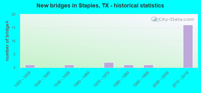
- New bridges - historical statistics
- 11930-1939
- 11950-1959
- 21970-1979
- 11980-1989
- 11990-1999
- 162010-2019
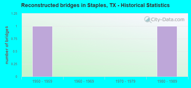
- Reconstructed bridges - Historical Statistics
- 11950-1959
- 01960-1969
- 01970-1979
- 11980-1989
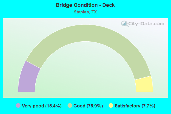
- Bridge Condition - Deck
- 15.4%Very good
- 76.9%Good
- 7.7%Satisfactory
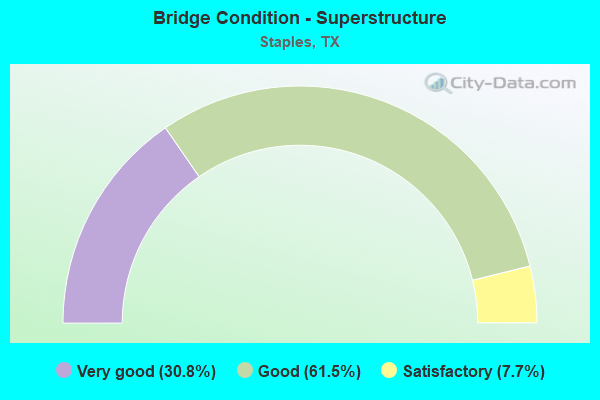
- Bridge Condition - Superstructure
- 30.8%Very good
- 61.5%Good
- 7.7%Satisfactory
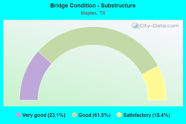
- Bridge Condition - Substructure
- 23.1%Very good
- 61.5%Good
- 15.4%Satisfactory
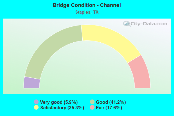
- Bridge Condition - Channel
- 5.9%Very good
- 41.2%Good
- 35.3%Satisfactory
- 17.6%Fair
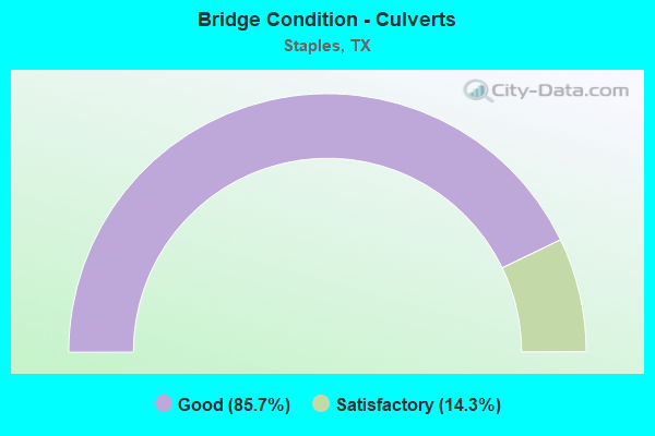
- Bridge Condition - Culverts
- 85.7%Good
- 14.3%Satisfactory
Find on map >> Show street view
Structure Number: 140280011502018, Location: 0.6 MI SW OF SH 80 (Lat: 29.752725, Lng: -97.780822), Route carried "on" structure: State highway 20, Year Built: 1957, Year Reconstructed: 1991, Status: Open, Structure Length: 6.86m (22.51ft), Average Daily Traffic: 775 (year 2020), Truck Traffic: 11%, Average Future Daily Traffic: 1,240 (year 2033), Design Load: H 15, Features Intersected: SAN MARCOS RIVER
Minimum Vertical Clearance: 30+ m (98+ ft), Kilometerpoint: 0.000, Lanes on structure: 2, Owner: State Highway Agency, Approaching Roadway Width: 6.7m (22.0ft), Skew: 3 degrees, Material/Design: Concrete, Design/Construction: Slab, Number Of Spans In Main Unit: 9, Length of Maximum Span: 7.6m (24.9ft), Curb-To-Curb Width: 11.6m (38.1ft), Out-to-Out Width: 12.2m (40.0ft)
Condition: Deck: Satisfactory, Superstructure: Satisfactory, Substructure: Satisfactory, Channel: Fair, Operating Rating: 42.6 metric tons, Method Used To Determine Operating Rating: Load Factor (LF), Inventory Rating: 25.4 metric tons, Method Used To Determine Inventory Rating: Load Factor (LF), Structural Evaluation: Equal to present minimum criteria, Deck Geometry: Better than present minimum criteria, Waterway Adequacy: High priority of replacement, Approach Roadway Alignment: Equal to present desirable criteria, Designated Inspection Frequency: Every 24 months, Underwater Inspection Frequency: Every 60 months, Inspection Date: January 2021, Underwater Inspection Date: May 2018, Deck Structure Type: Concrete Cast-file-Place, Wearing Surface/Protective System: Wearing Surface: Bituminous
Find on map >> Show street view
Structure Number: 140280011502019, Location: 0.6 MI NE OF SH 80 (Lat: 29.763972, Lng: -97.765911), Route carried "on" structure: State highway 20, Year Built: 1990, Status: Open, Structure Length: 3.66m (12.01ft), Average Daily Traffic: 1,358 (year 2019), Truck Traffic: 10%, Average Future Daily Traffic: 1,540 (year 2033), Design Load: HS 20, Features Intersected: CALLAHAN CREEK
Minimum Vertical Clearance: 30+ m (98+ ft), Kilometerpoint: 1.941, Lanes on structure: 2, Owner: State Highway Agency, Approaching Roadway Width: 8.5m (27.9ft), Material/Design: Concrete, Design/Construction: Stringer/Multi-beam, Number Of Spans In Main Unit: 3, Length of Maximum Span: 12.2m (40.0ft), Curb-To-Curb Width: 11.6m (38.1ft), Out-to-Out Width: 12.2m (40.0ft)
Condition: Deck: Good, Superstructure: Good, Substructure: Good, Channel: Satisfactory, Operating Rating: 68.0 metric tons, Method Used To Determine Operating Rating: Load Factor (LF), Inventory Rating: 40.8 metric tons, Method Used To Determine Inventory Rating: Load Factor (LF), Structural Evaluation: Better than present minimum criteria, Deck Geometry: Equal to present minimum criteria, Waterway Adequacy: Equal to present minimum criteria, Approach Roadway Alignment: Equal to present desirable criteria, Designated Inspection Frequency: Every 24 months, Inspection Date: January 2021, Deck Structure Type: Concrete Cast-file-Place, Wearing Surface/Protective System: Wearing Surface: Bituminous
Find on map >> Show street view
Structure Number: 140280028602127, Location: 2.10 MI NW OF FM 20 (Lat: 29.784722, Lng: -97.788089), Route carried "on" structure: State highway 80, Year Built: 2012, Status: Open, Structure Length: 15.00m (49.21ft), Average Daily Traffic: 5,242 (year 2020), Truck Traffic: 8%, Average Future Daily Traffic: 11,550 (year 2033), Design Load: HL 93, Features Intersected: SH 130 ML
Minimum Vertical Clearance: 30+ m (98+ ft), Kilometerpoint: 126.940, Lanes on structure: 3, Lanes under structure: 4, Owner: State Highway Agency, Maintenance Responsibility: State Toll Authority, Approaching Roadway Width: 20.7m (67.9ft), Skew: 4 degrees, Material/Design: Prestressed concrete, Design/Construction: Stringer/Multi-beam, Number Of Spans In Main Unit: 2, Number Of Approach Spans: 3, Length of Maximum Span: 40.8m (133.9ft), Curb-To-Curb Width: 20.7m (67.9ft), Out-to-Out Width: 21.3m (69.9ft)
Condition: Deck: Good, Superstructure: Good, Substructure: Good, Operating Rating: 54.4 metric tons, Method Used To Determine Operating Rating: Assigned ratings based on Load and Resistance Factor Design (LRFD) reported in metric tons, Inventory Rating: 32.7 metric tons, Method Used To Determine Inventory Rating: Assigned ratings based on Load and Resistance Factor Design (LRFD) reported in metric tons, Structural Evaluation: Better than present minimum criteria, Deck Geometry: Superior to present desirable criteria, Underclear: Equal to present desirable criteria, Approach Roadway Alignment: Equal to present desirable criteria, Designated Inspection Frequency: Every 24 months, Inspection Date: September 2021, Deck Structure Type: Concrete Precast Panels
Find on map >> Show street view
Structure Number: 140280028603009, Location: 8.6 MI S OF SH 142 (Lat: 29.745064, Lng: -97.763181), Route carried "on" structure: State highway 80, Year Built: 1935, Year Reconstructed: 1959, Status: Open, Structure Length: 2.62m (8.60ft), Average Daily Traffic: 5,213 (year 2020), Truck Traffic: 8%, Average Future Daily Traffic: 10,830 (year 2033), Features Intersected: CALLAHAN CREEK
Minimum Vertical Clearance: 30+ m (98+ ft), Kilometerpoint: 1.764, Lanes on structure: 2, Owner: State Highway Agency, Approaching Roadway Width: 13.4m (44.0ft), Material/Design: Concrete, Design/Construction: Tee Beam, Number Of Spans In Main Unit: 3, Length of Maximum Span: 8.5m (27.9ft), Curb-To-Curb Width: 13.4m (44.0ft), Out-to-Out Width: 14.0m (45.9ft)
Condition: Deck: Good, Superstructure: Good, Substructure: Satisfactory, Channel: Satisfactory, Operating Rating: 45.4 metric tons, Method Used To Determine Operating Rating: Load Factor (LF), Inventory Rating: 27.2 metric tons, Method Used To Determine Inventory Rating: Load Factor (LF), Structural Evaluation: Equal to present minimum criteria, Deck Geometry: Equal to present minimum criteria, Waterway Adequacy: Equal to present minimum criteria, Approach Roadway Alignment: Equal to present desirable criteria, Designated Inspection Frequency: Every 24 months, Inspection Date: January 2021, Deck Structure Type: Concrete Cast-file-Place, Wearing Surface/Protective System: Wearing Surface: Bituminous
Find on map >> Show street view
Structure Number: 140280143403007, Location: 0.3 MI NE OF FM 621 (Lat: 29.783081, Lng: -97.831381), Route carried "on" structure: State highway 1977, Year Built: 2014, Status: Open, Structure Length: 6.10m (20.01ft), Average Daily Traffic: 514 (year 2019), Truck Traffic: 13%, Average Future Daily Traffic: 670 (year 2030), Design Load: HL 93, Features Intersected: SAN MARCOS RIVER
Minimum Vertical Clearance: 30+ m (98+ ft), Kilometerpoint: 0.515, Lanes on structure: 2, Owner: State Highway Agency, Approaching Roadway Width: 9.8m (32.2ft), Skew: 1 degrees, Material/Design: Prestressed concrete, Number Of Spans In Main Unit: 4, Length of Maximum Span: 15.2m (49.9ft), Curb or Sidewalk Widths: Left: 1.5m (4.9ft), Right: 0.0m, Curb-To-Curb Width: 9.4m (30.8ft), Out-to-Out Width: 12.3m (40.4ft)
Condition: Deck: Good, Superstructure: Good, Substructure: Good, Channel: Fair, Operating Rating: 44.4 metric tons, Method Used To Determine Operating Rating: Assigned ratings based on Load and Resistance Factor Design (LRFD) reported in metric tons, Inventory Rating: 32.7 metric tons, Method Used To Determine Inventory Rating: Assigned ratings based on Load and Resistance Factor Design (LRFD) reported in metric tons, Structural Evaluation: Better than present minimum criteria, Deck Geometry: Equal to present minimum criteria, Waterway Adequacy: Better than present minimum criteria, Approach Roadway Alignment: Equal to present desirable criteria, Designated Inspection Frequency: Every 24 months, Underwater Inspection Frequency: Every 60 months, Inspection Date: January 2021, Underwater Inspection Date: Febuary 2021, Deck Structure Type: Concrete Precast Panels, Wearing Surface/Protective System: Wearing Surface: Monolithic Concrete
Find on map >> Show street view
Structure Number: 140280358301013, Location: 0.55 MI SW OF SH 80 (Lat: 29.774919, Lng: -97.795403), Route carried "on" structure: Other road 130, Year Built: 2011, Status: Open, Structure Length: 12.80m (41.99ft), Average Daily Traffic: 11,636 (year 2010), Truck Traffic: 15%, Average Future Daily Traffic: 29,254 (year 2030), Design Load: HL 93, Features Intersected: DICKERSON BRANCH
Minimum Vertical Clearance: 30+ m (98+ ft), Kilometerpoint: 127.470, Lanes on structure: 2, Toll: On toll road, Owner: State Highway Agency, Maintenance Responsibility: State Toll Authority, Approaching Roadway Width: 12.2m (40.0ft), Skew: 2 degrees, Material/Design: Prestressed concrete, Design/Construction: Stringer/Multi-beam, Number Of Spans In Main Unit: 4, Length of Maximum Span: 36.6m (120.1ft), Curb-To-Curb Width: 11.9m (39.0ft), Out-to-Out Width: 12.8m (42.0ft)
Condition: Deck: Good, Superstructure: Very good, Substructure: Good, Channel: Satisfactory, Operating Rating: 54.4 metric tons, Method Used To Determine Operating Rating: Assigned ratings based on Load and Resistance Factor Design (LRFD) reported in metric tons, Inventory Rating: 32.7 metric tons, Method Used To Determine Inventory Rating: Assigned ratings based on Load and Resistance Factor Design (LRFD) reported in metric tons, Structural Evaluation: Better than present minimum criteria, Deck Geometry: Better than present minimum criteria, Waterway Adequacy: Superior to present desirable criteria, Approach Roadway Alignment: Equal to present desirable criteria, Designated Inspection Frequency: Every 24 months, Inspection Date: September 2021, Deck Structure Type: Concrete Precast Panels
Find on map >> Show street view
Structure Number: 140280358301014, Location: 0.55 MI SW OF SH 80 (Lat: 29.776189, Lng: -97.794631), Route carried "on" structure: Other road 130, Year Built: 2011, Status: Open, Structure Length: 12.80m (41.99ft), Average Daily Traffic: 11,119 (year 2010), Truck Traffic: 15%, Average Future Daily Traffic: 27,908 (year 2030), Design Load: HL 93, Features Intersected: DICKERSON BRANCH
Minimum Vertical Clearance: 30+ m (98+ ft), Kilometerpoint: 127.470, Lanes on structure: 2, Toll: On toll road, Owner: State Highway Agency, Maintenance Responsibility: State Toll Authority, Approaching Roadway Width: 12.2m (40.0ft), Skew: 2 degrees, Material/Design: Prestressed concrete, Design/Construction: Stringer/Multi-beam, Number Of Spans In Main Unit: 4, Length of Maximum Span: 36.6m (120.1ft), Curb-To-Curb Width: 11.9m (39.0ft), Out-to-Out Width: 12.8m (42.0ft)
Condition: Deck: Good, Superstructure: Very good, Substructure: Good, Channel: Good, Operating Rating: 54.4 metric tons, Method Used To Determine Operating Rating: Assigned ratings based on Load and Resistance Factor Design (LRFD) reported in metric tons, Inventory Rating: 32.7 metric tons, Method Used To Determine Inventory Rating: Assigned ratings based on Load and Resistance Factor Design (LRFD) reported in metric tons, Structural Evaluation: Better than present minimum criteria, Deck Geometry: Better than present minimum criteria, Waterway Adequacy: Superior to present desirable criteria, Approach Roadway Alignment: Equal to present desirable criteria, Designated Inspection Frequency: Every 24 months, Inspection Date: September 2021, Deck Structure Type: Concrete Precast Panels
Find on map >> Show street view
Structure Number: 140280358301073, Location: 1.4 MI SW OF SH 80 (Lat: 29.767411, Lng: -97.806133), Route carried "on" structure: Other road 130, Year Built: 2011, Status: Open, Structure Length: 37.80m (124.02ft), Average Daily Traffic: 15,793 (year 2010), Truck Traffic: 15%, Average Future Daily Traffic: 40,695 (year 2030), Design Load: HL 93, Features Intersected: SAN MARCOS RIVER
Minimum Vertical Clearance: 30+ m (98+ ft), Kilometerpoint: 128.559, Lanes on structure: 2, Toll: On toll road, Owner: State Highway Agency, Maintenance Responsibility: State Toll Authority, Approaching Roadway Width: 12.2m (40.0ft), Skew: 1 degrees, Material/Design: Prestressed concrete, Design/Construction: Stringer/Multi-beam, Number Of Spans In Main Unit: 11, Length of Maximum Span: 39.6m (129.9ft), Curb-To-Curb Width: 11.9m (39.0ft), Out-to-Out Width: 12.8m (42.0ft)
Condition: Deck: Good, Superstructure: Very good, Substructure: Good, Channel: Satisfactory, Operating Rating: 54.4 metric tons, Method Used To Determine Operating Rating: Assigned ratings based on Load and Resistance Factor Design (LRFD) reported in metric tons, Inventory Rating: 32.7 metric tons, Method Used To Determine Inventory Rating: Assigned ratings based on Load and Resistance Factor Design (LRFD) reported in metric tons, Structural Evaluation: Better than present minimum criteria, Deck Geometry: Better than present minimum criteria, Waterway Adequacy: Superior to present desirable criteria, Approach Roadway Alignment: Equal to present desirable criteria, Designated Inspection Frequency: Every 24 months, Inspection Date: September 2021, Deck Structure Type: Concrete Precast Panels
Find on map >> Show street view
Structure Number: 140280358301074, Location: 1.4 MI SW OF SH 80 (Lat: 29.769878, Lng: -97.803644), Route carried "on" structure: Other road 130, Year Built: 2011, Status: Open, Structure Length: 37.83m (124.11ft), Average Daily Traffic: 15,793 (year 2010), Truck Traffic: 15%, Average Future Daily Traffic: 40,695 (year 2030), Design Load: HL 93, Features Intersected: SAN MARCOS RIVER
Minimum Vertical Clearance: 30+ m (98+ ft), Kilometerpoint: 128.570, Lanes on structure: 2, Toll: On toll road, Owner: State Highway Agency, Maintenance Responsibility: State Toll Authority, Approaching Roadway Width: 12.2m (40.0ft), Skew: 1 degrees, Material/Design: Prestressed concrete, Design/Construction: Stringer/Multi-beam, Number Of Spans In Main Unit: 11, Length of Maximum Span: 40.8m (133.9ft), Curb-To-Curb Width: 11.9m (39.0ft), Out-to-Out Width: 12.8m (42.0ft)
Condition: Deck: Good, Superstructure: Good, Substructure: Good, Channel: Satisfactory, Operating Rating: 54.4 metric tons, Method Used To Determine Operating Rating: Assigned ratings based on Load and Resistance Factor Design (LRFD) reported in metric tons, Inventory Rating: 32.7 metric tons, Method Used To Determine Inventory Rating: Assigned ratings based on Load and Resistance Factor Design (LRFD) reported in metric tons, Structural Evaluation: Better than present minimum criteria, Deck Geometry: Better than present minimum criteria, Waterway Adequacy: Superior to present desirable criteria, Approach Roadway Alignment: Equal to present desirable criteria, Designated Inspection Frequency: Every 24 months, Inspection Date: September 2021, Deck Structure Type: Concrete Precast Panels
Find on map >> Show street view
Structure Number: 150950098701009, Location: 0.70 MI W OF FM 621 (Lat: 29.734731, Lng: -97.822411), Route carried "on" structure: State highway 20, Year Built: 1988, Status: Open, Structure Length: 2.62m (8.60ft), Average Daily Traffic: 490 (year 2020), Truck Traffic: 14%, Average Future Daily Traffic: 810 (year 2033), Design Load: HS 20, Features Intersected: LITTLE COTTONWOOD CK
Minimum Vertical Clearance: 30+ m (98+ ft), Kilometerpoint: 52.931, Lanes on structure: 2, Owner: State Highway Agency, Approaching Roadway Width: 11.0m (36.1ft), Skew: 3 degrees, Material/Design: Concrete, Design/Construction: Culvert, Number Of Spans In Main Unit: 7, Length of Maximum Span: 3.0m (9.8ft), Curb-To-Curb Width: 11.0m (36.1ft), Out-to-Out Width: 12.2m (40.0ft)
Condition: Channel: Fair, Culverts: Satisfactory, Operating Rating: 32.7 metric tons, Method Used To Determine Operating Rating: Field evaluation and documented engineering judgment, Inventory Rating: 24.5 metric tons, Method Used To Determine Inventory Rating: Field evaluation and documented engineering judgment, Structural Evaluation: Equal to present minimum criteria, Deck Geometry: Better than present minimum criteria, Waterway Adequacy: Equal to present minimum criteria, Approach Roadway Alignment: Equal to present desirable criteria, Designated Inspection Frequency: Every 24 months, Inspection Date: September 2020, Deck Structure Type: Concrete Cast-file-Place, Wearing Surface/Protective System: Wearing Surface: Bituminous
Find on map >> Show street view
Structure Number: 150950143401005, Location: 8.07 MI E SH 123 (Lat: 29.779008, Lng: -97.854167), Route carried "on" structure: State highway 1339, Year Built: 1971, Status: Open, Structure Length: 0.94m (3.08ft), Average Daily Traffic: 371 (year 2020), Truck Traffic: 4%, Average Future Daily Traffic: 340 (year 2033), Design Load: HS 20, Features Intersected: DRAW
Minimum Vertical Clearance: 30+ m (98+ ft), Kilometerpoint: 12.991, Lanes on structure: 2, Owner: State Highway Agency, Approaching Roadway Width: 7.6m (24.9ft), Skew: 4 degrees, Material/Design: Concrete, Design/Construction: Culvert, Number Of Spans In Main Unit: 4, Length of Maximum Span: 1.5m (4.9ft), Curb-To-Curb Width: 8.5m (27.9ft), Out-to-Out Width: 9.8m (32.2ft)
Condition: Channel: Good, Culverts: Good, Operating Rating: 39.9 metric tons, Method Used To Determine Operating Rating: Load Factor (LF), Inventory Rating: 23.6 metric tons, Method Used To Determine Inventory Rating: Load Factor (LF), Structural Evaluation: Equal to present minimum criteria, Deck Geometry: Equal to present minimum criteria, Waterway Adequacy: Equal to present minimum criteria, Approach Roadway Alignment: Equal to present desirable criteria, Designated Inspection Frequency: Every 24 months, Inspection Date: September 2020, Deck Structure Type: Concrete Cast-file-Place, Wearing Surface/Protective System: Wearing Surface: Bituminous
Find on map >> Show street view
Structure Number: 150950143401006, Location: 8.5 MI EAST SH 123 (Lat: 29.782892, Lng: -97.848994), Route carried "on" structure: State highway 1339, Year Built: 1971, Status: Open, Structure Length: 0.67m (2.20ft), Average Daily Traffic: 371 (year 2020), Truck Traffic: 4%, Average Future Daily Traffic: 340 (year 2033), Design Load: HS 20, Features Intersected: DRAW
Minimum Vertical Clearance: 30+ m (98+ ft), Kilometerpoint: 13.667, Lanes on structure: 2, Owner: State Highway Agency, Approaching Roadway Width: 7.0m (23.0ft), Skew: 1 degrees, Material/Design: Concrete, Design/Construction: Culvert, Number Of Spans In Main Unit: 4, Length of Maximum Span: 1.5m (4.9ft), Curb-To-Curb Width: 8.8m (28.9ft), Out-to-Out Width: 10.1m (33.1ft)
Condition: Channel: Satisfactory, Culverts: Good, Operating Rating: 39.9 metric tons, Method Used To Determine Operating Rating: Load Factor (LF), Inventory Rating: 23.6 metric tons, Method Used To Determine Inventory Rating: Load Factor (LF), Structural Evaluation: Equal to present minimum criteria, Deck Geometry: Equal to present minimum criteria, Waterway Adequacy: Better than present minimum criteria, Approach Roadway Alignment: Equal to present desirable criteria, Designated Inspection Frequency: Every 24 months, Inspection Date: September 2020, Deck Structure Type: Concrete Cast-file-Place, Wearing Surface/Protective System: Wearing Surface: Bituminous
Find on map >> Show street view
Structure Number: 150950358302015, Location: 3.0 MI SW of Caldwell CL (Lat: 29.741322, Lng: -97.847617), Route carried "on" structure: Other road 130, Year Built: 2012, Status: Open, Structure Length: 0.79m (2.59ft), Average Daily Traffic: 15,793 (year 2014), Truck Traffic: 15%, Average Future Daily Traffic: 40,695 (year 2034), Design Load: HS 20, Features Intersected: Draw
Minimum Vertical Clearance: 30+ m (98+ ft), Kilometerpoint: 0.000, Lanes on structure: 2, Toll: On toll road, Owner: State Highway Agency, Maintenance Responsibility: State Toll Authority, Approaching Roadway Width: 12.2m (40.0ft), Material/Design: Concrete, Design/Construction: Culvert, Number Of Spans In Main Unit: 3, Length of Maximum Span: 2.1m (6.9ft)
Condition: Channel: Very good, Culverts: Good, Operating Rating: 54.4 metric tons, Method Used To Determine Operating Rating: Assigned rating based on Load Factor Design (LFD) reported in metric tons, Inventory Rating: 32.7 metric tons, Method Used To Determine Inventory Rating: Assigned rating based on Load Factor Design (LFD) reported in metric tons, Structural Evaluation: Better than present minimum criteria, Waterway Adequacy: Superior to present desirable criteria, Approach Roadway Alignment: Equal to present desirable criteria, Designated Inspection Frequency: Every 24 months, Inspection Date: August 2020
Find on map >> Show street view
Structure Number: 150950358302016, Location: 3.0 MI SW of Caldwell CL (Lat: 29.742003, Lng: -97.847725), Route carried "on" structure: Other road 130, Year Built: 2012, Status: Open, Structure Length: 0.79m (2.59ft), Average Daily Traffic: 15,793 (year 2014), Truck Traffic: 15%, Average Future Daily Traffic: 40,693 (year 2034), Design Load: HS 20, Features Intersected: Draw
Minimum Vertical Clearance: 30+ m (98+ ft), Kilometerpoint: 0.000, Lanes on structure: 2, Toll: On toll road, Owner: State Highway Agency, Maintenance Responsibility: State Toll Authority, Approaching Roadway Width: 12.2m (40.0ft), Material/Design: Concrete, Design/Construction: Culvert, Number Of Spans In Main Unit: 3, Length of Maximum Span: 2.1m (6.9ft)
Condition: Channel: Good, Culverts: Good, Operating Rating: 54.4 metric tons, Method Used To Determine Operating Rating: Assigned rating based on Load Factor Design (LFD) reported in metric tons, Inventory Rating: 32.7 metric tons, Method Used To Determine Inventory Rating: Assigned rating based on Load Factor Design (LFD) reported in metric tons, Structural Evaluation: Better than present minimum criteria, Waterway Adequacy: Superior to present desirable criteria, Approach Roadway Alignment: Equal to present desirable criteria, Designated Inspection Frequency: Every 24 months, Inspection Date: August 2020
Find on map >> Show street view
Structure Number: 150950358302017, Location: 4.0 MI SW of Caldwell CL (Lat: 29.733978, Lng: -97.861244), Route carried "on" structure: Other road 130, Year Built: 2012, Status: Open, Structure Length: 1.95m (6.40ft), Average Daily Traffic: 15,793 (year 2014), Truck Traffic: 15%, Average Future Daily Traffic: 40,695 (year 2034), Design Load: HS 20, Features Intersected: Draw
Minimum Vertical Clearance: 30+ m (98+ ft), Kilometerpoint: 0.000, Lanes on structure: 2, Toll: On toll road, Owner: State Highway Agency, Maintenance Responsibility: State Toll Authority, Approaching Roadway Width: 12.2m (40.0ft), Skew: 2 degrees, Material/Design: Concrete, Design/Construction: Culvert, Number Of Spans In Main Unit: 5, Length of Maximum Span: 3.0m (9.8ft)
Condition: Channel: Good, Culverts: Good, Operating Rating: 54.4 metric tons, Method Used To Determine Operating Rating: Assigned rating based on Load Factor Design (LFD) reported in metric tons, Inventory Rating: 32.7 metric tons, Method Used To Determine Inventory Rating: Assigned rating based on Load Factor Design (LFD) reported in metric tons, Structural Evaluation: Better than present minimum criteria, Waterway Adequacy: Superior to present desirable criteria, Approach Roadway Alignment: Equal to present desirable criteria, Designated Inspection Frequency: Every 24 months, Inspection Date: August 2020
Find on map >> Show street view
Structure Number: 150950358302018, Location: 4.0 MI SW of Caldwell CL (Lat: 29.734825, Lng: -97.861392), Route carried "on" structure: Other road 130, Year Built: 2012, Status: Open, Structure Length: 1.95m (6.40ft), Average Daily Traffic: 15,793 (year 2014), Truck Traffic: 15%, Average Future Daily Traffic: 40,695 (year 2034), Design Load: HS 20, Features Intersected: Draw
Minimum Vertical Clearance: 30+ m (98+ ft), Kilometerpoint: 0.000, Lanes on structure: 2, Toll: On toll road, Owner: State Highway Agency, Maintenance Responsibility: State Toll Authority, Approaching Roadway Width: 12.2m (40.0ft), Skew: 2 degrees, Material/Design: Concrete, Design/Construction: Culvert, Number Of Spans In Main Unit: 5, Length of Maximum Span: 3.0m (9.8ft)
Condition: Channel: Good, Culverts: Good, Operating Rating: 54.4 metric tons, Method Used To Determine Operating Rating: Assigned rating based on Load Factor Design (LFD) reported in metric tons, Inventory Rating: 32.7 metric tons, Method Used To Determine Inventory Rating: Assigned rating based on Load Factor Design (LFD) reported in metric tons, Structural Evaluation: Better than present minimum criteria, Waterway Adequacy: Superior to present desirable criteria, Approach Roadway Alignment: Equal to present desirable criteria, Designated Inspection Frequency: Every 24 months, Inspection Date: August 2020
Find on map >> Show street view
Structure Number: 150950358302023, Location: 1.1 MI SW OF CALDWELL CL (Lat: 29.757078, Lng: -97.820514), Route carried "on" structure: State highway 621, Year Built: 2012, Status: Open, Structure Length: 12.41m (40.72ft), Average Daily Traffic: 650 (year 2013), Truck Traffic: 23%, Average Future Daily Traffic: 910 (year 2033), Design Load: HL 93, Features Intersected: SH 130
Minimum Vertical Clearance: 30+ m (98+ ft), Kilometerpoint: 55.989, Lanes on structure: 2, Lanes under structure: 4, Owner: State Highway Agency, Maintenance Responsibility: State Toll Authority, Approaching Roadway Width: 7.9m (25.9ft), Skew: 2 degrees, Material/Design: Prestressed concrete, Design/Construction: Stringer/Multi-beam, Number Of Spans In Main Unit: 2, Number Of Approach Spans: 3, Length of Maximum Span: 33.2m (108.9ft), Curb-To-Curb Width: 12.2m (40.0ft), Out-to-Out Width: 12.8m (42.0ft)
Condition: Deck: Good, Superstructure: Good, Substructure: Good, Operating Rating: 54.4 metric tons, Method Used To Determine Operating Rating: Assigned ratings based on Load and Resistance Factor Design (LRFD) reported in metric tons, Inventory Rating: 32.7 metric tons, Method Used To Determine Inventory Rating: Assigned ratings based on Load and Resistance Factor Design (LRFD) reported in metric tons, Structural Evaluation: Better than present minimum criteria, Deck Geometry: Equal to present desirable criteria, Underclear: Equal to present desirable criteria, Approach Roadway Alignment: Equal to present desirable criteria, Designated Inspection Frequency: Every 24 months, Inspection Date: August 2020, Deck Structure Type: Concrete Precast Panels
Find on map >> Show street view
Structure Number: 150950358302024, Location: 1.9 MI SW OF CALDWELL CL (Lat: 29.749256, Lng: -97.832000), Route carried "on" structure: Other road 130, Year Built: 2012, Status: Open, Structure Length: 8.53m (27.99ft), Average Daily Traffic: 15,793 (year 2014), Truck Traffic: 15%, Average Future Daily Traffic: 40,695 (year 2034), Design Load: HL 93, Features Intersected: YORK CREEK TRIBUTARY #4
Minimum Vertical Clearance: 30+ m (98+ ft), Kilometerpoint: 0.000, Lanes on structure: 2, Toll: On toll road, Owner: State Highway Agency, Maintenance Responsibility: State Toll Authority, Approaching Roadway Width: 12.2m (40.0ft), Material/Design: Prestressed concrete, Design/Construction: Stringer/Multi-beam, Number Of Spans In Main Unit: 1, Number Of Approach Spans: 2, Length of Maximum Span: 36.6m (120.1ft), Curb-To-Curb Width: 12.2m (40.0ft), Out-to-Out Width: 12.8m (42.0ft)
Condition: Deck: Good, Superstructure: Good, Substructure: Very good, Channel: Good, Operating Rating: 54.4 metric tons, Method Used To Determine Operating Rating: Assigned ratings based on Load and Resistance Factor Design (LRFD) reported in metric tons, Inventory Rating: 32.7 metric tons, Method Used To Determine Inventory Rating: Assigned ratings based on Load and Resistance Factor Design (LRFD) reported in metric tons, Structural Evaluation: Better than present minimum criteria, Deck Geometry: Better than present minimum criteria, Waterway Adequacy: Superior to present desirable criteria, Approach Roadway Alignment: Equal to present desirable criteria, Designated Inspection Frequency: Every 24 months, Inspection Date: August 2020, Deck Structure Type: Concrete Precast Panels
Find on map >> Show street view
Structure Number: 150950358302025, Location: 1.9 MI SW OF CALDWELL CL (Lat: 29.750064, Lng: -97.831883), Route carried "on" structure: Other road 130, Year Built: 2011, Status: Open, Structure Length: 8.53m (27.99ft), Average Daily Traffic: 15,793 (year 2010), Truck Traffic: 15%, Average Future Daily Traffic: 40,695 (year 2030), Design Load: HL 93, Features Intersected: YORK CREEK TRIBUTARY #4
Minimum Vertical Clearance: 30+ m (98+ ft), Kilometerpoint: 0.000, Lanes on structure: 2, Toll: On toll road, Owner: State Highway Agency, Maintenance Responsibility: State Toll Authority, Approaching Roadway Width: 12.2m (40.0ft), Material/Design: Prestressed concrete, Design/Construction: Stringer/Multi-beam, Number Of Spans In Main Unit: 1, Number Of Approach Spans: 2, Length of Maximum Span: 36.6m (120.1ft), Curb-To-Curb Width: 12.2m (40.0ft), Out-to-Out Width: 12.8m (42.0ft)
Condition: Deck: Very good, Superstructure: Good, Substructure: Very good, Channel: Good, Operating Rating: 54.4 metric tons, Method Used To Determine Operating Rating: Assigned ratings based on Load and Resistance Factor Design (LRFD) reported in metric tons, Inventory Rating: 32.7 metric tons, Method Used To Determine Inventory Rating: Assigned ratings based on Load and Resistance Factor Design (LRFD) reported in metric tons, Structural Evaluation: Better than present minimum criteria, Deck Geometry: Better than present minimum criteria, Waterway Adequacy: Superior to present desirable criteria, Approach Roadway Alignment: Equal to present desirable criteria, Designated Inspection Frequency: Every 24 months, Inspection Date: August 2020, Deck Structure Type: Concrete Precast Panels
Find on map >> Show street view
Structure Number: 150950358302036, Location: 3.3 MI SW OF CALDWELL CL (Lat: 29.740744, Lng: -97.852806), Route carried "on" structure: County highway 242, Year Built: 2012, Status: Open, Structure Length: 11.77m (38.62ft), Average Daily Traffic: 52 (year 2010), Average Future Daily Traffic: 104 (year 2030), Design Load: HL 93, Features Intersected: SH 130
Minimum Vertical Clearance: 30+ m (98+ ft), Kilometerpoint: 0.000, Lanes on structure: 2, Lanes under structure: 4, Owner: State Highway Agency, Maintenance Responsibility: State Toll Authority, Approaching Roadway Width: 7.3m (24.0ft), Skew: 1 degrees, Material/Design: Prestressed concrete, Design/Construction: Stringer/Multi-beam, Number Of Spans In Main Unit: 2, Number Of Approach Spans: 3, Length of Maximum Span: 31.4m (103.0ft), Curb-To-Curb Width: 9.8m (32.2ft), Out-to-Out Width: 10.4m (34.1ft)
Condition: Deck: Very good, Superstructure: Very good, Substructure: Very good, Operating Rating: 54.4 metric tons, Method Used To Determine Operating Rating: Assigned ratings based on Load and Resistance Factor Design (LRFD) reported in metric tons, Inventory Rating: 32.7 metric tons, Method Used To Determine Inventory Rating: Assigned ratings based on Load and Resistance Factor Design (LRFD) reported in metric tons, Structural Evaluation: Equal to present desirable criteria, Deck Geometry: Equal to present desirable criteria, Underclear: Superior to present desirable criteria, Approach Roadway Alignment: Equal to present desirable criteria, Designated Inspection Frequency: Every 24 months, Inspection Date: August 2020, Deck Structure Type: Concrete Precast Panels
Find on map >> Show street view
Structure Number: 150950358302023, Location: 1.1 MI SW OF CALDWELL CL (Lat: 29.757078, Lng: -97.820514), Route carried "under" structure: Other road 130, Year Built: 2012, Structure Length: 0. m, Average Daily Traffic: 31,586 (year 2014), Truck Traffic: 15%, Features Intersected: SH 130, Facility Carried by Structure: FM 621
Minimum Vertical Clearance: 5.84m (19.16ft), Kilometerpoint: 0.000, Lanes on structure: 2, Lanes under structure: 4, Toll: On toll road, Material/Design: Prestressed concrete, Design/Construction: Stringer/Multi-beam, Length of Maximum Span: 33.2m (108.9ft)
Find on map >> Show street view
Structure Number: 150950358302036, Location: 3.3 MI SW OF CALDWELL CL (Lat: 29.740744, Lng: -97.852806), Route carried "under" structure: Other road 130, Year Built: 2012, Structure Length: 0. m, Average Daily Traffic: 31,586 (year 2014), Truck Traffic: 15%, Features Intersected: SH 130, Facility Carried by Structure: CR 242 (BYLERPOOL)
Minimum Vertical Clearance: 5.94m (19.49ft), Kilometerpoint: 0.000, Lanes on structure: 2, Lanes under structure: 4, Toll: On toll road, Material/Design: Prestressed concrete, Design/Construction: Stringer/Multi-beam, Length of Maximum Span: 31.4m (103.0ft)