Bridge Statistics for Stonewood, West Virginia (WV)
Condition, Traffic, Stress, Structural Evaluation, Project Costs
- National Bridge Inventory (NBI) Statistics
- 18Number of bridges
- 233ft / 70.6mTotal length
- $31,280,000Total costs
- 189,550Total average daily traffic
- 25,769Total average daily truck traffic
- National Bridge Inventory (NBI) Registered Bridges for Stonewood
- No street view available for this location
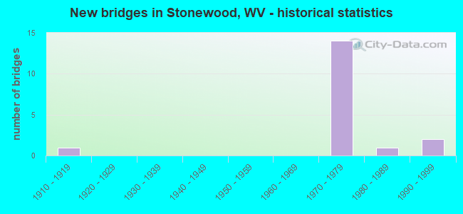
- New bridges - historical statistics
- 11910-1919
- 141970-1979
- 11980-1989
- 21990-1999
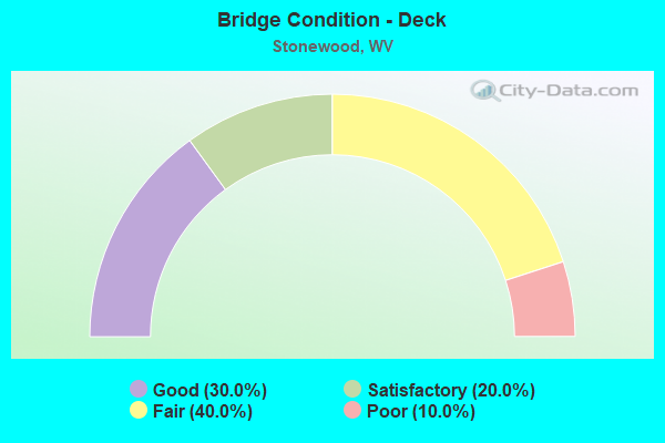
- Bridge Condition - Deck
- 30.0%Good
- 20.0%Satisfactory
- 40.0%Fair
- 10.0%Poor
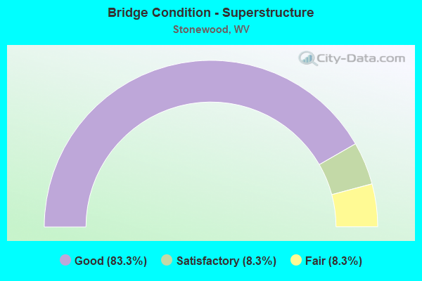
- Bridge Condition - Superstructure
- 83.3%Good
- 8.3%Satisfactory
- 8.3%Fair
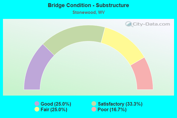
- Bridge Condition - Substructure
- 25.0%Good
- 33.3%Satisfactory
- 25.0%Fair
- 16.7%Poor
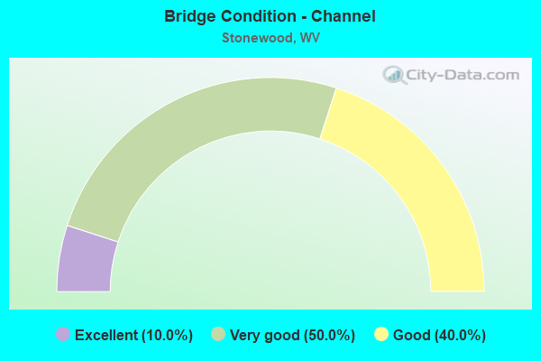
- Bridge Condition - Channel
- 10.0%Excellent
- 50.0%Very good
- 40.0%Good
Find on map >> Show street view
Structure Number: 17A1, Location: 0.11 MI SOUTH CO RT 42 (Lat: 39.227389, Lng: -80.298481), Route carried "on" structure: State highway 2000, Year Built: 1973, Status: Open, Structure Length: 7.24m (23.75ft), Average Daily Traffic: 11,900 (year 2019), Truck Traffic: 6%, Average Future Daily Traffic: 22,730 (year 2041), Design Load: HS 20, Features Intersected: ELK CREEK, Facility Carried by Structure: WV ROUTE 20
Minimum Vertical Clearance: 30+ m (98+ ft), Kilometerpoint: 14.050, Lanes on structure: 3, Owner: State Highway Agency, Approaching Roadway Width: 20.1m (65.9ft), Skew: 2 degrees, Material/Design: Steel continuous, Design/Construction: Stringer/Multi-beam, Number Of Spans In Main Unit: 1, Number Of Approach Spans: 2, Length of Maximum Span: 28.3m (92.8ft), Curb-To-Curb Width: 19.1m (62.7ft), Out-to-Out Width: 20.3m (66.6ft)
Condition: Deck: Satisfactory, Superstructure: Good, Substructure: Poor, Channel: Very good, Operating Rating: 58.0 metric tons, Method Used To Determine Operating Rating: Load Factor (LF), Inventory Rating: 34.5 metric tons, Method Used To Determine Inventory Rating: Load Factor (LF), Structural Evaluation: Meets minimum limits, Deck Geometry: Superior to present desirable criteria, Waterway Adequacy: Superior to present desirable criteria, Approach Roadway Alignment: Equal to present desirable criteria, Length Of Structure Improvement: 8.32m (27.30ft), Designated Inspection Frequency: Every 24 months, Inspection Date: September 2021, Bridge Improvement Cost: $857,000, Roadway Improvement Cost: $235,000, Total Project Cost: $1,228,000 ( Estimate for 2021), Deck Structure Type: Concrete Cast-file-Place, Wearing Surface/Protective System: Wearing Surface: Monolithic Concrete
Find on map >> Show street view
Structure Number: 17A174, Location: 0.03 MI EAST WV RT 20 (Lat: 39.228961, Lng: -80.298611), Route carried "on" structure: County highway 4200, Year Built: 1973, Status: Open, Structure Length: 7.90m (25.92ft), Average Daily Traffic: 500 (year 2018), Truck Traffic: 7%, Average Future Daily Traffic: 825 (year 2038), Design Load: HS 20, Features Intersected: ELK CREEK, Facility Carried by Structure: HARRISON CO RT 42
Minimum Vertical Clearance: 30+ m (98+ ft), Kilometerpoint: 0.048, Lanes on structure: 2, Owner: State Highway Agency, Approaching Roadway Width: 10.4m (34.1ft), Skew: 1 degrees, Material/Design: Steel continuous, Design/Construction: Stringer/Multi-beam, Number Of Spans In Main Unit: 1, Number Of Approach Spans: 2, Length of Maximum Span: 31.1m (102.0ft), Curb-To-Curb Width: 9.9m (32.5ft), Out-to-Out Width: 11.2m (36.7ft)
Condition: Deck: Good, Superstructure: Good, Substructure: Satisfactory, Channel: Excellent, Operating Rating: 55.3 metric tons, Method Used To Determine Operating Rating: Load Factor (LF), Inventory Rating: 33.6 metric tons, Method Used To Determine Inventory Rating: Load Factor (LF), Structural Evaluation: Equal to present minimum criteria, Deck Geometry: Equal to present minimum criteria, Waterway Adequacy: Superior to present desirable criteria, Approach Roadway Alignment: Better than present minimum criteria, Designated Inspection Frequency: Every 24 months, Inspection Date: May 2020, Deck Structure Type: Concrete Cast-file-Place, Wearing Surface/Protective System: Wearing Surface: Latex Concrete
Find on map >> Show street view
Structure Number: 17A175, Location: 0.69 MI WEST CO RT 23/1 (Lat: 39.231800, Lng: -80.288469), Route carried "on" structure: County highway 4200, Year Built: 1913, Status: Open, Structure Length: 1.32m (4.33ft), Average Daily Traffic: 500 (year 2018), Truck Traffic: 7%, Average Future Daily Traffic: 650 (year 2038), Features Intersected: BRUSHY FORK, Facility Carried by Structure: HARRISON CO RT 42
Minimum Vertical Clearance: 30+ m (98+ ft), Kilometerpoint: 1.706, Lanes on structure: 2, Owner: State Highway Agency, Approaching Roadway Width: 6.4m (21.0ft), Material/Design: Concrete, Design/Construction: Arch - Deck, Number Of Spans In Main Unit: 1, Length of Maximum Span: 13.2m (43.3ft), Curb-To-Curb Width: 5.1m (16.7ft), Out-to-Out Width: 5.4m (17.7ft)
Condition: Superstructure: Fair, Substructure: Good, Channel: Good, Operating Rating: 47.2 metric tons, Method Used To Determine Operating Rating: Field evaluation and documented engineering judgment, Inventory Rating: 21.8 metric tons, Method Used To Determine Inventory Rating: Field evaluation and documented engineering judgment, Structural Evaluation: Somewhat better than minimum adequacy, Deck Geometry: High priority of replacement, Waterway Adequacy: Superior to present desirable criteria, Approach Roadway Alignment: Meets minimum limits, Length Of Structure Improvement: 1.43m (4.69ft), Designated Inspection Frequency: Every 24 months, Inspection Date: October 2020, Bridge Improvement Cost: $296,000, Roadway Improvement Cost: $251,000, Total Project Cost: $643,000 ( Estimate for 2020)
Find on map >> Show street view
Structure Number: 17A225, Location: 0.01 MI EAST WV RT 20 (Lat: 39.251869, Lng: -80.318600), Route carried "on" structure: State highway 5800, Year Built: 1983, Year Reconstructed: 1986, Status: Open, Structure Length: 5.09m (16.70ft), Average Daily Traffic: 9,100 (year 2018), Truck Traffic: 4%, Average Future Daily Traffic: 11,925 (year 2038), Design Load: HS 20, Features Intersected: ELK CREEK, Facility Carried by Structure: WV ROUTE 58
Minimum Vertical Clearance: 30+ m (98+ ft), Kilometerpoint: 0.016, Lanes on structure: 2, Owner: State Highway Agency, Approaching Roadway Width: 13.4m (44.0ft), Material/Design: Prestressed concrete, Design/Construction: Box Beam or Girders - Multiple, Number Of Spans In Main Unit: 3, Length of Maximum Span: 16.2m (53.1ft), Curb or Sidewalk Widths: Left: 0.9m (3.0ft), Right: 0.9m (3.0ft), Curb-To-Curb Width: 8.7m (28.5ft), Out-to-Out Width: 11.1m (36.4ft)
Condition: Superstructure: Good, Substructure: Fair, Channel: Very good, Operating Rating: 80.7 metric tons, Method Used To Determine Operating Rating: Load Factor (LF), Inventory Rating: 49.0 metric tons, Method Used To Determine Inventory Rating: Load Factor (LF), Structural Evaluation: Somewhat better than minimum adequacy, Deck Geometry: High priority of replacement, Waterway Adequacy: Equal to present desirable criteria, Approach Roadway Alignment: Equal to present desirable criteria, Length Of Structure Improvement: 6.10m (20.01ft), Designated Inspection Frequency: Every 24 months, Inspection Date: December 2020, Bridge Improvement Cost: $988,000, Roadway Improvement Cost: $904,000, Total Project Cost: $1,915,000 ( Estimate for 2021), Deck Structure Type: Other, Wearing Surface/Protective System: Wearing Surface: Bituminous, Deck Protection: Epoxy Coated Reinforcing
Find on map >> Show street view
Structure Number: 17A248, Location: 1.17 MI SOUTH OF WV 20 F (Lat: 39.211231, Lng: -80.305450), Route carried "on" structure: Interstate 7900, Year Built: 1970, Status: Open, Structure Length: 0.85m (2.79ft), Average Daily Traffic: 33,700 (year 2019), Truck Traffic: 21%, Average Future Daily Traffic: 45,200 (year 2041), Design Load: HS 20, Features Intersected: Harr. Co. Rt. 20/17, Facility Carried by Structure: I-79 NB AND SB
Minimum Vertical Clearance: 30+ m (98+ ft), Kilometerpoint: 183.755, Lanes on structure: 4, Lanes under structure: 2, Base Highway Network: Yes, Owner: State Highway Agency, Approaching Roadway Width: 23.2m (76.1ft), Material/Design: Concrete, Design/Construction: Culvert, Number Of Spans In Main Unit: 1, Length of Maximum Span: 8.5m (27.9ft)
Condition: Culverts: Good, Operating Rating: 71.7 metric tons, Method Used To Determine Operating Rating: Field evaluation and documented engineering judgment, Inventory Rating: 32.7 metric tons, Method Used To Determine Inventory Rating: Field evaluation and documented engineering judgment, Structural Evaluation: Better than present minimum criteria, Underclear: High priority of replacement, Approach Roadway Alignment: Equal to present desirable criteria, Length Of Structure Improvement: 1.07m (3.51ft), Designated Inspection Frequency: Every 24 months, Inspection Date: March 2021, Bridge Improvement Cost: $914,000, Roadway Improvement Cost: $863,000, Total Project Cost: $21,081,000 ( Estimate for 2019)
Find on map >> Show street view
Structure Number: 17A249, Location: 0.43 MI SOUTH WV RT 20 (Lat: 39.221481, Lng: -80.301689), Route carried "on" structure: Interstate 7900, Year Built: 1970, Status: Open, Structure Length: 8.95m (29.36ft), Average Daily Traffic: 17,600 (year 2018), Truck Traffic: 20%, Average Future Daily Traffic: 25,520 (year 2038), Design Load: HS 20, Features Intersected: ELK CREEK, Facility Carried by Structure: INTERSTATE 79 NB
Minimum Vertical Clearance: 30+ m (98+ ft), Kilometerpoint: 184.914, Lanes on structure: 2, Base Highway Network: Yes, Owner: State Highway Agency, Approaching Roadway Width: 11.6m (38.1ft), Skew: 3 degrees, Material/Design: Steel continuous, Design/Construction: Stringer/Multi-beam, Number Of Spans In Main Unit: 1, Number Of Approach Spans: 2, Length of Maximum Span: 33.8m (110.9ft), Curb-To-Curb Width: 12.3m (40.4ft), Out-to-Out Width: 13.6m (44.6ft)
Condition: Deck: Poor, Superstructure: Good, Substructure: Poor, Channel: Good, Operating Rating: 59.9 metric tons, Method Used To Determine Operating Rating: Load Factor (LF), Inventory Rating: 35.4 metric tons, Method Used To Determine Inventory Rating: Load Factor (LF), Structural Evaluation: Meets minimum limits, Deck Geometry: Better than present minimum criteria, Waterway Adequacy: Superior to present desirable criteria, Approach Roadway Alignment: Equal to present desirable criteria, Length Of Structure Improvement: 8.96m (29.40ft), Designated Inspection Frequency: Every 24 months, Inspection Date: January 2020, Bridge Improvement Cost: $704,000, Roadway Improvement Cost: $112,000, Total Project Cost: $1,124,000 ( Estimate for 2020), Deck Structure Type: Concrete Cast-file-Place, Wearing Surface/Protective System: Wearing Surface: Latex Concrete
Find on map >> Show street view
Structure Number: 17A25, Location: 0.43 MI SOUTH WV RT 20 (Lat: 39.221211, Lng: -80.301550), Route carried "on" structure: Interstate 7900, Year Built: 1970, Status: Open, Structure Length: 8.95m (29.36ft), Average Daily Traffic: 17,600 (year 2018), Truck Traffic: 20%, Average Future Daily Traffic: 25,520 (year 2038), Design Load: HS 20, Features Intersected: ELK CREEK, Facility Carried by Structure: INTERSTATE 79 SB
Minimum Vertical Clearance: 30+ m (98+ ft), Kilometerpoint: 184.914, Lanes on structure: 2, Base Highway Network: Yes, Owner: State Highway Agency, Approaching Roadway Width: 11.6m (38.1ft), Skew: 3 degrees, Material/Design: Steel continuous, Design/Construction: Stringer/Multi-beam, Number Of Spans In Main Unit: 1, Number Of Approach Spans: 2, Length of Maximum Span: 33.8m (110.9ft), Curb-To-Curb Width: 12.3m (40.4ft), Out-to-Out Width: 13.6m (44.6ft)
Condition: Deck: Fair, Superstructure: Good, Substructure: Fair, Channel: Good, Operating Rating: 59.9 metric tons, Method Used To Determine Operating Rating: Load Factor (LF), Inventory Rating: 35.4 metric tons, Method Used To Determine Inventory Rating: Load Factor (LF), Structural Evaluation: Somewhat better than minimum adequacy, Deck Geometry: Better than present minimum criteria, Waterway Adequacy: Superior to present desirable criteria, Approach Roadway Alignment: Equal to present desirable criteria, Length Of Structure Improvement: 8.96m (29.40ft), Designated Inspection Frequency: Every 24 months, Inspection Date: January 2020, Bridge Improvement Cost: $712,000, Roadway Improvement Cost: $114,000, Total Project Cost: $1,135,000 ( Estimate for 2020), Deck Structure Type: Concrete Cast-file-Place, Wearing Surface/Protective System: Wearing Surface: Latex Concrete
Find on map >> Show street view
Structure Number: 17A251, Location: 2.41 MI SOUTH WV RT 58 F (Lat: 39.226239, Lng: -80.297211), Route carried "on" structure: Interstate 7900, Year Built: 1973, Status: Open, Structure Length: 5.85m (19.19ft), Average Daily Traffic: 18,550 (year 2019), Truck Traffic: 13%, Average Future Daily Traffic: 23,745 (year 2041), Design Load: HS 20, Features Intersected: WV ROUTE 20, Facility Carried by Structure: INTERSTATE 79 NB
Minimum Vertical Clearance: 30+ m (98+ ft), Kilometerpoint: 185.606, Lanes on structure: 2, Lanes under structure: 3, Base Highway Network: Yes, Owner: State Highway Agency, Approaching Roadway Width: 11.6m (38.1ft), Skew: 3 degrees, Material/Design: Steel continuous, Design/Construction: Stringer/Multi-beam, Number Of Spans In Main Unit: 1, Number Of Approach Spans: 2, Length of Maximum Span: 25.9m (85.0ft), Curb-To-Curb Width: 12.3m (40.4ft), Out-to-Out Width: 13.6m (44.6ft)
Condition: Deck: Fair, Superstructure: Good, Substructure: Satisfactory, Operating Rating: 70.7 metric tons, Method Used To Determine Operating Rating: Load Factor (LF), Inventory Rating: 42.6 metric tons, Method Used To Determine Inventory Rating: Load Factor (LF), Structural Evaluation: Equal to present minimum criteria, Deck Geometry: Better than present minimum criteria, Underclear: Somewhat better than minimum adequacy, Approach Roadway Alignment: Better than present minimum criteria, Length Of Structure Improvement: 5.85m (19.19ft), Designated Inspection Frequency: Every 24 months, Inspection Date: December 2021, Bridge Improvement Cost: $698,000, Roadway Improvement Cost: $129,000, Total Project Cost: $1,099,000 ( Estimate for 2022), Deck Structure Type: Concrete Cast-file-Place, Wearing Surface/Protective System: Wearing Surface: Latex Concrete
Find on map >> Show street view
Structure Number: 17A252, Location: 2.41 MI SOUTH WV RTE 58 F (Lat: 39.226019, Lng: -80.296911), Route carried "on" structure: Interstate 7900, Year Built: 1973, Status: Open, Structure Length: 5.85m (19.19ft), Average Daily Traffic: 16,850 (year 2019), Truck Traffic: 13%, Average Future Daily Traffic: 21,570 (year 2041), Design Load: HS 20, Features Intersected: WV Route 20, Facility Carried by Structure: INTERSTATE 79 SB
Minimum Vertical Clearance: 30+ m (98+ ft), Kilometerpoint: 185.606, Lanes on structure: 2, Lanes under structure: 3, Base Highway Network: Yes, Owner: State Highway Agency, Approaching Roadway Width: 11.6m (38.1ft), Skew: 3 degrees, Material/Design: Steel continuous, Design/Construction: Stringer/Multi-beam, Number Of Spans In Main Unit: 1, Number Of Approach Spans: 2, Length of Maximum Span: 25.9m (85.0ft), Curb-To-Curb Width: 12.3m (40.4ft), Out-to-Out Width: 13.6m (44.6ft)
Condition: Deck: Satisfactory, Superstructure: Satisfactory, Substructure: Satisfactory, Operating Rating: 70.7 metric tons, Method Used To Determine Operating Rating: Load Factor (LF), Inventory Rating: 42.6 metric tons, Method Used To Determine Inventory Rating: Load Factor (LF), Structural Evaluation: Equal to present minimum criteria, Deck Geometry: Better than present minimum criteria, Underclear: Meets minimum limits, Approach Roadway Alignment: Better than present minimum criteria, Length Of Structure Improvement: 5.85m (19.19ft), Designated Inspection Frequency: Every 24 months, Inspection Date: December 2021, Bridge Improvement Cost: $568,000, Roadway Improvement Cost: $134,000, Total Project Cost: $861,000 ( Estimate for 2022), Deck Structure Type: Concrete Cast-file-Place, Wearing Surface/Protective System: Wearing Surface: Latex Concrete
Find on map >> Show street view
Structure Number: 17A253, Location: 0.55 MI NORTH WV RT 20 (Lat: 39.234100, Lng: -80.296481), Route carried "on" structure: Interstate 7900, Year Built: 1973, Status: Open, Structure Length: 7.99m (26.21ft), Average Daily Traffic: 18,550 (year 2019), Truck Traffic: 13%, Average Future Daily Traffic: 23,740 (year 2041), Design Load: HS 20, Features Intersected: Brushy Fork & Har Co 42, Facility Carried by Structure: INTERSTATE 79 NB
Minimum Vertical Clearance: 30+ m (98+ ft), Kilometerpoint: 186.491, Lanes on structure: 2, Lanes under structure: 2, Base Highway Network: Yes, Owner: State Highway Agency, Approaching Roadway Width: 11.9m (39.0ft), Skew: 3 degrees, Material/Design: Steel continuous, Design/Construction: Stringer/Multi-beam, Number Of Spans In Main Unit: 2, Number Of Approach Spans: 2, Length of Maximum Span: 23.5m (77.1ft), Curb-To-Curb Width: 12.3m (40.4ft), Out-to-Out Width: 13.6m (44.6ft)
Condition: Deck: Fair, Superstructure: Good, Substructure: Satisfactory, Channel: Very good, Operating Rating: 61.7 metric tons, Method Used To Determine Operating Rating: Load Factor (LF), Inventory Rating: 37.2 metric tons, Method Used To Determine Inventory Rating: Load Factor (LF), Structural Evaluation: Equal to present minimum criteria, Deck Geometry: Better than present minimum criteria, Underclear: Somewhat better than minimum adequacy, Waterway Adequacy: Superior to present desirable criteria, Approach Roadway Alignment: Equal to present desirable criteria, Length Of Structure Improvement: 7.96m (26.12ft), Designated Inspection Frequency: Every 24 months, Inspection Date: December 2021, Bridge Improvement Cost: $710,000, Roadway Improvement Cost: $123,000, Total Project Cost: $1,097,000 ( Estimate for 2022), Deck Structure Type: Concrete Cast-file-Place, Wearing Surface/Protective System: Wearing Surface: Bituminous
Find on map >> Show street view
Structure Number: 17A254, Location: 0.55 MI NORTH WV RT 20 (Lat: 39.233961, Lng: -80.296139), Route carried "on" structure: Interstate 7900, Year Built: 1973, Status: Open, Structure Length: 7.96m (26.12ft), Average Daily Traffic: 18,550 (year 2019), Truck Traffic: 13%, Average Future Daily Traffic: 23,740 (year 2041), Design Load: HS 20, Features Intersected: Brushy Fork & Har Co 42, Facility Carried by Structure: INTERSTATE 79 SB
Minimum Vertical Clearance: 30+ m (98+ ft), Kilometerpoint: 186.491, Lanes on structure: 2, Lanes under structure: 2, Base Highway Network: Yes, Owner: State Highway Agency, Approaching Roadway Width: 11.0m (36.1ft), Skew: 3 degrees, Material/Design: Steel continuous, Design/Construction: Stringer/Multi-beam, Number Of Spans In Main Unit: 2, Number Of Approach Spans: 2, Length of Maximum Span: 23.5m (77.1ft), Curb-To-Curb Width: 12.3m (40.4ft), Out-to-Out Width: 13.6m (44.6ft)
Condition: Deck: Fair, Superstructure: Good, Substructure: Fair, Channel: Very good, Operating Rating: 60.8 metric tons, Method Used To Determine Operating Rating: Load Factor (LF), Inventory Rating: 36.3 metric tons, Method Used To Determine Inventory Rating: Load Factor (LF), Structural Evaluation: Somewhat better than minimum adequacy, Deck Geometry: Better than present minimum criteria, Underclear: Somewhat better than minimum adequacy, Waterway Adequacy: Superior to present desirable criteria, Approach Roadway Alignment: Equal to present desirable criteria, Length Of Structure Improvement: 7.96m (26.12ft), Designated Inspection Frequency: Every 24 months, Inspection Date: December 2021, Bridge Improvement Cost: $710,000, Roadway Improvement Cost: $123,000, Total Project Cost: $1,097,000 ( Estimate for 2022), Deck Structure Type: Concrete Cast-file-Place, Wearing Surface/Protective System: Wearing Surface: Bituminous
Find on map >> Show street view
Structure Number: 17A286, Location: 0.20 MI EAST WV ROUTE 20 (Lat: 39.200589, Lng: -80.277289), Route carried "on" structure: County highway 2018, Year Built: 1992, Status: Open, Structure Length: 1.18m (3.87ft), Average Daily Traffic: 100 (year 2018), Average Future Daily Traffic: 130 (year 2038), Design Load: HS 25 or greater, Features Intersected: FALL RUN, Facility Carried by Structure: HARRISON CR 20/18
Minimum Vertical Clearance: 30+ m (98+ ft), Kilometerpoint: 0.322, Lanes on structure: 2, Owner: State Highway Agency, Approaching Roadway Width: 3.7m (12.1ft), Skew: 4 degrees, Material/Design: Concrete, Design/Construction: Frame, Number Of Spans In Main Unit: 1, Length of Maximum Span: 11.0m (36.1ft), Curb-To-Curb Width: 6.4m (21.0ft), Out-to-Out Width: 6.4m (21.0ft)
Condition: Deck: Good, Superstructure: Good, Substructure: Good, Channel: Good, Operating Rating: 88.9 metric tons, Method Used To Determine Operating Rating: Field evaluation and documented engineering judgment, Inventory Rating: 40.8 metric tons, Method Used To Determine Inventory Rating: Field evaluation and documented engineering judgment, Structural Evaluation: Better than present minimum criteria, Deck Geometry: Somewhat better than minimum adequacy, Waterway Adequacy: Equal to present minimum criteria, Approach Roadway Alignment: Somewhat better than minimum adequacy, Designated Inspection Frequency: Every 48 months, Inspection Date: August 2020, Deck Structure Type: Concrete Precast Panels, Wearing Surface/Protective System: Wearing Surface: Bituminous, Deck Protection: Epoxy Coated Reinforcing
Find on map >> Show street view
Structure Number: 17A292, Location: 0.01 MI NORTH CO RT 44/3 (Lat: 39.189419, Lng: -80.281019), Route carried "on" structure: County highway 2019, Year Built: 1996, Status: Open, Structure Length: 1.51m (4.95ft), Average Daily Traffic: 450 (year 2018), Truck Traffic: 7%, Average Future Daily Traffic: 600 (year 2038), Design Load: HS 25 or greater, Features Intersected: HASTINGS RUN, Facility Carried by Structure: HARR CO RT 20/19
Minimum Vertical Clearance: 30+ m (98+ ft), Kilometerpoint: 4.667, Lanes on structure: 2, Owner: State Highway Agency, Approaching Roadway Width: 4.6m (15.1ft), Material/Design: Prestressed concrete, Design/Construction: Box Beam or Girders - Multiple, Number Of Spans In Main Unit: 1, Length of Maximum Span: 14.0m (45.9ft), Curb-To-Curb Width: 6.3m (20.7ft), Out-to-Out Width: 6.5m (21.3ft)
Condition: Deck: Good, Superstructure: Good, Substructure: Good, Channel: Very good, Operating Rating: 88.9 metric tons, Method Used To Determine Operating Rating: Load Factor (LF), Inventory Rating: 61.7 metric tons, Method Used To Determine Inventory Rating: Load Factor (LF), Structural Evaluation: Better than present minimum criteria, Deck Geometry: High priority of corrective action, Waterway Adequacy: Better than present minimum criteria, Approach Roadway Alignment: Better than present minimum criteria, Designated Inspection Frequency: Every 24 months, Inspection Date: Febuary 2020, Deck Structure Type: Other, Wearing Surface/Protective System: Deck Protection: Epoxy Coated Reinforcing
Find on map >> Show street view
Structure Number: 17A248, Location: 1.17 MI SOUTH OF WV 20 F (Lat: 39.211231, Lng: -80.305450), Route carried "under" structure: County highway 2017, Year Built: 1970, Structure Length: 0. m, Average Daily Traffic: 100 (year 0017), Features Intersected: Harr. Co. Rt. 20/17, Facility Carried by Structure: I-79 NB AND SB
Minimum Vertical Clearance: 4.37m (14.34ft), Kilometerpoint: 4.039, Lanes on structure: 4, Lanes under structure: 2, Length of Maximum Span: 8.5m (27.9ft)
Find on map >> Show street view
Structure Number: 17A251, Location: 2.41 MI SOUTH WV RT 58 F (Lat: 39.226019, Lng: -80.296931), Route carried "under" structure: State highway 2000, Year Built: 1973, Structure Length: 0. m, Average Daily Traffic: 12,250 (year 0016), Truck Traffic: 4%, Features Intersected: WV ROUTE 20, Facility Carried by Structure: INTERSTATE 79 NB
Minimum Vertical Clearance: 5.26m (17.26ft), Kilometerpoint: 13.856, Lanes on structure: 2, Lanes under structure: 3, Length of Maximum Span: 25.9m (85.0ft)
Find on map >> Show street view
Structure Number: 17A252, Location: 2.41 MI SOUTH WV RTE 58 F (Lat: 39.226239, Lng: -80.297161), Route carried "under" structure: State highway 2000, Year Built: 1973, Structure Length: 0. m, Average Daily Traffic: 12,250 (year 0016), Truck Traffic: 4%, Features Intersected: WV Route 20, Facility Carried by Structure: INTERSTATE 79 SB
Minimum Vertical Clearance: 4.88m (16.01ft), Kilometerpoint: 13.856, Lanes on structure: 2, Lanes under structure: 3, Length of Maximum Span: 25.9m (85.0ft)
Find on map >> Show street view
Structure Number: 17A253, Location: 0.55 MI NORTH WV RT 20 (Lat: 39.233819, Lng: -80.296150), Route carried "under" structure: County highway 4200, Year Built: 1973, Structure Length: 0. m, Average Daily Traffic: 500 (year 0018), Truck Traffic: 7%, Features Intersected: Brushy Fork & Har Co 42, Facility Carried by Structure: INTERSTATE 79 NB
Minimum Vertical Clearance: 5.41m (17.75ft), Kilometerpoint: 0.885, Lanes on structure: 2, Lanes under structure: 2, Length of Maximum Span: 23.5m (77.1ft)
Find on map >> Show street view
Structure Number: 17A254, Location: 0.55 MI NORTH WV RT 20 (Lat: 39.233969, Lng: -80.296469), Route carried "under" structure: County highway 4200, Year Built: 1973, Structure Length: 0. m, Average Daily Traffic: 500 (year 0018), Truck Traffic: 7%, Features Intersected: Brushy Fork & Har Co 42, Facility Carried by Structure: INTERSTATE 79 SB
Minimum Vertical Clearance: 4.88m (16.01ft), Kilometerpoint: 0.885, Lanes on structure: 2, Lanes under structure: 2, Length of Maximum Span: 23.5m (77.1ft)