Bridge Statistics for Stratford, Connecticut (CT)
Condition, Traffic, Stress, Structural Evaluation, Project Costs
- National Bridge Inventory (NBI) Statistics
- 31Number of bridges
- 351ft / 107mTotal length
- 1,623,759Total average daily traffic
- 117,283Total average daily truck traffic
- National Bridge Inventory (NBI) Registered Bridges for Stratford
- No street view available for this location
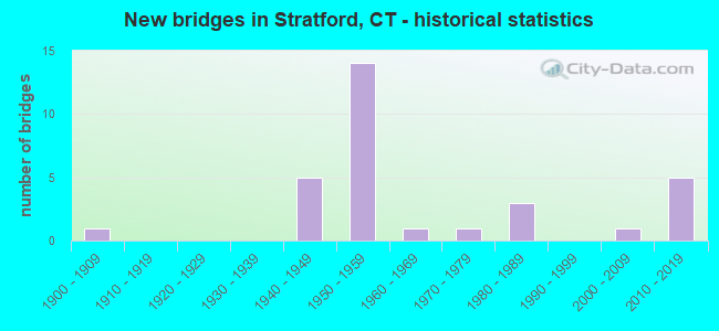
- New bridges - historical statistics
- 11900-1909
- 51940-1949
- 141950-1959
- 11960-1969
- 11970-1979
- 31980-1989
- 12000-2009
- 52010-2019
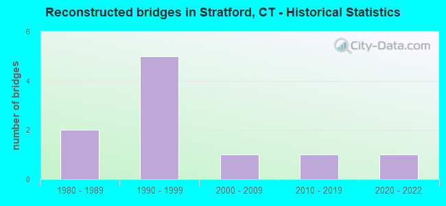
- Reconstructed bridges - Historical Statistics
- 21980-1989
- 51990-1999
- 12000-2009
- 12010-2019
- 12020-2022
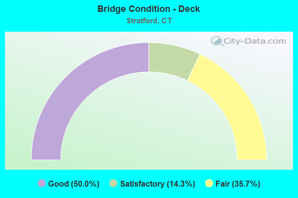
- Bridge Condition - Deck
- 50.0%Good
- 14.3%Satisfactory
- 35.7%Fair
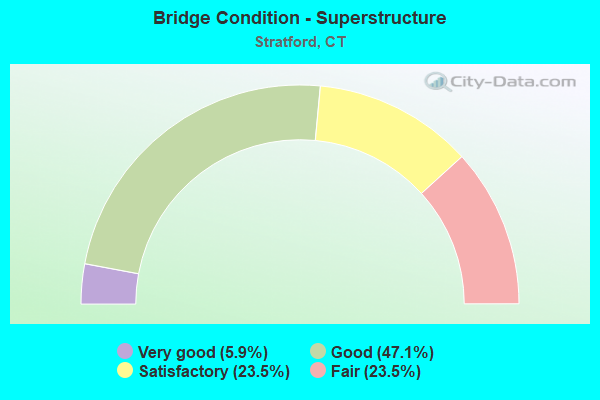
- Bridge Condition - Superstructure
- 5.9%Very good
- 47.1%Good
- 23.5%Satisfactory
- 23.5%Fair
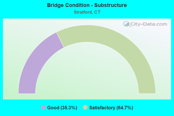
- Bridge Condition - Substructure
- 35.3%Good
- 64.7%Satisfactory
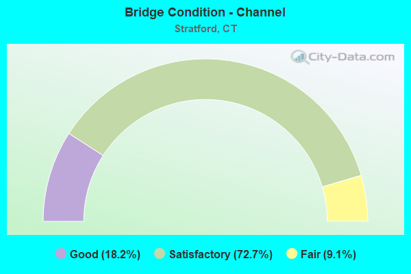
- Bridge Condition - Channel
- 18.2%Good
- 72.7%Satisfactory
- 9.1%Fair
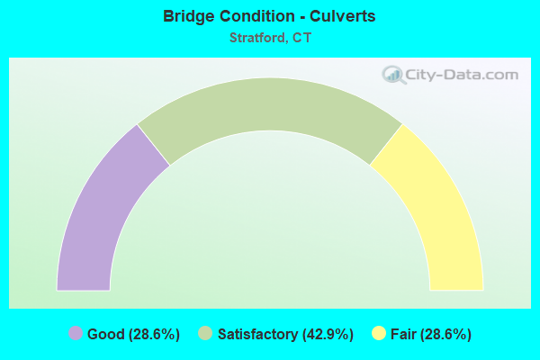
- Bridge Condition - Culverts
- 28.6%Good
- 42.9%Satisfactory
- 28.6%Fair
Find on map >> Show street view
Structure Number: 123, Location: 0.2 MI N OF ROUTE 113 (Lat: 41.174772, Lng: -73.154639), Route carried "on" structure: Interstate 95, Year Built: 1959, Year Reconstructed: 1995, Status: Open, Structure Length: 5.46m (17.91ft), Average Daily Traffic: 112,200 (year 2017), Truck Traffic: 9%, Average Future Daily Traffic: 166,718 (year 2037), Design Load: HS 20, Features Intersected: SURF AVENUE
Minimum Vertical Clearance: 30+ m (98+ ft), Kilometerpoint: 50.372, Lanes on structure: 6, Lanes under structure: 2, Base Highway Network: Yes, Owner: State Highway Agency, Approaching Roadway Width: 29.3m (96.1ft), Skew: 34 degrees, Material/Design: Steel continuous, Design/Construction: Stringer/Multi-beam, Number Of Spans In Main Unit: 3, Length of Maximum Span: 23.5m (77.1ft), Curb-To-Curb Width: 35.9m (117.8ft), Out-to-Out Width: 40.1m (131.6ft)
Condition: Deck: Good, Superstructure: Good, Substructure: Satisfactory, Operating Rating: 30.1 metric tons, Method Used To Determine Operating Rating: Load and Resistance Factor Rating (LRFR) rating reported by rating factor(RF) method using HL-93 loadings, Inventory Rating: 23.3 metric tons, Method Used To Determine Inventory Rating: Load and Resistance Factor Rating (LRFR) rating reported by rating factor(RF) method using HL-93 loadings, Structural Evaluation: Somewhat better than minimum adequacy, Deck Geometry: Superior to present desirable criteria, Underclear: Meets minimum limits, Approach Roadway Alignment: Equal to present desirable criteria, Designated Inspection Frequency: Every 24 months, Inspection Date: June 2020, Deck Structure Type: Concrete Cast-file-Place, Wearing Surface/Protective System: Wearing Surface: Bituminous, Membrane: Built-up, Deck Protection: Epoxy Coated Reinforcing
Find on map >> Show street view
Structure Number: 125, Location: 0.7 MI N OF ROUTE 113 (Lat: 41.178661, Lng: -73.147878), Route carried "on" structure: Interstate 95, Year Built: 1959, Year Reconstructed: 2000, Status: Open, Structure Length: 4.91m (16.11ft), Average Daily Traffic: 120,300 (year 2017), Truck Traffic: 10%, Average Future Daily Traffic: 178,754 (year 2037), Design Load: HS 20, Features Intersected: MOFFIT STREET
Minimum Vertical Clearance: 30+ m (98+ ft), Kilometerpoint: 51.097, Lanes on structure: 6, Lanes under structure: 2, Base Highway Network: Yes, Owner: State Highway Agency, Approaching Roadway Width: 29.3m (96.1ft), Skew: 32 degrees, Material/Design: Steel continuous, Design/Construction: Stringer/Multi-beam, Number Of Spans In Main Unit: 3, Length of Maximum Span: 20.7m (67.9ft), Curb-To-Curb Width: 35.9m (117.8ft), Out-to-Out Width: 38.8m (127.3ft)
Condition: Deck: Good, Superstructure: Good, Substructure: Satisfactory, Operating Rating: 34.0 metric tons, Method Used To Determine Operating Rating: Load and Resistance Factor Rating (LRFR) rating reported by rating factor(RF) method using HL-93 loadings, Inventory Rating: 24.9 metric tons, Method Used To Determine Inventory Rating: Load and Resistance Factor Rating (LRFR) rating reported by rating factor(RF) method using HL-93 loadings, Structural Evaluation: Equal to present minimum criteria, Deck Geometry: Superior to present desirable criteria, Underclear: Superior to present desirable criteria, Approach Roadway Alignment: Equal to present desirable criteria, Designated Inspection Frequency: Every 24 months, Inspection Date: May 2020, Deck Structure Type: Concrete Cast-file-Place, Wearing Surface/Protective System: Wearing Surface: Bituminous, Membrane: Built-up, Deck Protection: Epoxy Coated Reinforcing
Find on map >> Show street view
Structure Number: 126, Location: 0.5 MI SOUTH OF ROUTE 130 (Lat: 41.182281, Lng: -73.142936), Route carried "on" structure: Interstate 95, Year Built: 1959, Year Reconstructed: 1990, Status: Open, Structure Length: 5.00m (16.40ft), Average Daily Traffic: 92,800 (year 2020), Truck Traffic: 14%, Average Future Daily Traffic: 137,892 (year 2040), Design Load: HS 20, Features Intersected: HONEYSPOT ROAD
Minimum Vertical Clearance: 30+ m (98+ ft), Kilometerpoint: 51.676, Lanes on structure: 6, Lanes under structure: 2, Base Highway Network: Yes, Owner: State Highway Agency, Approaching Roadway Width: 36.0m (118.1ft), Skew: 33 degrees, Material/Design: Steel, Design/Construction: Stringer/Multi-beam, Number Of Spans In Main Unit: 3, Length of Maximum Span: 23.5m (77.1ft), Curb-To-Curb Width: 35.9m (117.8ft), Out-to-Out Width: 38.9m (127.6ft)
Condition: Deck: Fair, Superstructure: Fair, Substructure: Satisfactory, Operating Rating: 71.6 metric tons, Method Used To Determine Operating Rating: Load and Resistance Factor Rating (LRFR) rating reported by rating factor(RF) method using HL-93 loadings, Inventory Rating: 55.1 metric tons, Method Used To Determine Inventory Rating: Load and Resistance Factor Rating (LRFR) rating reported by rating factor(RF) method using HL-93 loadings, Structural Evaluation: Somewhat better than minimum adequacy, Deck Geometry: Superior to present desirable criteria, Underclear: Somewhat better than minimum adequacy, Approach Roadway Alignment: Equal to present desirable criteria, Designated Inspection Frequency: Every 24 months, Inspection Date: December 2021, Deck Structure Type: Concrete Cast-file-Place, Wearing Surface/Protective System: Wearing Surface: Bituminous, Membrane: Preformed Fabric, Deck Protection: Epoxy Coated Reinforcing
Find on map >> Show street view
Structure Number: 127, Location: 0.3 MI S OF ROUTE 130 (Lat: 41.183728, Lng: -73.140169), Route carried "on" structure: Interstate 95, Year Built: 1959, Year Reconstructed: 1989, Status: Open, Structure Length: 4.97m (16.31ft), Average Daily Traffic: 111,400 (year 2017), Truck Traffic: 9%, Average Future Daily Traffic: 165,529 (year 2037), Design Load: H 20, Features Intersected: SOUTH AVENUE NO. 1
Minimum Vertical Clearance: 30+ m (98+ ft), Kilometerpoint: 51.966, Lanes on structure: 6, Lanes under structure: 2, Base Highway Network: Yes, Owner: State Highway Agency, Approaching Roadway Width: 36.0m (118.1ft), Skew: 32 degrees, Material/Design: Steel, Design/Construction: Stringer/Multi-beam, Number Of Spans In Main Unit: 3, Length of Maximum Span: 24.4m (80.1ft), Curb-To-Curb Width: 35.9m (117.8ft), Out-to-Out Width: 38.9m (127.6ft)
Condition: Deck: Satisfactory, Superstructure: Fair, Substructure: Satisfactory, Operating Rating: 91.1 metric tons, Method Used To Determine Operating Rating: Load Factor (LF), Inventory Rating: 54.6 metric tons, Method Used To Determine Inventory Rating: Load Factor (LF), Structural Evaluation: Somewhat better than minimum adequacy, Deck Geometry: Superior to present desirable criteria, Underclear: Equal to present minimum criteria, Approach Roadway Alignment: Equal to present desirable criteria, Designated Inspection Frequency: Every 24 months, Inspection Date: May 2020, Deck Structure Type: Concrete Cast-file-Place, Wearing Surface/Protective System: Wearing Surface: Bituminous, Membrane: Preformed Fabric, Deck Protection: Epoxy Coated Reinforcing
Find on map >> Show street view
Structure Number: 129, Location: INTERSTATE-95 EXIT NO. 32 (Lat: 41.190433, Lng: -73.134172), Route carried "on" structure: Interstate 95, Year Built: 1958, Year Reconstructed: 2001, Status: Open, Structure Length: 3.32m (10.89ft), Average Daily Traffic: 107,800 (year 2017), Truck Traffic: 9%, Average Future Daily Traffic: 160,180 (year 2037), Design Load: HS 20, Features Intersected: WEST BROAD STREET
Minimum Vertical Clearance: 30+ m (98+ ft), Kilometerpoint: 52.883, Lanes on structure: 6, Lanes under structure: 4, Base Highway Network: Yes, Owner: State Highway Agency, Approaching Roadway Width: 36.0m (118.1ft), Skew: 30 degrees, Material/Design: Steel, Design/Construction: Stringer/Multi-beam, Number Of Spans In Main Unit: 2, Length of Maximum Span: 15.9m (52.2ft), Curb-To-Curb Width: 36.0m (118.1ft), Out-to-Out Width: 38.9m (127.6ft)
Condition: Deck: Fair, Superstructure: Fair, Substructure: Satisfactory, Operating Rating: 41.8 metric tons, Method Used To Determine Operating Rating: Load and Resistance Factor Rating (LRFR) rating reported by rating factor(RF) method using HL-93 loadings, Inventory Rating: 32.4 metric tons, Method Used To Determine Inventory Rating: Load and Resistance Factor Rating (LRFR) rating reported by rating factor(RF) method using HL-93 loadings, Structural Evaluation: Somewhat better than minimum adequacy, Deck Geometry: Superior to present desirable criteria, Underclear: Equal to present minimum criteria, Approach Roadway Alignment: Equal to present desirable criteria, Designated Inspection Frequency: Every 24 months, Inspection Date: August 2020, Deck Structure Type: Concrete Cast-file-Place, Wearing Surface/Protective System: Wearing Surface: Bituminous, Membrane: Built-up
Find on map >> Show street view
Structure Number: 13, Location: 0.5 MI N OF ROUTE 130 (Lat: 41.192728, Lng: -73.132414), Route carried "on" structure: Interstate 95, Year Built: 1958, Year Reconstructed: 2001, Status: Open, Structure Length: 2.12m (6.96ft), Average Daily Traffic: 113,500 (year 2017), Truck Traffic: 9%, Average Future Daily Traffic: 168,650 (year 2037), Design Load: H 20, Features Intersected: CHURCH STREET
Minimum Vertical Clearance: 30+ m (98+ ft), Kilometerpoint: 53.173, Lanes on structure: 7, Lanes under structure: 1, Base Highway Network: Yes, Owner: State Highway Agency, Approaching Roadway Width: 29.3m (96.1ft), Skew: 33 degrees, Material/Design: Steel, Design/Construction: Stringer/Multi-beam, Number Of Spans In Main Unit: 1, Length of Maximum Span: 19.6m (64.3ft), Curb-To-Curb Width: 39.7m (130.2ft), Out-to-Out Width: 41.7m (136.8ft)
Condition: Deck: Fair, Superstructure: Good, Substructure: Satisfactory, Operating Rating: 50.5 metric tons, Method Used To Determine Operating Rating: Load and Resistance Factor Rating (LRFR) rating reported by rating factor(RF) method using HL-93 loadings, Inventory Rating: 38.9 metric tons, Method Used To Determine Inventory Rating: Load and Resistance Factor Rating (LRFR) rating reported by rating factor(RF) method using HL-93 loadings, Structural Evaluation: Equal to present minimum criteria, Deck Geometry: Superior to present desirable criteria, Underclear: Equal to present minimum criteria, Approach Roadway Alignment: Equal to present desirable criteria, Designated Inspection Frequency: Every 24 months, Inspection Date: March 2020, Deck Structure Type: Concrete Cast-file-Place, Wearing Surface/Protective System: Wearing Surface: Bituminous, Membrane: Preformed Fabric
Find on map >> Show street view
Structure Number: 131, Location: 0.6 MI N OF ROUTE 130 (Lat: 41.193761, Lng: -73.131189), Route carried "on" structure: Interstate 95, Year Built: 1958, Status: Open, Structure Length: 2.62m (8.60ft), Average Daily Traffic: 120,000 (year 2017), Truck Traffic: 9%, Average Future Daily Traffic: 178,308 (year 2037), Design Load: HS 20, Features Intersected: ROUTE 113 (MAIN ST.)
Minimum Vertical Clearance: 30+ m (98+ ft), Kilometerpoint: 53.334, Lanes on structure: 6, Lanes under structure: 3, Base Highway Network: Yes, Owner: State Highway Agency, Approaching Roadway Width: 30.2m (99.1ft), Skew: 30 degrees, Material/Design: Steel, Design/Construction: Stringer/Multi-beam, Number Of Spans In Main Unit: 1, Length of Maximum Span: 25.0m (82.0ft), Curb-To-Curb Width: 30.2m (99.1ft), Out-to-Out Width: 32.2m (105.6ft)
Condition: Deck: Satisfactory, Superstructure: Satisfactory, Substructure: Satisfactory, Operating Rating: 60.2 metric tons, Method Used To Determine Operating Rating: Load Factor (LF), Inventory Rating: 36.1 metric tons, Method Used To Determine Inventory Rating: Load Factor (LF), Structural Evaluation: Equal to present minimum criteria, Deck Geometry: Superior to present desirable criteria, Underclear: Equal to present minimum criteria, Approach Roadway Alignment: Equal to present desirable criteria, Designated Inspection Frequency: Every 24 months, Inspection Date: June 2020, Deck Structure Type: Concrete Cast-file-Place, Wearing Surface/Protective System: Wearing Surface: Bituminous, Membrane: Built-up
Find on map >> Show street view
Structure Number: 132, Location: 0.6 MI N OF ROUTE 113 (Lat: 41.196917, Lng: -73.121158), Route carried "on" structure: Interstate 95, Year Built: 1958, Status: Open, Structure Length: 2.16m (7.09ft), Average Daily Traffic: 101,800 (year 2017), Truck Traffic: 9%, Average Future Daily Traffic: 151,265 (year 2037), Design Load: H 20, Features Intersected: ROUTE 130 WESTBOUND
Minimum Vertical Clearance: 30+ m (98+ ft), Kilometerpoint: 54.267, Lanes on structure: 7, Lanes under structure: 2, Base Highway Network: Yes, Owner: State Highway Agency, Approaching Roadway Width: 29.3m (96.1ft), Skew: 33 degrees, Material/Design: Steel, Design/Construction: Stringer/Multi-beam, Number Of Spans In Main Unit: 1, Length of Maximum Span: 20.1m (65.9ft), Curb-To-Curb Width: 35.4m (116.1ft), Out-to-Out Width: 37.2m (122.0ft)
Condition: Deck: Fair, Superstructure: Fair, Substructure: Good, Operating Rating: 61.2 metric tons, Method Used To Determine Operating Rating: Load Factor (LF), Inventory Rating: 36.7 metric tons, Method Used To Determine Inventory Rating: Load Factor (LF), Structural Evaluation: Somewhat better than minimum adequacy, Deck Geometry: Superior to present desirable criteria, Underclear: Equal to present minimum criteria, Approach Roadway Alignment: Equal to present desirable criteria, Designated Inspection Frequency: Every 24 months, Inspection Date: May 2021, Deck Structure Type: Concrete Cast-file-Place, Wearing Surface/Protective System: Wearing Surface: Bituminous, Membrane: Preformed Fabric
Find on map >> Show street view
Structure Number: 133, Location: 0.2 MI N OF ROUTE 130 (Lat: 41.198678, Lng: -73.118192), Route carried "on" structure: Interstate 95, Year Built: 2014, Status: Open, Structure Length: 2.77m (9.09ft), Average Daily Traffic: 105,900 (year 2017), Truck Traffic: 9%, Average Future Daily Traffic: 157,357 (year 2037), Design Load: HL 93, Features Intersected: US ROUTE 1 NORTH BOUND
Minimum Vertical Clearance: 30+ m (98+ ft), Kilometerpoint: 54.573, Lanes on structure: 6, Lanes under structure: 2, Base Highway Network: Yes, Owner: State Highway Agency, Approaching Roadway Width: 34.8m (114.2ft), Skew: 12 degrees, Material/Design: Steel, Design/Construction: Stringer/Multi-beam, Number Of Spans In Main Unit: 1, Length of Maximum Span: 25.6m (84.0ft), Curb-To-Curb Width: 34.8m (114.2ft), Out-to-Out Width: 37.0m (121.4ft)
Condition: Deck: Good, Superstructure: Very good, Substructure: Good, Operating Rating: 80.7 metric tons, Method Used To Determine Operating Rating: Load and Resistance Factor Rating (LRFR) rating reported by rating factor(RF) method using HL-93 loadings, Inventory Rating: 62.2 metric tons, Method Used To Determine Inventory Rating: Load and Resistance Factor Rating (LRFR) rating reported by rating factor(RF) method using HL-93 loadings, Structural Evaluation: Better than present minimum criteria, Deck Geometry: Superior to present desirable criteria, Underclear: Equal to present minimum criteria, Approach Roadway Alignment: Equal to present desirable criteria, Designated Inspection Frequency: Every 24 months, Inspection Date: May 2021, Deck Structure Type: Concrete Cast-file-Place, Wearing Surface/Protective System: Wearing Surface: Bituminous, Membrane: Preformed Fabric, Deck Protection: Epoxy Coated Reinforcing
Find on map >> Show street view
Structure Number: 757, Location: 1.5 MI S OF ROUTE 110 (Lat: 41.238128, Lng: -73.130464), Route carried "on" structure: State highway 15, Year Built: 1940, Status: Posted for load-capacity, Structure Length: 1.46m (4.79ft), Average Daily Traffic: 81,500 (year 2015), Truck Traffic: 1%, Average Future Daily Traffic: 121,101 (year 2035), Design Load: H 20, Features Intersected: CUTSPRING ROAD
Minimum Vertical Clearance: 30+ m (98+ ft), Kilometerpoint: 56.874, Lanes on structure: 4, Lanes under structure: 2, Base Highway Network: Yes, Owner: State Highway Agency, Approaching Roadway Width: 17.1m (56.1ft), Skew: 20 degrees, Material/Design: Concrete, Design/Construction: Frame, Number Of Spans In Main Unit: 1, Length of Maximum Span: 14.6m (47.9ft), Curb or Sidewalk Widths: Left: 1.2m (3.9ft), Right: 1.2m (3.9ft), Curb-To-Curb Width: 17.1m (56.1ft), Out-to-Out Width: 27.4m (89.9ft)
Condition: Superstructure: Satisfactory, Substructure: Satisfactory, Operating Rating: 52.6 metric tons, Method Used To Determine Operating Rating: No rating analysis performed, Inventory Rating: 30.8 metric tons, Method Used To Determine Inventory Rating: No rating analysis performed, Structural Evaluation: Equal to present minimum criteria, Deck Geometry: High priority of corrective action, Underclear: High priority of corrective action, Approach Roadway Alignment: Equal to present desirable criteria, Designated Inspection Frequency: Every 24 months, Inspection Date: January 2020
Find on map >> Show street view
Structure Number: 759, Location: 0.8 MI S OF ROUTE 110 (Lat: 41.240944, Lng: -73.117361), Route carried "on" structure: City street , Year Built: 1940, Status: Open, Structure Length: 2.68m (8.79ft), Average Daily Traffic: 2,759 (year 2020), Truck Traffic: 2%, Average Future Daily Traffic: 4,100 (year 2040), Design Load: H 20, Features Intersected: ROUTE 15, Facility Carried by Structure: JAMES FARM ROAD
Minimum Vertical Clearance: 30+ m (98+ ft), Kilometerpoint: 0.274, Lanes on structure: 2, Lanes under structure: 4, Owner: State Highway Agency, Approaching Roadway Width: 8.2m (26.9ft), Skew: 1 degrees, Material/Design: Concrete, Design/Construction: Arch - Deck, Number Of Spans In Main Unit: 2, Length of Maximum Span: 11.6m (38.1ft), Curb or Sidewalk Widths: Left: 1.2m (3.9ft), Right: 0.2m (0.7ft), Curb-To-Curb Width: 8.1m (26.6ft), Out-to-Out Width: 10.7m (35.1ft)
Condition: Superstructure: Satisfactory, Substructure: Satisfactory, Operating Rating: 52.6 metric tons, Method Used To Determine Operating Rating: No rating analysis performed, Inventory Rating: 30.8 metric tons, Method Used To Determine Inventory Rating: No rating analysis performed, Structural Evaluation: Equal to present minimum criteria, Deck Geometry: High priority of corrective action, Underclear: High priority of corrective action, Approach Roadway Alignment: Equal to present minimum criteria, Designated Inspection Frequency: Every 24 months, Inspection Date: Febuary 2020
Find on map >> Show street view
Structure Number: 76, Location: ROUTE 15 - EXIT NO. 53 (Lat: 41.245172, Lng: -73.102547), Route carried "on" structure: State highway 15, Year Built: 1940, Year Reconstructed: 1997, Status: Posted for load-capacity, Structure Length: 2.35m (7.71ft), Average Daily Traffic: 88,700 (year 2019), Truck Traffic: 1%, Average Future Daily Traffic: 131,799 (year 2039), Design Load: HS 20, Features Intersected: ROUTE 110
Minimum Vertical Clearance: 30+ m (98+ ft), Kilometerpoint: 59.337, Lanes on structure: 6, Lanes under structure: 4, Base Highway Network: Yes, Owner: State Highway Agency, Approaching Roadway Width: 29.0m (95.1ft), Skew: 33 degrees, Material/Design: Steel, Design/Construction: Frame, Number Of Spans In Main Unit: 1, Length of Maximum Span: 19.8m (65.0ft), Curb-To-Curb Width: 28.9m (94.8ft), Out-to-Out Width: 33.0m (108.3ft)
Condition: Deck: Good, Superstructure: Satisfactory, Substructure: Satisfactory, Operating Rating: 78.9 metric tons, Method Used To Determine Operating Rating: Load Factor (LF), Inventory Rating: 47.2 metric tons, Method Used To Determine Inventory Rating: Load Factor (LF), Structural Evaluation: Equal to present minimum criteria, Deck Geometry: Better than present minimum criteria, Underclear: High priority of corrective action, Approach Roadway Alignment: Equal to present desirable criteria, Designated Inspection Frequency: Every 24 months, Inspection Date: November 2021, Deck Structure Type: Concrete Cast-file-Place, Wearing Surface/Protective System: Wearing Surface: Bituminous, Membrane: Preformed Fabric, Deck Protection: Epoxy Coated Reinforcing
Find on map >> Show street view
Structure Number: 761, Location: RTE 15 BETWEEN EX 53 & 54 (Lat: 41.246339, Lng: -73.092111), Route carried "on" structure: State highway 15, Year Built: 2004, Status: Posted for load-capacity, Structure Length: 55.60m (182.41ft), Average Daily Traffic: 93,200 (year 2015), Truck Traffic: 1%, Average Future Daily Traffic: 138,486 (year 2035), Design Load: HS 20, Features Intersected: HOUSATONIC RIVER & MNRR
Minimum Vertical Clearance: 30+ m (98+ ft), Kilometerpoint: 59.980, Lanes on structure: 6, Base Highway Network: Yes, Owner: State Highway Agency, Approaching Roadway Width: 33.5m (109.9ft), Skew: 30 degrees, Navigation Control: Yes ( Vertical Clearance: 25.9m (85.0ft), Horizontal Clearance: 45.7m (149.9ft)), Material/Design: Steel continuous, Design/Construction: Stringer/Multi-beam, Number Of Spans In Main Unit: 5, Length of Maximum Span: 120.1m (394.0ft), Curb or Sidewalk Widths: Left: 3.0m (9.8ft), Right: 0.0m, Curb-To-Curb Width: 33.6m (110.2ft), Out-to-Out Width: 40.1m (131.6ft)
Condition: Deck: Good, Superstructure: Good, Substructure: Good, Channel: Satisfactory, Operating Rating: 58.8 metric tons, Method Used To Determine Operating Rating: Load Factor (LF), Inventory Rating: 33.7 metric tons, Method Used To Determine Inventory Rating: Load Factor (LF), Structural Evaluation: Better than present minimum criteria, Deck Geometry: Superior to present desirable criteria, Underclear: Equal to present minimum criteria, Waterway Adequacy: Equal to present desirable criteria, Approach Roadway Alignment: Equal to present desirable criteria, Designated Inspection Frequency: Every 24 months, Inspection Date: October 2020, Deck Structure Type: Concrete Cast-file-Place, Wearing Surface/Protective System: Wearing Surface: Bituminous, Membrane: Built-up, Deck Protection: Epoxy Coated Reinforcing
Find on map >> Show street view
Structure Number: 1313, Location: 1.0 MI N OF ROUTE 15 (Lat: 41.259069, Lng: -73.097753), Route carried "on" structure: State highway 110, Year Built: 1959, Status: Open, Structure Length: 1.86m (6.10ft), Average Daily Traffic: 17,500 (year 2016), Truck Traffic: 5%, Average Future Daily Traffic: 26,003 (year 2036), Design Load: HS 20, Features Intersected: FARMILL RIVER
Minimum Vertical Clearance: 30+ m (98+ ft), Kilometerpoint: 7.001, Lanes on structure: 2, Owner: State Highway Agency, Approaching Roadway Width: 12.2m (40.0ft), Skew: 1 degrees, Material/Design: Steel, Design/Construction: Stringer/Multi-beam, Number Of Spans In Main Unit: 1, Length of Maximum Span: 17.1m (56.1ft), Curb-To-Curb Width: 12.2m (40.0ft), Out-to-Out Width: 13.9m (45.6ft)
Condition: Deck: Fair, Superstructure: Good, Substructure: Good, Channel: Satisfactory, Operating Rating: 70.2 metric tons, Method Used To Determine Operating Rating: Load Factor (LF), Inventory Rating: 42.1 metric tons, Method Used To Determine Inventory Rating: Load Factor (LF), Structural Evaluation: Better than present minimum criteria, Deck Geometry: Somewhat better than minimum adequacy, Waterway Adequacy: Superior to present desirable criteria, Approach Roadway Alignment: Equal to present desirable criteria, Designated Inspection Frequency: Every 24 months, Inspection Date: May 2021, Deck Structure Type: Concrete Cast-file-Place, Wearing Surface/Protective System: Wearing Surface: Bituminous, Membrane: Preformed Fabric
Find on map >> Show street view
Structure Number: 2573, Location: 0.1 MI NORTH OF ROUTE 113 (Lat: 41.174725, Lng: -73.158094), Route carried "on" structure: Interstate 95, Year Built: 1959, Status: Open, Structure Length: 0.70m (2.30ft), Average Daily Traffic: 112,200 (year 2017), Truck Traffic: 9%, Average Future Daily Traffic: 166,718 (year 2037), Design Load: H 20, Features Intersected: JOHNSONS CREEK
Minimum Vertical Clearance: 30+ m (98+ ft), Kilometerpoint: 50.099, Lanes on structure: 6, Base Highway Network: Yes, Owner: State Highway Agency, Approaching Roadway Width: 36.0m (118.1ft), Skew: 33 degrees, Material/Design: Concrete continuous, Design/Construction: Culvert, Number Of Spans In Main Unit: 2, Length of Maximum Span: 3.4m (11.2ft)
Condition: Channel: Satisfactory, Culverts: Fair, Structural Evaluation: Somewhat better than minimum adequacy, Waterway Adequacy: Equal to present minimum criteria, Approach Roadway Alignment: Equal to present desirable criteria, Designated Inspection Frequency: Every 24 months, Inspection Date: May 2020
Find on map >> Show street view
Structure Number: 2622, Location: 0.4 MI S OF ROUTE 15 (Lat: 41.239642, Lng: -73.106086), Route carried "on" structure: State highway 110, Year Built: 2016, Status: Open, Structure Length: 1.14m (3.74ft), Average Daily Traffic: 10,700 (year 2016), Truck Traffic: 4%, Average Future Daily Traffic: 15,899 (year 2036), Design Load: HL 93, Features Intersected: FREEMAN BROOK
Minimum Vertical Clearance: 30+ m (98+ ft), Kilometerpoint: 4.699, Lanes on structure: 2, Base Highway Network: Yes, Owner: State Highway Agency, Approaching Roadway Width: 10.4m (34.1ft), Skew: 2 degrees, Material/Design: Concrete, Design/Construction: Frame, Number Of Spans In Main Unit: 1, Length of Maximum Span: 10.6m (34.8ft), Curb-To-Curb Width: 10.4m (34.1ft), Out-to-Out Width: 11.5m (37.7ft)
Condition: Deck: Good, Superstructure: Good, Substructure: Good, Channel: Satisfactory, Operating Rating: 47.0 metric tons, Method Used To Determine Operating Rating: Load and Resistance Factor Rating (LRFR) rating reported by rating factor(RF) method using HL-93 loadings, Inventory Rating: 36.3 metric tons, Method Used To Determine Inventory Rating: Load and Resistance Factor Rating (LRFR) rating reported by rating factor(RF) method using HL-93 loadings, Structural Evaluation: Better than present minimum criteria, Deck Geometry: Meets minimum limits, Waterway Adequacy: Equal to present desirable criteria, Approach Roadway Alignment: Better than present minimum criteria, Designated Inspection Frequency: Every 24 months, Inspection Date: June 2021, Wearing Surface/Protective System: Wearing Surface: Bituminous, Membrane: Epoxy, Deck Protection: Epoxy Coated Reinforcing
Find on map >> Show street view
Structure Number: 3751, Location: 300 FT N OF US ROUTE 1 (Lat: 41.199083, Lng: -73.124503), Route carried "on" structure: City street , Year Built: 1901, Year Reconstructed: 1994, Status: Open, Structure Length: 2.44m (8.01ft), Average Daily Traffic: 4,800 (year 2016), Truck Traffic: 2%, Average Future Daily Traffic: 7,132 (year 2036), Design Load: HS 20, Features Intersected: METRO NORTH RAILROAD, Facility Carried by Structure: LONGBROOK AVENUE
Minimum Vertical Clearance: 30+ m (98+ ft), Kilometerpoint: 0.853, Lanes on structure: 2, Maintenance Responsibility: State Highway Agency, Approaching Roadway Width: 7.3m (24.0ft), Skew: 2 degrees, Material/Design: Steel, Design/Construction: Stringer/Multi-beam, Number Of Spans In Main Unit: 1, Length of Maximum Span: 22.9m (75.1ft), Curb or Sidewalk Widths: Left: 0.0m, Right: 1.7m (5.6ft), Curb-To-Curb Width: 7.3m (24.0ft), Out-to-Out Width: 10.0m (32.8ft)
Condition: Deck: Good, Superstructure: Good, Substructure: Satisfactory, Operating Rating: 60.3 metric tons, Method Used To Determine Operating Rating: Load and Resistance Factor Rating (LRFR) rating reported by rating factor(RF) method using HL-93 loadings, Inventory Rating: 46.7 metric tons, Method Used To Determine Inventory Rating: Load and Resistance Factor Rating (LRFR) rating reported by rating factor(RF) method using HL-93 loadings, Structural Evaluation: Equal to present minimum criteria, Deck Geometry: High priority of replacement, Underclear: High priority of corrective action, Approach Roadway Alignment: Somewhat better than minimum adequacy, Designated Inspection Frequency: Every 24 months, Inspection Date: January 2021, Deck Structure Type: Concrete Precast Panels, Wearing Surface/Protective System: Wearing Surface: Bituminous, Membrane: Preformed Fabric, Deck Protection: Epoxy Coated Reinforcing
Find on map >> Show street view
Structure Number: 4944, Location: 0.8 M NORTH OF ROUTE 15 (Lat: 41.248650, Lng: -73.138583), Route carried "on" structure: City street , Year Built: 1965, Status: Open, Structure Length: 0.67m (2.20ft), Average Daily Traffic: 450 (year 2019), Truck Traffic: 2%, Average Future Daily Traffic: 669 (year 2039), Features Intersected: PUMPKIN GROUND BROOK, Facility Carried by Structure: BEAVER DAM ROAD
Minimum Vertical Clearance: 30+ m (98+ ft), Kilometerpoint: 0.724, Lanes on structure: 2, Owner: Town or Township Highway Agency, Approaching Roadway Width: 9.8m (32.2ft), Skew: 1 degrees, Material/Design: Concrete, Design/Construction: Culvert, Number Of Spans In Main Unit: 2, Length of Maximum Span: 3.0m (9.8ft), Curb or Sidewalk Widths: Left: 2.5m (8.2ft), Right: 2.4m (7.9ft), Curb-To-Curb Width: 9.7m (31.8ft), Out-to-Out Width: 15.2m (49.9ft)
Condition: Channel: Satisfactory, Culverts: Satisfactory, Operating Rating: 42.6 metric tons, Method Used To Determine Operating Rating: Field evaluation and documented engineering judgment, Inventory Rating: 32.7 metric tons, Method Used To Determine Inventory Rating: Field evaluation and documented engineering judgment, Structural Evaluation: Equal to present minimum criteria, Deck Geometry: Equal to present minimum criteria, Waterway Adequacy: Better than present minimum criteria, Approach Roadway Alignment: Equal to present desirable criteria, Designated Inspection Frequency: Every 24 months, Inspection Date: December 2020
Find on map >> Show street view
Structure Number: 4945, Location: 0.5 M N OF RT 110 & 113 (Lat: 41.225708, Lng: -73.123036), Route carried "on" structure: City street , Year Built: 2014, Status: Open, Structure Length: 0.85m (2.79ft), Average Daily Traffic: 870 (year 2019), Truck Traffic: 4%, Average Future Daily Traffic: 1,293 (year 2039), Design Load: HL 93, Features Intersected: PUMPKIN GROUND BROOK, Facility Carried by Structure: WHIPPOORWILL LA #1
Minimum Vertical Clearance: 30+ m (98+ ft), Kilometerpoint: 0.000, Lanes on structure: 2, Owner: Town or Township Highway Agency, Approaching Roadway Width: 6.7m (22.0ft), Material/Design: Concrete, Design/Construction: Arch - Deck, Number Of Spans In Main Unit: 1, Length of Maximum Span: 8.5m (27.9ft), Curb-To-Curb Width: 7.6m (24.9ft), Out-to-Out Width: 13.4m (44.0ft)
Condition: Superstructure: Good, Substructure: Good, Channel: Good, Operating Rating: 67.7 metric tons, Method Used To Determine Operating Rating: Load and Resistance Factor Rating (LRFR) rating reported by rating factor(RF) method using HL-93 loadings, Inventory Rating: 51.2 metric tons, Method Used To Determine Inventory Rating: Load and Resistance Factor Rating (LRFR) rating reported by rating factor(RF) method using HL-93 loadings, Structural Evaluation: Better than present minimum criteria, Deck Geometry: Meets minimum limits, Waterway Adequacy: Equal to present desirable criteria, Approach Roadway Alignment: Equal to present desirable criteria, Designated Inspection Frequency: Every 48 months, Inspection Date: January 2019
Find on map >> Show street view
Structure Number: 5945, Location: 0.2 MI N. OF ROUTE 15 (Lat: 41.240564, Lng: -73.132711), Route carried "on" structure: City street , Year Built: 1987, Status: Open, Structure Length: 0.73m (2.40ft), Average Daily Traffic: 1,800 (year 2016), Truck Traffic: 3%, Average Future Daily Traffic: 2,675 (year 2036), Features Intersected: PUMPKIN GROUND BROOK, Facility Carried by Structure: CUTSPRING ROAD
Minimum Vertical Clearance: 30+ m (98+ ft), Kilometerpoint: 2.655, Lanes on structure: 2, Owner: Town or Township Highway Agency, Approaching Roadway Width: 10.1m (33.1ft), Skew: 2 degrees, Material/Design: Concrete, Design/Construction: Culvert, Number Of Spans In Main Unit: 2, Length of Maximum Span: 3.4m (11.2ft), Curb-To-Curb Width: 10.1m (33.1ft), Out-to-Out Width: 17.4m (57.1ft)
Condition: Channel: Satisfactory, Culverts: Good, Operating Rating: 42.6 metric tons, Method Used To Determine Operating Rating: Field evaluation and documented engineering judgment, Inventory Rating: 32.7 metric tons, Method Used To Determine Inventory Rating: Field evaluation and documented engineering judgment, Structural Evaluation: Better than present minimum criteria, Deck Geometry: Somewhat better than minimum adequacy, Waterway Adequacy: Better than present minimum criteria, Approach Roadway Alignment: Better than present minimum criteria, Designated Inspection Frequency: Every 24 months, Inspection Date: December 2020
Find on map >> Show street view
Structure Number: 6096, Location: 0.7 MI N OF US ROUTE 1 (Lat: 41.204019, Lng: -73.148058), Route carried "on" structure: City street , Year Built: 1981, Year Reconstructed: 2016, Status: Open, Structure Length: 1.08m (3.54ft), Average Daily Traffic: 8,000 (year 2016), Truck Traffic: 3%, Average Future Daily Traffic: 11,887 (year 2036), Features Intersected: BRUCE BROOK, Facility Carried by Structure: BROADBRIDGE AVENUE
Minimum Vertical Clearance: 30+ m (98+ ft), Kilometerpoint: 0.000, Lanes on structure: 2, Owner: Town or Township Highway Agency, Approaching Roadway Width: 10.7m (35.1ft), Skew: 4 degrees, Material/Design: Concrete, Design/Construction: Culvert, Number Of Spans In Main Unit: 2, Length of Maximum Span: 4.7m (15.4ft), Curb or Sidewalk Widths: Left: 2.0m (6.6ft), Right: 1.4m (4.6ft), Curb-To-Curb Width: 11.0m (36.1ft), Out-to-Out Width: 15.3m (50.2ft)
Condition: Channel: Good, Culverts: Good, Operating Rating: 42.6 metric tons, Method Used To Determine Operating Rating: Field evaluation and documented engineering judgment, Inventory Rating: 32.7 metric tons, Method Used To Determine Inventory Rating: Field evaluation and documented engineering judgment, Structural Evaluation: Better than present minimum criteria, Deck Geometry: Meets minimum limits, Waterway Adequacy: Equal to present minimum criteria, Approach Roadway Alignment: Equal to present desirable criteria, Designated Inspection Frequency: Every 24 months, Inspection Date: December 2020
Find on map >> Show street view
Structure Number: 6132, Location: 330 FEET NORTH OF I-95 (Lat: 41.175767, Lng: -73.153675), Route carried "on" structure: City street , Year Built: 1955, Status: Open, Structure Length: 0.61m (2.00ft), Average Daily Traffic: 11,000 (year 2021), Truck Traffic: 5%, Average Future Daily Traffic: 16,345 (year 2041), Design Load: HS 20, Features Intersected: BROOK, Facility Carried by Structure: SURF AVENUE
Minimum Vertical Clearance: 30+ m (98+ ft), Kilometerpoint: 0.000, Lanes on structure: 2, Owner: Town or Township Highway Agency, Approaching Roadway Width: 11.0m (36.1ft), Skew: 3 degrees, Material/Design: Concrete continuous, Design/Construction: Culvert, Number Of Spans In Main Unit: 2, Length of Maximum Span: 2.7m (8.9ft), Curb or Sidewalk Widths: Left: 2.3m (7.5ft), Right: 2.1m (6.9ft), Curb-To-Curb Width: 10.9m (35.8ft), Out-to-Out Width: 17.2m (56.4ft)
Condition: Channel: Fair, Culverts: Fair, Operating Rating: 47.0 metric tons, Method Used To Determine Operating Rating: Load and Resistance Factor Rating (LRFR) rating reported by rating factor(RF) method using HL-93 loadings, Inventory Rating: 36.3 metric tons, Method Used To Determine Inventory Rating: Load and Resistance Factor Rating (LRFR) rating reported by rating factor(RF) method using HL-93 loadings, Structural Evaluation: Somewhat better than minimum adequacy, Deck Geometry: Meets minimum limits, Waterway Adequacy: Better than present minimum criteria, Approach Roadway Alignment: Equal to present desirable criteria, Designated Inspection Frequency: Every 24 months, Underwater Inspection Frequency: Every 24 months, Inspection Date: March 2021, Underwater Inspection Date: March 2021, Deck Structure Type: Other, Wearing Surface/Protective System: Wearing Surface: Bituminous
Find on map >> Show street view
Structure Number: 6133, Location: 200 FT EAST OF ROUTE 130 (Lat: 41.189864, Lng: -73.123664), Route carried "on" structure: City street , Year Built: 1981, Status: Open, Structure Length: 0.61m (2.00ft), Average Daily Traffic: 580 (year 2021), Truck Traffic: 2%, Average Future Daily Traffic: 862 (year 2041), Features Intersected: FERRY CREEK, Facility Carried by Structure: BROAD STREET
Minimum Vertical Clearance: 30+ m (98+ ft), Kilometerpoint: 0.000, Lanes on structure: 2, Owner: City or Municipal Highway Agency, Approaching Roadway Width: 8.5m (27.9ft), Skew: 3 degrees, Material/Design: Concrete, Design/Construction: Culvert, Number Of Spans In Main Unit: 2, Length of Maximum Span: 2.4m (7.9ft)
Condition: Channel: Satisfactory, Culverts: Satisfactory, Operating Rating: 42.6 metric tons, Method Used To Determine Operating Rating: Field evaluation and documented engineering judgment, Inventory Rating: 32.7 metric tons, Method Used To Determine Inventory Rating: Field evaluation and documented engineering judgment, Structural Evaluation: Equal to present minimum criteria, Waterway Adequacy: Equal to present desirable criteria, Approach Roadway Alignment: Equal to present desirable criteria, Designated Inspection Frequency: Every 24 months, Underwater Inspection Frequency: Every 24 months, Inspection Date: March 2021, Underwater Inspection Date: March 2021
Find on map >> Show street view
Structure Number: 7016, Location: 0.2 MI N OF CUTSPRING RD (Lat: 41.240944, Lng: -73.129306), Route carried "on" structure: City street , Year Built: 1976, Year Reconstructed: 2020, Status: Open, Structure Length: 0.64m (2.10ft), Average Daily Traffic: 100 (year 2020), Truck Traffic: 5%, Average Future Daily Traffic: 149 (year 2040), Features Intersected: PUMPKIN GROUND BROOK, Facility Carried by Structure: CIRCLE DRIVE
Minimum Vertical Clearance: 30+ m (98+ ft), Kilometerpoint: 0.338, Lanes on structure: 2, Owner: Town or Township Highway Agency, Approaching Roadway Width: 7.2m (23.6ft), Material/Design: Steel, Design/Construction: Culvert, Number Of Spans In Main Unit: 2, Length of Maximum Span: 3.0m (9.8ft), Curb or Sidewalk Widths: Left: 1.2m (3.9ft), Right: 0.2m (0.7ft), Curb-To-Curb Width: 7.2m (23.6ft), Out-to-Out Width: 9.2m (30.2ft)
Condition: Channel: Satisfactory, Culverts: Satisfactory, Operating Rating: 94.0 metric tons, Method Used To Determine Operating Rating: Load and Resistance Factor Rating (LRFR) rating reported by rating factor(RF) method using HL-93 loadings, Inventory Rating: 72.3 metric tons, Method Used To Determine Inventory Rating: Load and Resistance Factor Rating (LRFR) rating reported by rating factor(RF) method using HL-93 loadings, Structural Evaluation: Equal to present minimum criteria, Deck Geometry: Somewhat better than minimum adequacy, Waterway Adequacy: Better than present minimum criteria, Approach Roadway Alignment: Equal to present minimum criteria, Designated Inspection Frequency: Every 24 months, Inspection Date: December 2020
Find on map >> Show street view
Structure Number: 128, Location: 1.5 MI N OF ROUTE 113 (Lat: 41.186853, Lng: -73.136819), Route carried "under" structure: State highway 130, Year Built: 1958, Structure Length: 0. m, Average Daily Traffic: 6,700 (year 2016), Truck Traffic: 2%, Features Intersected: ROUTE 130(STRATFORD AVE), Facility Carried by Structure: INTERSTATE-95
Minimum Vertical Clearance: 4.55m (14.93ft), Kilometerpoint: 10.799, Lanes on structure: 6, Lanes under structure: 2, Material/Design: Steel, Design/Construction: Stringer/Multi-beam, Length of Maximum Span: 24.7m (81.0ft)
Find on map >> Show street view
Structure Number: 131, Location: 0.6 MI N OF ROUTE 130 (Lat: 41.193761, Lng: -73.131189), Route carried "under" structure: State highway 113, Year Built: 1958, Structure Length: 0. m, Average Daily Traffic: 14,200 (year 2016), Truck Traffic: 5%, Features Intersected: ROUTE 113 (MAIN ST.), Facility Carried by Structure: INTERSTATE-95
Minimum Vertical Clearance: 4.72m (15.49ft), Kilometerpoint: 9.833, Lanes on structure: 6, Lanes under structure: 3, Material/Design: Steel, Design/Construction: Stringer/Multi-beam, Length of Maximum Span: 25.0m (82.0ft)
Find on map >> Show street view
Structure Number: 132, Location: 0.6 MI N OF ROUTE 113 (Lat: 41.196917, Lng: -73.121158), Route carried "under" structure: State highway 130, Year Built: 1958, Structure Length: 0. m, Average Daily Traffic: 11,100 (year 2015), Truck Traffic: 5%, Features Intersected: ROUTE 130 WESTBOUND, Facility Carried by Structure: I-95 & I-95 RAMP 1
Minimum Vertical Clearance: 4.78m (15.68ft), Kilometerpoint: 12.859, Lanes on structure: 7, Lanes under structure: 2, Material/Design: Steel, Design/Construction: Stringer/Multi-beam, Length of Maximum Span: 20.1m (65.9ft)
Find on map >> Show street view
Structure Number: 133, Location: 0.2 MI N OF ROUTE 130 (Lat: 41.198678, Lng: -73.118192), Route carried "under" structure: US 1, Year Built: 2014, Structure Length: 0. m, Average Daily Traffic: 26,400 (year 2016), Truck Traffic: 6%, Features Intersected: US ROUTE 1 NORTH BOUND, Facility Carried by Structure: INTERSTATE-95
Minimum Vertical Clearance: 4.88m (16.01ft), Kilometerpoint: 56.182, Lanes on structure: 6, Lanes under structure: 2, Material/Design: Steel, Design/Construction: Stringer/Multi-beam, Length of Maximum Span: 25.6m (84.0ft)
Find on map >> Show street view
Structure Number: 134, Location: 0.4 MI N OF ROUTE 130 (Lat: 41.200675, Lng: -73.116000), Route carried "under" structure: US 1, Year Built: 2014, Structure Length: 0. m, Average Daily Traffic: 38,200 (year 2016), Truck Traffic: 6%, Features Intersected: US ROUTE 1 SOUTHBOUND, Facility Carried by Structure: INTERSTATE-95
Minimum Vertical Clearance: 5.74m (18.83ft), Kilometerpoint: 56.472, Lanes on structure: 6, Lanes under structure: 3, Material/Design: Steel, Design/Construction: Stringer/Multi-beam, Length of Maximum Span: 52.0m (170.6ft)
Find on map >> Show street view
Structure Number: 759, Location: 0.8 MI S OF ROUTE 110 (Lat: 41.240944, Lng: -73.117361), Route carried "under" structure: State highway 15, Year Built: 1940, Structure Length: 0. m, Average Daily Traffic: 81,500 (year 2015), Truck Traffic: 1%, Features Intersected: ROUTE 15, Facility Carried by Structure: JAMES FARM ROAD
Minimum Vertical Clearance: 4.78m (15.68ft), Kilometerpoint: 58.033, Lanes on structure: 2, Lanes under structure: 4, Material/Design: Concrete, Design/Construction: Arch - Deck, Length of Maximum Span: 11.6m (38.1ft)
Find on map >> Show street view
Structure Number: 76, Location: ROUTE 15 - EXIT NO. 53 (Lat: 41.245172, Lng: -73.102547), Route carried "under" structure: State highway 110, Year Built: 1940, Structure Length: 0. m, Average Daily Traffic: 25,800 (year 2016), Truck Traffic: 6%, Features Intersected: ROUTE 110, Facility Carried by Structure: ROUTE 15
Minimum Vertical Clearance: 5.08m (16.67ft), Kilometerpoint: 5.391, Lanes on structure: 6, Lanes under structure: 4, Material/Design: Steel, Design/Construction: Frame, Length of Maximum Span: 19.8m (65.0ft)