Bridge Statistics for Stuarts Draft, Virginia (VA)
Condition, Traffic, Stress, Structural Evaluation, Project Costs
- National Bridge Inventory (NBI) Statistics
- 12Number of bridges
- 85ft / 26.5mTotal length
- $496,000Total costs
- 74,546Total average daily traffic
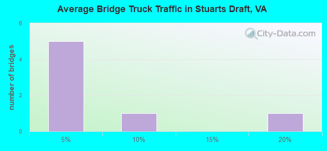
- 7,285Total average daily truck traffic
- National Bridge Inventory (NBI) Registered Bridges for Stuarts Draft
- No street view available for this location
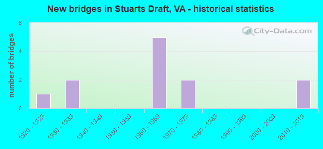
- New bridges - historical statistics
- 11920-1929
- 21930-1939
- 51960-1969
- 21970-1979
- 22010-2019

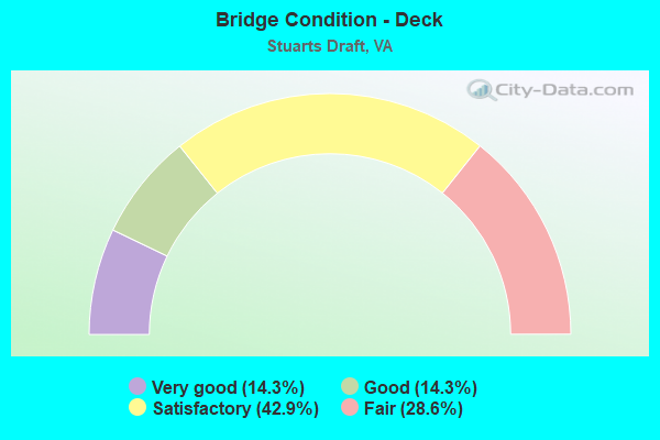
- Bridge Condition - Deck
- 14.3%Very good
- 14.3%Good
- 42.9%Satisfactory
- 28.6%Fair
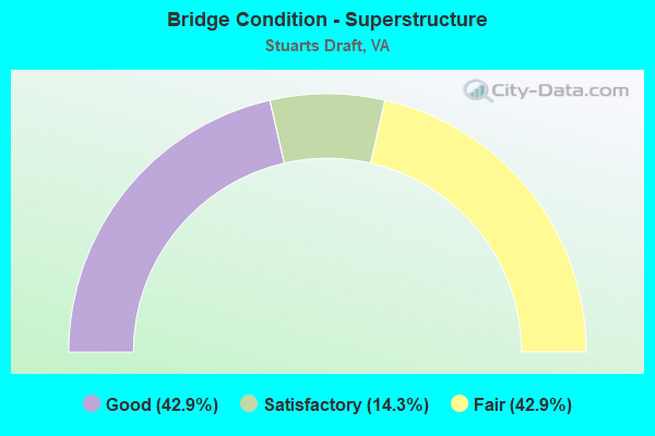
- Bridge Condition - Superstructure
- 42.9%Good
- 14.3%Satisfactory
- 42.9%Fair
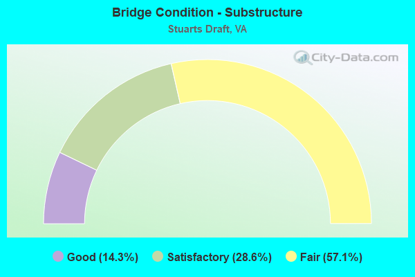
- Bridge Condition - Substructure
- 14.3%Good
- 28.6%Satisfactory
- 57.1%Fair
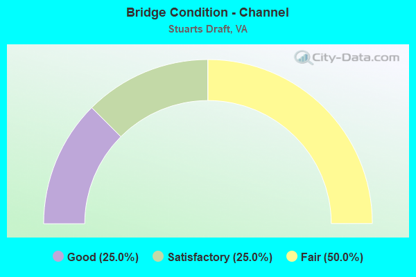
- Bridge Condition - Channel
- 25.0%Good
- 25.0%Satisfactory
- 50.0%Fair
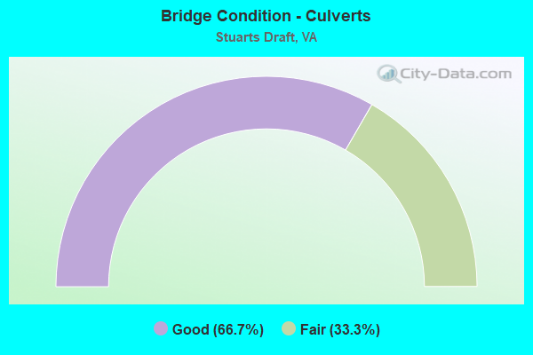
- Bridge Condition - Culverts
- 66.7%Good
- 33.3%Fair
Find on map >> Show street view
Structure Number: 1913, Location: 0.64 RT 655 - 0.12 RT 652 (Lat: 38.044036, Lng: -79.087669), Route carried "on" structure: US 340, Year Built: 1935, Year Reconstructed: 1960, Status: Open, Structure Length: 2.02m (6.63ft), Average Daily Traffic: 5,655 (year 2020), Truck Traffic: 5%, Average Future Daily Traffic: 6,220 (year 2040), Design Load: H 15, Features Intersected: CHRISTIANS CREEK, Facility Carried by Structure: STUARTS DRAFT HWY
Minimum Vertical Clearance: 30+ m (98+ ft), Kilometerpoint: 5.564, Lanes on structure: 2, Owner: State Highway Agency, Approaching Roadway Width: 6.6m (21.7ft), Skew: 4 degrees, Material/Design: Concrete, Design/Construction: Tee Beam, Number Of Spans In Main Unit: 2, Length of Maximum Span: 9.5m (31.2ft), Curb-To-Curb Width: 9.6m (31.5ft), Out-to-Out Width: 10.5m (34.4ft)
Condition: Deck: Satisfactory, Superstructure: Fair, Substructure: Fair, Channel: Fair, Operating Rating: 45.4 metric tons, Method Used To Determine Operating Rating: Load and Resistance Factor (LRFR), Inventory Rating: 34.5 metric tons, Method Used To Determine Inventory Rating: Load and Resistance Factor (LRFR), Structural Evaluation: Somewhat better than minimum adequacy, Deck Geometry: High priority of corrective action, Waterway Adequacy: Equal to present minimum criteria, Approach Roadway Alignment: Equal to present desirable criteria, Length Of Structure Improvement: 1.98m (6.50ft), Designated Inspection Frequency: Every 24 months, Inspection Date: Febuary 2022, Bridge Improvement Cost: $55,000, Roadway Improvement Cost: $6,000, Total Project Cost: $61,000, Deck Structure Type: Concrete Cast-file-Place, Wearing Surface/Protective System: Wearing Surface: Bituminous
Find on map >> Show street view
Structure Number: 2089, Location: 0.40 RT 657 - 1.35 RT 608 (Lat: 38.022567, Lng: -79.094025), Route carried "on" structure: County highway 652, Year Built: 1935, Status: Open, Structure Length: 1.13m (3.71ft), Average Daily Traffic: 60 (year 2013), Average Future Daily Traffic: 92 (year 2040), Design Load: HS 20, Features Intersected: SOUTH RIVER, Facility Carried by Structure: WILDA RD
Minimum Vertical Clearance: 30+ m (98+ ft), Kilometerpoint: 3.303, Lanes on structure: 1, Owner: State Highway Agency, Approaching Roadway Width: 3.7m (12.1ft), Material/Design: Concrete, Design/Construction: Tee Beam, Number Of Spans In Main Unit: 1, Length of Maximum Span: 10.7m (35.1ft), Curb or Sidewalk Widths: Left: 0.2m (0.7ft), Right: 0.2m (0.7ft), Curb-To-Curb Width: 4.6m (15.1ft), Out-to-Out Width: 5.3m (17.4ft)
Condition: Deck: Satisfactory, Superstructure: Good, Substructure: Satisfactory, Channel: Fair, Operating Rating: 44.5 metric tons, Method Used To Determine Operating Rating: Field evaluation and documented engineering judgment, Inventory Rating: 32.7 metric tons, Method Used To Determine Inventory Rating: Field evaluation and documented engineering judgment, Structural Evaluation: Equal to present minimum criteria, Deck Geometry: Better than present minimum criteria, Waterway Adequacy: Better than present minimum criteria, Approach Roadway Alignment: Equal to present minimum criteria, Length Of Structure Improvement: 1.13m (3.71ft), Designated Inspection Frequency: Every 24 months, Inspection Date: August 2021, Bridge Improvement Cost: $71,000, Roadway Improvement Cost: $9,000, Total Project Cost: $80,000, Deck Structure Type: Concrete Cast-file-Place
Find on map >> Show street view
Structure Number: 209, Location: 0.14 RT 652 - 0.22 RT 831 (Lat: 38.058678, Lng: -79.066781), Route carried "on" structure: State highway 654, Year Built: 1978, Status: Open, Structure Length: 4.33m (14.21ft), Average Daily Traffic: 6,008 (year 2020), Truck Traffic: 3%, Average Future Daily Traffic: 7,214 (year 2040), Design Load: HS 20+Mod, Features Intersected: CHRISTIANS CREEK, Facility Carried by Structure: WHITE HILL RD
Minimum Vertical Clearance: 30+ m (98+ ft), Kilometerpoint: 3.852, Lanes on structure: 2, Owner: State Highway Agency, Approaching Roadway Width: 7.0m (23.0ft), Skew: 1 degrees, Material/Design: Steel, Design/Construction: Stringer/Multi-beam, Number Of Spans In Main Unit: 2, Length of Maximum Span: 21.3m (69.9ft), Curb-To-Curb Width: 9.7m (31.8ft), Out-to-Out Width: 10.6m (34.8ft)
Condition: Deck: Very good, Superstructure: Satisfactory, Substructure: Fair, Channel: Good, Operating Rating: 75.3 metric tons, Method Used To Determine Operating Rating: Load and Resistance Factor (LRFR), Inventory Rating: 58.1 metric tons, Method Used To Determine Inventory Rating: Load and Resistance Factor (LRFR), Structural Evaluation: Somewhat better than minimum adequacy, Deck Geometry: High priority of corrective action, Waterway Adequacy: Equal to present desirable criteria, Approach Roadway Alignment: Equal to present desirable criteria, Designated Inspection Frequency: Every 24 months, Inspection Date: April 2021, Deck Structure Type: Concrete Cast-file-Place, Wearing Surface/Protective System: Wearing Surface: Epoxy Overlay
Find on map >> Show street view
Structure Number: 2096, Location: 1.40 RT 340 - 0.20 RT 11 (Lat: 38.059764, Lng: -79.111944), Route carried "on" structure: County highway 655, Year Built: 1968, Status: Open, Structure Length: 4.65m (15.26ft), Average Daily Traffic: 274 (year 2020), Truck Traffic: 3%, Average Future Daily Traffic: 298 (year 2040), Design Load: HS 20+Mod, Features Intersected: NBL RTE 81, Facility Carried by Structure: WALNUT HILLS RD.
Minimum Vertical Clearance: 30+ m (98+ ft), Kilometerpoint: 0.322, Lanes on structure: 2, Lanes under structure: 2, Owner: State Highway Agency, Approaching Roadway Width: 7.9m (25.9ft), Skew: 1 degrees, Material/Design: Steel, Design/Construction: Stringer/Multi-beam, Number Of Spans In Main Unit: 3, Length of Maximum Span: 18.7m (61.4ft), Curb or Sidewalk Widths: Left: 0.5m (1.6ft), Right: 0.5m (1.6ft), Curb-To-Curb Width: 7.3m (24.0ft), Out-to-Out Width: 8.8m (28.9ft)
Condition: Deck: Satisfactory, Superstructure: Good, Substructure: Good, Operating Rating: 59.9 metric tons, Method Used To Determine Operating Rating: Load and Resistance Factor (LRFR), Inventory Rating: 46.3 metric tons, Method Used To Determine Inventory Rating: Load and Resistance Factor (LRFR), Structural Evaluation: Better than present minimum criteria, Deck Geometry: Somewhat better than minimum adequacy, Underclear: Equal to present minimum criteria, Approach Roadway Alignment: Equal to present desirable criteria, Designated Inspection Frequency: Every 24 months, Inspection Date: January 2021, Deck Structure Type: Concrete Cast-file-Place, Wearing Surface/Protective System: Wearing Surface: Epoxy Overlay
Find on map >> Show street view
Structure Number: 2098, Location: 1.60 RT 340 - 0.10 RT 11 (Lat: 38.060800, Lng: -79.113197), Route carried "on" structure: County highway 655, Year Built: 1968, Status: Open, Structure Length: 5.01m (16.44ft), Average Daily Traffic: 274 (year 2020), Truck Traffic: 3%, Average Future Daily Traffic: 298 (year 2040), Design Load: HS 20+Mod, Features Intersected: SBL RTE 81, Facility Carried by Structure: Walnut Hills Road
Minimum Vertical Clearance: 30+ m (98+ ft), Kilometerpoint: 0.161, Lanes on structure: 2, Lanes under structure: 2, Owner: State Highway Agency, Approaching Roadway Width: 7.9m (25.9ft), Material/Design: Steel, Design/Construction: Stringer/Multi-beam, Number Of Spans In Main Unit: 3, Length of Maximum Span: 19.5m (64.0ft), Curb or Sidewalk Widths: Left: 0.5m (1.6ft), Right: 0.5m (1.6ft), Curb-To-Curb Width: 7.3m (24.0ft), Out-to-Out Width: 8.8m (28.9ft)
Condition: Deck: Good, Superstructure: Good, Substructure: Satisfactory, Operating Rating: 66.2 metric tons, Method Used To Determine Operating Rating: Load and Resistance Factor (LRFR), Inventory Rating: 50.8 metric tons, Method Used To Determine Inventory Rating: Load and Resistance Factor (LRFR), Structural Evaluation: Equal to present minimum criteria, Deck Geometry: Somewhat better than minimum adequacy, Underclear: Equal to present minimum criteria, Approach Roadway Alignment: Equal to present desirable criteria, Designated Inspection Frequency: Every 24 months, Inspection Date: January 2021, Deck Structure Type: Concrete Cast-file-Place, Wearing Surface/Protective System: Wearing Surface: Epoxy Overlay
Find on map >> Show street view
Structure Number: 21, Location: 0.02 TO 657 - 0.63 TO 899 (Lat: 38.025906, Lng: -79.065128), Route carried "on" structure: County highway 656, Year Built: 1966, Status: Open, Structure Length: 5.33m (17.49ft), Average Daily Traffic: 2,902 (year 2020), Truck Traffic: 2%, Average Future Daily Traffic: 4,063 (year 2040), Design Load: HS 20+Mod, Features Intersected: SOUTH RIVER, Facility Carried by Structure: Offliter Road
Minimum Vertical Clearance: 30+ m (98+ ft), Kilometerpoint: 1.046, Lanes on structure: 2, Owner: State Highway Agency, Approaching Roadway Width: 6.1m (20.0ft), Skew: 4 degrees, Material/Design: Steel, Design/Construction: Stringer/Multi-beam, Number Of Spans In Main Unit: 3, Length of Maximum Span: 17.4m (57.1ft), Curb or Sidewalk Widths: Left: 0.2m (0.7ft), Right: 0.2m (0.7ft), Curb-To-Curb Width: 8.1m (26.6ft), Out-to-Out Width: 9.1m (29.9ft)
Condition: Deck: Fair, Superstructure: Fair, Substructure: Fair, Channel: Good, Operating Rating: 67.1 metric tons, Method Used To Determine Operating Rating: Load and Resistance Factor (LRFR), Inventory Rating: 51.7 metric tons, Method Used To Determine Inventory Rating: Load and Resistance Factor (LRFR), Structural Evaluation: Somewhat better than minimum adequacy, Deck Geometry: High priority of corrective action, Waterway Adequacy: Equal to present minimum criteria, Approach Roadway Alignment: Equal to present minimum criteria, Length Of Structure Improvement: 5.33m (17.49ft), Designated Inspection Frequency: Every 24 months, Inspection Date: May 2020, Bridge Improvement Cost: $200,000, Roadway Improvement Cost: $50,000, Total Project Cost: $250,000, Deck Structure Type: Concrete Cast-file-Place, Wearing Surface/Protective System: Wearing Surface: Epoxy Overlay
Find on map >> Show street view
Structure Number: 2366, Location: 0.41 RT 654 - 0.18 RT 652 (Lat: 38.056136, Lng: -79.071200), Route carried "on" structure: County highway 831, Year Built: 1925, Status: Open, Structure Length: 1.38m (4.53ft), Average Daily Traffic: 444 (year 2016), Average Future Daily Traffic: 497 (year 2040), Features Intersected: CHRISTIANS CREEK, Facility Carried by Structure: OLD WHITE HILL RD.
Minimum Vertical Clearance: 30+ m (98+ ft), Kilometerpoint: 0.647, Lanes on structure: 1, Owner: State Highway Agency, Approaching Roadway Width: 6.1m (20.0ft), Material/Design: Concrete, Design/Construction: Slab, Number Of Spans In Main Unit: 2, Length of Maximum Span: 6.9m (22.6ft), Curb-To-Curb Width: 5.4m (17.7ft), Out-to-Out Width: 6.1m (20.0ft)
Condition: Deck: Fair, Superstructure: Fair, Substructure: Fair, Channel: Fair, Operating Rating: 32.7 metric tons, Method Used To Determine Operating Rating: Field evaluation and documented engineering judgment, Inventory Rating: 32.7 metric tons, Method Used To Determine Inventory Rating: Field evaluation and documented engineering judgment, Structural Evaluation: Somewhat better than minimum adequacy, Deck Geometry: High priority of replacement, Waterway Adequacy: Equal to present minimum criteria, Approach Roadway Alignment: Somewhat better than minimum adequacy, Length Of Structure Improvement: 1.37m (4.49ft), Designated Inspection Frequency: Every 24 months, Inspection Date: Febuary 2021, Bridge Improvement Cost: $50,000, Roadway Improvement Cost: $10,000, Total Project Cost: $60,000, Deck Structure Type: Concrete Cast-file-Place, Wearing Surface/Protective System: Wearing Surface: Bituminous
Find on map >> Show street view
Structure Number: 2306, Location: 0.82 TO 639 & 0.22 TO 633 (Lat: 38.013550, Lng: -78.989100), Route carried "on" structure: County highway 634, Year Built: 1979, Status: Open, Structure Length: 1.06m (3.48ft), Average Daily Traffic: 2,389 (year 2020), Truck Traffic: 1%, Average Future Daily Traffic: 3,345 (year 2040), Design Load: HS 20, Features Intersected: SOUTH RIVER, Facility Carried by Structure: Patton Farm Rd
Minimum Vertical Clearance: 30+ m (98+ ft), Kilometerpoint: 3.733, Lanes on structure: 2, Owner: State Highway Agency, Approaching Roadway Width: 7.0m (23.0ft), Material/Design: Steel, Design/Construction: Culvert, Number Of Spans In Main Unit: 8, Length of Maximum Span: 0.8m (2.6ft)
Condition: Channel: Fair, Culverts: Fair, Operating Rating: 20.9 metric tons, Method Used To Determine Operating Rating: Field evaluation and documented engineering judgment, Inventory Rating: 11.8 metric tons, Method Used To Determine Inventory Rating: Field evaluation and documented engineering judgment, Structural Evaluation: High priority of corrective action, Waterway Adequacy: High priority of corrective action, Approach Roadway Alignment: Somewhat better than minimum adequacy, Designated Inspection Frequency: Every 24 months, Inspection Date: March 2022, Deck Structure Type: Concrete Cast-file-Place, Wearing Surface/Protective System: Wearing Surface: Monolithic Concrete
Find on map >> Show street view
Structure Number: 29471, Location: 0.93 rt 686 - 0.04 RT 340 (Lat: 38.040411, Lng: -79.107961), Route carried "on" structure: County highway 694, Year Built: 2010, Status: Open, Structure Length: 0.76m (2.49ft), Average Daily Traffic: 362 (year 2013), Average Future Daily Traffic: 557 (year 2040), Design Load: HS 20+Mod, Features Intersected: Trib Christains Creek, Facility Carried by Structure: Swartzel Shop Road
Minimum Vertical Clearance: 30+ m (98+ ft), Kilometerpoint: 0.000, Lanes on structure: 2, Owner: State Highway Agency, Approaching Roadway Width: 5.6m (18.4ft), Material/Design: Concrete, Design/Construction: Culvert, Number Of Spans In Main Unit: 2, Length of Maximum Span: 3.7m (12.1ft)
Condition: Channel: Satisfactory, Culverts: Good, Operating Rating: 44.5 metric tons, Method Used To Determine Operating Rating: Field evaluation and documented engineering judgment, Inventory Rating: 32.7 metric tons, Method Used To Determine Inventory Rating: Field evaluation and documented engineering judgment, Structural Evaluation: Better than present minimum criteria, Waterway Adequacy: Equal to present desirable criteria, Approach Roadway Alignment: Equal to present desirable criteria, Designated Inspection Frequency: Every 24 months, Inspection Date: October 2020
Find on map >> Show street view
Structure Number: 29623, Location: 1.69 Rt 651 - 0.09 Rt 608 (Lat: 38.064167, Lng: -79.029722), Route carried "on" structure: County highway 652, Year Built: 2011, Status: Open, Structure Length: 0.79m (2.59ft), Average Daily Traffic: 126 (year 2013), Average Future Daily Traffic: 159 (year 2040), Design Load: HS 20, Features Intersected: BARTERBROOK BRANCH, Facility Carried by Structure: GUTHRIE RD
Minimum Vertical Clearance: 30.45m (99.90ft), Kilometerpoint: 12.933, Lanes on structure: 2, Owner: State Highway Agency, Approaching Roadway Width: 4.3m (14.1ft), Material/Design: Concrete, Design/Construction: Culvert, Number Of Spans In Main Unit: 2, Length of Maximum Span: 3.4m (11.2ft)
Condition: Channel: Satisfactory, Culverts: Good, Operating Rating: 44.5 metric tons, Method Used To Determine Operating Rating: Field evaluation and documented engineering judgment, Inventory Rating: 32.7 metric tons, Method Used To Determine Inventory Rating: Field evaluation and documented engineering judgment, Structural Evaluation: Better than present minimum criteria, Waterway Adequacy: Somewhat better than minimum adequacy, Approach Roadway Alignment: Equal to present desirable criteria, Length Of Structure Improvement: 0.73m (2.40ft), Designated Inspection Frequency: Every 24 months, Inspection Date: August 2021, Bridge Improvement Cost: $30,000, Roadway Improvement Cost: $10,000, Total Project Cost: $45,000
Find on map >> Show street view
Structure Number: 2096, Location: 1.40 RT 340 - 0.20 RT 11 (Lat: 38.059764, Lng: -79.111944), Route carried "under" structure: Interstate 81, Year Built: 1968, Structure Length: 0. m, Average Daily Traffic: 42,042 (year 2008), Truck Traffic: 16%, Features Intersected: NBL RTE 81, Facility Carried by Structure: WALNUT HILLS RD.
Minimum Vertical Clearance: 5.31m (17.42ft), Kilometerpoint: 348.574, Lanes on structure: 2, Lanes under structure: 2, Material/Design: Steel, Design/Construction: Stringer/Multi-beam, Length of Maximum Span: 18.7m (61.4ft)
Find on map >> Show street view
Structure Number: 2098, Location: 1.60 RT 340 - 0.10 RT 11 (Lat: 38.060800, Lng: -79.113197), Route carried "under" structure: Interstate 81, Year Built: 1968, Structure Length: 0. m, Average Daily Traffic: 14,010 (year 1994), Features Intersected: SBL RTE 81, Facility Carried by Structure: Walnut Hills Road
Minimum Vertical Clearance: 5.39m (17.68ft), Kilometerpoint: 17.055, Lanes on structure: 2, Lanes under structure: 2, Material/Design: Steel, Design/Construction: Stringer/Multi-beam, Length of Maximum Span: 19.5m (64.0ft)