Bridge Statistics for Superior, Colorado (CO)
Condition, Traffic, Stress, Structural Evaluation, Project Costs
- National Bridge Inventory (NBI) Statistics
- 16Number of bridges
- 131ft / 40.0mTotal length
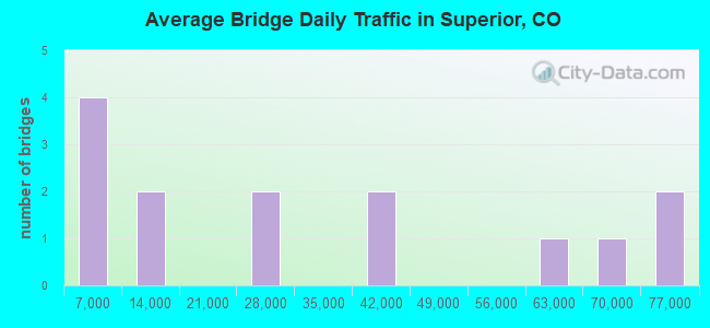
- 422,491Total average daily traffic
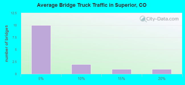
- 17,323Total average daily truck traffic
- National Bridge Inventory (NBI) Registered Bridges for Superior
- No street view available for this location
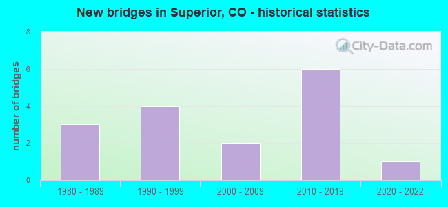
- New bridges - historical statistics
- 31980-1989
- 41990-1999
- 22000-2009
- 62010-2019
- 12020-2022
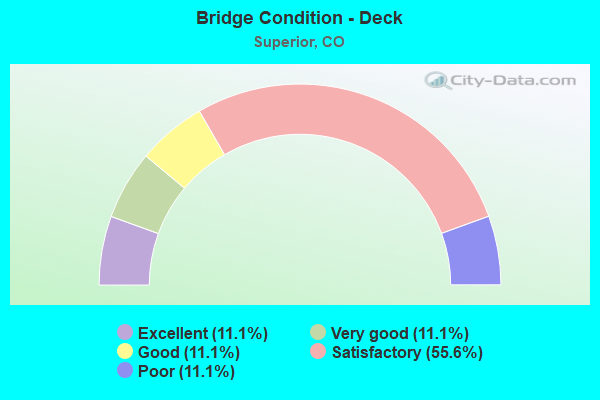
- Bridge Condition - Deck
- 11.1%Excellent
- 11.1%Very good
- 11.1%Good
- 55.6%Satisfactory
- 11.1%Poor
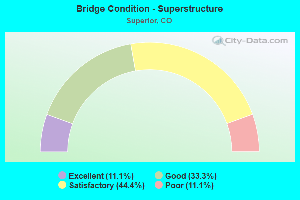
- Bridge Condition - Superstructure
- 11.1%Excellent
- 33.3%Good
- 44.4%Satisfactory
- 11.1%Poor
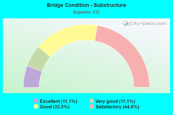
- Bridge Condition - Substructure
- 11.1%Excellent
- 11.1%Very good
- 33.3%Good
- 44.4%Satisfactory
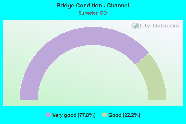
- Bridge Condition - Channel
- 77.8%Very good
- 22.2%Good
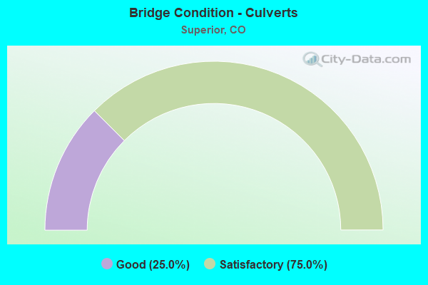
- Bridge Condition - Culverts
- 25.0%Good
- 75.0%Satisfactory
Find on map >> Show street view
Structure Number: E-16-KB, Location: IN WHEATRIDGE (Lat: 39.784253, Lng: -105.081011), Route carried "on" structure: Ramp Interstate 70A, Year Built: 1980, Status: Open, Structure Length: 5.41m (17.75ft), Average Daily Traffic: 59,000 (year 2020), Truck Traffic: 10%, Average Future Daily Traffic: 70,210 (year 2040), Design Load: HS 20+Mod, Features Intersected: CLEAR CREEK R, Facility Carried by Structure: NB RAMP TO I70/I76
Minimum Vertical Clearance: 30+ m (98+ ft), Kilometerpoint: 0.119, Lanes on structure: 1, Base Highway Network: Yes, Owner: State Highway Agency, Approaching Roadway Width: 11.0m (36.1ft), Skew: 9 degrees, Material/Design: Steel continuous, Design/Construction: Stringer/Multi-beam, Number Of Spans In Main Unit: 3, Length of Maximum Span: 21.1m (69.2ft), Curb-To-Curb Width: 11.0m (36.1ft), Out-to-Out Width: 12.0m (39.4ft)
Condition: Deck: Satisfactory, Superstructure: Good, Substructure: Satisfactory, Channel: Very good, Operating Rating: 41.1 metric tons, Method Used To Determine Operating Rating: Load Factor (LF), Inventory Rating: 24.6 metric tons, Method Used To Determine Inventory Rating: Load Factor (LF), Structural Evaluation: Equal to present minimum criteria, Deck Geometry: Superior to present desirable criteria, Waterway Adequacy: Superior to present desirable criteria, Approach Roadway Alignment: Equal to present desirable criteria, Designated Inspection Frequency: Every 24 months, Inspection Date: December 2021, Deck Structure Type: Concrete Cast-file-Place, Wearing Surface/Protective System: Wearing Surface: Bituminous, Membrane: Preformed Fabric
Find on map >> Show street view
Structure Number: E-16-KZ, Location: 3.9 MI E OF JCT SH 93 (Lat: 39.957517, Lng: -105.165553), Route carried "on" structure: State highway 170A, Year Built: 1983, Year Reconstructed: 2016, Status: Open, Structure Length: 5.87m (19.26ft), Average Daily Traffic: 24,000 (year 2020), Truck Traffic: 3%, Average Future Daily Traffic: 30,960 (year 2040), Design Load: HS 20+Mod, Features Intersected: US 36 ML, Facility Carried by Structure: SH170 ML(McCaslin)
Minimum Vertical Clearance: 30+ m (98+ ft), Kilometerpoint: 11.183, Lanes on structure: 6, Lanes under structure: 8, Owner: State Highway Agency, Approaching Roadway Width: 27.6m (90.6ft), Skew: 31 degrees, Material/Design: Prestressed concrete continuous, Design/Construction: Stringer/Multi-beam, Number Of Spans In Main Unit: 2, Length of Maximum Span: 29.0m (95.1ft), Curb-To-Curb Width: 27.6m (90.6ft), Out-to-Out Width: 33.2m (108.9ft)
Condition: Deck: Satisfactory, Superstructure: Satisfactory, Substructure: Good, Operating Rating: 22.7 metric tons, Method Used To Determine Operating Rating: Load and Resistance Factor Rating (LRFR) rating reported by rating factor(RF) method using HL-93 loadings, Inventory Rating: 17.5 metric tons, Method Used To Determine Inventory Rating: Load and Resistance Factor Rating (LRFR) rating reported by rating factor(RF) method using HL-93 loadings, Structural Evaluation: Meets minimum limits, Deck Geometry: Better than present minimum criteria, Underclear: Somewhat better than minimum adequacy, Approach Roadway Alignment: Equal to present desirable criteria, Designated Inspection Frequency: Every 24 months, Inspection Date: April 2021, Deck Structure Type: Concrete Cast-file-Place, Wearing Surface/Protective System: Wearing Surface: Bituminous, Membrane: Preformed Fabric, Deck Protection: Epoxy Coated Reinforcing
Find on map >> Show street view
Structure Number: E-16-ZA, Location: IN WESTMINSTER (Lat: 39.892275, Lng: -105.076072), Route carried "on" structure: US 36B, Year Built: 2017, Status: Open, Structure Length: 9.35m (30.68ft), Average Daily Traffic: 74,000 (year 2020), Truck Traffic: 3%, Average Future Daily Traffic: 86,580 (year 2040), Design Load: HL 93, Features Intersected: BNSF RR, Facility Carried by Structure: US 36 ML
Minimum Vertical Clearance: 30+ m (98+ ft), Kilometerpoint: 80.562, Lanes on structure: 6, Base Highway Network: Yes, Owner: State Highway Agency, Approaching Roadway Width: 46.9m (153.9ft), Skew: 4 degrees, Material/Design: Prestressed concrete continuous, Design/Construction: Box Beam or Girders - Multiple, Number Of Spans In Main Unit: 3, Length of Maximum Span: 37.5m (123.0ft), Curb or Sidewalk Widths: Left: 0.0m, Right: 3.7m (12.1ft), Curb-To-Curb Width: 46.9m (153.9ft), Out-to-Out Width: 52.4m (171.9ft)
Condition: Deck: Satisfactory, Superstructure: Satisfactory, Substructure: Satisfactory, Operating Rating: 50.2 metric tons, Method Used To Determine Operating Rating: Load and Resistance Factor Rating (LRFR) rating reported by rating factor(RF) method using HL-93 loadings, Inventory Rating: 38.9 metric tons, Method Used To Determine Inventory Rating: Load and Resistance Factor Rating (LRFR) rating reported by rating factor(RF) method using HL-93 loadings, Structural Evaluation: Equal to present minimum criteria, Deck Geometry: Superior to present desirable criteria, Underclear: Superior to present desirable criteria, Approach Roadway Alignment: Equal to present desirable criteria, Designated Inspection Frequency: Every 24 months, Inspection Date: August 2020, Deck Structure Type: Concrete Precast Panels, Wearing Surface/Protective System: Wearing Surface: Bituminous, Membrane: Preformed Fabric, Deck Protection: Epoxy Coated Reinforcing
Find on map >> Show street view
Structure Number: E-16-ZG, Location: JUST E of SUPERIOR INT. (Lat: 39.955156, Lng: -105.160694), Route carried "on" structure: US 36B, Year Built: 2015, Status: Open, Structure Length: 1.72m (5.64ft), Average Daily Traffic: 66,000 (year 2020), Truck Traffic: 2%, Average Future Daily Traffic: 75,240 (year 2040), Design Load: HS 20, Features Intersected: COAL CREEK, Facility Carried by Structure: US 36 ML
Minimum Vertical Clearance: 30.18m (99.02ft), Kilometerpoint: 70.285, Lanes on structure: 7, Base Highway Network: Yes, Owner: State Highway Agency, Approaching Roadway Width: 47.1m (154.5ft), Skew: 30 degrees, Material/Design: Concrete, Design/Construction: Culvert, Number Of Spans In Main Unit: 3, Length of Maximum Span: 6.1m (20.0ft), Out-to-Out Width: 64.8m (212.6ft)
Condition: Channel: Very good, Culverts: Good, Operating Rating: 59.1 metric tons, Method Used To Determine Operating Rating: Load Factor (LF), Inventory Rating: 45.5 metric tons, Method Used To Determine Inventory Rating: Load Factor (LF), Structural Evaluation: Better than present minimum criteria, Waterway Adequacy: Equal to present desirable criteria, Approach Roadway Alignment: Equal to present desirable criteria, Designated Inspection Frequency: Every 24 months, Inspection Date: July 2021
Find on map >> Show street view
Structure Number: E-16-ZI, Location: MCCASLIN and US 36 (Lat: 39.958525, Lng: -105.166483), Route carried "on" structure: Ramp US 36B, Year Built: 2016, Status: Open, Structure Length: 2.29m (7.51ft), Average Daily Traffic: 38,500 (year 2020), Truck Traffic: 2%, Average Future Daily Traffic: 44,660 (year 2040), Design Load: HL 93, Features Intersected: WB BUS RAMP/BIKE PATH, Facility Carried by Structure: WB US 36 ON RAMP
Minimum Vertical Clearance: 30+ m (98+ ft), Kilometerpoint: 0.080, Lanes on structure: 2, Lanes under structure: 1, Owner: State Highway Agency, Approaching Roadway Width: 11.0m (36.1ft), Skew: 4 degrees, Material/Design: Prestressed concrete, Design/Construction: Stringer/Multi-beam, Number Of Spans In Main Unit: 1, Length of Maximum Span: 21.6m (70.9ft), Curb-To-Curb Width: 11.0m (36.1ft), Out-to-Out Width: 11.9m (39.0ft)
Condition: Deck: Very good, Superstructure: Good, Substructure: Good, Operating Rating: 55.1 metric tons, Method Used To Determine Operating Rating: Load and Resistance Factor Rating (LRFR) rating reported by rating factor(RF) method using HL-93 loadings, Inventory Rating: 42.1 metric tons, Method Used To Determine Inventory Rating: Load and Resistance Factor Rating (LRFR) rating reported by rating factor(RF) method using HL-93 loadings, Structural Evaluation: Better than present minimum criteria, Deck Geometry: Better than present minimum criteria, Underclear: High priority of corrective action, Approach Roadway Alignment: Better than present minimum criteria, Designated Inspection Frequency: Every 24 months, Inspection Date: July 2021, Deck Structure Type: Concrete Precast Panels, Wearing Surface/Protective System: Wearing Surface: Bituminous, Membrane: Built-up, Deck Protection: Epoxy Coated Reinforcing
Find on map >> Show street view
Structure Number: E-16-ZJ, Location: McCASLIN and US 36 (Lat: 39.957558, Lng: -105.167078), Route carried "on" structure: Ramp US 36B, Year Built: 2016, Status: Open, Structure Length: 1.38m (4.53ft), Average Daily Traffic: 38,500 (year 2020), Truck Traffic: 2%, Average Future Daily Traffic: 44,660 (year 2040), Design Load: HL 93, Features Intersected: EB BUS RAMP, Facility Carried by Structure: EB US 36 OFF RAMP
Minimum Vertical Clearance: 30+ m (98+ ft), Kilometerpoint: 0.079, Lanes on structure: 2, Lanes under structure: 1, Owner: State Highway Agency, Approaching Roadway Width: 10.7m (35.1ft), Material/Design: Prestressed concrete, Design/Construction: Stringer/Multi-beam, Number Of Spans In Main Unit: 1, Length of Maximum Span: 11.9m (39.0ft), Curb-To-Curb Width: 12.2m (40.0ft), Out-to-Out Width: 13.1m (43.0ft)
Condition: Deck: Good, Superstructure: Good, Substructure: Very good, Operating Rating: 36.3 metric tons, Method Used To Determine Operating Rating: Field evaluation and documented engineering judgment, Inventory Rating: 32.7 metric tons, Method Used To Determine Inventory Rating: Field evaluation and documented engineering judgment, Structural Evaluation: Better than present minimum criteria, Deck Geometry: Superior to present desirable criteria, Underclear: High priority of corrective action, Approach Roadway Alignment: Better than present minimum criteria, Designated Inspection Frequency: Every 24 months, Inspection Date: July 2021, Deck Structure Type: Concrete Precast Panels, Wearing Surface/Protective System: Wearing Surface: Bituminous, Membrane: Built-up, Deck Protection: Epoxy Coated Reinforcing
Find on map >> Show street view
Structure Number: SUPER-2ND-AVE, Location: 0.2 Mi South of Williams (Lat: 39.952111, Lng: -105.168111), Route carried "on" structure: City street , Year Built: 1992, Status: Open, Structure Length: 2.02m (6.63ft), Average Daily Traffic: 562 (year 2020), Truck Traffic: 18%, Average Future Daily Traffic: 674 (year 2040), Design Load: HS 20, Features Intersected: Coal Creek, Facility Carried by Structure: 2nd Avenue
Minimum Vertical Clearance: 30+ m (98+ ft), Kilometerpoint: 0.282, Lanes on structure: 2, Owner: Town or Township Highway Agency, Approaching Roadway Width: 8.8m (28.9ft), Material/Design: Concrete, Design/Construction: Slab, Number Of Spans In Main Unit: 2, Length of Maximum Span: 9.1m (29.9ft), Curb-To-Curb Width: 6.7m (22.0ft), Out-to-Out Width: 7.6m (24.9ft)
Condition: Deck: Satisfactory, Superstructure: Satisfactory, Substructure: Good, Channel: Good, Operating Rating: 42.1 metric tons, Method Used To Determine Operating Rating: Load and Resistance Factor Rating (LRFR) rating reported by rating factor(RF) method using HL-93 loadings, Inventory Rating: 32.4 metric tons, Method Used To Determine Inventory Rating: Load and Resistance Factor Rating (LRFR) rating reported by rating factor(RF) method using HL-93 loadings, Structural Evaluation: Equal to present minimum criteria, Deck Geometry: Meets minimum limits, Waterway Adequacy: Equal to present desirable criteria, Approach Roadway Alignment: Equal to present desirable criteria, Designated Inspection Frequency: Every 24 months, Inspection Date: Febuary 2021, Deck Structure Type: Concrete Cast-file-Place, Wearing Surface/Protective System: Wearing Surface: Bituminous, Deck Protection: Epoxy Coated Reinforcing
Find on map >> Show street view
Structure Number: SUPER-COALTON, Location: 0.15 Mi East of McCaslin (Lat: 39.928972, Lng: -105.163333), Route carried "on" structure: City street , Year Built: 2000, Status: Open, Structure Length: 1.53m (5.02ft), Average Daily Traffic: 5,853 (year 2021), Truck Traffic: 3%, Average Future Daily Traffic: 7,024 (year 2041), Features Intersected: Rock Creek, Facility Carried by Structure: Coalton Drive
Minimum Vertical Clearance: 30+ m (98+ ft), Kilometerpoint: 0.220, Lanes on structure: 4, Owner: Town or Township Highway Agency, Approaching Roadway Width: 22.3m (73.2ft), Skew: 32 degrees, Material/Design: Concrete, Design/Construction: Culvert, Number Of Spans In Main Unit: 3, Length of Maximum Span: 4.9m (16.1ft), Curb or Sidewalk Widths: Left: 1.5m (4.9ft), Right: 1.5m (4.9ft), Out-to-Out Width: 47.9m (157.2ft)
Condition: Channel: Very good, Culverts: Satisfactory, Structural Evaluation: Equal to present minimum criteria, Waterway Adequacy: Equal to present desirable criteria, Approach Roadway Alignment: Equal to present desirable criteria, Designated Inspection Frequency: Every 24 months, Inspection Date: Febuary 2021
Find on map >> Show street view
Structure Number: SUPER-INDIANA, Location: 150 Ft N of Coalton D (Lat: 39.929778, Lng: -105.160000), Route carried "on" structure: City street , Year Built: 1999, Status: Open, Structure Length: 0.87m (2.85ft), Average Daily Traffic: 2,225 (year 2021), Truck Traffic: 2%, Average Future Daily Traffic: 2,670 (year 2041), Design Load: HS 20, Features Intersected: Rock Creek, Facility Carried by Structure: Indiana Avenue
Minimum Vertical Clearance: 30+ m (98+ ft), Kilometerpoint: 1.679, Lanes on structure: 3, Owner: Town or Township Highway Agency, Approaching Roadway Width: 19.5m (64.0ft), Material/Design: Concrete, Design/Construction: Culvert, Number Of Spans In Main Unit: 2, Length of Maximum Span: 4.3m (14.1ft), Curb or Sidewalk Widths: Left: 1.7m (5.6ft), Right: 1.7m (5.6ft), Out-to-Out Width: 47.0m (154.2ft)
Condition: Channel: Very good, Culverts: Satisfactory, Structural Evaluation: Equal to present minimum criteria, Waterway Adequacy: Equal to present desirable criteria, Approach Roadway Alignment: Equal to present desirable criteria, Designated Inspection Frequency: Every 24 months, Inspection Date: Febuary 2021
Find on map >> Show street view
Structure Number: SUPER-MARSHALL, Location: 0.07 Mi N of Creek View (Lat: 39.954189, Lng: -105.163058), Route carried "on" structure: City street , Year Built: 2022, Status: Open, Structure Length: 2.93m (9.61ft), Average Daily Traffic: 500 (year 2022), Truck Traffic: 1%, Average Future Daily Traffic: 1,000 (year 2032), Design Load: HL 93, Features Intersected: Coal Creek, Facility Carried by Structure: Marshall Road
Minimum Vertical Clearance: 30+ m (98+ ft), Kilometerpoint: 0.000, Lanes on structure: 2, Owner: Town or Township Highway Agency, Approaching Roadway Width: 10.1m (33.1ft), Material/Design: Prestressed concrete, Design/Construction: Box Beam or Girders - Multiple, Number Of Spans In Main Unit: 1, Length of Maximum Span: 27.4m (89.9ft), Curb or Sidewalk Widths: Left: 2.3m (7.5ft), Right: 2.3m (7.5ft), Curb-To-Curb Width: 9.8m (32.2ft), Out-to-Out Width: 15.2m (49.9ft)
Condition: Deck: Excellent, Superstructure: Excellent, Substructure: Excellent, Channel: Very good, Operating Rating: 74.2 metric tons, Method Used To Determine Operating Rating: Load and Resistance Factor Rating (LRFR) rating reported by rating factor(RF) method using HL-93 loadings, Inventory Rating: 34.3 metric tons, Method Used To Determine Inventory Rating: Load and Resistance Factor Rating (LRFR) rating reported by rating factor(RF) method using HL-93 loadings, Structural Evaluation: Superior to present desirable criteria, Deck Geometry: Equal to present minimum criteria, Waterway Adequacy: Equal to present desirable criteria, Approach Roadway Alignment: Equal to present desirable criteria, Designated Inspection Frequency: Every 24 months, Inspection Date: Febuary 2022, Deck Structure Type: Concrete Cast-file-Place, Wearing Surface/Protective System: Wearing Surface: Bituminous
Find on map >> Show street view
Structure Number: SUPER-MCCASLINA, Location: 0.3 Mi S of US Hwy 36 (Lat: 39.952889, Lng: -105.165528), Route carried "on" structure: City street , Year Built: 1995, Status: Open, Structure Length: 2.44m (8.01ft), Average Daily Traffic: 21,728 (year 2020), Truck Traffic: 7%, Average Future Daily Traffic: 26,074 (year 2040), Design Load: HS 20, Features Intersected: Coal Creek, Facility Carried by Structure: McCaslin Blvd
Minimum Vertical Clearance: 30+ m (98+ ft), Kilometerpoint: 5.016, Lanes on structure: 6, Owner: Town or Township Highway Agency, Approaching Roadway Width: 28.8m (94.5ft), Skew: 21 degrees, Material/Design: Prestressed concrete, Design/Construction: Box Beam or Girders - Single/Spread, Number Of Spans In Main Unit: 1, Length of Maximum Span: 23.3m (76.4ft), Curb or Sidewalk Widths: Left: 1.4m (4.6ft), Right: 1.4m (4.6ft), Curb-To-Curb Width: 28.8m (94.5ft), Out-to-Out Width: 35.5m (116.5ft)
Condition: Deck: Satisfactory, Superstructure: Satisfactory, Substructure: Satisfactory, Channel: Very good, Operating Rating: 61.2 metric tons, Method Used To Determine Operating Rating: Load Factor (LF), Inventory Rating: 36.5 metric tons, Method Used To Determine Inventory Rating: Load Factor (LF), Structural Evaluation: Equal to present minimum criteria, Deck Geometry: Superior to present desirable criteria, Waterway Adequacy: Equal to present desirable criteria, Approach Roadway Alignment: Equal to present desirable criteria, Designated Inspection Frequency: Every 24 months, Inspection Date: Febuary 2021, Deck Structure Type: Concrete Cast-file-Place, Wearing Surface/Protective System: Wearing Surface: Bituminous, Membrane: Built-up, Deck Protection: Epoxy Coated Reinforcing
Find on map >> Show street view
Structure Number: SUPER-ROCKCKBL, Location: 0.3 Mi N of Coalton D (Lat: 39.933222, Lng: -105.145778), Route carried "on" structure: City street , Year Built: 1999, Status: Open, Structure Length: 3.10m (10.17ft), Average Daily Traffic: 11,391 (year 2020), Truck Traffic: 5%, Average Future Daily Traffic: 13,669 (year 2040), Design Load: HS 20, Features Intersected: Rock Creek, Facility Carried by Structure: Rock Creek Pkwy.
Minimum Vertical Clearance: 30+ m (98+ ft), Kilometerpoint: 2.232, Lanes on structure: 4, Owner: Town or Township Highway Agency, Approaching Roadway Width: 20.3m (66.6ft), Skew: 34 degrees, Material/Design: Concrete, Design/Construction: Culvert, Number Of Spans In Main Unit: 4, Length of Maximum Span: 7.2m (23.6ft), Curb or Sidewalk Widths: Left: 1.5m (4.9ft), Right: 1.5m (4.9ft), Curb-To-Curb Width: 20.3m (66.6ft), Out-to-Out Width: 30.0m (98.4ft)
Condition: Channel: Good, Culverts: Satisfactory, Operating Rating: 41.0 metric tons, Method Used To Determine Operating Rating: Load Factor (LF), Inventory Rating: 24.5 metric tons, Method Used To Determine Inventory Rating: Load Factor (LF), Structural Evaluation: Equal to present minimum criteria, Deck Geometry: Equal to present desirable criteria, Waterway Adequacy: Equal to present desirable criteria, Approach Roadway Alignment: Equal to present desirable criteria, Designated Inspection Frequency: Every 24 months, Inspection Date: Febuary 2021
Find on map >> Show street view
Structure Number: SUPER-ROKCKBL-B, Location: 300 Ft East of McCaslin (Lat: 39.945389, Lng: -105.162500), Route carried "on" structure: City street , Year Built: 2000, Status: Open, Structure Length: 1.07m (3.51ft), Average Daily Traffic: 8,232 (year 2020), Truck Traffic: 4%, Average Future Daily Traffic: 9,878 (year 2040), Design Load: HS 20, Features Intersected: Community Ditch, Facility Carried by Structure: Rock Creek Pkwy
Minimum Vertical Clearance: 30+ m (98+ ft), Kilometerpoint: 0.105, Lanes on structure: 6, Owner: Town or Township Highway Agency, Approaching Roadway Width: 22.6m (74.1ft), Skew: 32 degrees, Material/Design: Concrete, Design/Construction: Frame, Number Of Spans In Main Unit: 1, Length of Maximum Span: 9.8m (32.2ft), Curb or Sidewalk Widths: Left: 2.7m (8.9ft), Right: 2.7m (8.9ft), Curb-To-Curb Width: 24.4m (80.1ft), Out-to-Out Width: 39.9m (130.9ft)
Condition: Deck: Poor, Superstructure: Poor, Substructure: Satisfactory, Channel: Very good, Operating Rating: 36.3 metric tons, Method Used To Determine Operating Rating: Field evaluation and documented engineering judgment, Inventory Rating: 32.7 metric tons, Method Used To Determine Inventory Rating: Field evaluation and documented engineering judgment, Structural Evaluation: Meets minimum limits, Deck Geometry: Somewhat better than minimum adequacy, Waterway Adequacy: Equal to present desirable criteria, Approach Roadway Alignment: Equal to present desirable criteria, Designated Inspection Frequency: Every 24 months, Inspection Date: Febuary 2021, Deck Structure Type: Concrete Cast-file-Place, Wearing Surface/Protective System: Wearing Surface: Bituminous
Find on map >> Show street view
Structure Number: E-16-KZ, Location: 3.9 MI E OF JCT SH 93 (Lat: 39.957517, Lng: -105.165553), Route carried "under" structure: US 36B, Year Built: 1983, Structure Length: 0. m, Average Daily Traffic: 72,000 (year 2011), Truck Traffic: 4%, Features Intersected: US 36 ML, Facility Carried by Structure: SH170 ML(McCaslin)
Minimum Vertical Clearance: 5.11m (16.77ft), Kilometerpoint: 69.506, Lanes on structure: 6, Lanes under structure: 5, Material/Design: Prestressed concrete continuous, Design/Construction: Stringer/Multi-beam, Length of Maximum Span: 29.0m (95.1ft)
Find on map >> Show street view
Structure Number: E-16-ZI, Location: MCCASLIN and US 36 (Lat: 39.958525, Lng: -105.166483), Route carried "under" structure: ServiceOther road , Year Built: 2016, Structure Length: 0. m, Features Intersected: WB BUS RAMP/BIKE PATH, Facility Carried by Structure: WB US 36 ON RAMP
Minimum Vertical Clearance: 4.88m (16.01ft), Kilometerpoint: 0.000, Lanes on structure: 2, Lanes under structure: 1, Material/Design: Prestressed concrete, Design/Construction: Stringer/Multi-beam, Length of Maximum Span: 21.6m (70.9ft)
Find on map >> Show street view
Structure Number: E-16-ZJ, Location: McCASLIN and US 36 (Lat: 39.957558, Lng: -105.167078), Route carried "under" structure: ServiceOther road , Year Built: 2016, Structure Length: 0. m, Features Intersected: EB BUS RAMP, Facility Carried by Structure: EB US 36 OFF RAMP
Minimum Vertical Clearance: 16.93m (55.54ft), Kilometerpoint: 0.000, Lanes on structure: 2, Lanes under structure: 1, Material/Design: Prestressed concrete, Design/Construction: Stringer/Multi-beam, Length of Maximum Span: 11.9m (39.0ft)