Bridge Statistics for Sutton, West Virginia (WV)
Condition, Traffic, Stress, Structural Evaluation, Project Costs
- National Bridge Inventory (NBI) Statistics
- 24Number of bridges
- 407ft / 124mTotal length
- $16,859,000Total costs
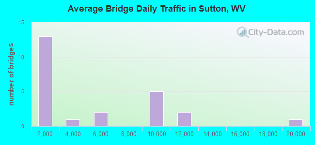
- 104,676Total average daily traffic
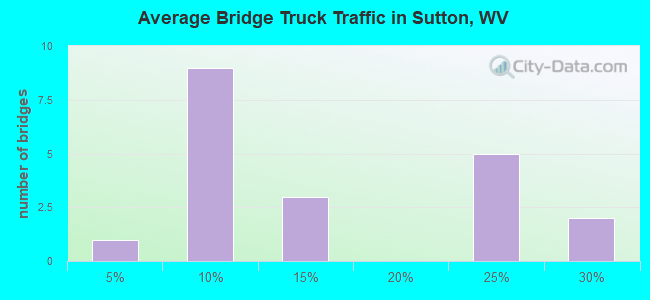
- 20,872Total average daily truck traffic
- National Bridge Inventory (NBI) Registered Bridges for Sutton
- No street view available for this location
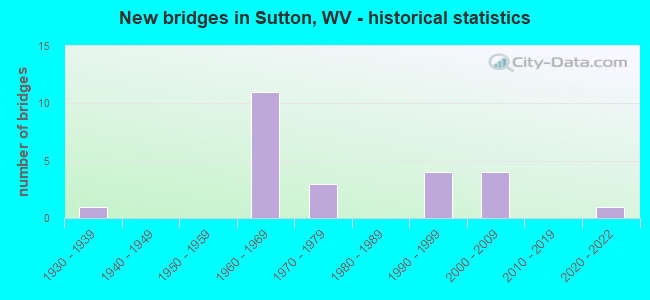
- New bridges - historical statistics
- 11930-1939
- 111960-1969
- 31970-1979
- 41990-1999
- 42000-2009
- 12020-2022
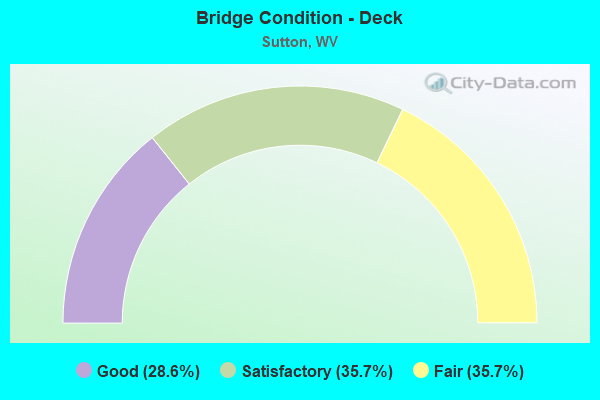
- Bridge Condition - Deck
- 28.6%Good
- 35.7%Satisfactory
- 35.7%Fair
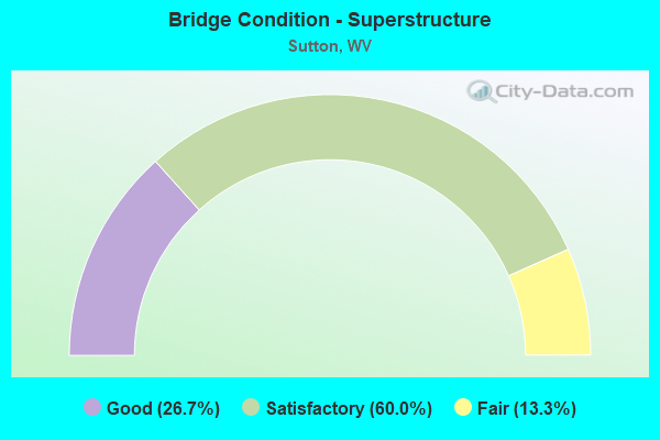
- Bridge Condition - Superstructure
- 26.7%Good
- 60.0%Satisfactory
- 13.3%Fair
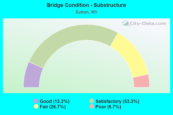
- Bridge Condition - Substructure
- 13.3%Good
- 53.3%Satisfactory
- 26.7%Fair
- 6.7%Poor
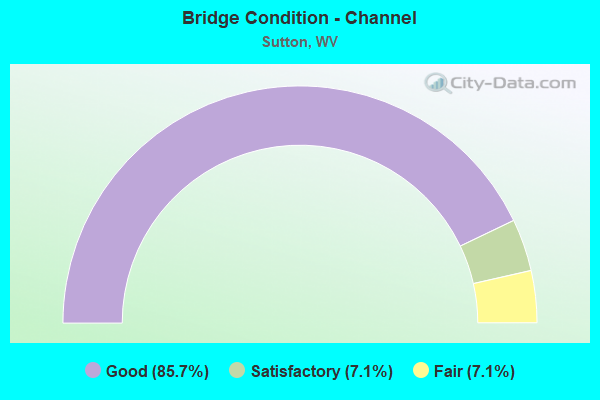
- Bridge Condition - Channel
- 85.7%Good
- 7.1%Satisfactory
- 7.1%Fair
Find on map >> Show street view
Structure Number: 4A019, Location: 0.09 MI S CO 19/25 (Lat: 38.674031, Lng: -80.718469), Route carried "on" structure: County highway 506, Year Built: 1970, Status: Open, Structure Length: 8.03m (26.35ft), Average Daily Traffic: 110 (year 2015), Truck Traffic: 6%, Average Future Daily Traffic: 152 (year 2035), Design Load: HS 20, Features Intersected: CO 5/6, Facility Carried by Structure: COUNTY ROUTE 5/6
Minimum Vertical Clearance: 30+ m (98+ ft), Kilometerpoint: 0.451, Lanes on structure: 2, Lanes under structure: 4, Owner: State Highway Agency, Approaching Roadway Width: 9.8m (32.2ft), Skew: 2 degrees, Material/Design: Steel continuous, Design/Construction: Stringer/Multi-beam, Number Of Spans In Main Unit: 1, Number Of Approach Spans: 2, Length of Maximum Span: 29.3m (96.1ft), Curb-To-Curb Width: 8.1m (26.6ft), Out-to-Out Width: 9.3m (30.5ft)
Condition: Deck: Fair, Superstructure: Satisfactory, Substructure: Fair, Operating Rating: 58.0 metric tons, Method Used To Determine Operating Rating: Load Factor (LF), Inventory Rating: 35.4 metric tons, Method Used To Determine Inventory Rating: Load Factor (LF), Structural Evaluation: Somewhat better than minimum adequacy, Deck Geometry: Somewhat better than minimum adequacy, Underclear: Meets minimum limits, Approach Roadway Alignment: Equal to present desirable criteria, Length Of Structure Improvement: 8.05m (26.41ft), Designated Inspection Frequency: Every 24 months, Other Special Inspection Frequency: Every 24 months, Inspection Date: August 2020, Other Special Inspection Date: June 2020, Bridge Improvement Cost: $300,000, Roadway Improvement Cost: $20,000, Total Project Cost: $400,000 ( Estimate for 2020), Deck Structure Type: Concrete Cast-file-Place, Wearing Surface/Protective System: Wearing Surface: Monolithic Concrete
Find on map >> Show street view
Structure Number: 4A053, Location: 0.74 MI W OF JCT CO 36 (Lat: 38.616989, Lng: -80.663111), Route carried "on" structure: County highway 1700, Year Built: 1991, Status: Open, Structure Length: 1.28m (4.20ft), Average Daily Traffic: 638 (year 2015), Truck Traffic: 6%, Average Future Daily Traffic: 912 (year 2035), Design Load: HS 25 or greater, Features Intersected: LEFT FORK OF WOLF CREEK, Facility Carried by Structure: COUNTY ROUTE 17
Minimum Vertical Clearance: 30+ m (98+ ft), Kilometerpoint: 5.681, Lanes on structure: 2, Owner: State Highway Agency, Approaching Roadway Width: 7.9m (25.9ft), Skew: 4 degrees, Material/Design: Prestressed concrete, Design/Construction: Box Beam or Girders - Multiple, Number Of Spans In Main Unit: 1, Length of Maximum Span: 11.6m (38.1ft), Curb-To-Curb Width: 7.0m (23.0ft), Out-to-Out Width: 7.4m (24.3ft)
Condition: Deck: Satisfactory, Superstructure: Satisfactory, Substructure: Good, Channel: Good, Operating Rating: 74.4 metric tons, Method Used To Determine Operating Rating: Load Factor (LF), Inventory Rating: 58.0 metric tons, Method Used To Determine Inventory Rating: Load Factor (LF), Structural Evaluation: Equal to present minimum criteria, Deck Geometry: Meets minimum limits, Waterway Adequacy: Better than present minimum criteria, Approach Roadway Alignment: Equal to present minimum criteria, Designated Inspection Frequency: Every 48 months, Inspection Date: September 2018, Deck Structure Type: Other, Wearing Surface/Protective System: Wearing Surface: Bituminous, Deck Protection: Epoxy Coated Reinforcing
Find on map >> Show street view
Structure Number: 4A074, Location: 0.01 MI N CO 17/1 (SLS) (Lat: 38.663219, Lng: -80.710050), Route carried "on" structure: County highway 1940, Year Built: 1931, Year Reconstructed: 1991, Status: Open, Structure Length: 11.25m (36.91ft), Average Daily Traffic: 2,400 (year 2018), Truck Traffic: 10%, Average Future Daily Traffic: 2,900 (year 2038), Design Load: HS 20+Mod, Features Intersected: ELK RIVER, Facility Carried by Structure: CO RT 19/40 (SLS)
Minimum Vertical Clearance: 4.52m (14.83ft), Kilometerpoint: 17.751, Lanes on structure: 2, Owner: State Highway Agency, Approaching Roadway Width: 9.8m (32.2ft), Material/Design: Steel, Design/Construction: Truss - Thru, Number Of Spans In Main Unit: 1, Number Of Approach Spans: 2, Length of Maximum Span: 54.9m (180.1ft), Curb or Sidewalk Widths: Left: 0.0m, Right: 1.5m (4.9ft), Curb-To-Curb Width: 9.1m (29.9ft), Out-to-Out Width: 9.1m (29.9ft)
Condition: Deck: Fair, Superstructure: Fair, Substructure: Fair, Channel: Good, Operating Rating: 50.8 metric tons, Method Used To Determine Operating Rating: Load Factor (LF), Inventory Rating: 29.9 metric tons, Method Used To Determine Inventory Rating: Load Factor (LF), Structural Evaluation: Somewhat better than minimum adequacy, Deck Geometry: Meets minimum limits, Waterway Adequacy: Superior to present desirable criteria, Approach Roadway Alignment: Equal to present minimum criteria, Length Of Structure Improvement: 11.28m (37.01ft), Designated Inspection Frequency: Every 24 months, Critical Feature Inspection Frequency: Every 24 months, Underwater Inspection Frequency: Every 60 months, Inspection Date: September 2021, Critical Feature Inspection Date: September 2021, Underwater Inspection Date: July 2019, Bridge Improvement Cost: $3,500,000, Roadway Improvement Cost: $1,000,000, Total Project Cost: $5,000,000 ( Estimate for 2021), Deck Structure Type: Closed Grating, Wearing Surface/Protective System: Wearing Surface: Other, Deck Protection: Galvanized Reinforcing
Find on map >> Show street view
Structure Number: 4A087, Location: 0.12 MI S CO 19/40 (Lat: 38.661381, Lng: -80.715100), Route carried "on" structure: County highway 2800, Year Built: 1975, Status: Posted for load, Structure Length: 1.03m (3.38ft), Average Daily Traffic: 50 (year 2018), Truck Traffic: 6%, Average Future Daily Traffic: 72 (year 2038), Features Intersected: SKIDMORE RUN, Facility Carried by Structure: COUNTY ROUTE28
Minimum Vertical Clearance: 30+ m (98+ ft), Kilometerpoint: 10.445, Lanes on structure: 1, Owner: State Highway Agency, Approaching Roadway Width: 4.3m (14.1ft), Skew: 4 degrees, Material/Design: Steel, Design/Construction: Stringer/Multi-beam, Number Of Spans In Main Unit: 1, Length of Maximum Span: 9.9m (32.5ft), Curb or Sidewalk Widths: Left: 0.2m (0.7ft), Right: 0.2m (0.7ft), Curb-To-Curb Width: 3.7m (12.1ft), Out-to-Out Width: 3.8m (12.5ft)
Condition: Deck: Fair, Superstructure: Satisfactory, Substructure: Satisfactory, Channel: Fair, Operating Rating: 44.4 metric tons, Method Used To Determine Operating Rating: Load Factor (LF), Inventory Rating: 26.3 metric tons, Method Used To Determine Inventory Rating: Load Factor (LF), Structural Evaluation: Equal to present minimum criteria, Deck Geometry: Meets minimum limits, Waterway Adequacy: Meets minimum limits, Approach Roadway Alignment: Equal to present minimum criteria, Bridge Posting: Required (Relationship of Operating Rating to Maximum Legal Load: 0.1 - 9.9% below), Length Of Structure Improvement: 1.68m (5.51ft), Designated Inspection Frequency: Every 24 months, Inspection Date: January 2021, Bridge Improvement Cost: $250,000, Roadway Improvement Cost: $150,000, Total Project Cost: $450,000 ( Estimate for 2021), Deck Structure Type: Wood or Timber, Wearing Surface/Protective System: Wearing Surface: Bituminous
Find on map >> Show street view
Structure Number: 4A088, Location: 0.01 MI S WV 4 (Lat: 38.664281, Lng: -80.730819), Route carried "on" structure: County highway 2805, Year Built: 1966, Status: Open, Structure Length: 7.08m (23.23ft), Average Daily Traffic: 700 (year 2018), Truck Traffic: 6%, Average Future Daily Traffic: 966 (year 2038), Design Load: HS 20, Features Intersected: ELK RIVER, Facility Carried by Structure: COUNTY ROUTE 28/5
Minimum Vertical Clearance: 30+ m (98+ ft), Kilometerpoint: 0.016, Lanes on structure: 2, Owner: State Highway Agency, Approaching Roadway Width: 10.1m (33.1ft), Material/Design: Steel continuous, Design/Construction: Stringer/Multi-beam, Number Of Spans In Main Unit: 1, Number Of Approach Spans: 2, Length of Maximum Span: 27.1m (88.9ft), Curb or Sidewalk Widths: Left: 0.2m (0.7ft), Right: 1.5m (4.9ft), Curb-To-Curb Width: 8.5m (27.9ft), Out-to-Out Width: 10.8m (35.4ft)
Condition: Deck: Satisfactory, Superstructure: Fair, Substructure: Poor, Channel: Good, Operating Rating: 68.0 metric tons, Method Used To Determine Operating Rating: Load Factor (LF), Inventory Rating: 40.8 metric tons, Method Used To Determine Inventory Rating: Load Factor (LF), Structural Evaluation: Meets minimum limits, Deck Geometry: Somewhat better than minimum adequacy, Waterway Adequacy: Equal to present desirable criteria, Approach Roadway Alignment: Equal to present desirable criteria, Designated Inspection Frequency: Every 24 months, Underwater Inspection Frequency: Every 60 months, Other Special Inspection Frequency: Every 12 months, Inspection Date: Febuary 2020, Underwater Inspection Date: June 2021, Other Special Inspection Date: Febuary 2021, Deck Structure Type: Concrete Cast-file-Place, Wearing Surface/Protective System: Wearing Surface: Latex Concrete
Find on map >> Show street view
Structure Number: 4A113, Location: 3.84 MI N US 19 (Lat: 38.655881, Lng: -80.740389), Route carried "on" structure: Interstate 7900, Year Built: 1969, Status: Open, Structure Length: 18.13m (59.48ft), Average Daily Traffic: 9,656 (year 2015), Truck Traffic: 27%, Average Future Daily Traffic: 14,302 (year 2035), Design Load: HS 20+Mod, Features Intersected: Elk Rvr WV 4 Co 28/1, Facility Carried by Structure: I-79 N
Minimum Vertical Clearance: 30+ m (98+ ft), Kilometerpoint: 98.733, Lanes on structure: 2, Lanes under structure: 4, Base Highway Network: Yes, Owner: State Highway Agency, Approaching Roadway Width: 14.0m (45.9ft), Skew: 3 degrees, Material/Design: Steel continuous, Design/Construction: Stringer/Multi-beam, Number Of Spans In Main Unit: 1, Number Of Approach Spans: 3, Length of Maximum Span: 50.1m (164.4ft), Curb-To-Curb Width: 12.2m (40.0ft), Out-to-Out Width: 13.4m (44.0ft)
Condition: Deck: Fair, Superstructure: Satisfactory, Substructure: Fair, Channel: Good, Operating Rating: 65.3 metric tons, Method Used To Determine Operating Rating: Load Factor (LF), Inventory Rating: 39.0 metric tons, Method Used To Determine Inventory Rating: Load Factor (LF), Structural Evaluation: Somewhat better than minimum adequacy, Deck Geometry: Better than present minimum criteria, Underclear: Meets minimum limits, Waterway Adequacy: Superior to present desirable criteria, Approach Roadway Alignment: Equal to present desirable criteria, Designated Inspection Frequency: Every 24 months, Underwater Inspection Frequency: Every 60 months, Inspection Date: April 2020, Underwater Inspection Date: July 2017, Deck Structure Type: Concrete Cast-file-Place, Wearing Surface/Protective System: Wearing Surface: Latex Concrete
Find on map >> Show street view
Structure Number: 4A114, Location: 3.84 MI N OF US 19 (Lat: 38.656381, Lng: -80.740481), Route carried "on" structure: Interstate 7900, Year Built: 1969, Status: Open, Structure Length: 17.44m (57.22ft), Average Daily Traffic: 9,656 (year 2015), Truck Traffic: 27%, Average Future Daily Traffic: 14,302 (year 2035), Design Load: HS 20+Mod, Features Intersected: Elk River, WV 4, Co 28/1, Facility Carried by Structure: I-79
Minimum Vertical Clearance: 30+ m (98+ ft), Kilometerpoint: 98.733, Lanes on structure: 3, Lanes under structure: 4, Base Highway Network: Yes, Owner: State Highway Agency, Approaching Roadway Width: 14.0m (45.9ft), Skew: 3 degrees, Material/Design: Steel continuous, Design/Construction: Stringer/Multi-beam, Number Of Spans In Main Unit: 2, Number Of Approach Spans: 2, Length of Maximum Span: 48.1m (157.8ft), Curb-To-Curb Width: 15.7m (51.5ft), Out-to-Out Width: 17.0m (55.8ft)
Condition: Deck: Fair, Superstructure: Satisfactory, Substructure: Fair, Channel: Good, Operating Rating: 65.3 metric tons, Method Used To Determine Operating Rating: Load Factor (LF), Inventory Rating: 39.0 metric tons, Method Used To Determine Inventory Rating: Load Factor (LF), Structural Evaluation: Somewhat better than minimum adequacy, Deck Geometry: Somewhat better than minimum adequacy, Underclear: Meets minimum limits, Waterway Adequacy: Superior to present desirable criteria, Approach Roadway Alignment: Equal to present desirable criteria, Designated Inspection Frequency: Every 24 months, Underwater Inspection Frequency: Every 60 months, Inspection Date: April 2020, Underwater Inspection Date: July 2017, Deck Structure Type: Concrete Cast-file-Place, Wearing Surface/Protective System: Wearing Surface: Latex Concrete
Find on map >> Show street view
Structure Number: 4A115, Location: 2.21 MI S CO 19/22 (Lat: 38.688289, Lng: -80.695269), Route carried "on" structure: Interstate 7900, Year Built: 1969, Status: Open, Structure Length: 6.86m (22.51ft), Average Daily Traffic: 9,700 (year 2018), Truck Traffic: 23%, Average Future Daily Traffic: 13,871 (year 2038), Design Load: HS 20+Mod, Features Intersected: Brush Run & Co 19/26, Facility Carried by Structure: I-79
Minimum Vertical Clearance: 30+ m (98+ ft), Kilometerpoint: 104.302, Lanes on structure: 2, Lanes under structure: 2, Base Highway Network: Yes, Owner: State Highway Agency, Approaching Roadway Width: 14.0m (45.9ft), Material/Design: Steel continuous, Design/Construction: Stringer/Multi-beam, Number Of Spans In Main Unit: 2, Number Of Approach Spans: 2, Length of Maximum Span: 18.9m (62.0ft), Curb-To-Curb Width: 12.2m (40.0ft), Out-to-Out Width: 13.4m (44.0ft)
Condition: Deck: Satisfactory, Superstructure: Satisfactory, Substructure: Satisfactory, Channel: Good, Operating Rating: 64.4 metric tons, Method Used To Determine Operating Rating: Load Factor (LF), Inventory Rating: 39.0 metric tons, Method Used To Determine Inventory Rating: Load Factor (LF), Structural Evaluation: Equal to present minimum criteria, Deck Geometry: Better than present minimum criteria, Underclear: Superior to present desirable criteria, Waterway Adequacy: Superior to present desirable criteria, Approach Roadway Alignment: Equal to present desirable criteria, Length Of Structure Improvement: 7.01m (23.00ft), Designated Inspection Frequency: Every 24 months, Inspection Date: November 2021, Bridge Improvement Cost: $4,000,000, Roadway Improvement Cost: $500,000, Total Project Cost: $5,500,000 ( Estimate for 2022), Deck Structure Type: Concrete Cast-file-Place, Wearing Surface/Protective System: Wearing Surface: Latex Concrete
Find on map >> Show street view
Structure Number: 4A116, Location: 2.21 MI S CO 19/22 (Lat: 38.688469, Lng: -80.695319), Route carried "on" structure: Interstate 7900, Year Built: 1969, Status: Open, Structure Length: 6.86m (22.51ft), Average Daily Traffic: 9,700 (year 2018), Truck Traffic: 23%, Average Future Daily Traffic: 13,871 (year 2038), Design Load: HS 20+Mod, Features Intersected: Brush Run and Co 19/26, Facility Carried by Structure: I-79
Minimum Vertical Clearance: 30+ m (98+ ft), Kilometerpoint: 104.302, Lanes on structure: 2, Lanes under structure: 2, Base Highway Network: Yes, Owner: State Highway Agency, Approaching Roadway Width: 14.0m (45.9ft), Material/Design: Steel continuous, Design/Construction: Stringer/Multi-beam, Number Of Spans In Main Unit: 2, Number Of Approach Spans: 2, Length of Maximum Span: 18.9m (62.0ft), Curb-To-Curb Width: 12.2m (40.0ft), Out-to-Out Width: 13.4m (44.0ft)
Condition: Deck: Satisfactory, Superstructure: Satisfactory, Substructure: Satisfactory, Channel: Good, Operating Rating: 64.4 metric tons, Method Used To Determine Operating Rating: Load Factor (LF), Inventory Rating: 39.0 metric tons, Method Used To Determine Inventory Rating: Load Factor (LF), Structural Evaluation: Equal to present minimum criteria, Deck Geometry: Better than present minimum criteria, Underclear: Superior to present desirable criteria, Waterway Adequacy: Superior to present desirable criteria, Approach Roadway Alignment: Equal to present desirable criteria, Length Of Structure Improvement: 7.01m (23.00ft), Designated Inspection Frequency: Every 24 months, Inspection Date: November 2021, Bridge Improvement Cost: $4,000,000, Roadway Improvement Cost: $500,000, Total Project Cost: $5,500,000 ( Estimate for 2022), Deck Structure Type: Concrete Cast-file-Place, Wearing Surface/Protective System: Wearing Surface: Latex Concrete
Find on map >> Show street view
Structure Number: 4A164, Location: 0.11 MI S OF CO 19/40 (Lat: 38.668219, Lng: -80.717989), Route carried "on" structure: State highway 400, Year Built: 1998, Status: Open, Structure Length: 2.92m (9.58ft), Average Daily Traffic: 8,318 (year 2015), Truck Traffic: 8%, Average Future Daily Traffic: 11,114 (year 2038), Features Intersected: GRANNY CREEK, Facility Carried by Structure: WV 4
Minimum Vertical Clearance: 30+ m (98+ ft), Kilometerpoint: 37.256, Lanes on structure: 2, Owner: State Highway Agency, Approaching Roadway Width: 9.1m (29.9ft), Material/Design: Prestressed concrete, Design/Construction: Stringer/Multi-beam, Number Of Spans In Main Unit: 1, Length of Maximum Span: 28.0m (91.9ft), Curb or Sidewalk Widths: Left: 0.0m, Right: 1.5m (4.9ft), Curb-To-Curb Width: 9.8m (32.2ft), Out-to-Out Width: 10.8m (35.4ft)
Condition: Deck: Good, Superstructure: Good, Substructure: Satisfactory, Channel: Good, Operating Rating: 88.9 metric tons, Method Used To Determine Operating Rating: Load Factor (LF), Inventory Rating: 76.2 metric tons, Method Used To Determine Inventory Rating: Load Factor (LF), Structural Evaluation: Equal to present minimum criteria, Deck Geometry: Meets minimum limits, Waterway Adequacy: Superior to present desirable criteria, Approach Roadway Alignment: Equal to present desirable criteria, Designated Inspection Frequency: Every 48 months, Inspection Date: September 2020, Deck Structure Type: Concrete Cast-file-Place
Find on map >> Show street view
Structure Number: 4A171, Location: 0.01 MI E CO 7 7 (Lat: 38.681900, Lng: -80.736389), Route carried "on" structure: County highway 1925, Year Built: 1999, Status: Open, Structure Length: 1.07m (3.51ft), Average Daily Traffic: 10 (year 2018), Truck Traffic: 8%, Average Future Daily Traffic: 11 (year 2038), Design Load: HS 25 or greater, Features Intersected: CUTLIPS FORK, Facility Carried by Structure: CO RT 19 25
Minimum Vertical Clearance: 30+ m (98+ ft), Kilometerpoint: 0.016, Lanes on structure: 2, Owner: State Highway Agency, Approaching Roadway Width: 5.2m (17.1ft), Skew: 2 degrees, Material/Design: Steel, Design/Construction: Stringer/Multi-beam, Number Of Spans In Main Unit: 1, Length of Maximum Span: 10.3m (33.8ft), Curb or Sidewalk Widths: Left: 0.2m (0.7ft), Right: 0.2m (0.7ft), Curb-To-Curb Width: 6.1m (20.0ft), Out-to-Out Width: 6.4m (21.0ft)
Condition: Deck: Satisfactory, Superstructure: Good, Substructure: Satisfactory, Channel: Good, Operating Rating: 71.7 metric tons, Method Used To Determine Operating Rating: Load Factor (LF), Inventory Rating: 42.6 metric tons, Method Used To Determine Inventory Rating: Load Factor (LF), Structural Evaluation: Equal to present minimum criteria, Deck Geometry: Somewhat better than minimum adequacy, Waterway Adequacy: Superior to present desirable criteria, Approach Roadway Alignment: Equal to present minimum criteria, Designated Inspection Frequency: Every 48 months, Inspection Date: June 2021, Deck Structure Type: Wood or Timber, Wearing Surface/Protective System: Wearing Surface: Bituminous
Find on map >> Show street view
Structure Number: 4A174, Location: 0.01 MI N OF CO 17/2 (Lat: 38.659331, Lng: -80.697300), Route carried "on" structure: County highway 1701, Year Built: 1999, Status: Open, Structure Length: 1.90m (6.23ft), Average Daily Traffic: 150 (year 2018), Truck Traffic: 8%, Average Future Daily Traffic: 158 (year 2038), Design Load: HS 25 or greater, Features Intersected: BUCKEYE CREEK, Facility Carried by Structure: COUNTY ROUTE 17/1
Minimum Vertical Clearance: 30+ m (98+ ft), Kilometerpoint: 4.329, Lanes on structure: 2, Owner: State Highway Agency, Approaching Roadway Width: 4.9m (16.1ft), Skew: 2 degrees, Material/Design: Prestressed concrete, Design/Construction: Box Beam or Girders - Multiple, Number Of Spans In Main Unit: 1, Length of Maximum Span: 17.7m (58.1ft), Curb-To-Curb Width: 9.2m (30.2ft), Out-to-Out Width: 9.3m (30.5ft)
Condition: Deck: Good, Superstructure: Good, Substructure: Good, Channel: Good, Operating Rating: 64.4 metric tons, Method Used To Determine Operating Rating: Load and Resistance Factor (LRFR), Inventory Rating: 49.9 metric tons, Method Used To Determine Inventory Rating: Load and Resistance Factor (LRFR), Structural Evaluation: Better than present minimum criteria, Deck Geometry: Equal to present minimum criteria, Waterway Adequacy: Better than present minimum criteria, Approach Roadway Alignment: Meets minimum limits, Designated Inspection Frequency: Every 48 months, Inspection Date: November 2021, Deck Structure Type: Other, Wearing Surface/Protective System: Wearing Surface: Bituminous, Deck Protection: Epoxy Coated Reinforcing
Find on map >> Show street view
Structure Number: 4A176, Location: 0.55 MI S WV 4 (Lat: 38.650869, Lng: -80.737700), Route carried "on" structure: Interstate 7900, Year Built: 2000, Status: Open, Structure Length: 19.14m (62.80ft), Average Daily Traffic: 11,150 (year 2018), Truck Traffic: 24%, Average Future Daily Traffic: 15,950 (year 2038), Design Load: HS 25 or greater, Features Intersected: Buffalo Ck and Co 28/2, Facility Carried by Structure: I-79
Minimum Vertical Clearance: 30+ m (98+ ft), Kilometerpoint: 98.009, Lanes on structure: 2, Lanes under structure: 2, Base Highway Network: Yes, Owner: State Highway Agency, Approaching Roadway Width: 14.0m (45.9ft), Skew: 3 degrees, Material/Design: Prestressed concrete continuous, Design/Construction: Stringer/Multi-beam, Number Of Spans In Main Unit: 1, Number Of Approach Spans: 4, Length of Maximum Span: 44.3m (145.3ft), Curb-To-Curb Width: 12.1m (39.7ft), Out-to-Out Width: 13.1m (43.0ft)
Condition: Deck: Good, Superstructure: Satisfactory, Substructure: Satisfactory, Channel: Good, Operating Rating: 65.3 metric tons, Method Used To Determine Operating Rating: Load Factor (LF), Inventory Rating: 36.3 metric tons, Method Used To Determine Inventory Rating: Load Factor (LF), Structural Evaluation: Equal to present minimum criteria, Deck Geometry: Equal to present minimum criteria, Underclear: Superior to present desirable criteria, Waterway Adequacy: Superior to present desirable criteria, Approach Roadway Alignment: Equal to present desirable criteria, Designated Inspection Frequency: Every 24 months, Inspection Date: September 2021, Deck Structure Type: Concrete Cast-file-Place, Wearing Surface/Protective System: Wearing Surface: Latex Concrete, Deck Protection: Epoxy Coated Reinforcing
Find on map >> Show street view
Structure Number: 4A177, Location: 0.55 MI S OF WV 4 (Lat: 38.650850, Lng: -80.738050), Route carried "on" structure: Interstate 7900, Year Built: 2001, Status: Open, Structure Length: 19.89m (65.26ft), Average Daily Traffic: 11,150 (year 2018), Truck Traffic: 24%, Average Future Daily Traffic: 15,950 (year 2038), Design Load: HS 20+Mod, Features Intersected: Buffalo Ck and Co 28/2, Facility Carried by Structure: I-79 S
Minimum Vertical Clearance: 30+ m (98+ ft), Kilometerpoint: 98.009, Lanes on structure: 2, Lanes under structure: 2, Base Highway Network: Yes, Owner: State Highway Agency, Approaching Roadway Width: 14.0m (45.9ft), Skew: 3 degrees, Material/Design: Prestressed concrete continuous, Design/Construction: Stringer/Multi-beam, Number Of Spans In Main Unit: 1, Number Of Approach Spans: 4, Length of Maximum Span: 44.3m (145.3ft), Curb-To-Curb Width: 12.1m (39.7ft), Out-to-Out Width: 13.2m (43.3ft)
Condition: Deck: Good, Superstructure: Satisfactory, Substructure: Satisfactory, Channel: Good, Operating Rating: 59.0 metric tons, Method Used To Determine Operating Rating: Load Factor (LF), Inventory Rating: 24.5 metric tons, Method Used To Determine Inventory Rating: Load Factor (LF), Structural Evaluation: Equal to present minimum criteria, Deck Geometry: Equal to present minimum criteria, Underclear: Superior to present desirable criteria, Waterway Adequacy: Superior to present desirable criteria, Approach Roadway Alignment: Equal to present desirable criteria, Designated Inspection Frequency: Every 24 months, Inspection Date: September 2021, Deck Structure Type: Concrete Cast-file-Place, Wearing Surface/Protective System: Wearing Surface: Latex Concrete
Find on map >> Show street view
Structure Number: CEPLRHWV1112048, Location: SUTTON LAKE CAMPGROUND (Lat: 38.670819, Lng: -80.547586), Route carried "on" structure: ServiceFederal lands road , Year Built: 2020, Status: Open, Structure Length: 0.91m (2.99ft), Average Daily Traffic: 48 (year 2020), Truck Traffic: 1%, Average Future Daily Traffic: 48 (year 2042), Design Load: HL 93, Features Intersected: LOWER KANAWHA RUN, Facility Carried by Structure: CAMPGROUND BRIDGE
Minimum Vertical Clearance: 30+ m (98+ ft), Kilometerpoint: 2.498, Lanes on structure: 2, Owner: Corps of Engineers (Civil), Approaching Roadway Width: 6.0m (19.7ft), Material/Design: Concrete, Design/Construction: Arch - Deck, Number Of Spans In Main Unit: 1, Length of Maximum Span: 9.1m (29.9ft), Curb-To-Curb Width: 6.7m (22.0ft), Out-to-Out Width: 6.7m (22.0ft)
Condition: Superstructure: Good, Substructure: Satisfactory, Channel: Satisfactory, Operating Rating: 18.9 metric tons, Method Used To Determine Operating Rating: Field evaluation and documented engineering judgment, Inventory Rating: 18.0 metric tons, Method Used To Determine Inventory Rating: Field evaluation and documented engineering judgment, Structural Evaluation: Somewhat better than minimum adequacy, Waterway Adequacy: Equal to present minimum criteria, Approach Roadway Alignment: Better than present minimum criteria, Length Of Structure Improvement: 1.80m (5.91ft), Designated Inspection Frequency: Every 24 months, Inspection Date: August 2020, Bridge Improvement Cost: $6,000, Roadway Improvement Cost: $1,000, Total Project Cost: $9,000 ( Estimate for 2020), Wearing Surface/Protective System: Wearing Surface: Gravel
Find on map >> Show street view
Structure Number: 4A019, Location: 0.09 MI S CO 19/25 (Lat: 38.674081, Lng: -80.718469), Route carried "under" structure: Interstate 7900, Year Built: 1970, Structure Length: 0. m, Average Daily Traffic: 19,500 (year 0009), Truck Traffic: 20%, Features Intersected: CO 5/6, Facility Carried by Structure: COUNTY ROUTE 5/6
Minimum Vertical Clearance: 9.37m (30.74ft), Kilometerpoint: 101.727, Lanes on structure: 2, Lanes under structure: 4, Length of Maximum Span: 29.3m (96.1ft)
Find on map >> Show street view
Structure Number: 4A113, Location: 3.84 MI N US 19 (Lat: 38.656481, Lng: -80.740239), Route carried "under" structure: County highway 2801, Year Built: 1969, Structure Length: 0. m, Average Daily Traffic: 100 (year 0009), Features Intersected: Elk Rvr WV 4 Co 28/1, Facility Carried by Structure: I-79 N
Minimum Vertical Clearance: 6.17m (20.24ft), Kilometerpoint: 0.628, Lanes on structure: 2, Lanes under structure: 2, Length of Maximum Span: 50.1m (164.4ft)
Find on map >> Show street view
Structure Number: 4A113, Location: 3.84 MI N US 19 (Lat: 38.656481, Lng: -80.740239), Route carried "under" structure: State highway 400, Year Built: 1969, Structure Length: 0. m, Average Daily Traffic: 5,300 (year 0009), Truck Traffic: 8%, Features Intersected: Elk Rvr WV 4 Co 28/1, Facility Carried by Structure: I-79 N
Minimum Vertical Clearance: 7.80m (25.59ft), Kilometerpoint: 32.702, Lanes on structure: 2, Lanes under structure: 2, Length of Maximum Span: 50.1m (164.4ft)
Find on map >> Show street view
Structure Number: 4A114, Location: 3.84 MI N OF US 19 (Lat: 38.656381, Lng: -80.740481), Route carried "under" structure: County highway 2801, Year Built: 1969, Structure Length: 0. m, Average Daily Traffic: 100 (year 0003), Features Intersected: Elk River, WV 4, Co 28/1, Facility Carried by Structure: I-79
Minimum Vertical Clearance: 6.17m (20.24ft), Kilometerpoint: 0.595, Lanes on structure: 3, Lanes under structure: 2, Length of Maximum Span: 48.1m (157.8ft)
Find on map >> Show street view
Structure Number: 4A114, Location: 3.84 MI N OF US 19 (Lat: 38.656381, Lng: -80.740481), Route carried "under" structure: County highway 400, Year Built: 1969, Structure Length: 0. m, Average Daily Traffic: 5,300 (year 0009), Truck Traffic: 8%, Features Intersected: Elk River, WV 4, Co 28/1, Facility Carried by Structure: I-79
Minimum Vertical Clearance: 7.80m (25.59ft), Kilometerpoint: 32.702, Lanes on structure: 3, Lanes under structure: 2, Length of Maximum Span: 48.1m (157.8ft)
Find on map >> Show street view
Structure Number: 4A115, Location: 2.21 MI S CO 19/22 (Lat: 38.688289, Lng: -80.695269), Route carried "under" structure: County highway 1926, Year Built: 1969, Structure Length: 0. m, Average Daily Traffic: 450 (year 0009), Truck Traffic: 10%, Features Intersected: Brush Run & Co 19/26, Facility Carried by Structure: I-79
Minimum Vertical Clearance: 7.54m (24.74ft), Kilometerpoint: 0.080, Lanes on structure: 2, Lanes under structure: 2, Length of Maximum Span: 18.9m (62.0ft)
Find on map >> Show street view
Structure Number: 4A116, Location: 2.21 MI S CO 19/22 (Lat: 38.688469, Lng: -80.695319), Route carried "under" structure: County highway 1926, Year Built: 1969, Structure Length: 0. m, Average Daily Traffic: 450 (year 0009), Truck Traffic: 10%, Features Intersected: Brush Run and Co 19/26, Facility Carried by Structure: I-79
Minimum Vertical Clearance: 8.10m (26.57ft), Kilometerpoint: 0.080, Lanes on structure: 2, Lanes under structure: 2, Length of Maximum Span: 18.9m (62.0ft)
Find on map >> Show street view
Structure Number: 4A176, Location: 0.55 MI S WV 4 (Lat: 38.650869, Lng: -80.737700), Route carried "under" structure: County highway 2802, Year Built: 2000, Structure Length: 0. m, Average Daily Traffic: 20 (year 0006), Features Intersected: Buffalo Ck and Co 28/2, Facility Carried by Structure: I-79
Minimum Vertical Clearance: 15.88m (52.10ft), Kilometerpoint: 3.557, Lanes on structure: 2, Lanes under structure: 2, Length of Maximum Span: 44.3m (145.3ft)
Find on map >> Show street view
Structure Number: 4A177, Location: 0.55 MI S OF WV 4 (Lat: 38.650850, Lng: -80.738050), Route carried "under" structure: County highway 2802, Year Built: 2001, Structure Length: 0. m, Average Daily Traffic: 20 (year 0006), Features Intersected: Buffalo Ck and Co 28/2, Facility Carried by Structure: I-79 S
Minimum Vertical Clearance: 15.90m (52.17ft), Kilometerpoint: 3.541, Lanes on structure: 2, Lanes under structure: 2, Length of Maximum Span: 44.3m (145.3ft)