Bridge Statistics for Swedesboro, New Jersey (NJ)
Condition, Traffic, Stress, Structural Evaluation, Project Costs
- National Bridge Inventory (NBI) Statistics
- 27Number of bridges
- 249ft / 75.8mTotal length
- $938,000Total costs
- 633,089Total average daily traffic
- 41,144Total average daily truck traffic
- National Bridge Inventory (NBI) Registered Bridges for Swedesboro
- No street view available for this location
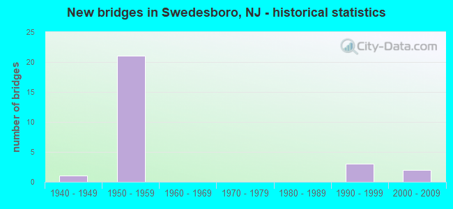
- New bridges - historical statistics
- 11940-1949
- 211950-1959
- 31990-1999
- 22000-2009
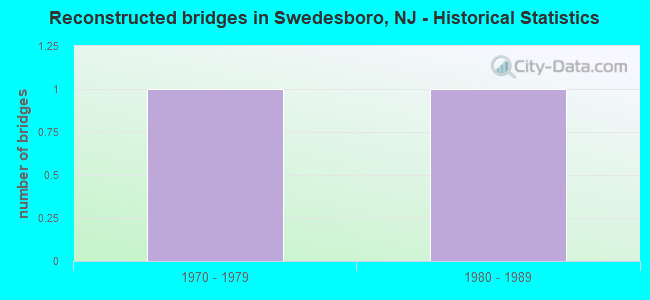
- Reconstructed bridges - Historical Statistics
- 11970-1979
- 11980-1989
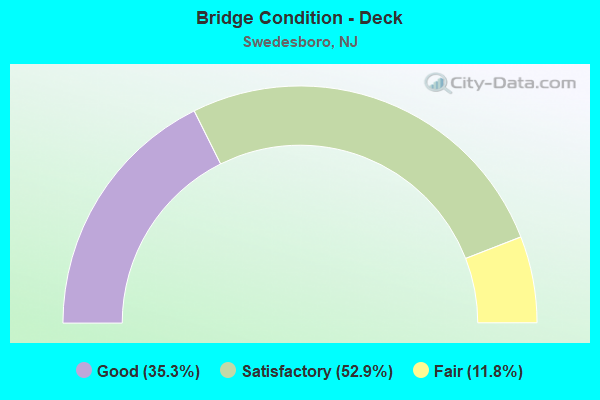
- Bridge Condition - Deck
- 35.3%Good
- 52.9%Satisfactory
- 11.8%Fair
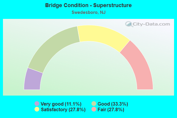
- Bridge Condition - Superstructure
- 11.1%Very good
- 33.3%Good
- 27.8%Satisfactory
- 27.8%Fair
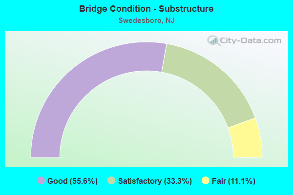
- Bridge Condition - Substructure
- 55.6%Good
- 33.3%Satisfactory
- 11.1%Fair
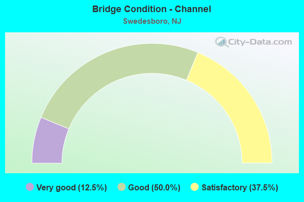
- Bridge Condition - Channel
- 12.5%Very good
- 50.0%Good
- 37.5%Satisfactory
Find on map >> Show street view
Structure Number: 805D03, Location: 0.9 mi South of US 322 (Lat: 39.750789, Lng: -75.305481), Route carried "on" structure: County highway 551, Year Built: 1942, Status: Open, Structure Length: 4.69m (15.39ft), Average Daily Traffic: 9,594 (year 2020), Truck Traffic: 3%, Average Future Daily Traffic: 11,513 (year 2040), Features Intersected: RACCOON CREEK
Minimum Vertical Clearance: 30+ m (98+ ft), Kilometerpoint: 25.927, Lanes on structure: 2, Owner: County Highway Agency, Approaching Roadway Width: 12.2m (40.0ft), Navigation Control: Yes ( Vertical Clearance: 2.4m (7.9ft), Horizontal Clearance: 15.2m (49.9ft)), Material/Design: Steel, Design/Construction: Stringer/Multi-beam, Number Of Spans In Main Unit: 4, Length of Maximum Span: 15.8m (51.8ft), Curb or Sidewalk Widths: Left: 1.6m (5.2ft), Right: 1.6m (5.2ft), Curb-To-Curb Width: 12.2m (40.0ft), Out-to-Out Width: 16.0m (52.5ft)
Condition: Deck: Satisfactory, Superstructure: Good, Substructure: Satisfactory, Channel: Satisfactory, Operating Rating: 64.4 metric tons, Method Used To Determine Operating Rating: Load Factor (LF), Inventory Rating: 39.0 metric tons, Method Used To Determine Inventory Rating: Load Factor (LF), Structural Evaluation: Equal to present minimum criteria, Deck Geometry: Somewhat better than minimum adequacy, Waterway Adequacy: Equal to present desirable criteria, Approach Roadway Alignment: Equal to present desirable criteria, Designated Inspection Frequency: Every 24 months, Underwater Inspection Frequency: Every 48 months, Inspection Date: May 2020, Underwater Inspection Date: May 2020, Deck Structure Type: Concrete Cast-file-Place, Wearing Surface/Protective System: Wearing Surface: Monolithic Concrete
Find on map >> Show street view
Structure Number: 805D04, Location: 0.62 MI SOUTH of US 322 (Lat: 39.755031, Lng: -75.316689), Route carried "on" structure: County highway 671, Year Built: 2004, Status: Open, Structure Length: 6.04m (19.82ft), Average Daily Traffic: 3,502 (year 2020), Truck Traffic: 3%, Average Future Daily Traffic: 4,202 (year 2040), Design Load: HS 25 or greater, Features Intersected: RACCOON CREEK
Minimum Vertical Clearance: 30+ m (98+ ft), Kilometerpoint: 1.191, Lanes on structure: 2, Owner: County Highway Agency, Approaching Roadway Width: 8.8m (28.9ft), Navigation Control: Yes ( Vertical Clearance: 3.4m (11.2ft), Horizontal Clearance: 18.3m (60.0ft)), Material/Design: Prestressed concrete, Design/Construction: Stringer/Multi-beam, Number Of Spans In Main Unit: 2, Length of Maximum Span: 29.0m (95.1ft), Curb or Sidewalk Widths: Left: 1.8m (5.9ft), Right: 0.0m, Curb-To-Curb Width: 9.0m (29.5ft), Out-to-Out Width: 11.6m (38.1ft)
Condition: Deck: Good, Superstructure: Good, Substructure: Good, Channel: Good, Inventory Rating: 58.1 metric tons, Method Used To Determine Inventory Rating: Load Factor (LF), Structural Evaluation: Better than present minimum criteria, Deck Geometry: Meets minimum limits, Waterway Adequacy: Equal to present desirable criteria, Approach Roadway Alignment: Equal to present desirable criteria, Designated Inspection Frequency: Every 24 months, Underwater Inspection Frequency: Every 48 months, Inspection Date: May 2020, Underwater Inspection Date: May 2020, Deck Structure Type: Concrete Cast-file-Place, Wearing Surface/Protective System: Deck Protection: Galvanized Reinforcing
Find on map >> Show street view
Structure Number: 805D05, Location: 0.07 MI EAST OF RT 551 (Lat: 39.749669, Lng: -75.305289), Route carried "on" structure: County highway 538, Year Built: 2009, Status: Open, Structure Length: 0.67m (2.20ft), Average Daily Traffic: 4,455 (year 2020), Truck Traffic: 3%, Average Future Daily Traffic: 5,346 (year 2040), Design Load: HS 25 or greater, Features Intersected: NARRATICON RUN
Minimum Vertical Clearance: 30+ m (98+ ft), Kilometerpoint: 0.129, Lanes on structure: 2, Owner: County Highway Agency, Approaching Roadway Width: 9.1m (29.9ft), Material/Design: Concrete, Design/Construction: Frame, Number Of Spans In Main Unit: 1, Length of Maximum Span: 6.1m (20.0ft), Curb or Sidewalk Widths: Left: 0.0m, Right: 2.4m (7.9ft), Curb-To-Curb Width: 9.1m (29.9ft), Out-to-Out Width: 12.4m (40.7ft)
Condition: Superstructure: Very good, Substructure: Good, Channel: Good, Operating Rating: 59.0 metric tons, Method Used To Determine Operating Rating: Load Factor (LF), Inventory Rating: 35.4 metric tons, Method Used To Determine Inventory Rating: Load Factor (LF), Structural Evaluation: Better than present minimum criteria, Deck Geometry: Meets minimum limits, Waterway Adequacy: Equal to present desirable criteria, Approach Roadway Alignment: Equal to present desirable criteria, Length Of Structure Improvement: 0.61m (2.00ft), Designated Inspection Frequency: Every 24 months, Inspection Date: May 2020, Bridge Improvement Cost: $140,000, Roadway Improvement Cost: $100,000, Total Project Cost: $470,000 ( Estimate for 2020)
Find on map >> Show street view
Structure Number: 805D06, Location: 0.17 mi South of RT 551 (Lat: 39.746711, Lng: -75.307961), Route carried "on" structure: County highway 694, Year Built: 1997, Status: Open, Structure Length: 1.40m (4.59ft), Average Daily Traffic: 4,701 (year 2020), Truck Traffic: 3%, Average Future Daily Traffic: 5,641 (year 2040), Design Load: HS 20+Mod, Features Intersected: NARRATICON RUN
Minimum Vertical Clearance: 30+ m (98+ ft), Kilometerpoint: 0.274, Lanes on structure: 2, Owner: County Highway Agency, Approaching Roadway Width: 9.1m (29.9ft), Material/Design: Prestressed concrete, Design/Construction: Box Beam or Girders - Single/Spread, Number Of Spans In Main Unit: 1, Length of Maximum Span: 12.2m (40.0ft), Curb or Sidewalk Widths: Left: 0.0m, Right: 1.8m (5.9ft), Curb-To-Curb Width: 9.1m (29.9ft), Out-to-Out Width: 11.8m (38.7ft)
Condition: Deck: Good, Superstructure: Very good, Substructure: Good, Channel: Good, Operating Rating: 78.9 metric tons, Method Used To Determine Operating Rating: Load Factor (LF), Inventory Rating: 47.2 metric tons, Method Used To Determine Inventory Rating: Load Factor (LF), Structural Evaluation: Better than present minimum criteria, Deck Geometry: Meets minimum limits, Waterway Adequacy: Equal to present minimum criteria, Approach Roadway Alignment: Equal to present desirable criteria, Designated Inspection Frequency: Every 24 months, Inspection Date: May 2020, Deck Structure Type: Concrete Cast-file-Place, Wearing Surface/Protective System: Wearing Surface: Monolithic Concrete, Deck Protection: Epoxy Coated Reinforcing
Find on map >> Show street view
Structure Number: 805E06, Location: 0.2 MI NORTH of CR 538 (Lat: 39.737481, Lng: -75.282761), Route carried "on" structure: Other road , Year Built: 1993, Status: Open, Structure Length: 0.70m (2.30ft), Average Daily Traffic: 429 (year 2020), Truck Traffic: 3%, Average Future Daily Traffic: 515 (year 2040), Design Load: HS 20, Features Intersected: BASGALORE CREEK, Facility Carried by Structure: RUSSELL MILL RD
Minimum Vertical Clearance: 30+ m (98+ ft), Kilometerpoint: 0.000, Lanes on structure: 2, Owner: County Highway Agency, Approaching Roadway Width: 8.5m (27.9ft), Material/Design: Wood or Timber, Design/Construction: Slab, Number Of Spans In Main Unit: 1, Length of Maximum Span: 6.1m (20.0ft), Curb-To-Curb Width: 10.0m (32.8ft), Out-to-Out Width: 10.6m (34.8ft)
Condition: Deck: Good, Superstructure: Good, Substructure: Good, Channel: Good, Operating Rating: 58.1 metric tons, Method Used To Determine Operating Rating: Allowable Stress (AS), Inventory Rating: 41.7 metric tons, Method Used To Determine Inventory Rating: Allowable Stress (AS), Structural Evaluation: Better than present minimum criteria, Deck Geometry: Equal to present minimum criteria, Waterway Adequacy: Equal to present minimum criteria, Approach Roadway Alignment: Equal to present desirable criteria, Designated Inspection Frequency: Every 24 months, Inspection Date: April 2020, Deck Structure Type: Wood or Timber, Wearing Surface/Protective System: Wearing Surface: Bituminous
Find on map >> Show street view
Structure Number: 805E1, Location: 0.5 mi North of RT 538 (Lat: 39.744131, Lng: -75.280219), Route carried "on" structure: Other road , Year Built: 1996, Status: Open, Structure Length: 1.43m (4.69ft), Average Daily Traffic: 429 (year 2020), Truck Traffic: 3%, Average Future Daily Traffic: 515 (year 2040), Design Load: HS 20+Mod, Features Intersected: RACCOON CREEK, Facility Carried by Structure: RUSSELL MILL ROAD
Minimum Vertical Clearance: 30+ m (98+ ft), Kilometerpoint: 0.000, Lanes on structure: 2, Owner: County Highway Agency, Approaching Roadway Width: 9.1m (29.9ft), Material/Design: Wood or Timber, Design/Construction: Slab, Number Of Spans In Main Unit: 3, Length of Maximum Span: 4.6m (15.1ft), Curb-To-Curb Width: 9.2m (30.2ft), Out-to-Out Width: 9.8m (32.2ft)
Condition: Deck: Good, Superstructure: Good, Substructure: Good, Channel: Satisfactory, Operating Rating: 73.5 metric tons, Method Used To Determine Operating Rating: Allowable Stress (AS), Inventory Rating: 54.4 metric tons, Method Used To Determine Inventory Rating: Allowable Stress (AS), Structural Evaluation: Better than present minimum criteria, Deck Geometry: Equal to present minimum criteria, Waterway Adequacy: Better than present minimum criteria, Approach Roadway Alignment: Equal to present desirable criteria, Designated Inspection Frequency: Every 24 months, Inspection Date: April 2020, Deck Structure Type: Wood or Timber, Wearing Surface/Protective System: Wearing Surface: Bituminous
Find on map >> Show street view
Structure Number: 1700479, Location: 3.2 MILES NORTH OF US 40 (Lat: 39.699181, Lng: -75.333311), Route carried "on" structure: County highway 620, Year Built: 1954, Year Reconstructed: 1984, Status: Open, Structure Length: 2.32m (7.61ft), Average Daily Traffic: 2,480 (year 2021), Truck Traffic: 3%, Average Future Daily Traffic: 3,026 (year 2041), Design Load: HS 20+Mod, Features Intersected: OLDMAN'S CREEK
Minimum Vertical Clearance: 30+ m (98+ ft), Kilometerpoint: 15.144, Lanes on structure: 2, Owner: County Highway Agency, Approaching Roadway Width: 10.5m (34.4ft), Material/Design: Wood or Timber, Design/Construction: Slab, Number Of Spans In Main Unit: 5, Length of Maximum Span: 4.6m (15.1ft), Curb-To-Curb Width: 10.5m (34.4ft), Out-to-Out Width: 11.4m (37.4ft)
Condition: Deck: Good, Superstructure: Good, Substructure: Fair, Channel: Satisfactory, Operating Rating: 65.3 metric tons, Method Used To Determine Operating Rating: Allowable Stress (AS), Inventory Rating: 47.2 metric tons, Method Used To Determine Inventory Rating: Allowable Stress (AS), Structural Evaluation: Somewhat better than minimum adequacy, Deck Geometry: Somewhat better than minimum adequacy, Waterway Adequacy: Equal to present desirable criteria, Approach Roadway Alignment: Equal to present desirable criteria, Designated Inspection Frequency: Every 24 months, Underwater Inspection Frequency: Every 48 months, Inspection Date: August 2021, Underwater Inspection Date: December 2021, Deck Structure Type: Wood or Timber, Wearing Surface/Protective System: Wearing Surface: Bituminous
Find on map >> Show street view
Structure Number: M00868, Location: 4.2 MI SOUTH OF EXIT 2 (Lat: 39.717931, Lng: -75.339850), Route carried "on" structure: County highway 602, Year Built: 1950, Status: Open, Structure Length: 5.30m (17.39ft), Average Daily Traffic: 2,882 (year 2020), Truck Traffic: 3%, Average Future Daily Traffic: 3,516 (year 2040), Design Load: H 20, Features Intersected: NJ TURNPIKE, Facility Carried by Structure: OLDMANS CREEK ROAD
Minimum Vertical Clearance: 30+ m (98+ ft), Kilometerpoint: 6.968, Lanes on structure: 2, Lanes under structure: 4, Owner: State Toll Authority, Approaching Roadway Width: 10.4m (34.1ft), Skew: 1 degrees, Material/Design: Steel continuous, Design/Construction: Stringer/Multi-beam, Number Of Spans In Main Unit: 4, Length of Maximum Span: 16.2m (53.1ft), Curb or Sidewalk Widths: Left: 0.6m (2.0ft), Right: 0.6m (2.0ft), Curb-To-Curb Width: 9.1m (29.9ft), Out-to-Out Width: 11.0m (36.1ft)
Condition: Deck: Fair, Superstructure: Satisfactory, Substructure: Good, Operating Rating: 34.3 metric tons, Method Used To Determine Operating Rating: Load and Resistance Factor Rating (LRFR) rating reported by rating factor(RF) method using HL-93 loadings, Inventory Rating: 26.2 metric tons, Method Used To Determine Inventory Rating: Load and Resistance Factor Rating (LRFR) rating reported by rating factor(RF) method using HL-93 loadings, Structural Evaluation: Equal to present minimum criteria, Deck Geometry: Meets minimum limits, Underclear: High priority of corrective action, Approach Roadway Alignment: Equal to present desirable criteria, Length Of Structure Improvement: 5.30m (17.39ft), Designated Inspection Frequency: Every 24 months, Inspection Date: March 2020, Bridge Improvement Cost: $100,000, Roadway Improvement Cost: $50,000, Total Project Cost: $150,000 ( Estimate for 2016), Deck Structure Type: Concrete Cast-file-Place, Wearing Surface/Protective System: Wearing Surface: Monolithic Concrete
Find on map >> Show street view
Structure Number: M00914, Location: 3.7 MI SOUTH OF EXIT 2 (Lat: 39.721350, Lng: -75.332342), Route carried "on" structure: City street , Year Built: 1950, Status: Open, Structure Length: 4.94m (16.21ft), Average Daily Traffic: 714 (year 2020), Truck Traffic: 3%, Average Future Daily Traffic: 871 (year 2040), Design Load: H 20, Features Intersected: NJ TURNPIKE, Facility Carried by Structure: RAINEY ROAD
Minimum Vertical Clearance: 30+ m (98+ ft), Kilometerpoint: 0.000, Lanes on structure: 2, Lanes under structure: 4, Owner: State Toll Authority, Approaching Roadway Width: 7.3m (24.0ft), Material/Design: Steel continuous, Design/Construction: Stringer/Multi-beam, Number Of Spans In Main Unit: 4, Length of Maximum Span: 15.5m (50.9ft), Curb or Sidewalk Widths: Left: 0.6m (2.0ft), Right: 0.6m (2.0ft), Curb-To-Curb Width: 7.3m (24.0ft), Out-to-Out Width: 9.1m (29.9ft)
Condition: Deck: Satisfactory, Superstructure: Fair, Substructure: Satisfactory, Operating Rating: 35.3 metric tons, Method Used To Determine Operating Rating: Load and Resistance Factor Rating (LRFR) rating reported by rating factor(RF) method using HL-93 loadings, Inventory Rating: 27.2 metric tons, Method Used To Determine Inventory Rating: Load and Resistance Factor Rating (LRFR) rating reported by rating factor(RF) method using HL-93 loadings, Structural Evaluation: Somewhat better than minimum adequacy, Deck Geometry: Meets minimum limits, Underclear: High priority of corrective action, Approach Roadway Alignment: Equal to present desirable criteria, Length Of Structure Improvement: 4.94m (16.21ft), Designated Inspection Frequency: Every 24 months, Inspection Date: March 2020, Bridge Improvement Cost: $212,000, Roadway Improvement Cost: $106,000, Total Project Cost: $318,000 ( Estimate for 2016), Deck Structure Type: Concrete Cast-file-Place, Wearing Surface/Protective System: Wearing Surface: Monolithic Concrete
Find on map >> Show street view
Structure Number: M00971, Location: 3 MI SOUTH OF EXIT 2 (Lat: 39.725108, Lng: -75.323422), Route carried "on" structure: Other road NJTPK, Year Built: 1951, Status: Open, Structure Length: 4.69m (15.39ft), Average Daily Traffic: 51,321 (year 2020), Truck Traffic: 3%, Average Future Daily Traffic: 62,622 (year 2040), Design Load: HS 20, Features Intersected: Kings Highway, Facility Carried by Structure: NJ TURNPIKE
Minimum Vertical Clearance: 30+ m (98+ ft), Kilometerpoint: 15.836, Lanes on structure: 4, Lanes under structure: 2, Base Highway Network: Yes, Toll: On toll road, Owner: State Toll Authority, Approaching Roadway Width: 29.3m (96.1ft), Skew: 35 degrees, Material/Design: Steel continuous, Design/Construction: Stringer/Multi-beam, Number Of Spans In Main Unit: 3, Length of Maximum Span: 20.4m (66.9ft), Curb or Sidewalk Widths: Left: 0.6m (2.0ft), Right: 0.6m (2.0ft), Curb-To-Curb Width: 28.7m (94.2ft), Out-to-Out Width: 30.5m (100.1ft)
Condition: Deck: Satisfactory, Superstructure: Fair, Substructure: Satisfactory, Operating Rating: 31.8 metric tons, Method Used To Determine Operating Rating: Load and Resistance Factor Rating (LRFR) rating reported by rating factor(RF) method using HL-93 loadings, Inventory Rating: 24.3 metric tons, Method Used To Determine Inventory Rating: Load and Resistance Factor Rating (LRFR) rating reported by rating factor(RF) method using HL-93 loadings, Structural Evaluation: Somewhat better than minimum adequacy, Deck Geometry: Superior to present desirable criteria, Underclear: Meets minimum limits, Approach Roadway Alignment: Equal to present desirable criteria, Designated Inspection Frequency: Every 24 months, Inspection Date: March 2020, Deck Structure Type: Concrete Cast-file-Place, Wearing Surface/Protective System: Wearing Surface: Bituminous, Membrane: Epoxy
Find on map >> Show street view
Structure Number: M00993, Location: 2.9 MI SOUTH OF EXIT 2 (Lat: 39.727119, Lng: -75.319908), Route carried "on" structure: Other road NJTPK, Year Built: 1951, Year Reconstructed: 1989, Status: Open, Structure Length: 4.33m (14.21ft), Average Daily Traffic: 51,321 (year 2020), Truck Traffic: 7%, Average Future Daily Traffic: 62,622 (year 2040), Design Load: HS 20, Features Intersected: SO. JERSEY RAILROAD CO., Facility Carried by Structure: NJ TURNPIKE
Minimum Vertical Clearance: 30+ m (98+ ft), Kilometerpoint: 16.222, Lanes on structure: 4, Base Highway Network: Yes, Toll: On toll road, Owner: State Toll Authority, Approaching Roadway Width: 29.6m (97.1ft), Skew: 33 degrees, Material/Design: Steel continuous, Design/Construction: Stringer/Multi-beam, Number Of Spans In Main Unit: 3, Length of Maximum Span: 16.5m (54.1ft), Curb or Sidewalk Widths: Left: 0.6m (2.0ft), Right: 0.0m, Curb-To-Curb Width: 28.7m (94.2ft), Out-to-Out Width: 30.5m (100.1ft)
Condition: Deck: Good, Superstructure: Fair, Substructure: Good, Operating Rating: 35.6 metric tons, Method Used To Determine Operating Rating: Load and Resistance Factor Rating (LRFR) rating reported by rating factor(RF) method using HL-93 loadings, Inventory Rating: 27.5 metric tons, Method Used To Determine Inventory Rating: Load and Resistance Factor Rating (LRFR) rating reported by rating factor(RF) method using HL-93 loadings, Structural Evaluation: Somewhat better than minimum adequacy, Deck Geometry: Superior to present desirable criteria, Underclear: Somewhat better than minimum adequacy, Approach Roadway Alignment: Equal to present desirable criteria, Designated Inspection Frequency: Every 24 months, Inspection Date: March 2020, Deck Structure Type: Concrete Cast-file-Place, Wearing Surface/Protective System: Wearing Surface: Bituminous, Membrane: Preformed Fabric
Find on map >> Show street view
Structure Number: M01004, Location: 1.8 MI SOUTH OF EXIT 2 (Lat: 39.728381, Lng: -75.318019), Route carried "on" structure: Other road NJTPK, Year Built: 1951, Status: Open, Structure Length: 5.85m (19.19ft), Average Daily Traffic: 51,321 (year 2020), Truck Traffic: 7%, Average Future Daily Traffic: 62,622 (year 2040), Design Load: HS 20, Features Intersected: WOODSTOWN-SWEDESBORO RD, Facility Carried by Structure: NJ TURNPIKE
Minimum Vertical Clearance: 30+ m (98+ ft), Kilometerpoint: 16.447, Lanes on structure: 4, Lanes under structure: 2, Base Highway Network: Yes, Toll: On toll road, Owner: State Toll Authority, Approaching Roadway Width: 29.6m (97.1ft), Skew: 33 degrees, Material/Design: Steel continuous, Design/Construction: Stringer/Multi-beam, Number Of Spans In Main Unit: 3, Length of Maximum Span: 21.3m (69.9ft), Curb or Sidewalk Widths: Left: 0.6m (2.0ft), Right: 0.0m, Curb-To-Curb Width: 28.7m (94.2ft), Out-to-Out Width: 30.5m (100.1ft)
Condition: Deck: Satisfactory, Superstructure: Good, Substructure: Good, Operating Rating: 36.0 metric tons, Method Used To Determine Operating Rating: Load and Resistance Factor Rating (LRFR) rating reported by rating factor(RF) method using HL-93 loadings, Inventory Rating: 27.5 metric tons, Method Used To Determine Inventory Rating: Load and Resistance Factor Rating (LRFR) rating reported by rating factor(RF) method using HL-93 loadings, Structural Evaluation: Equal to present minimum criteria, Deck Geometry: Superior to present desirable criteria, Underclear: Meets minimum limits, Approach Roadway Alignment: Equal to present desirable criteria, Designated Inspection Frequency: Every 24 months, Inspection Date: April 2020, Deck Structure Type: Concrete Cast-file-Place, Wearing Surface/Protective System: Wearing Surface: Bituminous, Membrane: Preformed Fabric
Find on map >> Show street view
Structure Number: M01138, Location: 1.44 MI SOUTH OF EXIT 2 (Lat: 39.740425, Lng: -75.298556), Route carried "on" structure: County highway 694, Year Built: 1950, Status: Open, Structure Length: 5.12m (16.80ft), Average Daily Traffic: 4,692 (year 2020), Truck Traffic: 3%, Average Future Daily Traffic: 5,610 (year 2040), Design Load: H 20, Features Intersected: NJ TURNPIKE, Facility Carried by Structure: S'BORO-MONROEVILLE
Minimum Vertical Clearance: 30+ m (98+ ft), Kilometerpoint: 1.400, Lanes on structure: 2, Lanes under structure: 4, Owner: State Toll Authority, Approaching Roadway Width: 10.4m (34.1ft), Material/Design: Steel continuous, Design/Construction: Stringer/Multi-beam, Number Of Spans In Main Unit: 4, Length of Maximum Span: 15.5m (50.9ft), Curb or Sidewalk Widths: Left: 0.6m (2.0ft), Right: 0.6m (2.0ft), Curb-To-Curb Width: 9.1m (29.9ft), Out-to-Out Width: 11.0m (36.1ft)
Condition: Deck: Fair, Superstructure: Satisfactory, Substructure: Good, Operating Rating: 34.3 metric tons, Method Used To Determine Operating Rating: Load and Resistance Factor Rating (LRFR) rating reported by rating factor(RF) method using HL-93 loadings, Inventory Rating: 26.6 metric tons, Method Used To Determine Inventory Rating: Load and Resistance Factor Rating (LRFR) rating reported by rating factor(RF) method using HL-93 loadings, Structural Evaluation: Equal to present minimum criteria, Deck Geometry: Meets minimum limits, Underclear: Meets minimum limits, Approach Roadway Alignment: Equal to present desirable criteria, Designated Inspection Frequency: Every 24 months, Inspection Date: March 2020, Deck Structure Type: Concrete Cast-file-Place, Wearing Surface/Protective System: Wearing Surface: Monolithic Concrete
Find on map >> Show street view
Structure Number: M0115, Location: 1.3 MI SOUTH OF EXIT 2 (Lat: 39.741400, Lng: -75.296700), Route carried "on" structure: County highway 538, Year Built: 1951, Status: Open, Structure Length: 5.36m (17.59ft), Average Daily Traffic: 4,764 (year 2020), Truck Traffic: 3%, Average Future Daily Traffic: 5,723 (year 2040), Design Load: H 20, Features Intersected: NJ TURNPIKE, Facility Carried by Structure: FRANKLINVILLE RD
Minimum Vertical Clearance: 30+ m (98+ ft), Kilometerpoint: 1.352, Lanes on structure: 2, Lanes under structure: 4, Owner: State Toll Authority, Approaching Roadway Width: 10.7m (35.1ft), Skew: 2 degrees, Material/Design: Steel, Design/Construction: Stringer/Multi-beam, Number Of Spans In Main Unit: 4, Length of Maximum Span: 16.5m (54.1ft), Curb or Sidewalk Widths: Left: 0.6m (2.0ft), Right: 0.6m (2.0ft), Curb-To-Curb Width: 9.1m (29.9ft), Out-to-Out Width: 11.0m (36.1ft)
Condition: Deck: Satisfactory, Superstructure: Fair, Substructure: Satisfactory, Operating Rating: 29.5 metric tons, Method Used To Determine Operating Rating: Load and Resistance Factor Rating (LRFR) rating reported by rating factor(RF) method using HL-93 loadings, Inventory Rating: 22.7 metric tons, Method Used To Determine Inventory Rating: Load and Resistance Factor Rating (LRFR) rating reported by rating factor(RF) method using HL-93 loadings, Structural Evaluation: Somewhat better than minimum adequacy, Deck Geometry: Meets minimum limits, Underclear: Meets minimum limits, Approach Roadway Alignment: Better than present minimum criteria, Designated Inspection Frequency: Every 24 months, Inspection Date: Febuary 2020, Deck Structure Type: Concrete Cast-file-Place, Wearing Surface/Protective System: Wearing Surface: Monolithic Concrete
Find on map >> Show street view
Structure Number: M01213, Location: 0.67 MI SOUTH OF EXIT 2 (Lat: 39.746983, Lng: -75.287517), Route carried "on" structure: Other road NJTPK, Year Built: 1950, Status: Open, Structure Length: 3.41m (11.19ft), Average Daily Traffic: 51,321 (year 2020), Truck Traffic: 7%, Average Future Daily Traffic: 62,621 (year 2040), Design Load: HS 20, Features Intersected: RACCOON CREEK, Facility Carried by Structure: NJ TURNPIKE
Minimum Vertical Clearance: 30+ m (98+ ft), Kilometerpoint: 19.875, Lanes on structure: 4, Base Highway Network: Yes, Toll: On toll road, Owner: State Toll Authority, Approaching Roadway Width: 29.3m (96.1ft), Skew: 31 degrees, Material/Design: Steel continuous, Design/Construction: Stringer/Multi-beam, Number Of Spans In Main Unit: 3, Length of Maximum Span: 16.8m (55.1ft), Curb or Sidewalk Widths: Left: 0.6m (2.0ft), Right: 0.6m (2.0ft), Curb-To-Curb Width: 28.7m (94.2ft), Out-to-Out Width: 30.5m (100.1ft)
Condition: Deck: Satisfactory, Superstructure: Fair, Substructure: Satisfactory, Channel: Very good, Operating Rating: 30.5 metric tons, Method Used To Determine Operating Rating: Load and Resistance Factor Rating (LRFR) rating reported by rating factor(RF) method using HL-93 loadings, Inventory Rating: 23.3 metric tons, Method Used To Determine Inventory Rating: Load and Resistance Factor Rating (LRFR) rating reported by rating factor(RF) method using HL-93 loadings, Structural Evaluation: Somewhat better than minimum adequacy, Deck Geometry: Superior to present desirable criteria, Waterway Adequacy: Equal to present desirable criteria, Approach Roadway Alignment: Equal to present desirable criteria, Designated Inspection Frequency: Every 24 months, Inspection Date: March 2020, Deck Structure Type: Concrete Cast-file-Place, Wearing Surface/Protective System: Wearing Surface: Bituminous, Membrane: Preformed Fabric
Find on map >> Show street view
Structure Number: M01258, Location: 0.3 MI SOUTH OF EXIT 2 (Lat: 39.751078, Lng: -75.280950), Route carried "on" structure: City street , Year Built: 1950, Status: Open, Structure Length: 6.58m (21.59ft), Average Daily Traffic: 702 (year 2020), Truck Traffic: 3%, Average Future Daily Traffic: 843 (year 2040), Design Load: H 20, Features Intersected: NJ TURNPIKE, Facility Carried by Structure: BACK CREEK ROAD
Minimum Vertical Clearance: 30+ m (98+ ft), Kilometerpoint: 0.000, Lanes on structure: 2, Lanes under structure: 4, Owner: State Toll Authority, Approaching Roadway Width: 10.7m (35.1ft), Skew: 4 degrees, Material/Design: Steel continuous, Design/Construction: Stringer/Multi-beam, Number Of Spans In Main Unit: 4, Length of Maximum Span: 21.0m (68.9ft), Curb or Sidewalk Widths: Left: 0.6m (2.0ft), Right: 0.6m (2.0ft), Curb-To-Curb Width: 9.1m (29.9ft), Out-to-Out Width: 11.0m (36.1ft)
Condition: Deck: Satisfactory, Superstructure: Satisfactory, Substructure: Good, Operating Rating: 25.6 metric tons, Method Used To Determine Operating Rating: Load and Resistance Factor Rating (LRFR) rating reported by rating factor(RF) method using HL-93 loadings, Inventory Rating: 19.8 metric tons, Method Used To Determine Inventory Rating: Load and Resistance Factor Rating (LRFR) rating reported by rating factor(RF) method using HL-93 loadings, Structural Evaluation: Somewhat better than minimum adequacy, Deck Geometry: Equal to present minimum criteria, Underclear: Meets minimum limits, Approach Roadway Alignment: Equal to present desirable criteria, Designated Inspection Frequency: Every 24 months, Inspection Date: Febuary 2020, Deck Structure Type: Concrete Cast-file-Place, Wearing Surface/Protective System: Wearing Surface: Monolithic Concrete
Find on map >> Show street view
Structure Number: M01286A, Location: AT INTERCHANGE 2 (Lat: 39.753617, Lng: -75.276817), Route carried "on" structure: Ramp Other road NJTPK, Year Built: 1950, Status: Open, Structure Length: 5.43m (17.81ft), Average Daily Traffic: 3,769 (year 2020), Truck Traffic: 7%, Average Future Daily Traffic: 4,599 (year 2040), Design Load: HS 20, Features Intersected: NJ TURNPIKE, Facility Carried by Structure: NJ TPK INT 2 RAMPS
Minimum Vertical Clearance: 30+ m (98+ ft), Kilometerpoint: 20.954, Lanes on structure: 2, Lanes under structure: 5, Toll: On toll road, Owner: State Toll Authority, Approaching Roadway Width: 16.2m (53.1ft), Skew: 20 degrees, Material/Design: Steel continuous, Design/Construction: Stringer/Multi-beam, Number Of Spans In Main Unit: 4, Length of Maximum Span: 18.9m (62.0ft), Curb or Sidewalk Widths: Left: 0.3m (1.0ft), Right: 0.3m (1.0ft), Curb-To-Curb Width: 14.6m (47.9ft), Out-to-Out Width: 15.8m (51.8ft)
Condition: Deck: Satisfactory, Superstructure: Satisfactory, Substructure: Satisfactory, Operating Rating: 34.0 metric tons, Method Used To Determine Operating Rating: Load and Resistance Factor Rating (LRFR) rating reported by rating factor(RF) method using HL-93 loadings, Inventory Rating: 26.2 metric tons, Method Used To Determine Inventory Rating: Load and Resistance Factor Rating (LRFR) rating reported by rating factor(RF) method using HL-93 loadings, Structural Evaluation: Equal to present minimum criteria, Deck Geometry: Superior to present desirable criteria, Underclear: Meets minimum limits, Approach Roadway Alignment: Equal to present desirable criteria, Designated Inspection Frequency: Every 24 months, Inspection Date: April 2020, Deck Structure Type: Concrete Cast-file-Place, Wearing Surface/Protective System: Wearing Surface: Bituminous, Membrane: Preformed Fabric
Find on map >> Show street view
Structure Number: M01318, Location: 0.38 MI NORTH OF EXIT 2 (Lat: 39.756358, Lng: -75.271758), Route carried "on" structure: US 322, Year Built: 1950, Status: Open, Structure Length: 7.50m (24.61ft), Average Daily Traffic: 15,774 (year 2020), Truck Traffic: 5%, Average Future Daily Traffic: 18,929 (year 2040), Design Load: HS 20, Features Intersected: NJ TURNPIKE
Minimum Vertical Clearance: 30+ m (98+ ft), Kilometerpoint: 12.987, Lanes on structure: 2, Lanes under structure: 4, Base Highway Network: Yes, Owner: State Toll Authority, Approaching Roadway Width: 17.1m (56.1ft), Skew: 4 degrees, Material/Design: Steel continuous, Design/Construction: Stringer/Multi-beam, Number Of Spans In Main Unit: 4, Length of Maximum Span: 24.4m (80.1ft), Curb or Sidewalk Widths: Left: 1.8m (5.9ft), Right: 1.8m (5.9ft), Curb-To-Curb Width: 13.5m (44.3ft), Out-to-Out Width: 17.7m (58.1ft)
Condition: Deck: Satisfactory, Superstructure: Satisfactory, Substructure: Fair, Operating Rating: 25.6 metric tons, Method Used To Determine Operating Rating: Load and Resistance Factor Rating (LRFR) rating reported by rating factor(RF) method using HL-93 loadings, Inventory Rating: 19.8 metric tons, Method Used To Determine Inventory Rating: Load and Resistance Factor Rating (LRFR) rating reported by rating factor(RF) method using HL-93 loadings, Structural Evaluation: Somewhat better than minimum adequacy, Deck Geometry: Superior to present desirable criteria, Underclear: Meets minimum limits, Approach Roadway Alignment: Equal to present desirable criteria, Designated Inspection Frequency: Every 24 months, Inspection Date: Febuary 2020, Deck Structure Type: Concrete Cast-file-Place, Wearing Surface/Protective System: Wearing Surface: Monolithic Concrete
Find on map >> Show street view
Structure Number: M00868, Location: 4.2 MI SOUTH OF EXIT 2 (Lat: 39.717931, Lng: -75.339850), Route carried "under" structure: Other road NJTPK, Year Built: 1950, Structure Length: 0. m, Average Daily Traffic: 51,322 (year 2020), Truck Traffic: 9%, Features Intersected: NJ TURNPIKE, Facility Carried by Structure: OLDMANS CREEK ROAD
Minimum Vertical Clearance: 4.78m (15.68ft), Kilometerpoint: 14.259, Lanes on structure: 2, Lanes under structure: 4, Toll: On toll road, Material/Design: Steel continuous, Design/Construction: Stringer/Multi-beam, Length of Maximum Span: 16.2m (53.1ft)
Find on map >> Show street view
Structure Number: M00914, Location: 3.7 MI SOUTH OF EXIT 2 (Lat: 39.721350, Lng: -75.332342), Route carried "under" structure: Interstate 95, Year Built: 1950, Structure Length: 0. m, Average Daily Traffic: 51,322 (year 2020), Truck Traffic: 7%, Features Intersected: NJ TURNPIKE, Facility Carried by Structure: RAINEY ROAD
Minimum Vertical Clearance: 4.57m (14.99ft), Kilometerpoint: 14.999, Lanes on structure: 2, Lanes under structure: 4, Toll: On toll road, Material/Design: Steel continuous, Design/Construction: Stringer/Multi-beam, Length of Maximum Span: 15.5m (50.9ft)
Find on map >> Show street view
Structure Number: M00971, Location: 3 MI SOUTH OF EXIT 2 (Lat: 39.725108, Lng: -75.323422), Route carried "under" structure: County highway 620, Year Built: 1951, Structure Length: 0. m, Average Daily Traffic: 2,043 (year 2020), Truck Traffic: 3%, Features Intersected: Kings Highway, Facility Carried by Structure: NJ TURNPIKE
Minimum Vertical Clearance: 4.34m (14.24ft), Kilometerpoint: 3.026, Lanes on structure: 4, Lanes under structure: 2, Material/Design: Steel continuous, Design/Construction: Stringer/Multi-beam, Length of Maximum Span: 20.4m (66.9ft)
Find on map >> Show street view
Structure Number: M01004, Location: 1.8 MI SOUTH OF EXIT 2 (Lat: 39.728381, Lng: -75.318019), Route carried "under" structure: County highway 605, Year Built: 1951, Structure Length: 0. m, Average Daily Traffic: 3,994 (year 2020), Truck Traffic: 3%, Features Intersected: WOODSTOWN-SWEDESBORO RD, Facility Carried by Structure: NJ TURNPIKE
Minimum Vertical Clearance: 8.25m (27.07ft), Kilometerpoint: 4.136, Lanes on structure: 4, Lanes under structure: 2, Material/Design: Steel continuous, Design/Construction: Stringer/Multi-beam, Length of Maximum Span: 21.3m (69.9ft)
Find on map >> Show street view
Structure Number: M01138, Location: 1.44 MI SOUTH OF EXIT 2 (Lat: 39.740425, Lng: -75.298556), Route carried "under" structure: Other road NJTPK, Year Built: 1950, Structure Length: 0. m, Average Daily Traffic: 51,321 (year 2020), Truck Traffic: 7%, Features Intersected: NJ TURNPIKE, Facility Carried by Structure: S'BORO-MONROEVILLE
Minimum Vertical Clearance: 4.80m (15.75ft), Kilometerpoint: 18.636, Lanes on structure: 2, Lanes under structure: 4, Toll: On toll road, Material/Design: Steel continuous, Design/Construction: Stringer/Multi-beam, Length of Maximum Span: 15.5m (50.9ft)
Find on map >> Show street view
Structure Number: M0115, Location: 1.3 MI SOUTH OF EXIT 2 (Lat: 39.741400, Lng: -75.296700), Route carried "under" structure: Other road NJTPK, Year Built: 1951, Structure Length: 0. m, Average Daily Traffic: 51,321 (year 2020), Truck Traffic: 7%, Features Intersected: NJ TURNPIKE, Facility Carried by Structure: FRANKLINVILLE RD
Minimum Vertical Clearance: 4.88m (16.01ft), Kilometerpoint: 18.797, Lanes on structure: 2, Lanes under structure: 4, Toll: On toll road, Material/Design: Steel, Design/Construction: Stringer/Multi-beam, Length of Maximum Span: 16.5m (54.1ft)
Find on map >> Show street view
Structure Number: M01258, Location: 0.3 MI SOUTH OF EXIT 2 (Lat: 39.751078, Lng: -75.280950), Route carried "under" structure: Other road NJTPK, Year Built: 1950, Structure Length: 0. m, Average Daily Traffic: 51,321 (year 2020), Truck Traffic: 7%, Features Intersected: NJ TURNPIKE, Facility Carried by Structure: BACK CREEK ROAD
Minimum Vertical Clearance: 4.75m (15.58ft), Kilometerpoint: 20.471, Lanes on structure: 2, Lanes under structure: 4, Toll: On toll road, Material/Design: Steel continuous, Design/Construction: Stringer/Multi-beam, Length of Maximum Span: 21.0m (68.9ft)
Find on map >> Show street view
Structure Number: M01286A, Location: AT INTERCHANGE 2 (Lat: 39.753617, Lng: -75.276817), Route carried "under" structure: Other road NJTPK, Year Built: 1950, Structure Length: 0. m, Average Daily Traffic: 51,321 (year 2020), Truck Traffic: 7%, Features Intersected: NJ TURNPIKE, Facility Carried by Structure: NJ TPK INT 2 RAMPS
Minimum Vertical Clearance: 4.67m (15.32ft), Kilometerpoint: 20.954, Lanes on structure: 2, Lanes under structure: 5, Toll: On toll road, Material/Design: Steel continuous, Design/Construction: Stringer/Multi-beam, Length of Maximum Span: 18.9m (62.0ft)
Find on map >> Show street view
Structure Number: M01318, Location: 0.38 MI NORTH OF EXIT 2 (Lat: 39.756358, Lng: -75.271758), Route carried "under" structure: Other road NJTPK, Year Built: 1950, Structure Length: 0. m, Average Daily Traffic: 54,953 (year 2020), Truck Traffic: 7%, Features Intersected: NJ TURNPIKE, Facility Carried by Structure: US 322(SWEDESBORO)
Minimum Vertical Clearance: 4.95m (16.24ft), Kilometerpoint: 21.565, Lanes on structure: 2, Lanes under structure: 4, Toll: On toll road, Material/Design: Steel continuous, Design/Construction: Stringer/Multi-beam, Length of Maximum Span: 24.4m (80.1ft)